Whitetail Fire in South Dakota burns toward Mount Coolidge

(UPDATED at 4:50 p.m. MST March 9, 2017)

The reported size of the Whitetail Fire in Custer State Park in South Dakota increased today t0 249 acres, in contrast to the earlier estimate of 100 to 150 acres. The change is due partially to better mapping, but primarily to large burnout operations to tie in the edge of the fire to firebreaks such as roads or natural barriers.

The cool, damp weather today facilitated quite a bit of progress toward establishing a fireline around the blaze. Containment increased on Thursday and a spokesperson for the fire said some firefighting resources would be released at the end of the shift.

It turns out that contracted Type 1 helicopters were never ordered for the fire, and the National Guard Blackhawk helicopter was not needed today.

****

( Updated at 8:35 a.m. MST March 9, 2017)

The Whitetail Fire in Custer State Park in South Dakota is still estimated at 100 to 150 acres.

The weather on Thursday will help the firefighters, with much lower temperatures and the possibility of precipitation. The high temperature in the area of the fire Thursday will be around 40. The relative humidity will rise throughout the day, reaching 90 percent by sunset as the chance of precipitation increases from 23 percent to 34 percent.

The temperature at a nearby weather station got down to 18 degrees Wednesday night. The most pressing issue for firefighters was probably keeping the plumbing on their fire engines from freezing.

The 3-D map below shows in red the very approximate, rough location of the fire. The exact perimeter is unknown. A spokesperson for the fire we talked with did not know if the fire has reached Highway 87, which is still closed north of Blue Bell Lodge.

map Whitetail Fire
Map showing in red the APPROXIMATE location of the Whitetail Fire as of early morning on March 9, 2017. The burn scars from the 1988 Galena and 1990 Cicero Peak Fires are visible. Click to enlarge.

A firefighter we talked with Wednesday night said the spread of the fire was “hung up” in rocky terrain and discontinuous fuel. The fire is burning in the footprint of the 2004 Cicero Peak Fire, which is the reason for the lack of vegetation to easily carry the fire, especially on flat or downhill runs. If it keeps spreading to the east or northeast and progresses out of the Cicero Peak Fire it would be in older vegetation for a short while before it moves into the scar from the Galena Fire that burned 16,788 acres in 1988.

On Wednesday a Blackhawk helicopter from the National Guard assisted firefighters on the ground by dropping water. Late in the day a fixed wing air attack aircraft arrived that provided eyes in the sky and can help direct the helicopters.

****

(Originally published at 9 p.m. MST, March 8, 2017)

In March and April the Black Hills of South Dakota usually have a two-month prelude to the summer fire season which gets going later — around July. During these two months the snow is usually gone, the temperatures rise, RH drops, the fuels are drying, and it can be windy. Beginning in May greenup occurs and slows things down until the herbaceous vegetation cures in mid-summer.

Whitetail Fire South Dakota
A patch of snow on the Whitetail Fire.

The prelude conditions were present today when a tree fell into a powerline and ignited a fire just west of Custer State Park near the intersection of Lower French Creek Road and Whitetail Road. It was reported at 1:20 p.m. MST; two minutes later the S-NPP VIIRS I Band sensor on a polar orbiting satellite had a single hit, detecting the fire.

During the afternoon a nearby weather station recorded a temperature of 55 degrees, RH in the high 20’s, and sustained southwest to west winds of 10 to 14 mph gusting at 18 to 30. As the strong wind blew the smoke toward the northeast it stayed close to the ground until it rose and mixed with a narrow band of fairly low clouds whose southern edge was right at the fire. From a distance the smoke was difficult to see because of the clouds which seemed to stay in about the same location for hours, in spite of the strong winds.

In the size-up given by the initial attack Incident Commander (IC) about 20 minutes after his arrival he said the estimated size was 15 to 20 acres. In addition to requesting an additional hand crew and a dozer, he asked for single engine air tankers. Told those were not available he requested a large air tanker. After a while the dispatcher came back and said it would take 24 hours to get a large air tanker. He said, well, keep that order in, we can always cancel it. There was discussion about ordering large Type 1 helicopters. Later the IC ordered additional engines, dozers, and hand crews, as well as a Type 3 Incident Management Team.
Whitetail Fire South Dakota
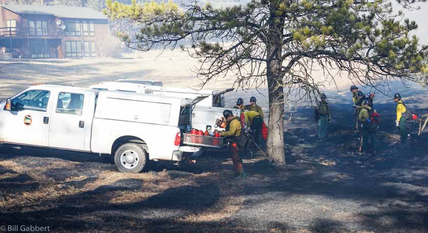
A South Dakota state hand crews gets their gear together after arriving at the Whitetail Fire.

There were about half a dozen structures, including residences, within a quarter mile of the fire’s origin, and the wind was driving it toward Mount Coolidge, at 6,023 feet above sea level it was 1,000 feet higher than the point of origin and 1.3 miles away. On the peak is a fire lookout tower made mostly of stone and there are several electronic sites.

Soon after it started, the fire spread into Custer State Park.

As of 8 p.m. MST on Wednesday the fire had not reached the top of Coolidge.

The size estimate we were able to obtain at 9 p.m was 100 to 150 acres.

Wednesday night Highway 87 in Custer State Park was closed from Blue Bell Lodge to the intersection of Hwy 16A.

Continue reading “Whitetail Fire in South Dakota burns toward Mount Coolidge”

Creating Defensible Space Around Utility Poles

Above: The power pole hazard mitigation crew’s sawyer flush cuts a palo verde stump.

By Tom Story

“As Arizona’s largest utility, there are fire risks we have to manage,” said Wade Ward, Fire Mitigation Specialist for Arizona Public Service (APS). “The primary goal of fire mitigation is to prevent fire from ever happening. The second is to provide safe and reliable electricity to the communities APS serves.  Just as important is the ability to provide for firefighter safety around our system in the event of a fire”, Mr. Ward continued.  “With five thousand miles of transmission and twenty-eight thousand miles of distribution it is hard not to have our system affected by wildland fire.  When this happens, APS’s priority is providing a safe environment for crews to work in”.

defensible space power poles
In Cave Creek, AZ; Wade Ward, Fire Mitigation Specialist for Arizona Public Service, sizes up a palo verde tree slated for removal as part of the APS Defensible Space Around Poles program.

Mr. Ward knows fire (he joined APS after his fire career at the Prescott Fire Department) and he has seen factors like drought, climate change and forest management set the stage for larger and more powerful wildland fires.  “It is becoming more evident that due to extended drought over the past decade forest and vegetation ecosystems have been stressed from the lack of regular moisture compounded by shorter drier winters and longer warmer summers,” Mr. Ward said.

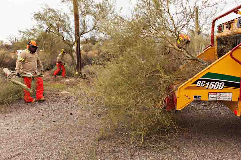
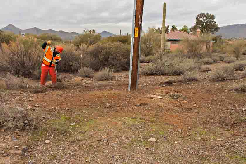
APS sends out inspectors to identify hazardous vegetation in violation of its safety and reliability clearance standards as well as violations of the National Fire Code and the Urban Wildland Interface Code (which state that a utility with equipment attached to the pole must clear all vegetation 10 feet in all directions including 10 feet from the ground). The area around the pole is cleared by work crews to create defensible space.  “There are approximately 70 thousand poles within our system that we will have on a three year return cycle to maintain Defensible Space Around Poles (DSAP)” said Mr. Ward.

defensible space power poles
Other crew members cut up and feed the branches into a chipper.

The clearing is being done using manual methods (including chain saws, string trimmers and other hand tools) and where approved is followed by the application of herbicide in compliance with Environmental Protection Agency’s Integrated Vegetation Management practices. APS has prioritized the treatment of subject poles by utilizing data derived from a risk assessment done across the state. Mr. Ward continued; “It is a part of our core values at APS Forestry to manage vegetation and the environment by balancing benefits to create healthy forests and safe reliable energy”.

Mr. Ward finished his remarks noting, “In 2016 we created 110 acres of defensible space around the state of Arizona. One pole at a time”.

defensible space power poles
Putting the finishing touches on the cleanup around one of the Arizona Public Service power poles in Cave Creek, AZ.

Massachusetts man indicted for planting incendiary devices at powerline

One of the devices started a fire March 31.

This follows up on the first report of the incident on April 1, 2016.

Below is an excerpt from an article in the Lowell [Massachusetts] Sun:

****

“A Chelmsford man accused of planting explosive devices on National Grid power lines in Tyngsboro [Mass.] in March was indicted by a federal grand jury on Tuesday.

Danny Kelly, 61, of Chelmsford, was indicted on a charge of malicious destruction of property by fire. He has been held without bail since his arrest after Tyngsboro firefighters on March 30 responded to Locust Avenue near National Grid power lines for a brush fire that officials suspect was caused by one of five incendiary devices found at the scene.

A note found at the scene explained that the devices were designed to cause disruption to power from Canada to the United States.

Investigators focused on Kelly because in a 2004 case he was convicted of cutting 18 phone and cable lines in an extortion attempt against Nortel Networks, his former employer.

Kelly pleaded guilty to extortion and in 2006, a federal judge sentenced him to five years probation, ordered him to undergo mental-health treatment, possess no destructive devices and pay $378,041 in restitution.

As part of his 2004 case, Kelly was evaluated by Dr. Roger H. Gray, who performed a forensic psychological evaluation. Gray diagnosed Kelly as having symptoms of bipolar and paranoid-personality disorders.

After the incendiary devices were discovered on the National Grid power lines, a raid of Kelly ‘s 26 School St. home by the FBI and other officials yielded chemicals that could be used to make the pipe-bomb-type devices…”

Washington DNR says powerline caused the fatal Twisp River Fire

An investigator’s report on the cause of the fatal Twisp River Fire revealed that a tree branch contacting a power line ignited, dropped to the ground, and started the fire west of Twisp, Washington.

Three firefighters for the U.S. Forest Service were killed inside their vehicle August 19, 2015 when they were attempting to escape from the rapidly spreading fire. A fourth firefighter exited the vehicle and ran to safety. He was severely burned, but survived, hospitalized for three months. The deceased were Tom Zbyszewki, 20, Andrew Zajac, 26, and Richard Wheeler, 31. The injured firefighter was Daniel Lyon, 25, of Puyallup, Washington.

The Seattle Times obtained a copy of the investigation report through a public records request. The entire 38-page document can be seen here.

Thanks and a tip of the hat go out to Kelly.

CAL FIRE’s Butte Fire investigation blames power company for poor line maintenance

CAL FIRE is seeking $90 million in restitution from Pacific Gas and Electric Company.

Map Butte Fire
CAL FIRE’s map of the Butte Fire dated September 12, 2016

An investigation of last September’s 70,868-acre Butte Fire by the California Department of Forestry and Fire Protection determined that poor maintenance of a power line led to a tree contacting the line, causing the blaze. The fire destroyed a total of 921 structures, including; 549 homes, 368 outbuildings, and 4 commercial properties. Only five other fires in California have destroyed more structures.

Two residents were killed in the fire.

In addition to the $90 million that CAL FIRE is seeking from PG&E, 17 law firms are representing 1,800 people who expect to be reimbursed for damages.

And that is not all of the lawsuits. Below is an excerpt from an article in the Sacramento Bee:

…Calaveras County supervisors say they will seek “hundreds of millions in compensation” from PG&E for the fire, estimated to have caused more than $1 billion in damage in that county.

The county expects to file a civil lawsuit in Superior Court, seeking to recover the county’s costs of responding to the fire, cleanup efforts, and losses of public property, county officials said.

“We are shocked and dismayed by the extent of PG&E’s negligence and will actively seek justice for Calaveras County and its citizens,” said Cliff Edson, chair of the Calaveras County Board of Supervisors.

The county will also ask the California Public Utilities Commission to investigate PG&E’s role in the fire, much like the agency did following the fatal 2010 pipeline explosion in San Bruno, said county counsel Megan Stedtfeld. The San Bruno blast killed eight people and destroyed a neighborhood, leading the commission to order the utility to make $1.5 billion in payments to the state and customers and for safety improvements…

Articles on Wildfire Today tagged Butte Fire.

Incendiary devices found on Massachusetts power line

One of the devices is believed to have started a vegetation fire.

Unusual incendiary devices were found hanging from a power line in Massachusetts on March 31. Firefighters reported the objects after they responded to the fire in Tyngsborough.

The photos below are screen grabs from an article at WMUR.com.

Powerline incendiary device Powerline incendiary device

Below is an excerpt from WMUR.com:

…Police said they found cylindrical metal objects on high power lines — that someone deliberately placed there.

“It would take a considerable effort to get up as high as they did in this instance,” said Howe.

Investigators said the devices looked like pipe bombs but were not explosive. They said it appears they were designed to start a fire and had to be manually activated.

“These devices were homemade,” FBI special agent Peter Kowenhoven said. “Those devices are going to now be moved to the FBI lab for analysis to identify the precursor chemicals, as well as the other parts of the device.”

Authorities haven’t said how many devices were found or how they were placed on the power lines.

“I can’t think of any other reason why somebody would want to do that, other than a sinister reason,” said Kowenhoven.

Agents said the fact that the objects were designed to catch fire — not explode — could help them pin down those responsible…

Other electricity transmission facilities in Nogales, Arizona and California’s Silicon Valley were targets of sabotage in 2013 and 2014.