Interstate highway closed after accidents caused by prescribed fire smoke

Investigators will determine if poor visibility was the cause of a fatal accident.

Above: Vehicles at the scene of an accident on Interstate 40 Wednesday, October 19, 2016. Photo by Arizona Department of Public Safety.

(On October 20 we wrote a follow-up article about this incident which looks at the weather forecast and the smoke permit that preceded ignition of the prescribed fire.)

After numerous accidents occurred in thick smoke from a prescribed fire, authorities closed Interstate 40 west of Flagstaff, Arizona on Wednesday. The Kaibab National Forest conducted the burn Tuesday and knew that a wind shift would push the smoke toward the interstate, but they were surprised that the smoke settled near the ground early Wednesday morning rather than being moved out of the area. Electronic signs warned drivers about the potential hazard.

Below is an excerpt from Fox News:

Multiple collisions with minor injuries to motorists and passengers were blamed on smoky haze that settled over the highway for about five hours. Authorities closed I-40 for hours to prevent more accidents.

Police had not immediately determined whether the poor visibility was the cause of a fatal accident after a vehicle was sandwiched between two tractor-trailers before dawn, said Arizona Department of Public safety spokesman Bart Graves.

But the area at this time of year experiences temperature inversions allowing smoke to be trapped close to the ground and hover over the highway, said Cory Mottice, a National Weather Service meteorologist in Flagstaff.

“It almost always gets trapped after dark,” he said. “It’s just a question of where the wind blows it.”

Forest officials thought weather conditions would vent smoke near the freeway more than it did in low-lying areas, Smith said.

“I believed they used good judgment based on the conditions and the information that they had,” said Brady Smith, a U.S. Forest Service spokesperson.

Sequoia NP reintroduces fire where it had been excluded for decades

This week the National Park Service reintroduced fire to an area in Sequoia National Park where it had been unnaturally excluded for decades. The 187-acre Dorst prescribed fire near Dorst Campground is expected to help restore a more natural density of fuels and vegetation.

All photos were provided by the NPS.

Dorst prescribed fire Sequoia National Park
Dorst prescribed fire, October 10, 2016. NPS photo.

Dorst prescribed fire Sequoia National Park

Pile burning on the Beaverhead-Deerlodge NF

Over the last week Derek Wittenberg has been working with his colleagues on the Beaverhead-Deerlodge National Forest in western Montana (map) burning piles that were created while building a fuel break on the Pole Fire. Other piles were part of a project to promote a Whitebark Pine stand that is resistant to Blister Rust.

He posted photos and videos on his Instagram page that are used here with his permission.

Piles like these are often burned while there is snow on the ground in order to minimize the chance of the fires spreading out of control. Some of the keys to success are constructing the piles so that some material remains relatively dry even after rain or snow, and using firefighters that are skilled with a drip torch.

The crew took advantage of the opportunity to conduct training with a Very Pistol.

Veri pistol training and pile burning

A photo posted by Derek Wittenberg (@ridebigmtn) on

#burnpilesinstyle

A video posted by Derek Wittenberg (@ridebigmtn) on


Continue reading “Pile burning on the Beaverhead-Deerlodge NF”

Minam prescribed fire in northeast Oregon escapes control

Above: Minam Fire, Friday September 30, 2016. USFS photo.

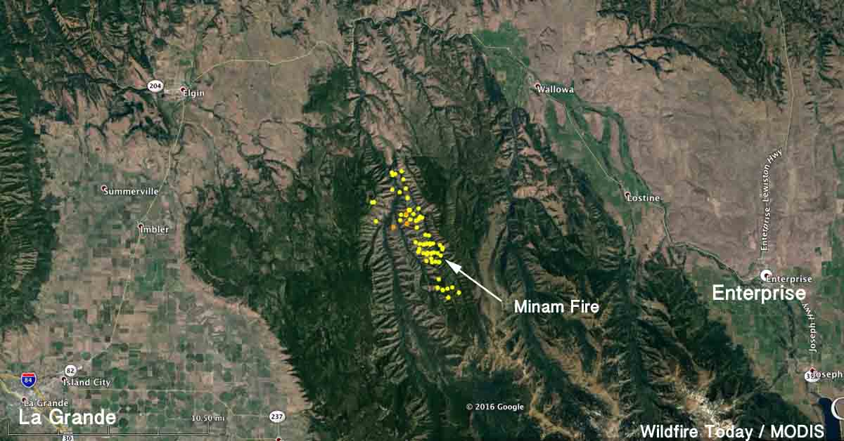
A prescribed fire on the Wallowa-Whitman National Forest escaped the day after it was conducted in northeast Oregon. The 2,000-acre project was ignited with a helicopter on Thursday, September 29 as a continuation of previous prescribed burning activities in the Minam drainage within the Eagle Cap Wilderness Area about 21 miles northeast of La Grande, Oregon.

Late in the afternoon of the next day, Friday, during a helicopter flight to check the status of the project, fire managers found a spot fire east of the burn area across Trout Creek. Due to the time of day, it was determined that firefighters could not safely access the spot fire until the following day.

Map Minam Fire
Map of the Minam Fire, October 3, 2016, showing heat detected by satellites over the previous several days.

Early Saturday, October 1, a powerful thunderstorm moved through the area bringing stronger than expected winds and very little moisture. As planned, firefighters hiked into the spot fire on Saturday and found that the winds had spread the spot fire to the east, upslope onto Cougar Ridge, and ultimately outside the planned prescribed fire area.

The Minam Fire was declared an escape Saturday afternoon, October 1st, when fire managers determined that they would not be able to contain the portion of the fire that had spread outside of the planned perimeter within the next 24 hours, which is a criteria for declaring an escaped prescribed fire.

Cooler weather kept the spread of the fire minimal into Sunday as additional crews and aircraft arrived on scene to support the suppression efforts.

As of Sunday, October 2, the escaped fire had burned 750 acres.

Researchers study how to reduce soot produced by agricultural fires

agricultural burning smoke
Smoke plume from the burning of wheat residue on the Nez Perce Reservation. The field was burned using a head fire. The dark color of the smoke plume indicates high soot content. Photo by Emily Lincoln.

The production cycle of cereal crops and grasses in many areas of the United States includes burning fields of post-harvest residue such as wheat stubble. Like smoke from forest fires, smoke produced by agricultural burning can have harmful effects on public health.

The U.S. Forest Service and the Washington State Department of Ecology conducted a study to determine the effects different ignition tactics had on the smoke produced by agricultural burning of wheat residue.

agricultural burning smoke
Smoke plume from the burning of wheat residue north of Walla Walla, Washington. The field was burned using a backing fire. The light color of the smoke plume indicates low soot content. Photo by Emily Lincoln.

They found that smoke plumes produced from burning wheat residue using head fires contained more soot than plumes produced using backing fires.

Soot particles are black aerosols composed primarily of elemental carbon. The World Health Organization reports that soot particles may have significantly greater negative health impacts than other particle types found in smoke and air pollution since these particles can act as a carrier for toxic combustion-derived chemicals.

Senator wants to require more steps before beginning a prescribed fire

Senator John Thune has been critical of federal firefighters previously.

A U.S. Senator has proposed an amendment to introduced legislation that would require additional procedures before federal agencies could conduct a prescribed fire. Senator John Thune from South Dakota wants to require consultation with local and state fire officials before the project begins. One of his reasons is that he contends local and state officials know more than the federal professional prescribed fire managers.

“Local officials are going to know a little bit more about what the conditions are in the area”, Senator Thune said in a newsletter distributed by his office on September 15.

This requirement has been offered as an amendment to a Republican backed bill introduced by Senator Pat Roberts of Kansas June 22, 2016, titled S.3085 – Emergency Wildfire and Forest Management Act of 2016. Senator Thune contends that the amendment was adopted by unanimous consent during a Senate Agriculture Committee markup, but no official action after the introduction is showing up at bill-tracking websites. After three months the bill has no cosponsors, and GovTrack.us predicts a 2 percent chance of it being enacted.

The primary purpose of the bill is to eliminate some environment restrictions for planned “forest management activities”. The list of these activities is long and vague enough to cover a very wide range of land treatments, including timber harvesting.

Senator Thune advocated his consultation procedure before when he introduced a stand-alone bill in 2015. It had one cosponsor and never advanced beyond being introduced. Apparently the powerful Senator did not work hard to promote his idea, or perhaps he only wanted some publicity. 

Senator Thune has generated publicity before in matters regarding prescribed fire. In 2015 he distributed to the media a strongly-worded very critical letter he sent to the Secretary of the Interior after the Cold Brook prescribed fire in Wind Cave National Park in South Dakota escaped, burning an additional 5,420 acres of prairie. It never spread beyond the park boundaries.

Four days after the escape and months before the official report came out, the Senator was apparently very satisfied that he knew exactly the cause, writing to the Secretary, “The Cold Brook Fire could easily have been prevented”, and “the intense smoke will likely damage the lungs of young calves in the vicinity resulting in high risk of pneumonia and death loss.”

Ready. Fire. Aim.

Cold Brook Fire
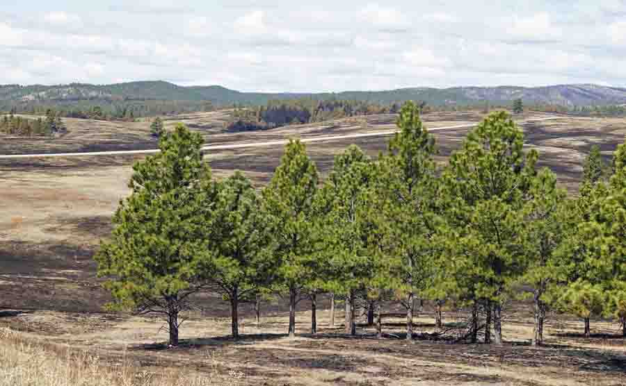
Highway 385, which can be seen in the distance, was supposed to be the boundary of the Cold Brook prescribed fire. Only the land on the far side of the highway was intended to burn. Photo taken a few days after the fire by Bill Gabbert.
Wind Cave prescribed fire
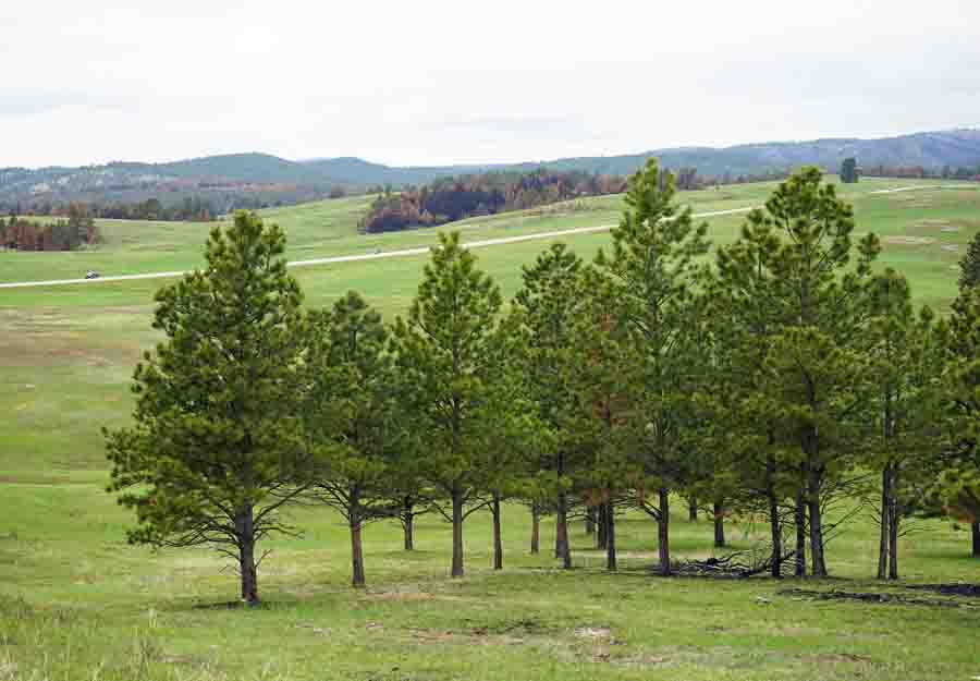
Photo taken of the area where the Cold Brook prescribed fire crossed US Highway 385, taken 39 days after the fire. Photo by Bill Gabbert.

The escaped fire was in grass and ground fuels beneath scattered trees that had been treated with prescribed fire before, and there was no significant crowning. It was basically over after one afternoon, but that didn’t stop Senator Thune from prognosticating about the lung condition of calves outside the park.