Report released on fatal BLM engine rollover

BLM Unimog fire engine 2410

BLM Unimog Engine 2410 when it was new in 2006. BLM photo.

The Bureau of Land Management has released an Accident Investigation Factual Report for the July 10, 2016 engine rollover north of Winnemucca, Nevada in which two firefighters were killed and a third was seriously injured.

Jacob O’Malley and Will Hawkins lost their lives in the single-vehicle accident on Nevada State Route 140 when a rear tire suddenly and catastrophically failed. The truck only had four tires, there were no duals on the rear. When the right-rear rim dragged along the pavement the left-front was in the air, eliminating any possibility of control by the driver. The 33,000 pound GVWR engine fishtailed and then rolled several times.

The cab was higher than the water tanks and pump package, so it took the majority of the impact as the top of the vehicle struck the roadway during the rollover. All three occupants were wearing seat belts but with the top of the cab and the A pillar being damaged or sheared off, the restraint system failed to operate as designed. Mr. Hawkins was ejected from the cab and then was hit by the rolling wreckage.

Below is an excerpt from the report:

Finding 3.1 (Material): During the rollover, the upper cab structure (made of reinforced carbon fiber) sheared away from the truck frame, exposing the vehicle’s occupants to a hazardous environment. The disintegration of the cab compromised the driver’s and right side passenger’s seatbelt systems.

Discussion 3.1: The lack of cab crashworthiness did not cause the rollover; however, it contributed to the fatal conditions which occurred during the crash. The reinforced carbon fiber cab on the Unimog was manufactured in France and was built to United Nations Code ECE r29 (commercial vehicle occupant protection), which exceeds U.S. cab crashworthiness standards. The U.S. National Highway Traffic Safety Administration (NHTSA) submitted a report to Congress in 2015 on the need for improved heavy truck crashworthiness standards; however, no action has been taken on this report as of February 2017.

There are 41 articles on Wildfire Today about the rollovers of wildland fire apparatus.

We still stand behind what we wrote in a 2015 article about the many firefighter fatalities from rollovers:

The wildland fire agencies should fund research conducted by engineers to determine how to prevent the passenger compartments in their fire engines from collapsing in accidents.

Thanks and a tip of the hat go out to Eric.
Typos or errors, report them HERE.

Two reports released on the same day about the escaped prescribed fire near Carson City, NV

Map Little Valley Fire

Above: Map of the Little Valley Fire at 9:23 p.m. PDT October 14, 2016.

On February 15 two reports were released about the prescribed fire that escaped, burned 2,291 acres, and destroyed 23 homes northwest of Carson City, Nevada on October 14, 2016. The first report about what became the Little Valley Fire included the results of a months-long independent investigation by the Reno Gazette-Journal (RGJ). The other, released a few hours later, was the product of the official investigation requested by the Nevada Division of Forestry (NDF), the agency responsible for conducting the prescribed fire.

Hours before the fire escaped, all eleven firefighters that had been mopping up the prescribed fire left the project and returned to their stations between 1:30 p.m. and 4:45 p.m. on October 13, 2016. During that day there were a number of smokes that received the attention of the firefighters. During the last two hours before the seven-person helitack crew departed they noticed the wind increasing — trees were blowing down and branches were falling.

The RGJ reported on the reason the firefighters were ordered to leave the burn site.

Gene Phillips, NDF forest health specialist and burn boss for the Little Valley Burn, made the decision to pull crews from the burn site after discussing the high wind forecasts for the evening with a burn boss trainee, according to the review.

The decision not to staff the site on the evening of Oct. 13 was made, according to NDF, “based on the limited amount of heat near the control lines, success of the current mop-up effort, and the risk to firefighters working in timber during high winds.”

escaped fire map
From the NIMO report.

At 5:38 p.m. the Little Valley weather station recorded sustained winds out of the west at 15 mph with a maximum gust of 39 mph. By 12:38 a.m. on October 14, about the time the fire escaped, the wind was at 19 mph with gusts up to 87 mph. The relative humidity was 32 percent.

A Red Flag Warning for gusty winds and low humidity was in effect from the morning of October 11 through 5 p.m. on October 14. Strong winds persisted until mid-day on October 17.

The NDF’s report was written by the U.S. Forest Service’s Phoenix National Incident Management Organization (NIMO), a team that usually manages fires and other incidents that are often of longer duration than a typical wildfire. The team was supplemented with a Fire Behavior Analyst, a GIS/Fire Behavior Analyst, a Public Information Officer, a Fire Investigator, and others for a total of 10 personnel that were listed in the report.

The NIMO team concluded that the fire escaped when embers from a burning stump hole were blown 34 feet and crossed the fireline at a corner, or “dog leg” in the fire perimeter.

According to the RGJ there was confusion in initially responding to the fire after it escaped at around 12:38 a.m. on October 14:

Response to the fire was delayed, affecting how fast it could be contained: A call at 1:23 a.m. about smoke at the burn site was later dismissed as “unfounded,” causing a TMFPD [Truckee Meadows Fire Protection District] fire engine to return to the station three minutes after it left. After a second call about smoke at the burn site, it took TMFPD more than an hour to get to the site after crews were dispatched, according to 911 transcripts.

Dozer rollover on the Trailhead Fire

Dozer rollover fire

Above: Dozer rollover at the Trailhead Fire on the Eldorado National Forest in California July 2, 2016. Photo from the report.

A report has been released by the Wildland Fire Lessons Learned Center about a dozer rollover that occurred July 2, 2016 at the Trailhead Fire on the Eldorado National Forest in California. You can read the entire report, but here’s a brief summary.

After getting unstuck from being high centered on a large stump, a dozer operator found himself off the ridge where he was building an indirect fireline, and was on a steep slope. Again he got stuck and was not able to backup, this time due to the slope which in places exceeded an 80 percent incline. At various times he was advised by two Resource Advisors, the Structure Group Supervisor, and the owner of the dozer to stay put. In the meantime another dozer with a winch was en route to assist.

Ignoring the advice, the operator continued down the slope and got into a heated argument with the owner, who then left the area. Determined to get the dozer back up to the ridge top, the operator began building a road and creating pads where he could work to push over trees that were in his way, including a 30-DBH cedar which missed by 50 feet the two Resources Advisors who had to run to get out of the way.

The incident-within-an-incident finally came to an end, at least temporarily, when the dozer rolled over onto its side. The operator escaped with only a scratch, after which the dozer continued to roll over onto its top in the creek bottom.

The report did not include information about how the dozer was eventually extracted, or what repercussions, if any, befell the operator and the contractor.

Report released for burn injuries on Tokewanna Fire

On July 29 a member of the Great Basin Smokejumpers was injured while scouting fireline on the Tokewanna Fire near Mountain View in southwest Wyoming. The firefighter sustained burn injuries to the hands, calves, knees, elbows, cheeks, nose and ears. He was transported by air ambulance to the Salt Lake Burn Center where he was admitted.

The fire started at about 1500 on July 28. The overhead structure worked through the night and began transitioning to replacement personnel after smokejumpers arrived at approximately 1252 on July 29. The person that was later burned became the new Division Supervisor (DIVS) on Division W at 1300. Official transition to the new Incident Commander occurred at 1505.

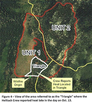
map burn injury report
Illustration from the report.

Below is an excerpt from the Factual Report that was completed September 15, 2016:

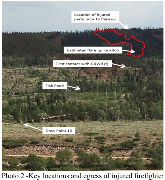
“Between 15:30 and 15:45 the DIVS was scouting fireline and reached the highest point of where the fire had progressed on the ridge. At this location a flare up occurred downhill from the DIVS on the other side of a large stringer of lodgepole pine which had been heavily treated with retardant (Reference Materials photos 2-5). The DIVS stated, “I heard something I didn’t like and determined I needed to leave.” He retreated to his predetermined safety zone, which was the black and opted to continue downhill rapidly. While retreating he experienced an extreme pulse of radiant heat coming from the right accompanied by smoke and blowing ash. Because of the pulse of radiant heat, he used his helmet to shield the right side of his face. In recounting this he expressed “I wish I had my gloves on, but prior to the event I was away from the fire edge using a GPS and taking notes in my notepad.” The radiant heat caused burns to the DIVS’s hands, calves, knees, elbows, cheeks, nose and ears.”

Also from the report:

“Summary

Three key findings were brought out during this investigation:

  • Timely recognition and reporting of burn injuries is critical
  • The absence of PPE can contribute to the severity of injuries
  • Firefighters were unable to contact the air ambulance utilizing pre-established radio frequencies

Lessons Learned from the Interviewees:

When asked if there were any lessons learned or best practices the interviewees would take away from the incident the following was captured:

  • Recognize your own limitations and don’t expect to have all of the answers or information on a rapidly emerging fire.
  • Time of day and incident complexity were not optimal for transferring command, but in this case it was a better option than continuing to utilize fatigued resources.
  • Sometimes you just need to safely engage to ensure you are not transferring risk to someone else later.
  • Make the time to tie-in with your overhead to assure face-to-face interactions occur during transition.
  • Participation with district resources in pre-season scenario based training alleviated tension while coordinating a real life medical incident at the dispatch center.
  • Frequency sharing with local EMS will help facilitate efficient medevac procedures.
  • Continue to encourage EMS certifications among line firefighters and/or identify ways to improve access to Advanced Life Support on emerging incidents.”

Report released on entrapment of six firefighters on the Cedar Fire in Arizona

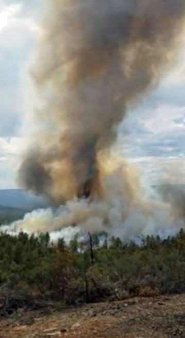
cedar fire entrapment

Above: Fire whirl on the Cedar Fire, June 28, 2016, around the time of the entrapment. Screen grab from the video.

A report has been released on the entrapment of six firefighters that occurred on the Cedar Fire south of Show Low, Arizona June 28, 2016.

The firefighters were part of the Navajo Interagency Hotshot Crew (NIHC) that remained along with two Type 6 engines and possibly one other crew after the Type 1 Incident Management Team was released the previous day. The assignment of half the crew, nine firefighters, was to “monitor” a part of the southwest side of the fire that had six miles of uncontained fire edge. The other half was working on the southeast side.

Three of the nine personnel on the southwest side served as lookouts while the remaining six were monitoring and checking the fire edge. When a very large fire whirl developed near the six, they realized their escape route was cut off, and took refuge in a previously burned area. The ground fuels had burned, but the canopy was still intact. As the fire approached they deployed their fire shelters, remaining in them for about 30 minutes.

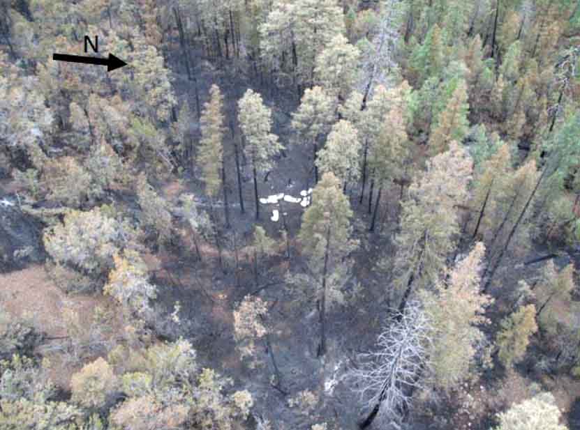
cedar fire entrapment site
The entrapment site at the Cedar Fire.

After the fire whirl subsided, the squad members were able to hike out to staged vehicles. They were transported in three ambulances, medically evaluated, and transported to Summit Hospital in Show Low, Arizona where they were evaluated. Two firefighters were treated for smoke inhalation and all were released by 10 p.m. that evening.

The report says the personnel deployed and entered the shelters just as they had practiced several times in training, and the devices worked as designed. There were no difficulties, as reported at other entrapments, with the PVC bags becoming soft and difficult to open.

Thankfully there were no serious injuries and the training the firefighters had received paid off.

But there are a number of interesting facts about what occurred before the entrapment

Resources on the fire

On June 27, the day before the entrapment, the Type 1 Incident Management Team issued their final update on the 45,977-acre fire just before they were released later that day. Below is a portion of the document.

cedar fire update

The report claims the Type 1 Team recommended that the number of personnel assigned be reduced on Tuesday June 28 to about 400. But on Monday, June 27 all firefighters except for two Type 6 engines were released. With a 70 percent chance of rain in the weather forecast, on Tuesday the local agency decided to replace the Type 1 Team with a Type 4 Incident Commander, two Type 6 engines, and one or two hand crews. The crew(s) had to be re-mobilized on Tuesday after being released. Some aircraft were also assigned on Tuesday.

Video of the large fire whirl

Weather on Tuesday, the day of entrapment

About 20 minutes before the 2:45 p.m. entrapment the weather at the fire was 95 degrees, 21 percent relative humidity, with a 7 to 10 mph wind out of the south. Although “numerous” people observed dust devils and fire whirls before the large fire whirl formed, there was no discussion about modifying fire suppression tactics. Dust devils can be an indicator of the potential for extreme fire behavior.

cedar fire entrapment
Fire whirl on the Cedar Fire, June 28, 2016. Screen grab from the video.

Report released on burnover of CAL FIRE engine

The California Department of Forestry and Fire Protection has released what they call a “Green Sheet”, a summary of the burnover of an engine that occurred as it was making a mobile attack on the Pacheco Fire, which eventually burned 341 acres in Calaveras County south of Valley Springs.

****

“SUMMARY

On July 12, 2016, a CAL FIRE Type 3 Model 34 engine (E1) attempted to start a mobile attack toward the head of a vegetation fire. Firefighters deployed two lines, but before they could anchor and start the mobile attack, the main fire and several spot fires converged on the fire engine. One firefighter took refuge in the engine, and one firefighter ran into the green. The engine sustained damage from the fire. Neither firefighter was injured.

CONDITIONS

  • Weather: 89°, 21% relative humidity, winds 9 mph from the west and shifting, taken from the Campo Seco RAWS at 1400 hours.
  • Fuel Type: Approximately two feet tall grass.
  • Topography: Southeast aspect, rolling topography with multiple draws
  • Fire Behavior: Sheeting, fire whirls, spotting

SEQUENCE OF EVENTS

On July 12, 2016, at approximately 1314 hours, CAL FIRE and local government resources were dispatched to a vegetation fire in the vicinity of Langford Pacheco Road and Milton Road in Calaveras County. The initial report on conditions given by the Air Attack at 1329 hours was 15 acres of grass woodland and spotting out in front of the main fire. At 1356 hours, the fire was reported to be 100 acres in size and spotting under the column.

A CAL FIRE engine (E1) arrived at scene at 1345 hours and was assigned Division R, the right flank of the fire. The crew met with a Battalion Chief (BC1) and came up with a plan to create an anchor point and start a mobile attack toward the head of the fire. A second CAL FIRE Engine (E2) and Dozer (D1) were just behind E1.

As E1 crossed through a gate to make access to the fire. E1 stopped in the green and deployed a one inch THY-600 Angus line manufactured by Rawhide Fire, with a 3/8 inch tip for the mobile attack and a reel line to pick up any spot fires. The Captain (FC1) on E1 saw the engine was between the main fire and multiple spot fires. Winds were shifting and the fire behavior was erratic so FC1 from E1 gave the order to pick up the lines so they could move to a better location. As the two firefighters (FF1 and FF2) began to roll up the hose, the main fire and spot fires converged and burned up to the engine. FF1 jumped into the engine while FF2 ran away from the engine into the green, losing his helmet. FC1 lost sight of FF2, and seeing only flames, announced on the tactical frequency that a fire fighter had been burned over. Engine E2 radioed to E1 that they were heading toward them. A large fire whirl was between E2 and E1.

Uninjured, FF2 looked back toward E1 from the green and saw the under carriage of the engine was on fire. FF2 contacted E1 on the radio and told them the engine was on fire. FF1 exited the cab and used the reel line to extinguish the fire under the engine.

Flame impingement caused the airlines above the frame rails to burst. When the air pressure dropped below 60 psi, FC1 was unable to release the spring brake. FF2 ran back to E1. A helicopter dropped water around E1 while D1 constructed line around a portion of E1 to protect the crew. FC1 notified the Incident Commander that all personnel were accounted for and in a good location.

There were no injuries. E1 sustained heat damage to the tires, fenders, lens covers, air brake lines and pump panel.

CAL FIRE engine damage

SAFETY ISSUES FOR REVIEW AND LESSONS LEARNED

STANDARD FIRE ORDERS

  • Base all actions on current and expected fire behavior.

WATCH OUT SITUATIONS

  • Wind increases and/or changes direction.
  • Getting frequent spot fires across line.

LESSONS LEARNED

  • Consider topographical features and fuels, no matter how minor, in relation to you and/or your vehicle’s location to anticipate fire behavior.
  • Base actions on current fire situation and activity potential.
  • Properly wear your PPE”

Review of the 2015 wildfire season in the Northwest

Cougar Creek Fire 2015

Photo above: Firefighters observe the Cougar Creek Fire southeast of Mt. Adams in southern Washington in 2015. From InciWeb.

The U.S. Forest Service has produced an exhaustive summary and review of the 2015 wildfire season in what they call their Pacific Northwest Region — what the interagency community calls the Northwest Geographic Area — Oregon and Washington.

The report is huge, 281 pages. In addition to general information about the fire activity, it includes sections about weather, air quality, technology, and summaries of 28 fires with 14 of those being covered in greater detail than the others.

The main 281-page report can be be found here (it’s a LARGE file). There is another version they call an “Interactive Story Journal” which provides summary information from the main report as well as interactive web maps, videos, and numerous photos as well as “time-enabled fire progression maps” for selected fires.

Below are some excerpts from the report:

****

Most Severe Fire Season in Modern History

The 2015 fire season in the Pacific Northwest was the most severe in modern history from a variety of standpoints. Oregon and Washington experienced more than 3,800 wildfires (almost 2,300 in Oregon and more than 1,500 in Washington) that burned more than 1,600,000 acres (more than 630,000 acres in Oregon and more than 1,000,000 acres in Washington)—including 1,325 fires representing 507,000 acres on U.S. Forest Service lands (information as of September 30, 2015).

Initial Attack was successful in rapidly containing all but about 119 of these fires. This response represents an almost 97 percent Initial Attack success rate. Approximately 50 of these fire escapes occurred during a ten-day period in mid-August when numerous Large Fires (a wildfire of 100 acres or more in timber or 300 acres or more in grass/sage) were already burning in the Pacific Northwest. During this time, the Northern Rockies and Northern California were also experiencing unusually high numbers of wildfires. This situation limited the ability to rapidly obtain Initial Attack reinforcements as well as almost all types of firefighting resources needed for Large Fires.

Chelan complex Washington 2015
Firefighters conduct a firing operation to protect homes on the Chelan Complex in Washington, 2015. Photo by Kari Greer.

Tragedy Strikes

Tragedy struck on August 19 when three U.S. Forest Service firefighters were killed while attacking a fire on private land near Twisp, Washington.

During this severe fire season, approximately 675 structures were lost. While well over 16,000 structures were threatened, most were saved from loss by aggressive suppression actions.

2015 Fire Season Milestones

  • In August, to help support Washington State’s fires, the Emergency Support Function 4 (ESF4) was activated by the Federal Emergency Management Agency (FEMA).
  • The Emergency Conflagration Act—that authorizes the Oregon Office of the State Fire Marshal to mobilize structural firefighters and equipment to assist local resources battling fires—was invoked by the Governor of Oregon on July 30 in response to the Stouts Creek Fire, on August 13 for the Cornet Fire and Windy Ridge Fires, on August 14 for the Canyon Creek Fire, and on August 20 for the Grizzly Bear Complex.
  • The Washington State Fire Service Mobilization Plan is implemented to provide personnel, equipment, and other logistical resources from around the state when a wildland fire or other emergency exceeds the capacity of local jurisdictions. In mid-August, the Chief of the Washington State Patrol authorized such a state-declared mobilization on the Carpenter Road Fire, the Kettle Complex, and the Okanogan Complex.
  • The Pacific Northwest Region had the highest priority in the nation for firefighting resources during these dates: July 25 and 26, August 14-31, and September 8-13.
  • The Pacific Northwest Region was under a Preparedness Level 5 (the highest, most severe level) from August 13 through September 4.
  • The greatest number of uncontained fires occurred on August 18: 25 Large Fires totaling 822,512 acres in the Pacific Northwest Region (105 Large Fires totaling 2.2 million acres nationally).

Weather

The first six months of 2015 were the warmest first six months of any year over much of Oregon and Washington since record keeping began in 1895.

These record-warm temperatures observed during the winter and spring, coupled with below-average precipitation, led to an exceptionally poor snowpack throughout the winter and spring.

From June 1 through September 15, a total of 51,019 lightning strikes were recorded over Oregon and Washington. The average for fire seasons from 2000-2014 through September 15 is 78,775 strikes. While the number of the 2015 strikes was below this average, the background of drought in 2015 enhanced the ability for lightning strikes to ignite multiple fires in short periods of time.

Continue reading

Report concludes that USFS should revise fire protection agreement with CAL FIRE

An audit conducted by the U.S. Department of Agriculture’s Office of Inspector General concluded that the U.S. Forest Service has assumed a disproportionate share of the fire suppression burden specified in interagency agreements with the California Department of Forestry and Fire Protection (CAL FIRE).

The USFS enters into fire protection agreements with other land management agencies when, after evaluating geography and the location of fire suppression resources, it appears to make economic sense that Agency A protect portions of Agency B’s lands in some areas, and vice versa. But there are inherent differences, on a broad scale, between the National Forests in California and lands CAL FIRE is charged to protect. The private property has more people and structures on or close it, therefore more wildland-urban interface (WUI). When fires approach or burn private property and homes in a WUI, it historically has generated a much more aggressive and expensive response than fires in a typical USFS forested area. While the acres exchanged in these agreements may on the surface appear to be more or less equal, the responsibility to protect them from wildfires can be very different — and more costly.

State lands in California near National Forests generally have more grass, brush, and WUI areas than Forest land in the same general area. The table below, from the IG report, shows the difference in costs for putting out fires in the three different types of fuel.

Fire Suppression costs per acre

The Inspector General found that in California, the USFS has assumed responsibility for protecting almost 2.8 million acres of private land, exchanging the protection of land that is inexpensive for land that is more difficult, and therefore more expensive, for example WUI areas near forests. State officials, according to the report, took responsibility for
land that was comparatively inexpensive to protect, such as grassland.

The Inspector General recommends that the USFS reassess its fire protection responsibilities with CAL FIRE.

In addition to the inequalities regarding areas that are protected, the Inspector General uncovered other issues:

OIG also found that local cooperators used indirect cost rates for firefighting activities that may have been excessive and unreasonable. FS did not safeguard its assets by establishing policies and procedures to review indirect cost rates charged by local cooperators. As a result, we questioned over $4.5 million in administrative costs paid to nine cooperators in California. In addition, FS overpaid $6.5 million to Colorado State University for unallowable administrative costs during a 4-year period. Although FS identified this issue and ceased future overpayments, it has not recovered the overpayments.

On a side note, the illustrations on the cover of the USDA Inspector General’s report, emphasizing radishes, chickens, and carrots, shows how land management and the suppression of wildfires seems to be an afterthought within the Department even when issuing a report about firefighting. IG report coverThis is in spite of the fact that the USFS spends about $1.2 billion annually on fire suppression, which consumed 52 percent of its budget in fiscal year 2015. The five major federal land management agencies in the USDA and Department of the Interior employ over 13,000 wildland firefighters, a group of employees that should be difficult to overlook, but often is.

This prompts us once again to think about how things might be different if all of the federal land management agencies, or perhaps only their fire departments, were in a stand-alone agency, emphasizing at number one, fire protection, rather than radishes.

Thanks and a tip of the hat go out to Tom.