University chemist and students take flight with groundbreaking wildfire emission study

A flying laboratory carrying researchers from the University of Montana has the capacity to change what we know about future fires

Above: University of Montana and Colorado State University students in the Aircraft Observations and Atmospheric Chemistry course pose in front of their flying laboratory equipped with state-of-the-art instruments to map the smoke over the western US this past summer. Photo credit: Ali Akherati.

MISSOULA – Most aircraft slicing through the smoke above wildfires either drop water or smokejumpers in an effort to manage fire on the ground. But one plane – a flying laboratory carrying researchers from the University of Montana – has the capacity to change what we know about future fires.

This summer, the four-engine cargo plane spent more than 100 hours slicing through smoke above fires burning in the West, collecting data about the chemical composition of smoke and how it changes over time and travel.

The National Science Foundation National Center for Atmospheric Research C-130 research aircraft was based in Boise, Idaho this summer, but it sampled wildfire plumes in California, Oregon, Washington, Idaho, Nevada and Montana. The results will provide a new understanding of air quality and how it may affect populations downwind.

Assistant Professor Lu Hu from UM’s Department of Chemistry and Biochemistry, along with four UM graduate students, are part of the research team funded to work on the study through a multimillion-dollar collaborative NSF project called the Western Wildfire Experiment for Cloud Chemistry, Aerosol Absorption and Nitrogen, or WE-CAN. It is the “largest, most comprehensive attempt to date to measure and analyze wildfire smoke,” according to the NSF.

Hu and his atmospheric chemistry group are leading the investigation into chemistry and emission of organic pollutants from smoke. The team deployed UM’s new mass spectrometer on the C-130 research aircraft.

This instrument provided real-time measurements of volatile organic compounds in wildfire smoke and more insight into organic gas composition than previously possible. The emissions from wildfires are typically toxic, and they can form ground-level ozone and fine particulate matter, which are linked to serious health impacts and regulated by the U.S. Environmental Protection Agency.

“We expect to observe many toxic species from smoke that had been rarely characterized or reported before,” Hu said. “This unprecedented and rich dataset will help us better predict air quality downwind and understand how fire smoke impacts the climate system.”

Back in the lab on campus, Hu and his team focus to interpret how cloud chemistry, aerosol absorption and reactive nitrogen in wildfire plumes affect air quality, nutrient cycles, weather, climate and the health of those exposed to smoke.

The collaborative study includes researchers from Colorado State University, the University of Colorado-Boulder, the University of Wyoming, the University of Washington and the National Center for Atmospheric Research.

As part of this project, Hu teaches students aircraft observations in UM’s new Atmospheric Chemistry course. This educational initiative is co-led by Professor Emily Fischer of Colorado State University and Professor Shane Murphy of University of Wyoming. There are more than 30 students across three universities in the course, including seven students from UM.

The class brings the C-130 flying laboratory into a classroom. Students learn about the aircraft-based mission design and flight planning, and they just planned and executed three flights with the C-130 aircraft in early September. Last week, UM students traveled to Broomfield, Colorado, and visited other state-of-the-science laboratories of NCAR along with their educational flight.

Students will present what they learned from their educational flight later in the semester.

“Bringing cutting-edge research into a classroom is very fun and a great experience for both students and instructors,” Hu said. “Opportunities for aircraft observations being taught and experienced in a classroom are almost zero due to reasons like the limited accessibility and perceived high expense. I am just extremely happy that our UM students are involved in this rare and valuable educational opportunity.”

###

The course is sponsored by the UM College of Humanities & Sciences Toelle-Bekken Family Memorial Fund Award and the Department of Chemistry and Biochemistry.

For more information on the project, call Hu at 406-243-4231, email lu.hu@mso.umt.edu or visit http://hs.umt. edu/luhu.

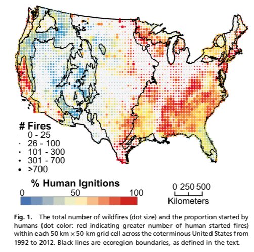
Comparing the numbers of human and lightning caused wildfires

During a 21-year period 84 percent of the wildfires in the United States were caused by humans, but the ratio varies greatly across the country.

lighting human caused wildfires

A study published by the National Academy of Sciences looked at the causes of wildland fires, human vs. lightning, and their occurrence geographically and seasonally. The researchers analyzed 1.5 million fire occurrence records from 1992 to 2012.

I was interested in reading the paper after having been attracted to the compelling graphics comparing the numbers of fires caused by humans and lighting, ecoregion by ecoregion over time.

The research was conducted by Jennifer K. Balch, Bethany A. Bradley, John T. Abatzogloue, R. Chelsea Nagy, Emily J. Fusco, and Adam L. Mahood.

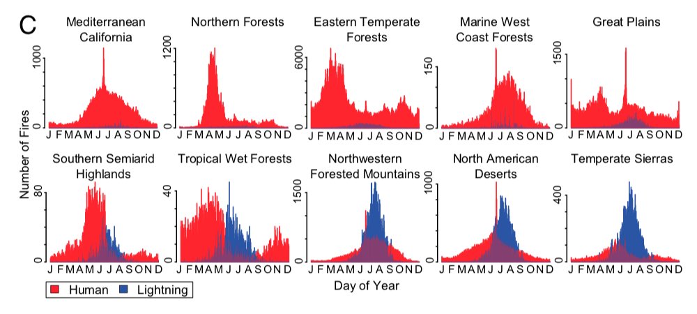
lighting human caused wildfires
Frequency distributions of wildfires by ecoregions, ordered by decreasing human dominance. Click to enlarge.

You might have noticed a large short-lived spike in the number of human caused fires in several of the ecoregions around June-July. That represents ignitions caused by fireworks on the Fourth of July.

Below is an excerpt from the research:


“In conclusion, we demonstrate the remarkable influence that humans have on modern United States wildfire regimes through changes in the spatial and seasonal distribution of ignitions. Although considerable fire research in the United States has rightly focused on increased fire activity (e.g., larger fires and more area burned) because of climate change, we demonstrate that the expanded fire niche as a result of human-related ignitions is equally profound. Moreover, the convergence of warming trends and expanded ignition pressure from people is increasing the number of large human-caused wildfires. Currently, humans are extending the fire niche into conditions that are less conducive to fire activity, including regions and seasons with wetter fuels and higher biomass.

“Land-use practices, such as clearing and logging, may also be creating an abundance of drier fuels, potentially leading to larger fires even under historically wetter conditions. Additionally, projected climate warming is expected to lower fuel moisture and create more frequent weather conditions conducive to fire ignition and spread, and earlier springs attributed to climate change are leading to accelerated phenology. Although plant physiological responses to rising CO2 may reduce some drought stress, climate change will likely lead to faster desiccation of fuels and increased risk in areas where human ignitions are prevalent.”

(end of excerpt)


You can download the paper HERE (it is a large 13 Mb file).

Winners announced for contest to build deployable device to monitor wildfire smoke

Wildland fires produce significant air pollution, posing health risks to first responders, residents in nearby areas, and downwind communities.

The existing air quality monitoring hardware is large, cumbersome, and expensive, thereby limiting the number of monitoring stations and the data that is available to help officials provide appropriate strategies to minimize smoke exposure. They can’t be easily moved to the latest areas that are being affected by wildfire smoke.

Last year the Environmental Protection Agency in association with the U.S. Forest Service, National Park Service, and other agencies issued a Wildland Fire Sensors Challenge to spur the development of a transportable device that could measure some of the byproducts of combustion produced by vegetation fires. They offered prizes for the first and second place entries of $35,000 and $25,000.

The goal was a field-ready prototype system that could be set up near a fire that was capable of measuring constituents of smoke, including particulates, carbon monoxide, ozone, and carbon dioxide over the wide range of levels expected during wildland fires. It was to be accurate, light-weight, easy to operate, and capable of wireless data transmission, so that first responders and nearby communities have access to timely information about local air quality conditions during wildland fire events.

The winners have been announced:

Sensor Challenge Winners
EPA

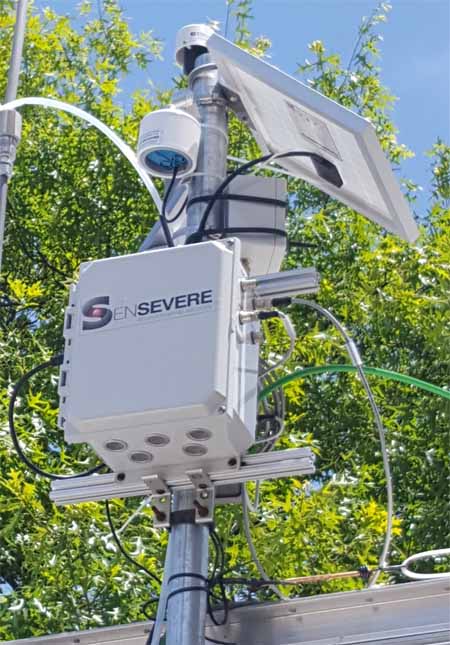
Jason Gu of SenSevere/Sensit, a co-developer of the first place winning system, said they have a number of units in the field now being tested under real world conditions. They also want to install them near existing air quality monitoring stations to ensure that the data from the new design is comparable to data from the old-school stationary equipment that has been used for decades. When they are satisfied with the results, manufacturing will be the next step.

smoke monitor air quality sensors
SenSevere/Sensit

The SenSevere/Sensit unit has a battery that can last for three weeks but will have a solar panel to keep it charged. The device can transmit the data via a cellular connection or a radio. All of the sensors are made by SenSevere/Sensit. Their smoke sensor uses a blower that pulls air through a filter which removes the larger particles, and then a light beam detects the remaining very small PM2.5 particles, the ones that can be ingested deep inside a person’s lungs.

The video below has more information.

FSU researchers: Most fires in Florida go undetected

By: Zachary Boehm

A new study by Florida State University researchers indicates that common satellite imaging technologies have vastly underestimated the number of fires in Florida.

Holmes Nowell
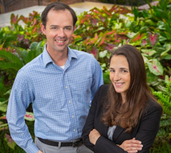
Christopher Holmes, assistant professor in the department of Earth, Ocean and Atmospheric Science, and Holly Nowell, postdoctoral researcher in EOAS.

Their report, published in collaboration with researchers from the Tall Timbers Research Station and Land Conservancy, challenges well-established beliefs about the nature and frequency of fire in the Sunshine State. While there were more fires than expected, researchers said, strategically prescribed burns throughout the state are proving an effective force against the ravages of wildfire.

The paper appears in the journal Geophysical Research Letters.

For scientists studying fire, sophisticated satellites whizzing far above the Earth’s surface have long represented the best tool for monitoring wildfires and prescribed burns — carefully controlled and generally small fires intended to reduce the risk of unmanageable wildfires.

But FSU researchers suggest that fire experts themselves have been getting burned by faulty data, and that broadly accepted estimates of fire area and fire-based air pollutants might be flawed.

“There are well-known challenges in detecting fires from satellites,” said lead investigator Holly Nowell, a postdoctoral researcher in the Department of Earth, Ocean and Atmospheric Science. “Here we show that only 25 percent of burned area in Florida is detected.”

Using comprehensive ground-based fire records from the Florida Forest Service — which regulates and authorizes every request for a prescribed burn in the state — researchers found dramatic discrepancies between fires detected by satellites and fires documented by state managers.

prescribed fire Florida
Austin Dixon of the Tall Timbers Research Station and Land Conservancy monitors a prescribed burn. Credit: Kevin Robertson

The majority of fires in Florida come in the form of prescribed burns, but because these fires are designed to be brief and contained, they often fall under the radar of satellites soaring overhead.

This is especially true in a state like Florida, where dense cloud cover is common and the warm, wet climate allows vegetation to regrow quickly after a blaze, disguising the scars that fires leave in their wake.

“Like a detective, satellites can catch a fire ‘in the act’ or from the ‘fingerprints’ they leave behind,” said study co-author Christopher Holmes, an assistant professor in EOAS. “In our area, catching an active fire in a thermal image can be hard because the prescribed fires are short, and we have frequent clouds that obscure the view from space.”

The state fire records also revealed a counterintuitive truth: Unlike in western states such as California, where dry conditions frequently produce massive increases in destructive and often uncontrollable fires, Florida actually experiences a decrease in land consumed by fire during drought.

When drought conditions emerge, researchers said, officials are less likely to authorize prescribed burns. And because prescribed burns account for the overwhelming majority of fires in the state, overall fire activity decreases.

This also suggests that prescribed burning programs — which aim to reduce the risk of wildfire in dry conditions — are having a materially positive effect.

“Although we still have occasional destructive wildfires, including the recent tragic Eastpoint fire, our results indicate that prescribed fire policy is helping to reduce wildfire risk,” Holmes said, referencing the June 2018 wildfire that destroyed dozens of homes in Florida’s Big Bend region.

Tall Timbers specialist Tracy Hmielowski uses a drip torch to ignite vegetation as part of a prescribed burn. Credit: Kevin Robertson
While the team’s study reconfirms the utility of prescribed burning, it calls into question prevailing estimates for airborne pollution from fire. If, as the study suggests, only 25 percent of fires in Florida are detected by satellites, then there could be “a rather large bias and a significant potential underestimation of emissions,” Nowell said.

The study’s findings are specific to Florida, but researchers suspect that similar satellite limitations may be skewing fire detection — and, consequently, emission estimates — in neighboring regions and geographically analogous areas like the savannas of Africa or the agricultural belts of Europe and Asia.

“We believe this result easily extends to the rest of the Southeast United States — which burns more area than the rest of the United States combined in a typical year — and other similar regions throughout the world that use small prescribed burns as a land management technique,” Nowell said.

Kevin Robertson, Casey Teske and Kevin Hiers from Tall Timbers contributed to this study. The research was funded by the National Aeronautics and Space Administration.

Thanks and a tip of the hat go out to Tom.
Typos or errors, report them HERE.

Study showed over a season smokejumpers lost muscle mass and often had impaired reaction time

Nine of them were monitored by University of Idaho researchers

firefighters wildfire smoke
Firefighters arrive at the White Tail Fire in South Dakota, March 8, 2017. Photo by Bill Gabbert.

(UPDATED December 2, 2018)

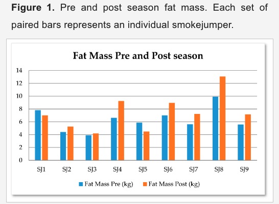
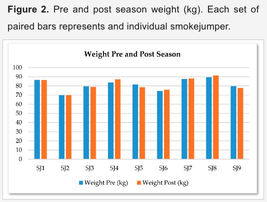
A copy of the full paper from the study is now available.  Here are a couple of figures from the document.

smokejumper study firefighters fat

smokejumper study firefighters weight


(Originally published September 2, 2018)

This study conducted by researchers at the University of Idaho followed 9 smokejumpers over the course of a fire season. This is not a representative sample of wildland firefighters and the many different jobs they perform, but it is interesting nonetheless. This year they are monitoring 18 additional smokejumpers and hope to expand it to more firefighters in the future.


University of Idaho study looks at firefighter diet, sleep in an effort to curb impaired work

By Sara Zaske, U. of I. College of Natural Resources

Wildland firefighters are working long shifts this summer all across the West. And they are getting really tired.

Randy Brooks knows exactly how tired. The University of Idaho professor is closely tracking 18 smokejumpers with the help of advanced motion monitors that use an algorithmic fatigue model originally developed for the U.S. military.

This is not just an academic exercise — Brooks is aiming to save lives.

“Wildland firefighters need to be alert and vigilant of their surrounding situation because something could happen at any moment,” he said.

Both of Brooks’ sons fight fires. And the need for great situational awareness hit close to home in 2015 when a fire shifted directions on one of his sons.

It started with a late-night text — his son, Bo Brooks, let him know the crew was heading to work the next day on the Twisp fire in north central Washington. He was nervous because high winds were forecast.

The next day, Brooks got a phone call instead of his typical text.

“My son called me at 4 in the afternoon,” Brooks said. “I knew something was wrong because they usually just text me to let me know they were all right.”

Randy BrooksThis time everything was not all right. The winds kicked up suddenly, and the fire crew had to “bug out” – run out of an area as quickly and efficiently as possible. Not all of them made it. Three firefighters died and another was badly burned.

After the tragedy, some members of the team quit firefighting. Bo Brooks stayed on but wanted things to change: “He said ‘Dad you’re a forestry researcher — is there anything you can do to help us?’” Randy Brooks said.

So Brooks, who works in U of I’s College of Natural Resources, and Callie Collins, a doctoral student in environmental science, conducted a survey of more than 400 wildland firefighters. The majority indicated that the main contributors to accidents in fire operations were inadequate sleep and fatigue, both mental and physical.

The researchers followed the survey with a pilot study of nine firefighters to closely assess sleep, fatigue and body composition.

They outfitted the smokejumpers, firefighters who parachute from planes to battle wildland fires in remote areas, with Readibands — motion monitors made by Fatigue Science that keep detailed data on sleep and activity. The data was then analyzed using the algorithm model developed by the U.S. Army Research Laboratory to obtain an “alertness score,” which quantifies the wearers’ reaction times and relative accident risk.

In the pilot study, Brooks and Collins found firefighters spent more than 42 percent of one month working in impaired conditions with reaction times slowed by as much as 34 to 100 percent – equivalent to having a blood-alcohol concentration of 0.05 to 0.11 or higher. That’s on the cusp of the legal limit for driving at 0.08.

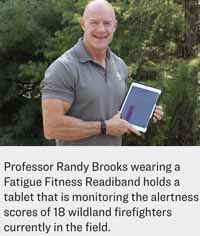
Professor Randy Brooks wearing a Fatigue Fitness Readiband holds a tablet that is monitoring the alertness scores of 18 wildland firefighters currently in the field.

The researchers also had the firefighters’ body composition measured, before and after the fire season, and looked at their hydration and diet. Despite their high level of physical activity, the smokejumpers maintained their weight but gained fat over the summer — and lost muscle mass.

Brooks and Collins believe this may be because of the quality of their diet, which is high in carbohydrates and sugar and lower in protein and healthy fats like those found in eggs, nuts and fish. They hope to test that hypothesis in future studies.

Always a challenging profession, wildland firefighting has become even more difficult in recent years as the wildfire season in the West continues to grow in intensity and duration – today the fire season is about 30 days longer than it was three decades ago.

“It’s like they used to be running a 100-yard dash 30 years ago and now they’re running a marathon with the longer fire seasons,” Brooks said.

And if they are running a firefighting marathon, he argues, the crews may need to eat and drink like elite athletes do as well.

This summer, Brooks doubled the sample size of his pilot study to 18 smokejumpers. He wants to expand the project further in the future, and nearly 200 firefighters have volunteered to participate in his studies. His research was only limited by the expense of the motion trackers, which cost close to $1,000 each at the start of the study.

Still, Brooks hopes whatever data he gathers will help make this dangerous profession safer.

“I think we need a paradigm shift in the way we think about fighting wildfires at all cost and place a greater emphasis on personal safety over protecting resources,” Brooks said. “Trees grow back, homes can be rebuilt, but lives can’t be replaced.”


Engineer who worked on plans for nuclear-powered airplane later developed the fire spread model

Throwback Thursday: the origin of the model for predicting the spread of wildland fires

Today we may take it for granted that tools are available that can estimate how a fire, unplanned or prescribed, will spread across a landscape. It is not an exact science because there are far too many variables than can realistically be accounted for, at least with the technology available today. But in 1972 when Dick Rothermel and others developed the Forest Service’s first quantitative, systematic tool for predicting the spread and intensity of forest fires, it introduced a new era in fire management. And surprisingly, it is still the main tool being used today. Many researchers have produced alternative models, but none have made it into the hands of firefighters on a widespread basis.

Dick Rothermel fire research Ember Award
For his research and contributions to understanding how fires spread, Dick Rothermel was given the Ember Award at caonference in Missoula in 2014. Photo by Bill Gabbert.

After Mr. Rothermel developed the mathematical model, others used the information to make the concept more user-friendly and to analyze complex scenarios. Behave, software burned onto a custom made chip in a hand-held Texas Instruments 51 calculator, and later BehavePlus for personal computers, became must-have tools for fire behavior analysts. FARSITE added the ability to predict spread across variable terrain, vegetation, and weather. Rare Event Risk Assessment Process (RERAP) estimates the risk that a fire will reach a particular place before it dies. FireStem estimates tree mortality based on fire behavior and intensity. And there are many others.

When Mr. Rothermel began researching the behavior of wildland fires, he had just been downsized from a shuttered Department of Defense program that had been attempting to develop a nuclear-powered airplane.

Below is an excerpt from an excellent article by Gail Wells for the March, 2008 edition of Fire Science Digest, a publication of the Joint Fire Science Program.


[Jack] Barrows, [the first director of the fire laboratory in Missoula when it opened in 1960], went looking for researchers. He learned that General Electric was closing a laboratory in Idaho Falls where engineers had been working on a defense project to develop a nuclear-powered airplane. The government scrapped the program in 1961, and a handful of highly trained engineers and scientists were suddenly up for grabs.

“GE wanted to see that we got as good a placement as we could,” Rothermel recalls. “So we all wrote resumes, and Jack got hold of these, and he said it was like a Sears and Roebuck catalog of people.” Barrows hired four of the GE scientists: Hal Anderson, a physicist; Stan Hirsh, an electrical engineer; Eric Breuer, a technician; and Dick Rothermel.

Their hiring represented a departure from Forest Service custom. Up until that time, fire research had been pretty much the domain of foresters, who are used to looking at their work through the lenses of biology and silviculture. Gisborne was a forester; Barrows was a forester. But Barrows recognized that fire is a physical process, and that physical scientists and engineers could contribute much to the emerging science of fire behavior.

Rothermel, then barely into his 30s, was glad to join Barrows’s staff. He had a bachelor’s degree in aeronautical engineering from the University of Washington. During the 8 years since he’d graduated, he had worked in the engineering of nuclear systems in Albuquerque and then in Idaho. (Rothermel later went on for a master’s degree in mechanical engineering from Colorado State University.)

“I had the option of staying on [at GE] and working on a lot of programs, but with the cancellation of the atomic-powered airplane, nothing sounded that appealing,” he says. “And then I heard about this laboratory, and they said they had two wind tunnels and a combustion lab where you could control the atmosphere, temperature, and humidity. I thought, “Wow, that’s an opportunity!” Rothermel worked with Hal Anderson to get the new lab’s equipment calibrated and running smoothly. Then they began a set of experiments in the wind tunnel and combustion chamber, testing the effects of wind and moisture on various fuels and determining how fast a fire would spread under different conditions.

[…]

Given their training, it made sense to Rothermel and Anderson to approach the task as an engineering problem. Says Rothermel: “The idea was, if we could develop a way of describing the fuels, the weather, the topography, and something about the fire, and be able to put that into what we call a mathematical model, and if we described all these things properly, the model would integrate it and produce answers. It would tell you the resulting fire intensity, rate of spread, flame length, these sorts of things.”

Rothermel, Anderson, and Bill Frandsen, another physicist on the project, adapted an approach developed by an early Forest Service fire researcher, Wally Fons, which turned on the concept of conservation of energy. A fire spreads by igniting a series of little fires in the fuel ahead of it. The ignitions are driven by convection, radiation, and conduction. Even if it’s unknown which mode is operating in a given instance, the rate of heat transfer can be measured. The researchers reasoned that if they knew how much fuel was ahead of a fire, how big and how densely packed the fuel particles were, and how much moisture the fuel contained, then they could figure out how much energy would be needed to transfer enough heat to bring the fuel up to the ignition point. They could then calculate the rate of ignition that would carry the fire as it spread. The model would also have to account for the critical variables of wind speed and slope of the ground.

Because of the limitations of wind tunnels and combustion chambers, the model is forced to make certain assumptions that don’t hold in real life. For example, it assumes that the fuel is continuous and evenly distributed and burns uniformly. It further assumes that the fire is carried primarily by dead plant material and that only moisture will stop it.

The Rothermel model “describes very well a fire burning in a field of wheat,” says Bret Butler, a mechanical engineer at the Fire Sciences Lab whom Rothermel hired in 1992. “As you get further away from that uniformity, the less accurate it becomes.”

More significantly, the researchers had no basis for modeling the endless spatial variability that actually exists in a forest. So there was no way to simulate a fire’s movement through clumpy, discontinuous trees and shrubs. There was also no way to model a crown fire, one that leaves the surface and moves up into the crowns of trees. These were significant and universally acknowledged shortcomings.

Fire research scientists throughout the world are working on developing more accurate surface-fire spread models, but at this point all of them are too complicated to be used in an operational system. The beauty of Rothermel’s model, says Butler, “is that it’s simple—it can be run quickly with a low-capability computer.”

(end of excerpt)


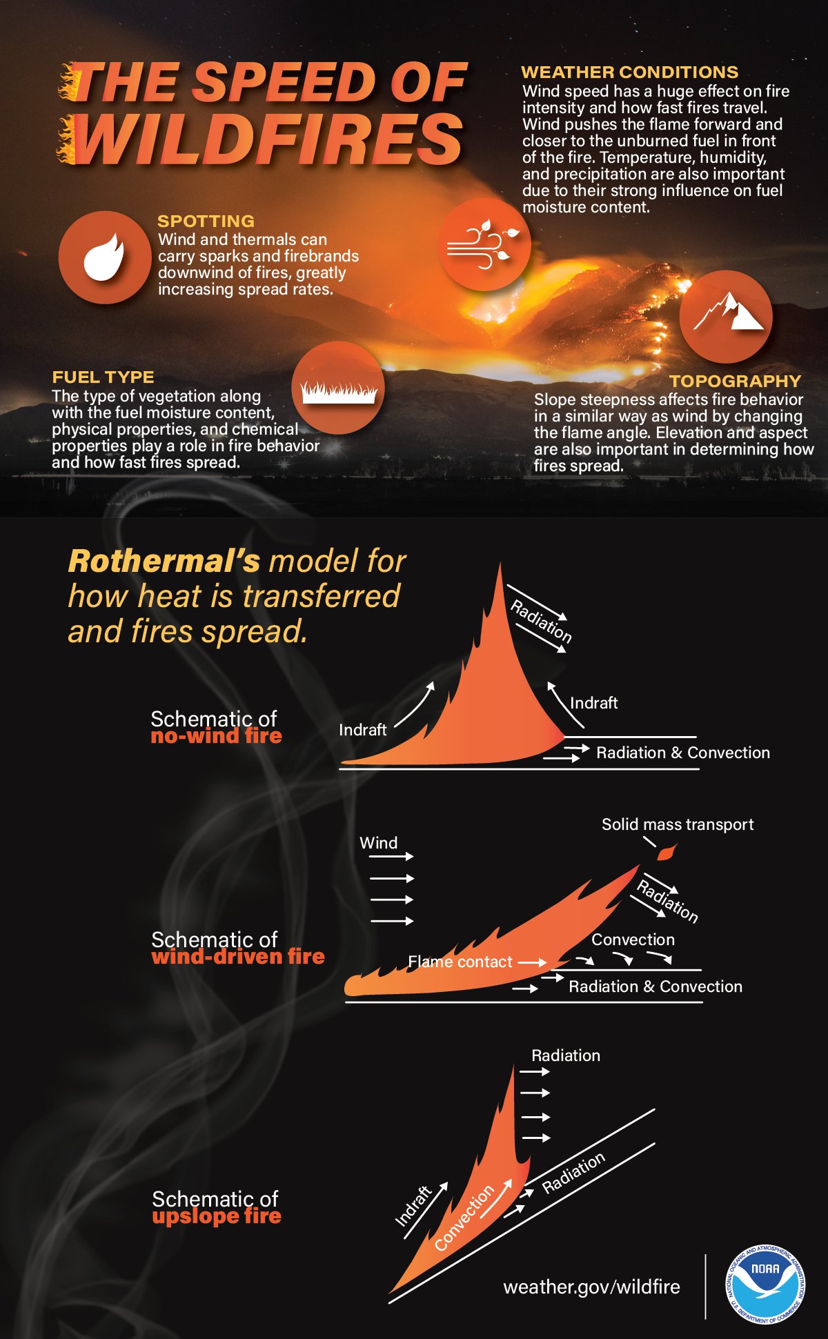
What made me think of Mr. Rothermel was a graphic distributed on Twitter today by the National Weather Service. It is a fancy, colorized version of the figure in his 1972 paper that depicts how heat is transferred in a fire.

wildfire research dick rothermel
Graphic distributed by @NWS that is based on Dick Rothermel’s 1972 paper.

But of course Mr. Rothermel’s contributions are far more complex than this graphic.

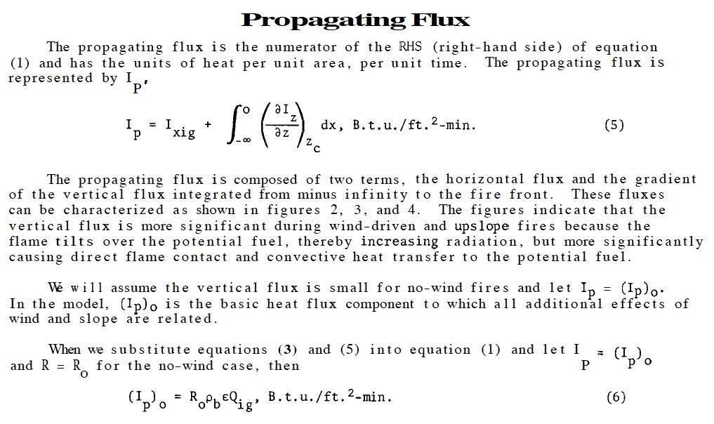
Below is a screenshot from his paper where he describes Propagating Flux, just one of many elements of his mathematical fire spread model.

rothermel propagating flux

And here is his summary of equations for the model:

Summary equations Rothermel's 1972 paper fire model
Summary of equations from Rothermel’s 1972 paper.

Epilogue 1: The current administration has expressed a desire to zero-out the budget for the Joint Fire Science Program, the organization that published the 2008 article. 

Epilogue 2: Mr. Rothermel was one of the 655 attendees at the Fire Continuum Conference in Missoula last month.