Can technology determine the best escape route for firefighters?

Of the 22 research proposals funded by the Joint Fire Science Program in June, 16 of them were various ways of studying vegetation. At the time we wrote, “It would be refreshing to see some funds put toward projects that would enhance the science, safety, and effectiveness of firefighting.”

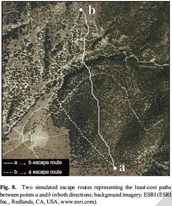
A recently completed study is directed toward the firefighters on the ground. The U.S. Forest Service has paid to have researchers study the feasibility of using LiDAR and computers to determine the most efficient and quickest escape routes if firefighters have to withdraw while attacking a wildfire. The LiDAR helped researchers evaluate how landscape conditions, such as slope, vegetation density, and ground surface roughness affect travel rates.

I have a feeling that there will have to be significant advances in portable handheld technology before fire crews in remote areas can take advantage of this type of data. However, who knows, maybe in 10, 20, 30, or 40 years grunts on the ground will have access to sophisticated tools that we can’t even imagine today. They might just speak into a lapel pin to ask for the best escape route, and an augmented reality head-up display or an orbiting drone with a visible laser will designate the path.

Even though the research was paid for by United States taxpayers through the U.S. Forest Service, those same taxpayers will be charged a second time if they want to see the full results of their investment. The fee is $25 to get a copy of the .pdf. It may be available months or years down the road at no additional cost.

The title of the paper is, A LiDAR-based analysis of the effects of slope, vegetation density, and ground surface roughness on travel rates for wildland firefighter escape route mapping.

A year ago the same group of researchers studied how to find and evaluate safety zones in a paper titled, Safe separation distance score: a new metric for evaluating wildland firefighter safety zones using lidar. This research IS accessible to taxpayers without paying a second time.

The recent paper about escape routes was written by Michael J. Campbell, Philip E. Dennison, and Bret W. Butler. Here is a summary of some of their findings.


Every year, tens of thousands of wildland firefighters risk their lives to save timber, forests and property from destruction. Before battling the flames, they identify areas to where they can retreat, and designate the best escape routes to get from the fire line to these safety zones. Currently, firefighters make these decisions on the ground, using expert knowledge of fire behavior and assessing their ability to traverse a landscape.

Now, a University of Utah-led study has developed a mapping tool that could one day help fire crews make crucial safety decisions with an eagle’s eye view.

The new study is the first attempt to map escape routes for wildland firefighters from an aerial perspective. The researchers used Light Detection and Ranging (LiDAR) technology to analyze the terrain slope, ground surface roughness and vegetation density of a fire-prone region in central Utah, and assessed how each landscape condition impeded a person’s ability to travel.
Escape Route wildfire“Firefighters have a great sense for interactions between fire and landscape conditions. We hope to offer to them an extra tool using information collected on a broad scale,” says lead author Michael Campbell, doctoral candidate in the U’s Department of Geography.

Department of Geography professor and co-author, Philip Dennison, adds, “Finding the fastest way to get to a safety zone can be made a lot more difficult by factors like steep terrain, dense brush, and poor visibility due to smoke. This new technology is one of the ways we can provide an extra margin of safety for firefighters.” Continue reading “Can technology determine the best escape route for firefighters?”

Facebook can be more useful than satellite data for tracking wildfire smoke

facebook wildfire smoke
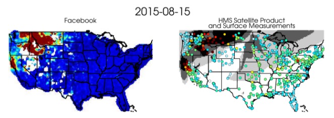
An illustration of Facebook users posting about wildfire smoke (indicated by red, yellow and orange). These posts are compared with standard satellite measurements of smoke in the atmosphere, and surface measurements of particles (colored circles), during August 2015. Credit: Bonne Ford.

By Ann Manning, Colorado State University

When people see smoke on the horizon, what do they do? Besides (hopefully) calling fire authorities, they post to social media, of course. The fact that people reliably flock to social media to discuss smoke and fire was the inspiration for a new study by Colorado State University atmospheric scientists. Driven to innovate ways to improve the air we breathe, the scientists have shown that social media, Facebook in this case, could prove a powerful tool.

A study in Atmospheric Chemistry and Physics led by research scientist Bonne Ford, who works in the lab of Associate Professor Jeff Pierce, shows striking correlation between numbers of Facebook users posting about visible smoke, and commonly used datasets for estimating harmful smoke exposure. These include satellite observations, chemical transport models and surface particulate matter measurements.

In fact, they found that Facebook did a better job pinpointing smoke exposure than satellite data, which takes pictures of smoke from above Earth.

“We have monitoring systems, but monitors can be sparse in different places,” Ford said. “In our group, we’ve been trying to combine a whole bunch of methods, models and observations to look at smoke exposure. And we thought, ‘it would be really great if people could just tell us when they are exposed to smoke. Well, what about social media?’”

The idea for the Facebook study grew out of an interdisciplinary meeting in 2015. Organized by CSU Distinguished Professor A. R. Ravishankara of the Department of Chemistry, the meeting convened regional scientists, government officials and emergency management authorities working to improve smoke monitoring.

Anonymous Facebook posts
Partnering with a research scientist at Facebook – paper co-author Moira Burke – the scientists culled de-identified, city-level aggregated Facebook data across the U.S. and Canada during the period of June 5-Oct. 27, 2015. They counted Facebook users who posted about wildfire smoke, using, for example, terms like “haze,” “smoke” and “fire,” but not “cigarette.” These posts were counted automatically at the city level; researchers did not read any individuals’ posts. Thus Facebook was the ideal test case for tracking when and where people posted about fires in their area, without identifying who was posting.

The researchers made daily maps that counted Facebook posts and compared them with data maps of standard smoke monitoring systems. They found strong correlation particularly with surface monitors, which sense airborne particulate matter with diameters of 2.5 microns or less, so-called “PM2.5” which is a standard measure of smoke and other inhalable particles in the air. Breathing PM2.5 particles is considered to have potential health ramifications, which is why scientists are interested in studying their whereabouts and impacts.

Pierce said that while satellites see smoke from above, the data can mislead. “Sometimes, the satellites can’t tell what altitude the smoke is at,” he said.

New methods
They hope their study could be useful in thinking about new methods to assess smoke exposure, and thus, provide better beacons for health risks assessment, Ford said. “We’re going to work on seeing if we can use this Facebook data to improve exposure estimates we’re already doing.”

Pierce and Ford collaborate with others across campus in the Partnership for Air Quality, Climate and Health, a union of multidisciplinary researchers working to assess air pollution and improve air quality.

Thanks and a tip of the hat go out to Allen.
Typos or errors, report them HERE.

Research projects funded by Joint Fire Science Program concentrate on vegetation

Joint Fire Science ProgramThe Joint Fire Science Program announced on Friday which research projects are being funded for fiscal year 2017. Of the 22 approved proposals, about 16 of them are various ways of studying vegetation.

It would be refreshing to see more funds put toward projects that would enhance the science, safety, and effectiveness of firefighting.

Click HERE to see the list of approved research projects.

USGS to study fuel break effects on wildfires, sage-grouse

Above: Roads through areas prone to wildfire act as fuel breaks, disrupting the fuel continuity, potentially reducing the rate of fire spread. The areas on either side of the road have also been mowed to reduce vegetation height. Photo courtesy of BLM.

The U.S. Geological Survey is gearing up for a project across the Great Basin studying how effective fuel breaks are, simultaneously evaluating their ecological costs and benefits.

Fuel breaks like sandy roads or other barriers are intended to reduce fire size and frequency by slowing or altogether halting fire’s spread to the other side of the break. Still, questions remain about whether fuel breaks protect sagebrush and sage-grouse, the USGS said in a comments discussing the new research. 

“We want to determine the extent to which fuel breaks can help protect existing habitat from wildland fires, paying particular attention to how such breaks affect sagebrush habitat, sage-grouse, and other sagebrush-dependent species,” the USGS said in a statement. 

Additional information about the research can be found on the USGS site. 

Researchers testing fire shelter prototypes on South Dakota prescribed burns

Above: Left to right: Bobby Williams, Nick Mink/BLM, Blake Stewart/USFWS, and Joe Roise inspect the fire shelter model currently used by firefighters, which was included in the field test for comparative purposes. Photo courtesy  Great Plains Fire Management Zone 

North Carolina State University researchers this week began field testing new fire shelter prototypes during prescribed fire operations in South Dakota.

About a year after the deaths of 19 Granite Mountain Hotshots from the 2013 Yarnell Hill Fire, the U.S. Forest Service entered into a collaborative agreement with the NASA Langley Research Center. The goal: to examine potential improvements to fire shelter performance. University researchers also received a FEMA Assistance to Firefighters Grant to develop new material that improved existing fabric technology and enhanced current fire shelters.

Researchers from North Carolina State’s College of Textiles worked with the Department of Forestry and Environmental Resources to study and offer up potential improvements. 

Until this week, those efforts were generally confined to the university’s lab. But researchers joined an East River Fire Training Exchange training crew for burn operations in eastern South Dakota to test a new fire shelter prototype.

“The whole project is extremely important because it can save lives across the nation,” Professor Joe Roise said in a news release, posted to InciWeb. “That’s the bottom line: saving lives.”

North Carolina State University Joe Roise (foreground) and Bobby Williams (background) set up their fire shelter test site within the Eyecamp prescribed fire area. The sensor poles shown here measure and record the temperature at 2, 4, 6, and 8 feet in height as the fire passes through the area. Photo courtesy Great Plains Fire Management Zone.

Operations are taking place this week in the Madison Wetland Management District.

Field testing is likely to continue in coming weeks and months. The shelter models will be tested in fires on Virginian marshland, north Florida pine forests and timber throughout Canada’s Northwest Territories.

Burn Boss Blake Stewart/USFWS (left) and Firing Boss Nick Mink/BLM (right) walk out to the fire shelter test site after the fire has passed.
Burn Boss Blake Stewart/USFWS (left) and Firing Boss Nick Mink/BLM (right) walk out to the fire shelter test site after the fire has passed. Photo courtesy Great Plains Fire Management Zone.


EPA wants to develop low-cost sensor system to monitor smoke

EPA wildfire smoke sensor challengeThe Environmental Protection Agency has announced an initiative to develop a new low-cost system that could monitor air quality affected by smoke from wildland fires. The existing hardware is large, cumbersome, and expensive, thereby limiting the number of monitoring stations and the data that is available to help officials provide appropriate strategies to minimize smoke exposure.

Below is an excerpt from the EPA’s announcement about what they call the Wildland Fire Sensors Challenge. The three graphics were part of the agency’s news release.

Today, emerging technologies – including miniaturized direct-reading sensors, compact/powerful microprocessors, and wireless data communications – offer the opportunity to develop new systems to quickly gather and communicate air pollution data.EPA wildfire smoke sensor challenge

Wild fires are increasingly common events that produce significant air pollution, posing health risks to first responders, residents in nearby areas, and downwind communities. Also, wild fires are increasing in frequency and intensity, and the fire season is growing longer.  Prescribed fires, which are used to manage ecosystems or reduce risk of wild fires, are typically managed to minimize downwind impacts on populated areas; however, people in close proximity may still be exposed to smoke.  The description “wildland fires” refers to both wild and prescribed fires.

This challenge seeks a field-ready prototype system capable of measuring constituents of smoke, including particulates, carbon monoxide, ozone, and carbon dioxide, over the wide range of levels expected during wildland fires. The prototype system should be accurate, light-weight, easy to operate, and capable of wireless data transmission, so that first responders and nearby communities have access to timely information about local air quality conditions during wildland fire events.

EPA cooperators

The EPA is partnering with several agencies to develop this equipment: Forest Service, National Park Service, National Oceanic and Atmospheric Administration, National Aeronautics and Space Administration, and Centers for Disease Control and Prevention.

However, with the current Administration’s intended massive cutbacks to the EPA and even scattered calls to eliminate the agency, finding the money and staff to bring this idea to fruition is anything but a slam dunk.