Very high to extreme fire danger in store for parts of California Sunday through Tuesday

October 24, 2020   |   6:46 p.m. PDT
Extreme fire danger
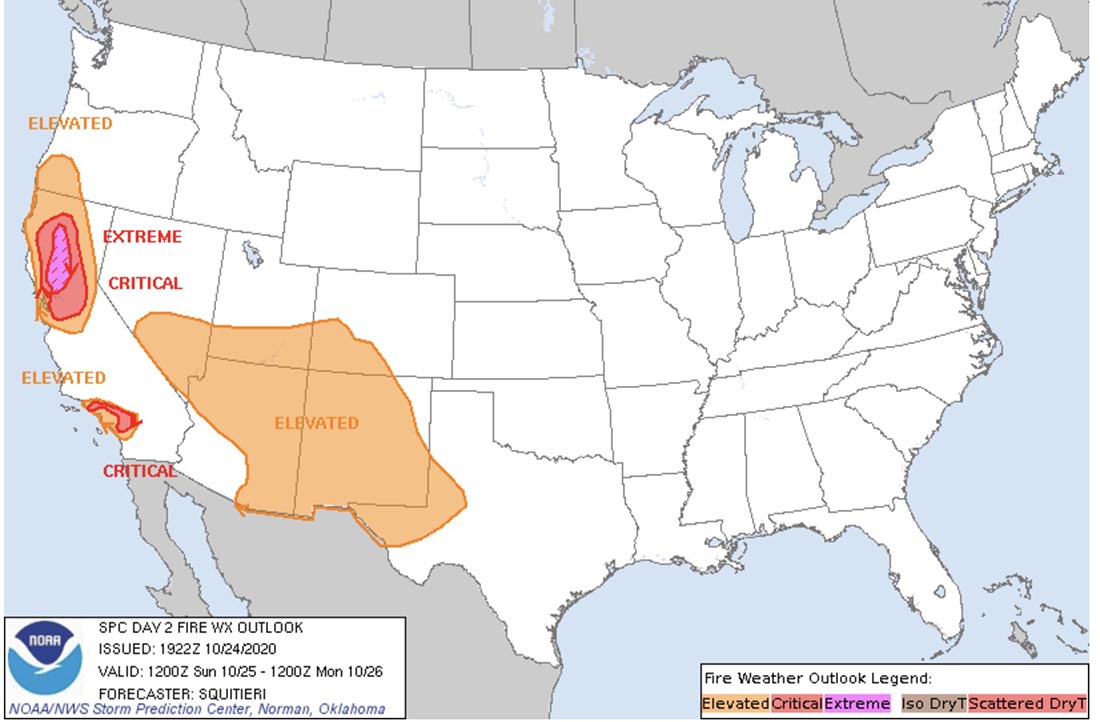
Storm Prediction Center forecast for Sunday. Extreme fire danger.

A major weather event that will affect wildland fire danger begins in California Sunday morning. NOAA’s Storm Prediction Center does not often predict extreme fire weather, but they have done just that to warn of a wind event with very low humidities for parts of California Sunday through Tuesday. At times the wind will be very strong and the relative humidity will drop below five percent in some locations.

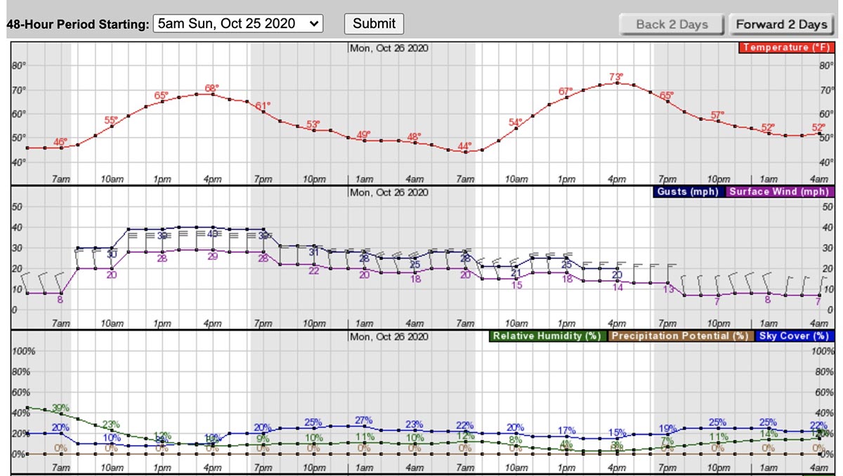
Check out the forecast for Red Bluff in Northern California —  on Sunday, 29 mph north winds with gusts to 40, and 10 percent relative humidity. On Monday, 18 gusting to 25 with 5 percent RH.
Weather forecast for Red Bluff, CA
Weather forecast for Red Bluff, CA Sunday and Monday

The extreme weather will begin in Northern California on Sunday then work its way to the southern part of the state on Monday and Tuesday.
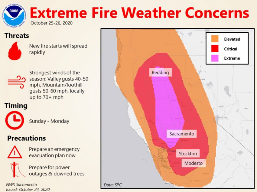
Fire weather Sunday and Monday
Fire weather Sunday and Monday, Northern California

The forecast for Riverside in Southern California beginning early Monday morning: 26 to 30 mph north winds gusting to 45, with 8 percent RH; then Tuesday, 18 to 20 mph gusting to 30 with 10 percent RH.

Weather Forecast Riverside, CA
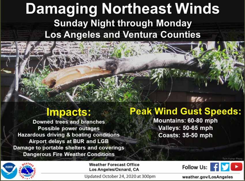
Fire weather Sunday and Monday
Fire weather Sunday and Monday Los Angeles and Ventura Counties.

With five to nine inches of snow beginning tonight on three fires in Colorado, I wonder if they can spare any crews or overhead personnel in case they are needed in California? Of course the 192,000-acre East Troublesome Fire after burning for 11 days only has 5 crews and 336 personnel, but the 206,000-acre Cameron Peak Fire next door has 42 crews and 1,903 personnel. The 10,000-acre Calwood Fire that has not spread for days now has snow, 10 crews, and 495 personnel. The National Multi-Agency Coordinating Group may have already made decisions along these lines.

As we wrote earlier today, of the 113 Interagency Hotshot Crews in the U.S., only about 35 are still funded and available for fighting fire. In two weeks that number drops to around 13 according to projections in a September 30, 2020 planning document compiled by an Area Command Team (ACT).

Wetter conditions in Australia may lead to a fire season very different from a year ago

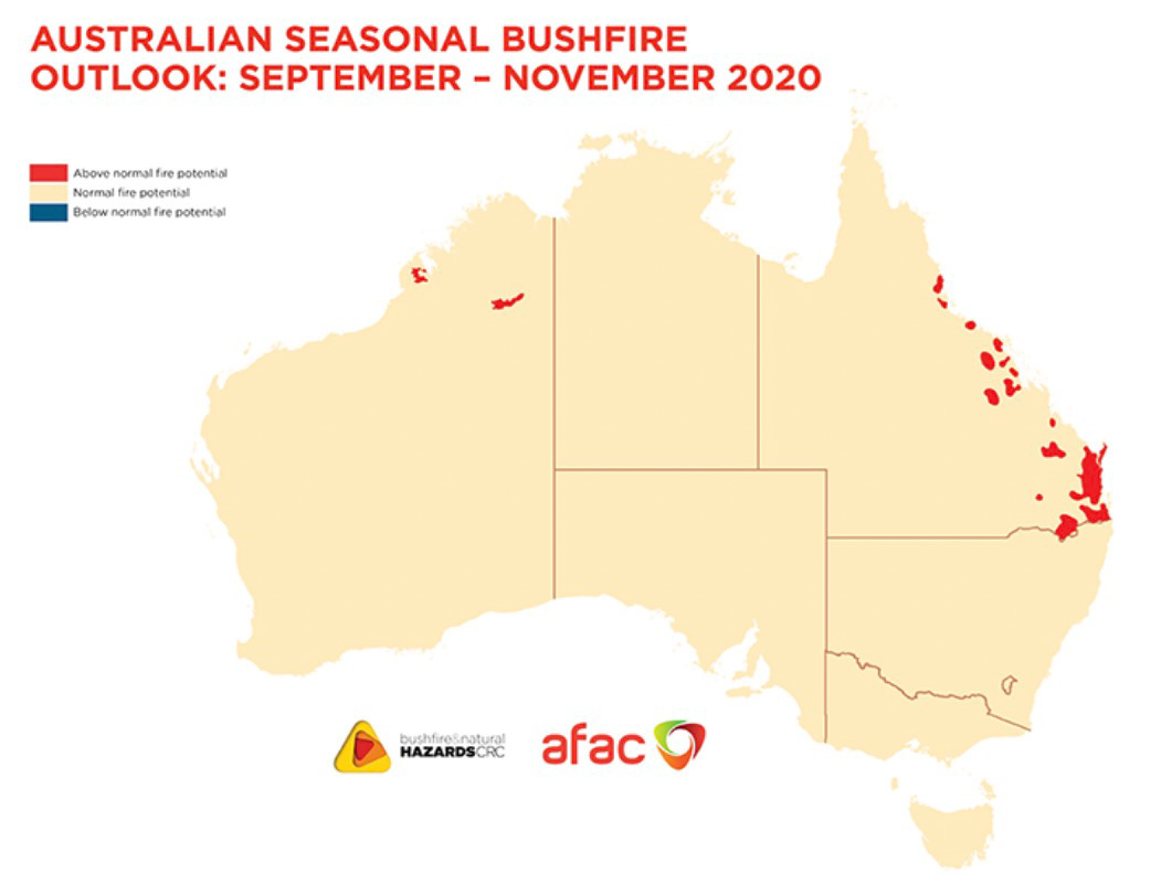
Australia fire outlook September through November, 2020

The 2020/21 fire season will be influenced by vastly different climate drivers than the previous two fire seasons, according to a September through November outlook from the Bushfire and Natural Hazard Cooperative Research Centre.

With a La Niña ALERT now active, large areas of eastern and northern Australia are expecting wetter than average conditions through spring. Despite the wetter climate signals, parts of Queensland face above normal fire potential in the south east and central coast, extending to the north.

While these wetter conditions in eastern Australia will help in the short-term, they may lead to an increase in the risk of fast running fires in grasslands and cropping areas over summer.

In contrast to the wetter conditions for the east, dry conditions persist in Western Australia, with above normal fire potential continuing to be expected in parts of the north.

Australia temperature outlook, October through December, 2020


Australia precipitation outlook October through December, 2020


Australia plans on having six large air tankers available during the 2020-2021 bushfire season.

California to face elevated wildfire danger again this week

Fire Weather Watch for Northern California and heat advisory for the southern part of the state

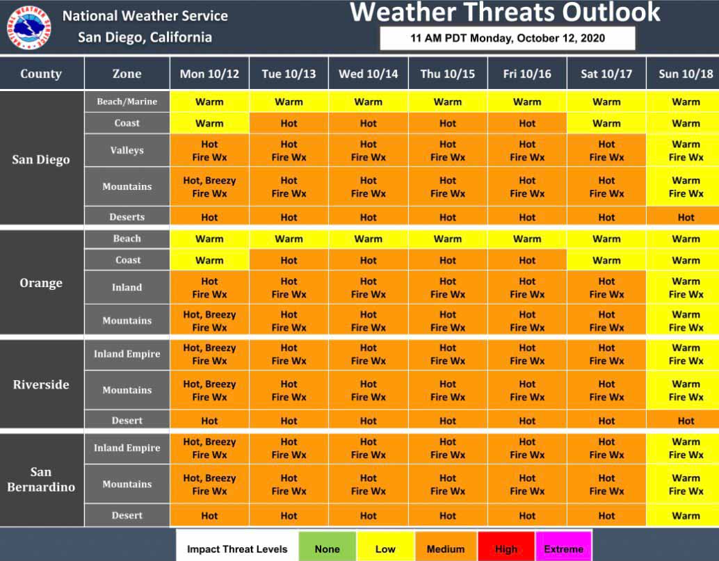
Southern California fire weather this week
Southern California fire weather this week. NWS.

Firefighters in California could face another round of wildfires this week as the weather turns hot, dry, and windy in some locations.

In Southern California a heat advisory has been issued for Tuesday through Friday for highs in the lower elevations approaching 100 degrees.

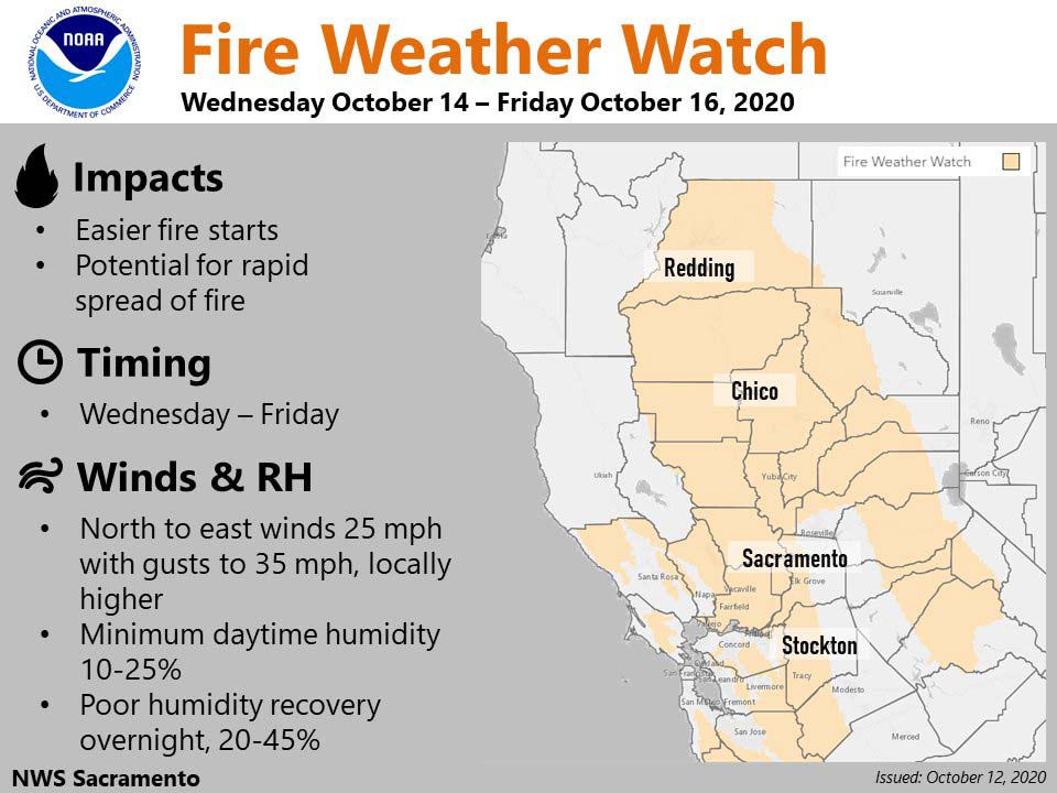
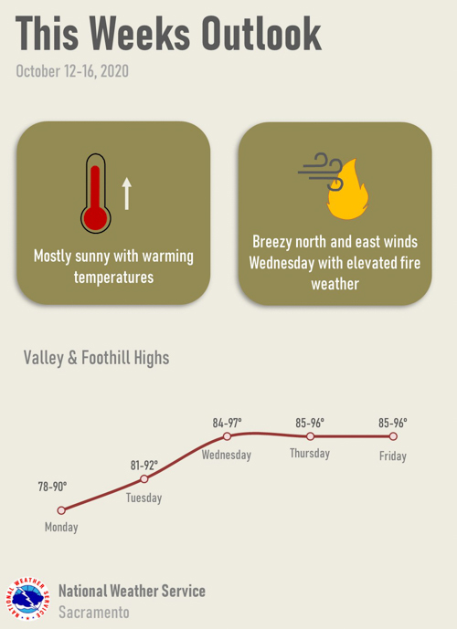
A Fire Weather Watch for Northern California is in effect Wednesday through Friday for breezy conditions, with the strongest winds expected Wednesday and Thursday.

There is a possibility of electrical power being preemptively being shut off by PG&E due to windy and dry conditions.

Possibility of electrical power being preemptively being shut off
Possibility of electrical power being preemptively being shut off this week by PG&E due to windy conditions.
Northern California fire weather this week
Northern California Fire Weather Watch this week.
Sacramento area fire weather this week
Sacramento area fire weather this week. NWS.

Outlook for October — high wildfire potential for much of the West

The fire forecast through January has been released

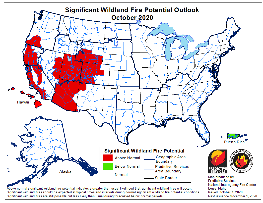
wildfire potential for October, 2020

The National Significant Wildland Fire Potential Outlook issued October 1 by the Predictive Services section at the National Interagency Fire Center predicts higher than average wildfire potential in October for portions of Oregon, Wyoming, Colorado, Arizona, Nevada, and most of California.

The data from NIFC shown here represents the cumulative forecasts of the ten Geographic Area Predictive Services Units and the National Predictive Services Unit.

Below:

  • An excerpt from the NIFC narrative report for the next several months;
  • More of NIFC’s monthly graphical outlooks;
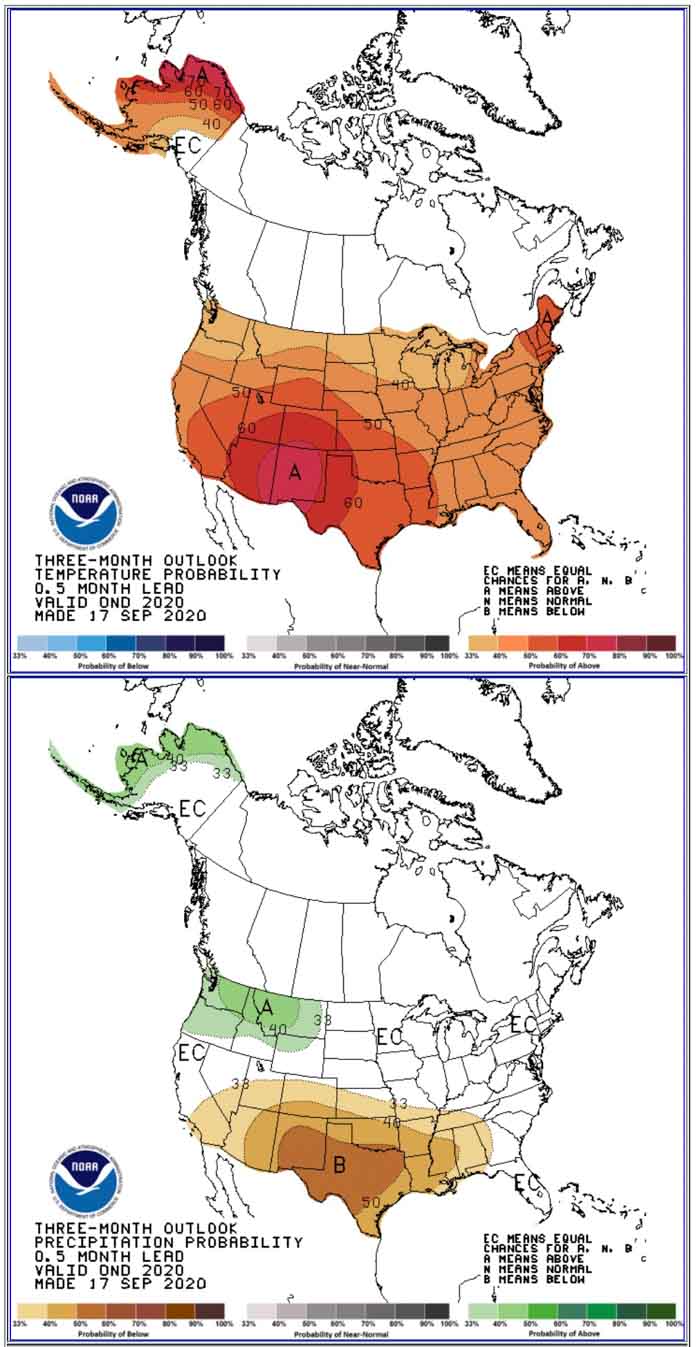
  • NOAA’s three-month temperature and precipitation forecasts;
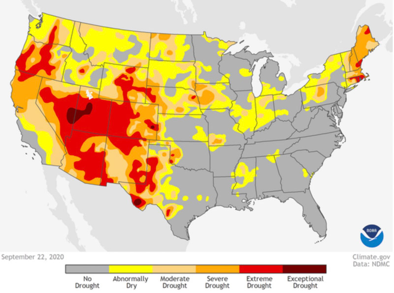
  • Drought Monitor;
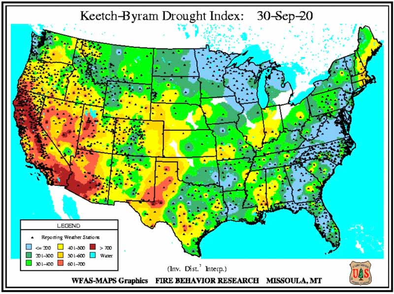
  • Keetch-Byram Drought Index.

“La Niña and current fuel conditions are the main drivers of significant fire potential through fall and into winter. Drought conditions are expected to continue for much of California, the Great Basin, and the Southwest through October with drying expected to increase across portions of the southern Plains and Southeast. Significant fire potential remains above normal for California due to the number of active large fires, near record dry fuels, and offshore wind events.

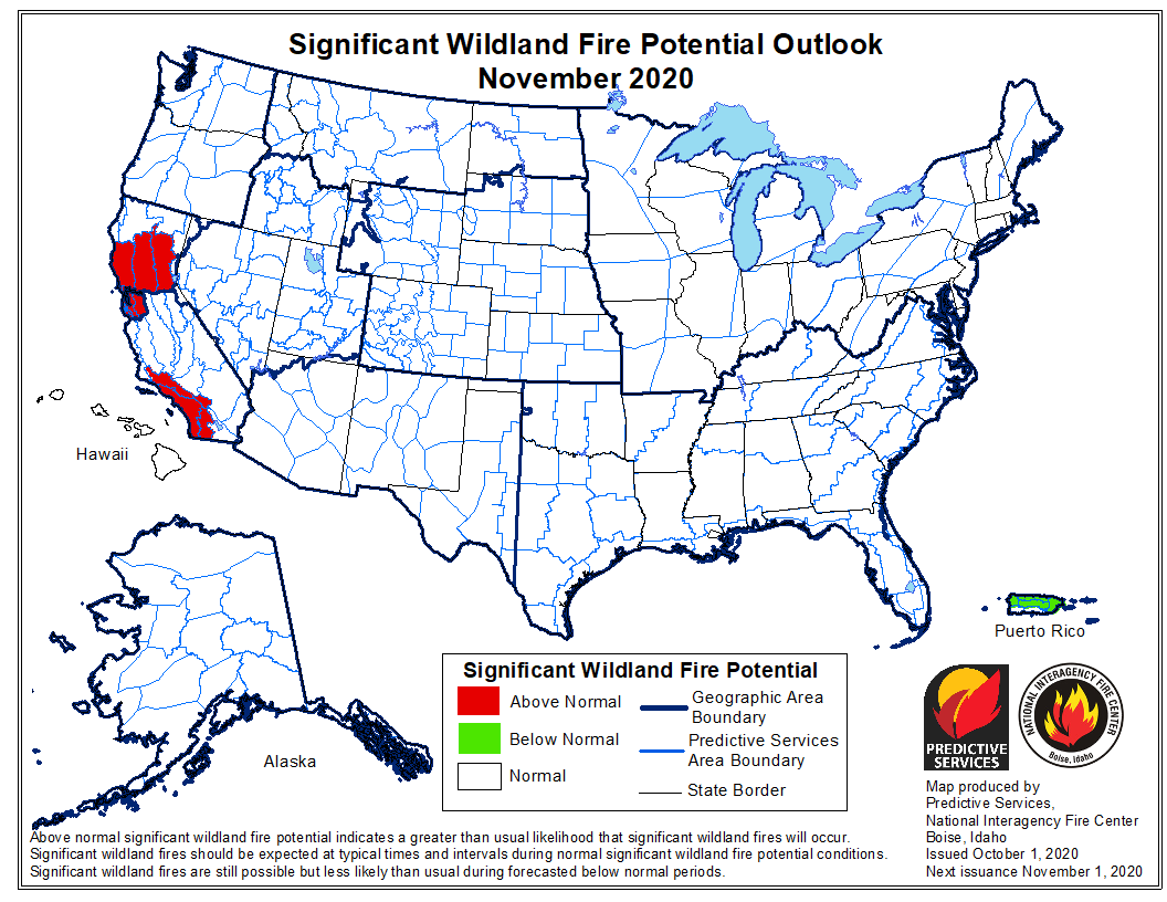
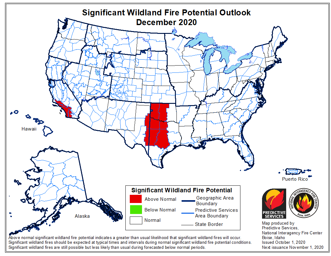
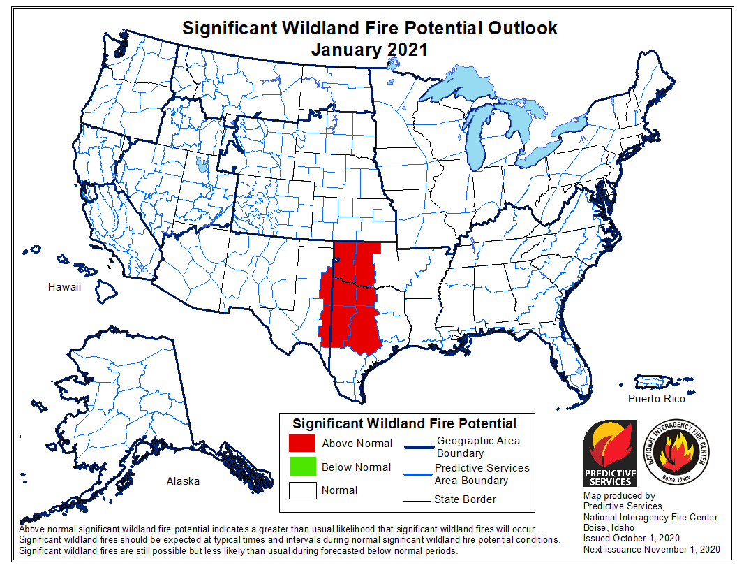
“Above normal significant fire potential is expected across much of California, Arizona, eastern Nevada, Utah, Colorado Rockies, and southern Wyoming in October. However, fire activity and potential will likely diminish across the West, except for portions of California, and remain normal over the Eastern and Southern Areas through November. Elevated periods of fire activity are likely in portions of Oklahoma and Texas and possibly in other locations in the Southern Area during fall into winter.”


wildfire potential for November, 2020 wildfire potential for December, 2020 wildfire potential for January, 2021

90-day temperature and precipitation outlook
90-day temperature and precipitation outlook, October – December, 2020.
Drought Monitor, prepared September 22, 2020
Keetch-Byram Drought Index
Keetch-Byram Drought Index, prepared Sept. 30, 2020

Meteorologists determine the Creek Fire created two fire tornados

Northeast of Fresno, California earlier this month

Satellite photo showing smoke from fires in California
Satellite photo showing smoke from fires in California at 6:01 p.m. PDT Sept 5, 2020. NASA/Wildfire Today. The Creek Fire

The Creek Fire ran for more than 10 miles and burned 36,000 acres during the first 22 hours after it started at 6 p.m. September 4 northeast of Fresno, California. During that time it created two fire tornados and sent its smoke plume up to 55,000 feet, taller than the tornadic thunderstorms in tornado alley.

An analysis by meteorologists from the National Weather service has revealed that the extreme growth on September 5 generated rare phenomenons — vortices rated at EF2 and EF1, sometimes called fire tornados when they are created by a wildfire.

One was near Mammoth Pool Reservoir and the other was near Huntington Lake. Over 200 people trapped by the fire at Mammoth Pool Reservoir were flown out by courageous National Guard Pilots in helicopters, at times through darkness and smoke.

The NWS personnel rated the vortices based on the effects on trees, including areas where trees were debarked, indicating an EF2 event.

Below is an excerpt from an article by Matthew Cappucci  in the Washington Post.

Jerald Meadows, the warning coordination meteorologist at the Hanford office, said both tornadoes shared common features. “The main contributing factor was the debarking of all the pine trees up with the Mammoth Pool tornado,” Meadows said. “They both uprooted trees to the root balls and snapped large pines. But the [EF1 tornado] did not have any signs of true debarking. We’re probably talking the difference between 100 and 110 miles per hour.”

The Mammoth Pool tornado, which touched down inside the Wagner Campground, snapped several two-foot-diameter trees about 20 to 30 feet above the ground; it was rated as having winds of 115 to 125 mph. The Huntington Lake fire tornado had winds of 90 to 107 mph, and the NWS noted that it was “the result of unprecedented fire activity.”

The article reports that the NWS personnel on duty while the tornados were occurring had concerns about activating their severe weather warning system.

“A tornado warning was considered but not issued,” said [Jerald Meadows, the warning coordination meteorologist at the Hanford Office], who feared that disseminating such an alert might leave people unnecessarily conflicted about deciding whether to shelter or evacuate.

“A tornado warning for a fire opens up a can of worms,” he said. “We want to make sure we’re messaging properly, and we were talking to fire crews letting them know of the circulations we were seeing.”

Before the onslaught of fire tornadoes that has been a hallmark of 2020′s blazes, some National Weather Service offices have had internal discussions and concluded that they would not issue tornado warnings for wildfire-related twisters. While the National Weather Service hasn’t issued specific policy guidance to its 122 forecast offices on how to handle fire tornadoes, Meadows suspects considerable research will be needed to reach a resolution.


This article was edited September 26 to clarify the locations of the fire tornados at Mammoth Pool Reservoir and Huntington Lake.

Thanks and a tip of the hat go out to Tom.

Researchers flying over wildfire detected 130 mph updrafts in smoke plume

And, downdrafts reaching 65 mph

Pioneer Fire
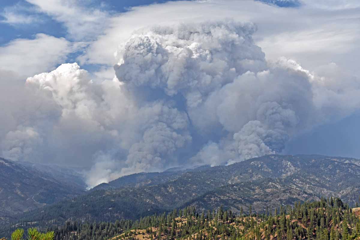
Smoke plume with pyrocumulus over the Pioneer Fire, posted on Inciweb August 29, 2016.

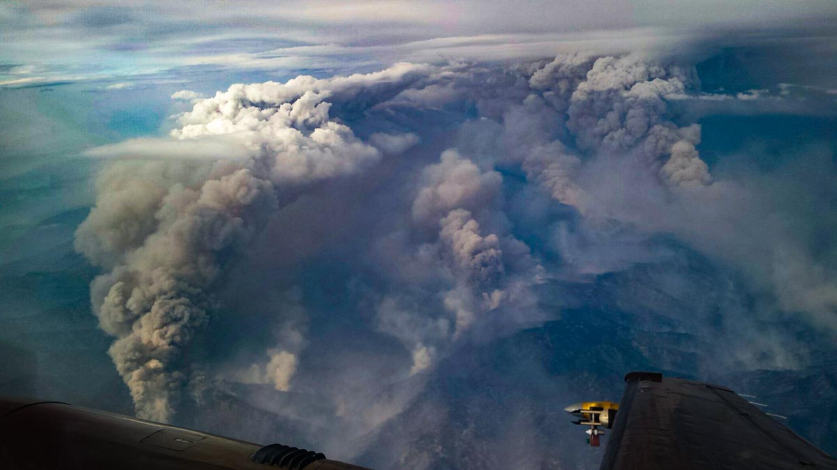
Researchers flying near smoke plumes over a large wildfire found extreme updrafts up to 130 mph and downdrafts reaching 65 mph. Operating radar and other sensing equipment in a small plane, one of the scientists was injured as the aircraft experienced a dramatic vertical displacement as it penetrated a 34-meters-per-second updraft in a plume over a flank of the 2016 Pioneer Fire in Idaho.

This is the first time the vertical velocity structure of a pyroconvective updraft has been viewed in such detail. The research showed that intense fires can produce updrafts that rival or exceed those in tornadic supercell thunderstorms.

An unexpected finding was that the updrafts strengthened with height above the surface, at least initially, challenging the assumption that they should decelerate with height.

The updrafts, the strongest ever documented, can be a hazard to aviation since they do not always show up on pilots’ weather avoidance radars, as discovered during a Qantas flight over a bush fire in Australia in January, 2020. Passengers experienced turbulence and darkness as the airliner entered the pyrocumulus cloud.

"There was one guy sort of swearing … I heard people down the front vomiting."

Another passenger said it was "the scariest flight" she had taken.
smoke plume research convection column pyrocumulus
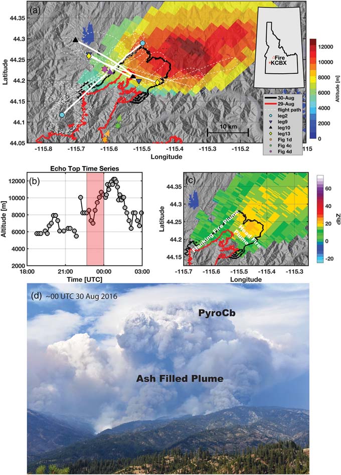
Overview of the PyroCb topped plume rising from the Pioneer Fire on 29 August 2016. (a) Map showing the fire perimeters, flight legs, locations of photos (triangle markers), terrain (hillshaded), and KCBX radar‐derived plume “echo top” heights (color shaded). (b) KCBX echo top time series showing rapid plume growth and the flight interval (red shaded). (c) Time mean KCBX radar reflectivity during the flight interval with head and flanking fire plumes annotated. (d) Photograph from the Boise National Forest at ~00 UTC 30 August 2016 showing the head fire plume and the transition from the ash‐filled lower plume to the pyroCb aloft. (from the research)

These findings are presented in a paper published September 9, 2020 written by B. Rodriguez, N. P. Lareau, D. E. Kingsmill, and C. B. Clements.

Convection column Pioneer Fire
Convection column with pyrocumulus over the Pioneer Fire, August 30, 2016. Photo by Nick Guy of the University of Wyoming.