Wildfire potential to remain high this month in Montana, Carolinas, and Hawaii

In February and March high fire potential expected for Southern Plains, Southeast Colorado, and Eastern New Mexico

December fire weather outlook

The forecast for wildland fire potential issued December 1 by the National Interagency Fire Center predicts that the December potential for wildfires will be higher than average in Central Montana, Hawaii, and the coastal areas of Georgia and the Carolinas. By February and March the fire danger will be higher than average across eastern New Mexico, west Texas, western Oklahoma, southeast Colorado, and western Kansas.

The data from NIFC shown here represents the cumulative forecasts of the ten Geographic Area Predictive Services Units and the National Predictive Services Unit.

High temperatures in the West

Temperatures far above average have been breaking records the last few days across much of the West, but especially in Oregon, Washington, Idaho, Montana, and the Dakotas. The heat combined with strong winds has resulted in a number of wildfires in Montana on Tuesday and Wednesday of this week.

Below:

  • An excerpt from the NIFC narrative report for the next several months;
  • Additional NIFC monthly graphical outlooks;
  • NOAA’s three-month temperature and precipitation forecasts;
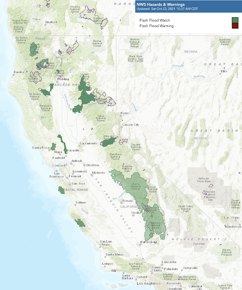
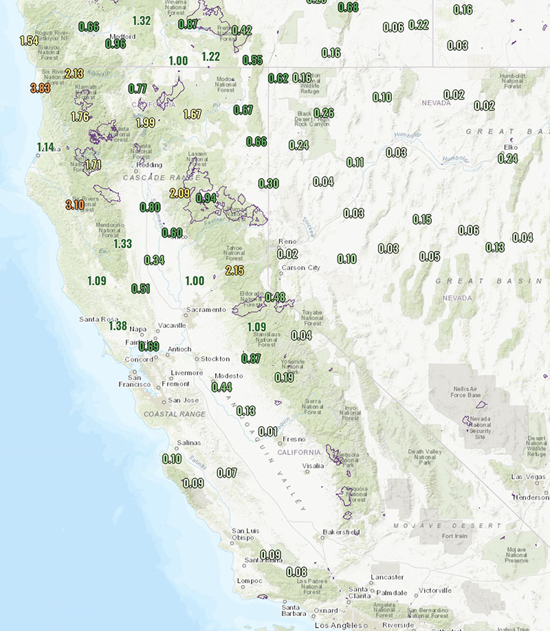
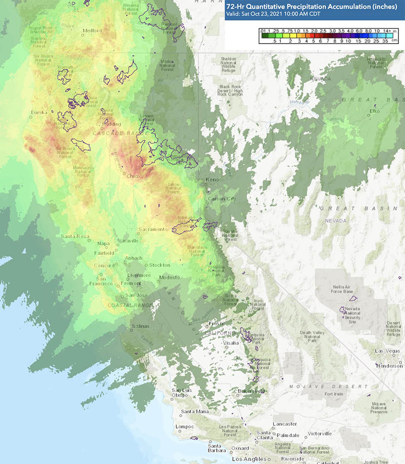
  • Drought Monitor;
  • Keetch-Byram Drought Index.

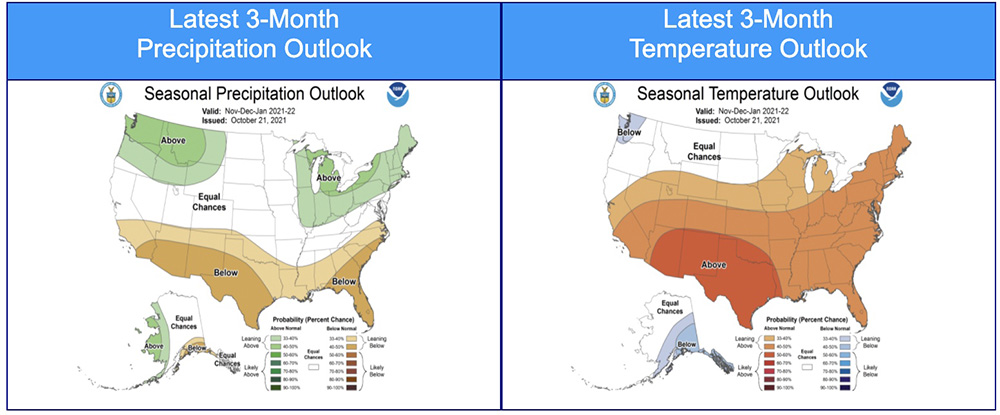
“Climate outlooks for winter indicate above normal temperatures are likely along the southern tier of the CONUS, with the highest probabilities likely in the Southeast. Below normal temperatures and above normal precipitation remain expected across the Pacific Northwest and through portions of the northern Rockies and northern High Plains. The Great Lakes is also likely to experience above normal precipitation through February. Below normal precipitation will likely accompany above normal temperatures across the southern half to one-third of the western US, through much of Texas, along the Gulf Coast, and into the Carolinas.

“Above normal significant fire potential will continue on the plains of central and eastern Montana in December as this area remains snow-free with periodic dry and windy conditions. Additionally, leeward sides of the Hawai’ian Islands and the Coastal Plain in the Carolinas and Georgia are forecast to have above normal significant fire potential in December. Through winter, above normal significant fire potential is expected to expand into much of Florida and Georgia, while returning to normal potential in the Carolinas.

“Critical fire weather could bring periods of elevated fire potential to the southern Plains in December and January. However, there is greater confidence in above normal significant fire potential emerging by February across eastern New Mexico, west Texas, western Oklahoma, southeast Colorado, and western Kansas. Above normal potential is likely to expand eastward across Texas and Oklahoma and to lower elevations in southeast Arizona and southern New Mexico during March. This above normal potential will be acute during wind-driven events.”


January fire weather outlook February fire weather outlook March fire weather outlook

Continue reading “Wildfire potential to remain high this month in Montana, Carolinas, and Hawaii”

Wind gusts over 60 mph lead to preemptive power shutoffs in Southern California on Thanksgiving

Red Flag warnings in effect

10:30 a.m. PST Nov. 25, 2021

Wind gusts 50+ mph, 938 a.m. PST Nov. 25, 2021. California.
Wind gusts 50+ mph, 9:38 a.m. PST Nov. 25, 2021. California.

Red Flag Warnings and wind gusts of 50 to 69 mph have led to preemptive power shutoffs in Southern California on Thanksgiving day.

Southern California Edison reported at 10:25 a.m. Thursday that 1.1 percent, or 63,835 of their customers, have had their electrical power turned off as a preemptive measure to prevent wildfires if the strong winds blow down power lines. An additional 156,000 customers are in areas where power shutoffs are under consideration.

At 9:38 a.m. Thursday 44 weather stations had wind gusts that exceeded 50 mph, with the highest being 69 mph at Cloudland Cutoff. At that time 380 stations recorded conditions meeting Red Flag Warning criteria, and another 307 were flirting with the status. Most had relative humidity in the low teens.

The strong winds out of the northeast are expected to decrease Thursday afternoon and by 8 p.m. will be less than 7 mph in most areas. But the extremely low relative humidity in the single digits or teens will continue through Monday.

As this is being written at 10:30 a.m. PST Thursday there have been no reports of large fires during this wind event.

Red Flag Warnings, Southern California
Red Flag Warnings, Southern California, Nov. 25, 2021

Flash flood watches in effect near recent wildfires in California

9:40 a.m. PDT Oct. 23, 2021

Flash flood watches and 2021 fires
Flash flood watches (green shaded areas), 8:37 a.m. PDT Oct. 23, 2021. The purple lines indicate the perimeters of fires in 2021.

The National Weather Service has issued numerous flash flood watches for areas near many of the recent California wildfires. Heavy rain could bring ash and debris flows to locations below recently burned areas. At 8:37 a.m. on Saturday the NWS had not listed any major flash flood warnings in Oregon or Washington.

The atmospheric river combined with a bomb cyclone are bringing massive amounts of precipitation to areas of Northern California, Oregon, and Washington.

Precipitation accumulated California
Precipitation accumulated during the 48-hour period ending at 8:56 a.m. PDT Oct. 23, 2021. The purple lines indicate the perimeters of fires in 2021.

Precipitation accumulated over the 48-hour period ending at 8:56 a.m. PDT Oct. 23 showed approximately 1 to 2 inches near the Dixie Fire, one-half to 1 inch near the Caldor Fire, and 1 to 3 inches in northwestern California near the McCash, Monument, and River Fires. About 1 to 2 inches were recorded near the fires of 2020 in the Napa and Santa Rosa area, and up to 3 inches at the Doe and Hopkins Fires of 2020.

And more is on the way.

Predicted 72-hour cumulative precipitation and 2021 fires
Predicted 72-hour cumulative precipitation. The purple lines indicate the perimeters of fires in 2021.

The video below is an October 22 briefing from the National Weather Service about the storm system that is bringing heavy rain and mountain snow, along with the potential for urban flooding and ash and debris flows to recently burned areas.

Multiple atmospheric rivers to bring massive precipitation to West Coast

Portions of Northern California may receive more than 10 inches of precipitation during the next 7 days

9:58 a.m. PDT October 21, 2021

Cumulative precipitation, Oct. 21-28, 2021
Cumulative precipitation, Oct. 21-28, 2021. Issued 5 p.m. PDT Oct. 20, 2021.

Forecasts are still being fine-tuned, but it appears likely that areas of Northern California, Oregon, and Washington will receive huge amounts of precipitation over the next seven days, with portions of Northern California getting more than 10 inches.

At least four waves of atmospheric rivers are barreling across the Pacific targeting the West Coast. The animated GIF below illustrates the progression of these “rivers.”

atmospheric rivers

Predictions are subject to change, but the first band, beginning Thursday morning, will have the heaviest impacts in WA, OR, and northwest CA.

Sunday morning will bring another, centered in Central California.

The third wave will start to come through Tuesday, with the heaviest precipitation expected in Northern CA and OR.

The forecast could change over the next seven days, but the prediction is that another wave will primarily impact OR and WA on Thursday, Oct. 28.

With it already being the second half of October, it is likely that these atmospheric rivers will bring an end to the wildland fire season in Washington, Oregon, and Northern California. Most of Southern California south of Santa Barbara is expected to receive less than a half inch of precipitation, so if the rest of of the year there is warm, dry, and windy the area could still see more wildfire activity.

The three-month temperature and precipitation outlook issued today predicts November through January conditions in SoCal that will be warmer and drier than average. But if significant precipitation occurs in the next seven days, it would require some serious Santa Ana wind events to dry the soils and vegetation enough to enable large fires to occur.

Three-month temperature and precipitation outlook
Three-month temperature and precipitation outlook issued October 21, 2021.

Critical fire weather and Red Flag Warnings predicted for much of California Monday and Tuesday

Strong winds and low humidity to begin Sunday night

6:35 p.m. PDT Oct. 10, 2021

Forecast for wind gusts, Sunday night through Tuesday, California
Forecast for wind gusts, Sunday night through Tuesday, Northern California. NWS Sacramento, at 1 p.m. PDT Oct. 10, 2021.

Much of California between Los Angeles and Redding will be under elevated fire danger or Red Flag Warnings Monday and Tuesday. Strong north winds are predicted to begin Sunday night, peak on Monday, and last through Tuesday. Temperatures will not be as high as is seen in typical Santa Ana wind events, but they will be higher than normal and relative humidities will be low.

In the North Bay, for example, winds will develop late Sunday evening from the north at 30 to 40 mph, and will be locally higher near favored gaps, canyons, and in the Valley. Minimum humidity will drop to 10 to 25 percent Monday and slightly lower on Tuesday. Overnight recovery will be 25 to 50 percent.

Any fires that develop could spread rapidly.

Storm Prediction Center outlook for critical fire weather
Storm Prediction Center outlook for critical fire weather, Monday, Oct. 11, 2021. Updated at 11:46 a.m. PDT Oct. 10, 2021.

We will update this article on Monday Oct. 11 as this event develops.

Red Flag Warnings in effect for the Great Plains Saturday

Strong winds and low humidity expected Monday and Tuesday in portions of California

Red Flag Warnings and Fire Weather Watches
Red Flag Warnings and Fire Weather Watches at 10 a.m. PDT October 9, 2021. NWS/Google.

Red Flag Warnings are in effect Saturday for areas in Colorado, Kansas, New Mexico, Texas, and Oklahoma for warm, dry, windy weather. The relative humidity could be as low as 14 percent, wind gusts to 45 mph, and temperatures in the 80s; however, these numbers could vary over this large area.

Critical fire weather for California
Critical fire weather for California, Monday Oct. 11, 2021.

Fire Weather Watches have been posted in California for critical fire weather. North wind gusts of 35 to 50 mph, locally higher, will develop late Sunday night and continue into Tuesday across the Central Valley and Coast Range. Strongest winds are expected along the west side of the Valley and in the Delta on Monday. North to northeast wind gusts of 30 to 40 mph, locally higher near favored gaps and canyons, will develop Monday and continue Tuesday over the foothills and mountains. The humidity will be in the 15 to 25 percent range Monday, and slightly lower Tuesday.

These weather conditions could cause wildfires to spread rapidly.

The map below shows the precipitation in California and Nevada during the 72-hour period that ended at 9 a.m. PDT October 9, 2021.

Precipitation ini the 72-hour period
Precipitation in the 72-hour period ending at 9 a.m. PDT Oct. 9, 2021. NOAA.