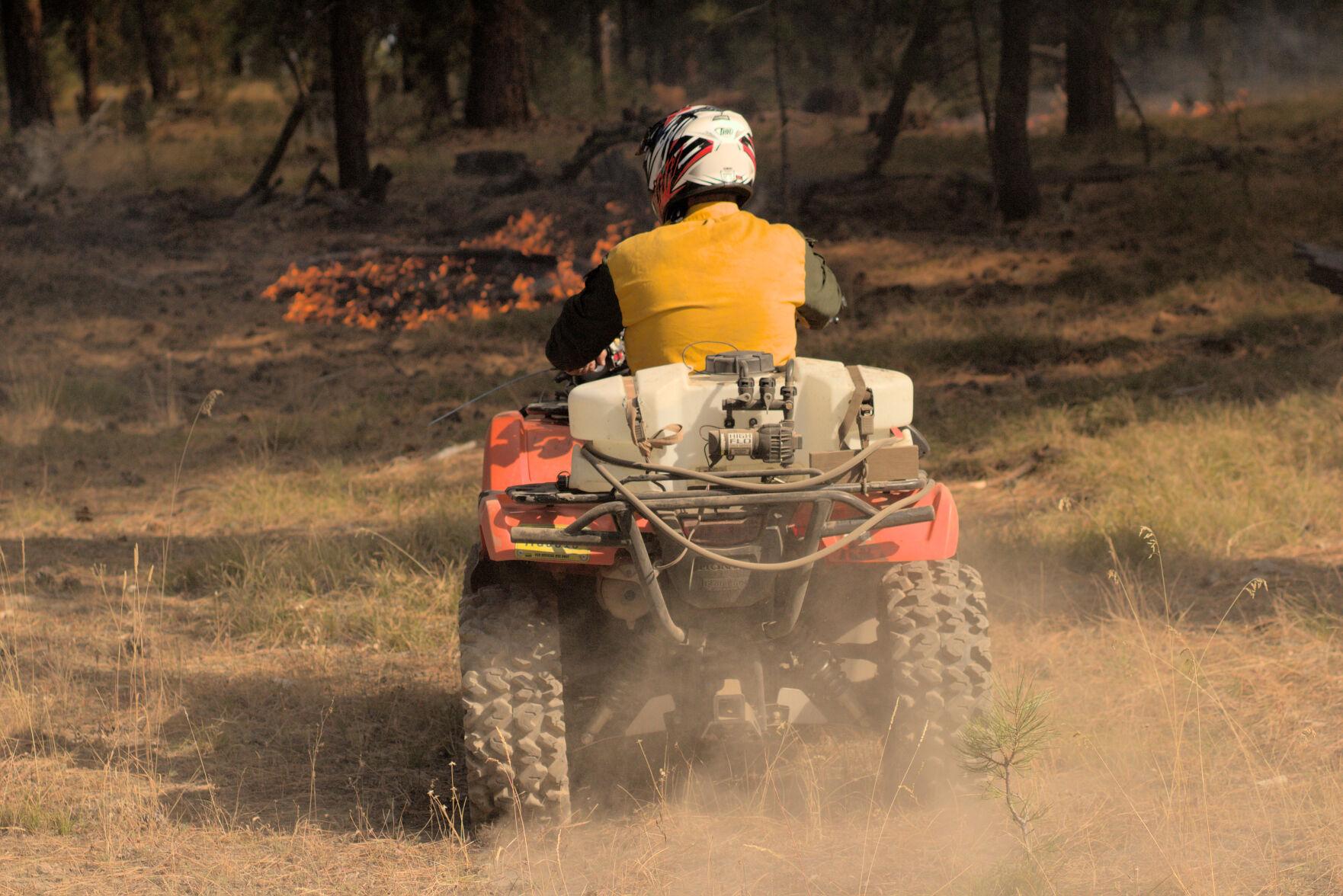
Firefighter at the Starr 6 prescribed fire, Oct. 19, 2022. Tony Chiotti – Blue Mountain Eagle.
On November 2, 2022 the National Federation of Federal Employees (NFFE) issued the following statement about the federal employee who was arrested by the Grant County Oregon sheriff last month. At the time the firefighter was running the operation as the Burn Boss on the Starr 6 prescribed fire when it grew unexpectedly and spread onto about 20 acres of private land.
Today, the National Federation of Federal Employees (NFFE) strongly condemns the wrongful arrest of Rick Snodgrass, a U.S. Forest Service (USFS) wildland firefighter who was working as an active “burn boss” when taken into sheriff’s custody on October 19, 2022. At the time of his arrest, Firefighter Snodgrass, an Assistant Fire Management Officer, was working as the incident commander overseeing fire operations and containment efforts during a prescribed burn on the Malheur National Forest in Grant County, Oregon. Grant County Sheriff Todd McKinley arrested Firefighter Snodgrass during the burn operation after the fire unexpectedly jumped a roadway when wind picked up, causing the fire to burn several acres of grasslands on private property.
NFFE National President Randy Erwin released the following statement after the arrest of USFS Firefighter Snodgrass:
“It is unconscionable that a local sheriff would arrest a working wildland firefighter during an active fire operation. Not only did the sheriff exceed his authority in detaining Firefighter Snodgrass, in doing so, the sheriff put everyone and everything in danger by removing a working fire commander during a dangerous incident. Firefighter Snodgrass was arrested for simply doing his job.
“We applaud all of the wildland firefighters on the line that day who held their focus despite the Sheriff’s interference. Undeterred, they worked together to contain the blaze and finish the job. Our firefighters who conduct and lead prescribed burns, like Firefighter Snodgrass, are highly trained professionals. They know how to manage the most dangerous situations. Prescribed burns are essential to keeping communities across this country safe from wildfires. When dealing with unpredictable environmental conditions, it is always possible that a prescribed burn could spill over into an untargeted area. Normally when this happens, the government will address any damages to affected parties as appropriate. It is not normal for a local sheriff to arrest a working fire commander during an incident. In doing so, the sheriff may have violated federal law that makes it a felony to interfere with a federal employee during their official duties, and the sheriff may have opened the county to massive liability for a civil rights violation for unlawfully detaining and removing Firefighter Snodgrass.
“Firefighter Snodgrass has the full, unconditional support of your union, as does every federal wildland firefighter across this country. NFFE is calling on state and federal authorities to investigate the reckless actions of Sheriff McKinley to pursue any violation of civil and criminal law. This incident will not be swept under the rug. There must be consequences for this unprecedented abuse of power and incredibly dangerous disruption to the critical work of the Forest Service.
“We applaud the USDA and the USFS for expressing their full support of Firefighter Snodgrass in the performance of his official duties. NFFE will continue to follow this investigation and provide support to Firefighter Snodgrass to ensure that rogue sheriffs or any other person who threatens or impedes public servants answer for their actions.”
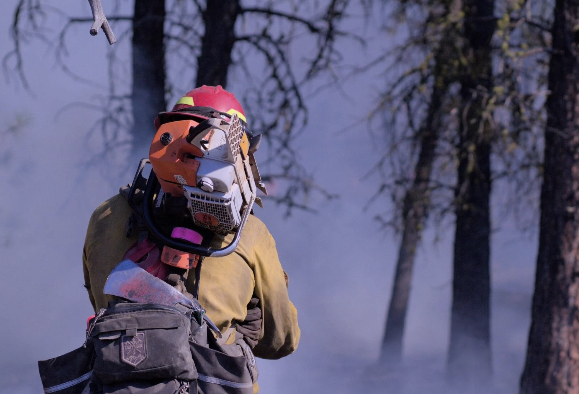
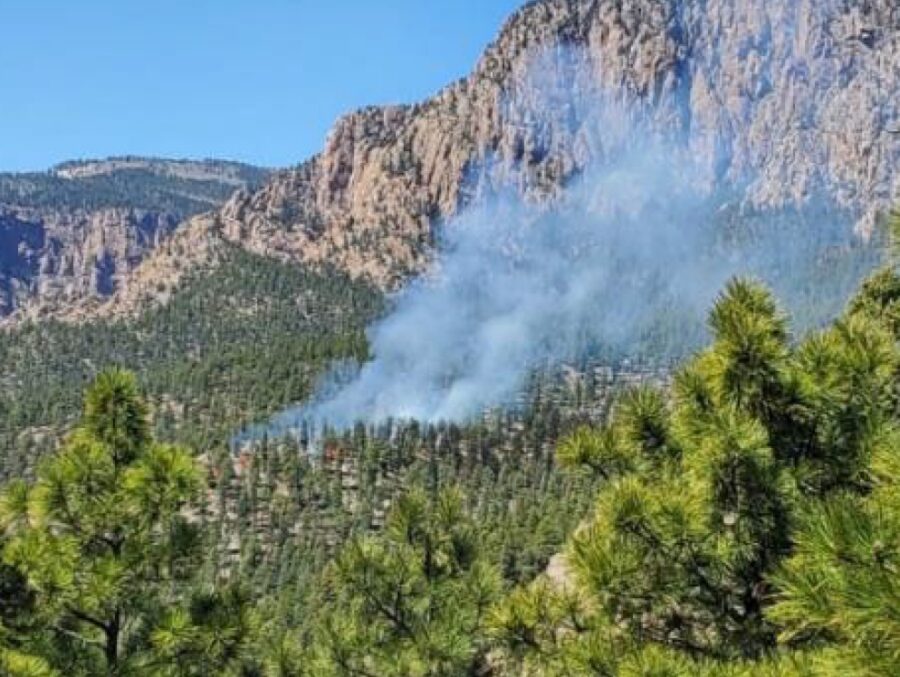
A Grayback employee at the Starr 6 prescribed fire, Oct. 19, 2022. Tony Chiotti – Blue Mountain Eagle.
Editor's note
This article was written by Blue Mountain Eagle reporter Tony Chiotti who was on the scene of the Starr 6 prescribed on the Malheur National Forest in Oregon before it jumped containment and spread to private land on Oct. 19. In reporting this story, he drew on observations made that day as well as multiple interviews with Forest Service officials, burn crew workers, and landowners. It is used here with permission.
When Rick Snodgrass approached Grant County Sheriff Todd McKinley, he thought the sheriff was there to help him.
According to Snodgrass, he’d called for law enforcement to help control aggressive traffic and to deal with harassment his crews had been receiving while implementing a prescribed burn on the Malheur National Forest in Bear Valley, about 7 miles north of Seneca.
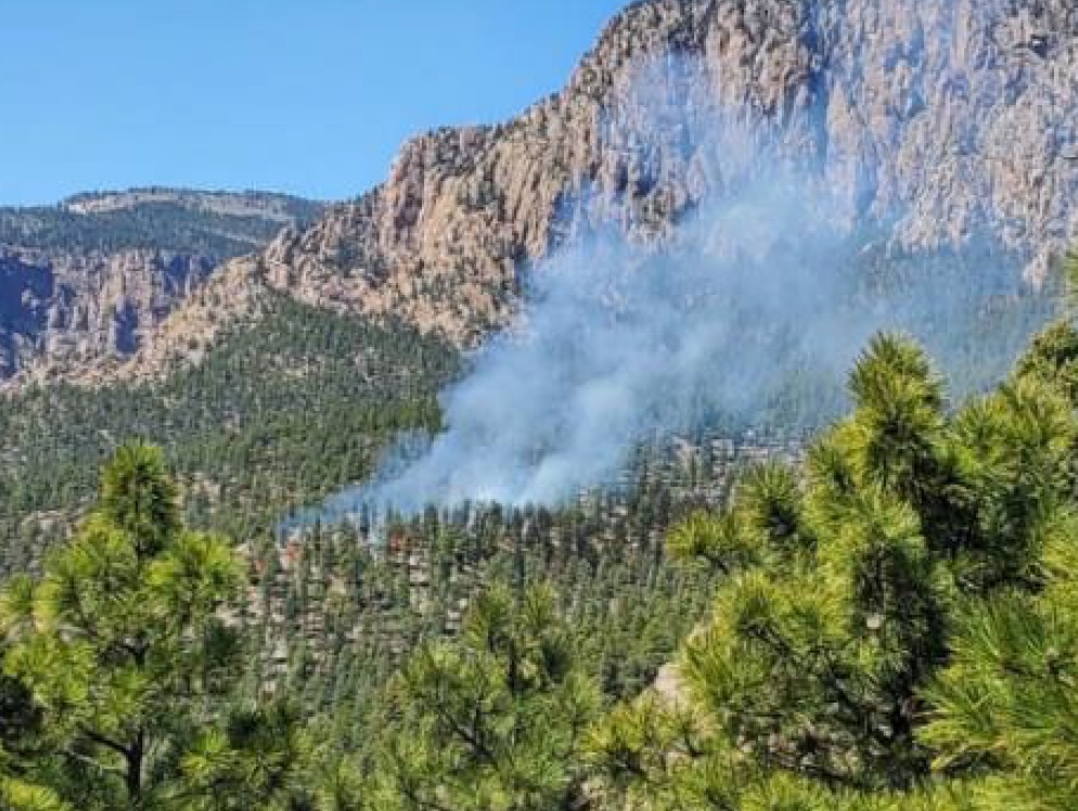
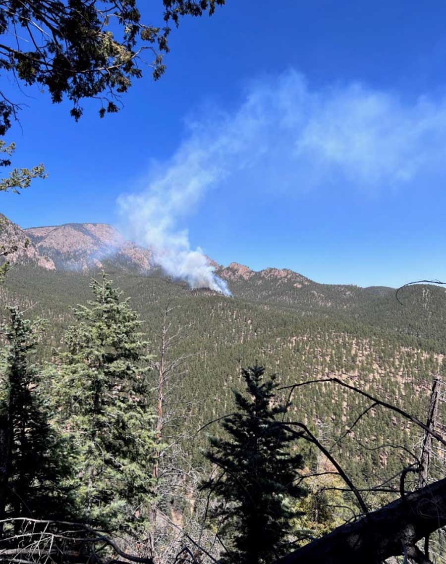
That burn — called the Starr 6 — had since jumped the fireline, and now there was active fire on both sides of County Road 63, where Snodgrass and McKinley met: the prescribed burn operation on Malheur National Forest land to the north of the road — now flaring up in gusts of wind — and an uncontained slopover on private land to the south. The crews under Snodgrass’ direction were now attempting to quell one fire while holding the reins on another, with tempers, smoke, wind and now traffic adding to the dangers to his crew.
But instead of assistance, what Snodgrass got was arrested.
When the sheriff cuffed Snodgrass, it is thought to be the first time a U.S. Forest Service firefighter has been arrested in the course of performing their job.
Snodgrass, the “burn boss” on the day’s operation, was taken away from the scene and charged with reckless burning, a Class A misdemeanor that carries a maximum penalty of a year in jail and a $6,250 fine. Before it was contained, an hour after it kicked off, the spot fire burned an estimated 20 to 40 acres of private land owned by members of the Holliday family.
The arrest of Snodgrass on Wednesday, Oct. 19, has drawn national attention and has fanned the debate over Forest Service fire mitigation policies, especially as they pertain to intentional burns adjacent to private lands.
And in the aftermath of this burn, there are accusations on both sides of this contentious debate about which actions on that day deserve the blame. Critics of the Forest Service and the affected landowners feel the conditions on the day never should have allowed the burn to proceed. Others, including Forest Service personnel who planned and executed the burn, say that by arresting the burn boss at the moment of maximum danger, the planned operation and the safety of the crews were placed in jeopardy.
“Other individuals were able to pick up the slack, fortunately, that were well trained,” Snodgrass said. “He put not only my guys at risk out there, their safety, but he put that land at risk as well as, you know, all of Bear Valley.”
The buildup
In 2015 the Canyon Creek Fire, which started with lightning strikes on Malheur National Forest land and spread to private ground, ultimately burned over 110,000 acres and destroyed 43 structures in Grant County.
There is general agreement that a hundred years of fire suppression has led to forests that are overfilled with fuel, a situation made more dangerous by a prolonged drought. Part of Canyon Creek’s legacy is the strongly held and polarized views on how to best prevent catastrophic fires in the future.
Proponents of prescribed burning see the scorched canyons along US 395 as a reminder of the stakes, the need to create buffers, remove built-up fuels and restore forests to a pre-suppression state where they can better survive the inevitable blaze, while critics of federal land management and the Forest Service see a constant reminder of botched containment efforts and mismanaged public land that only fuel their distrust.
“Every individual has a different opinion and motivation,” said Craig Trulock, supervisor of the 1.7 million-acre Malheur National Forest. “You have people that are just anti-federal and don’t want any federal agency doing anything that could affect their lands. Others don’t like prescribed burning for various reasons, whether it’s risk or a sense that it doesn’t achieve what we should be doing out there because they want every log to go on a log truck. And then you have people that are saying, ‘When you burn, would you please burn my property as well?’”
According to Trulock, the burn had been going to plan. “We were within prescription on the burn,” Trulock said, noting he couldn’t say much more as the incident is now the subject of an active federal and local investigation.
Firefighter at the Starr 6 prescribed fire, Oct. 19, 2022. Tony Chiotti – Blue Mountain Eagle.
The fire was the second day of prescribed burning in as many weeks. The burn area planned for Wednesday, Oct. 19, was 300 acres, including trees and meadowland within the Malheur National Forest in an operation involving federal, state and contract firefighting crews, according to information from the Forest Service.
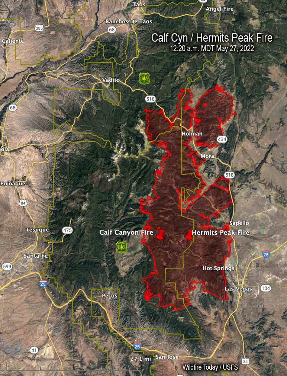
This was among the first prescribed burns to be allowed after a new set of restrictions came into effect this year, following high-profile cases of prescribed burns getting out of control on federal land and causing massive damage, including the Calf Canyon/Hermit’s Peak blaze in New Mexico, which burned several hundred thousand acres and hundreds of structures this spring. After a 90-day pause on all prescribed burns, a revised set of restrictions was published.
As part of those new rules, before ignitions could begin in Bear Valley, a go/no-go checklist had to be completed on site.
This day’s final check represented the end of a multiyear process. That process involved an environmental analysis of the project area that included commercial logging, noncommercial thinning and burning treatments. The burn plan takes the form of a 100-plus-page document, updated year over year as the preparatory steps of thinning, fuel removal and tree grinding continued, all to get the area into ideal shape for a burn.
As part of the new rules, the final ignition authorization had to be signed by four people: the agency administrator, local unit line officer, burn boss, and fire management officer or duty officer. This process only authorizes ignitions for 24 hours, in effect giving all four officers veto power over the burn based on that day’s conditions.
On this day, all four individuals assessed the conditions, and all four signatures were affixed to the burn authorization, meaning ignitions could begin. One of those four signatures belonged to Rick Snodgrass.
Smoldering tensions
The ignition was delayed for about 45 minutes while crews did a grid search to ensure there were no cows in the burn area after hearing reports that the Hollidays still had some “stragglers” left on national forest land, a common occurrence as cows are seasonally moved off grazing allotments. The Windy Point Ranch allotment specified an Oct. 15 “off date,” but Chad Holliday explained that some fence that was burned the previous week, along with gates being left open by fire personnel, meant he couldn’t be sure the cattle were all out.
Initially, the burn went according to plan, with light winds of 0-3 mph and the heat of the fire drawing smoke up into a clean, bent column over the county road. The fire moved slowly across 50 acres over the course of five hours, with fire crews monitoring the progress of its leading front and continuing drip-torch ignitions.
Ignitions paused in the afternoon, to begin again a couple hours later. It was then that the wind picked up and a few trees in the interior of the already-burned area torched, sending up “duffers” with the smoke, up and over the road.
Members of the Holliday family, who own the Windy Point Ranch and other land adjacent to the burn area, were standing across the county road from the fire as an ember from the burn area touched town on their ranch, starting a new fire that soon began to spread.
“We were glad to see Oregon Department of Forestry and Grayback (contract crews) show up,” said Mandy Taylor, Chad Holliday’s sister.
ODF and Grayback Forestry crews were contracted to work alongside Forest Service employees throughout the day’s burn, but due to tensions between the landowners and the federal crews, they were eventually asked to take over mop-up after the flames of the spot fire were extinguished, according to Trulock, who said the move was meant to calm tensions on the scene.
Those kinds of tensions are not unusual.
“I think in a lot of parts of Oregon, it’s just a very real experience for federal employees to have a lot of hostility towards what they’re doing right now,” said Christopher Adlam, a regional fire specialist for Oregon State University’s Extension Service. “I’m not saying that people don’t also appreciate firefighters and thank firefighters. But it’s a pretty common thing in some parts of Oregon for federal employees to face hostility.”
Indeed, federal crews called the regional interagency dispatch center on both days of the burn to report verbal harassment, threats and aggressive driving through the smoke, and to request law enforcement assistance on the scene.
The Hollidays maintain they were welcoming and cooperative with federal crews, providing access to their land in order to contain the blaze. But as the fire spread and crews worked to contain it, the Hollidays called 911. They didn’t call to report the fire. They asked for the sheriff. “We knew that somebody was doing something wrong,” said Taylor.
Planning for contingencies
If you use the phrase “controlled burn” in the vicinity of firefighters operating a prescribed burn, you will be corrected.
This is fire. You don’t control it. The best you can plan for is to manage it and be prepared if the fire has other ideas.
Adlam points out that spillover fires like the one that happened in Bear Valley are rare occurrences but can still have a huge impact on people. “I think that, the last 20 years, we’ve had one other occurrence of a burn crossing over from federal land onto private land in Oregon,” he said.
The Malheur National Forest supervisor notes that the spillover was quickly brought under control.
“They caught it with the resources they had on scene,” said Trulock. He noted that the number of crew on scene before the fire jumped was far more than their own burn plan had recommended, and that the new rules and added caution likely led to their ability to ultimately contain the spot. “We didn’t use any aviation or anything. The only additional resource we brought on was that dozer, and that was to really secure the edge of the spot so that they could then mop it up. So we were staffed enough to actually catch something like this.”
The Grant County Sheriff’s Office and the Forest Service estimated the size of the spot fire as approximately 20 acres. Chad Holliday estimates it as closer to 40, after measuring the perimeter of the area at “exactly one mile.”
“Somebody’s got to be held accountable”
As the federal crews were attempting to control the spot fire on the ranch, McKinley arrived. Chad Holliday received a call from his sister, who was on the scene and told him to get home. He arrived to see Sheriff McKinley speaking with people along the fence.
“I walked up, and Todd said, ‘Chad, right now you’re (being) videorecorded. You’re the spokesman for the ranch. Would you like to press charges?’ And I said, ‘Absolutely. Somebody’s got to be held accountable.’”
Holliday said McKinley then went directly to Snodgrass on the county road and “put the cuffs on him.”
The Eagle has filed a public records request for bodycam footage or any other video taken at the scene during this incident by the Grant County Sheriff’s Office. The newspaper is also seeking any other video footage captured at the scene that could further help establish the sequence of events.
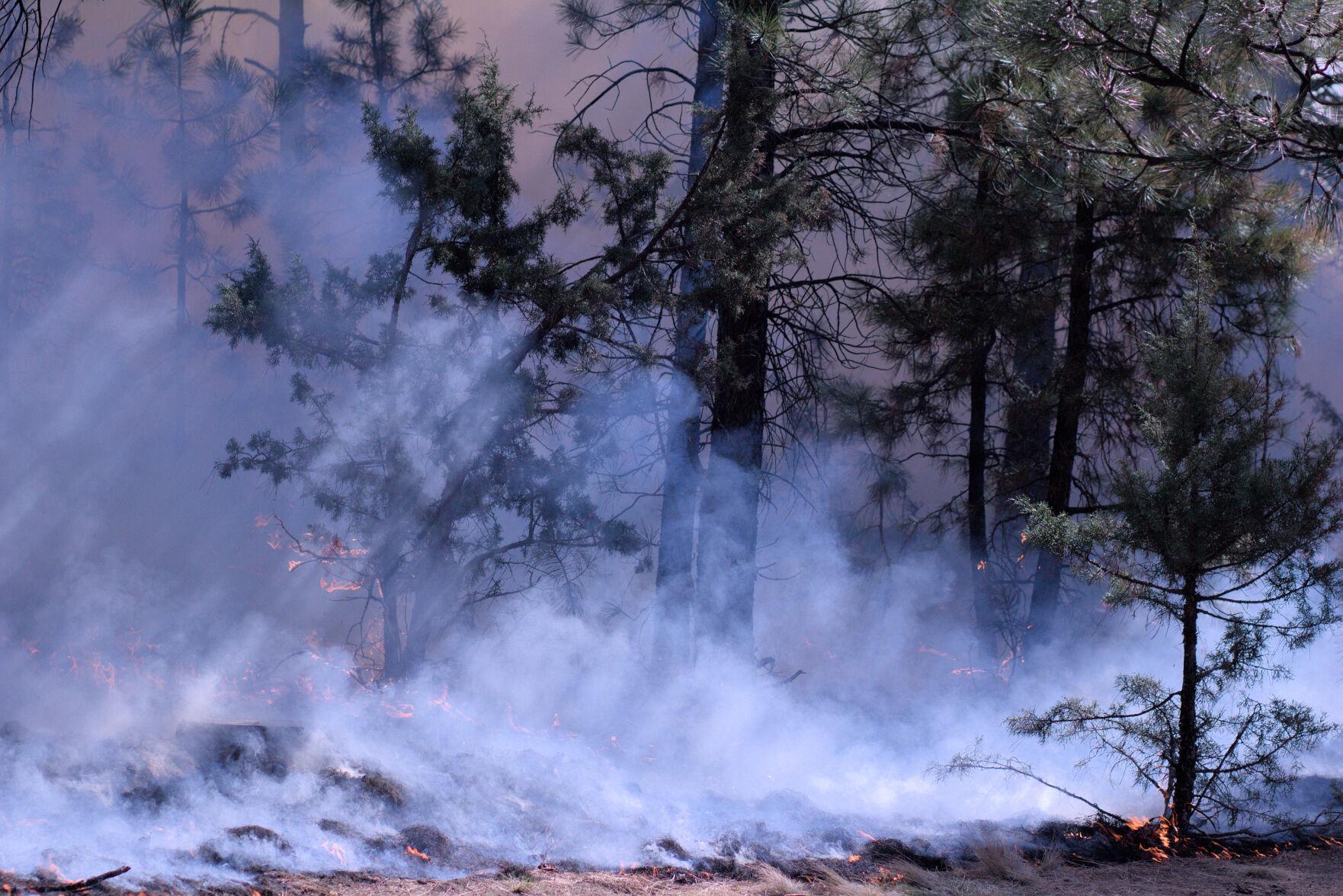
The Starr 6 prescribed fire, Oct. 19, 2022. Tony Chiotti – Blue Mountain Eagle.
“A reasonable person”
The fire was set in the days before predicted rain, and will likely prove to be the last of this year’s short burn season. But the issues surrounding prescribed burning and federal land management, especially as it impacts private landowners, will undoubtedly remain a flashpoint in Grant County.
For now, as the investigation continues, McKinley is playing things close to the vest. He’s declined offers to comment on the case beyond his initial press release, which said “details cannot be released at this time.”
Grant County District Attorney Jim Carpenter has been slightly more forthcoming, stating in his own press release that just because the burn boss was working as part of a federal crew doesn’t mean he will be shielded from potential legal consequences.
“To be clear, the employer and/or position of Snodgrass will not protect him if it is determined that he acted recklessly,” he wrote. “That the USFS was engaging in a prescribed burn may actually raise, rather than lower, the standard to which Snodgrass will be held.”
Carpenter lays out in his release the full legal standard for determining if a burn is or is not “reckless” as defined in Oregon statute: “The risk must be of such nature and degree that disregard thereof constitutes a gross deviation from the standard of care that a reasonable person would observe in the situation.”
McKinley, known as a level head in the wider context of Grant County politics, might not have intended to make a statement. But this extraordinary arrest has caught national attention and sparked debate in the press and online. And now in the actions of the sheriff and the actions of the Forest Service, both sides see actions that created real danger.
Critics of the Forest Service point to the simple fact that the fire escaped the lines as evidence the conditions were unsafe and that the fire should never have been approved. To the Hollidays, and those skeptical of federal land management in general, it’s a clear measure: the fire got onto their land and threatened or destroyed their property. How could that have been a reasonable thing to do?
It has also stirred the ire of wildland firefighter communities, who fear this development will set a precedent and only complicate an already difficult and dangerous job. And in these groups’ online conversations, it is clear many believe that the arrest created a situation on the ground that may have added to the real risk faced by fire crews in Bear Valley.
“One of the huge watch-out situations in any fire operation is a transition in leadership,” said Trulock. “And that’s when it’s a plan to transition in leadership. This was obviously unplanned. What I would say is there were definite heightened risks because of that action. Until leadership can be reestablished under a new person, then everybody is distracted because they know something happened. And so it created a huge distraction in the middle of what I would consider is a relatively high-risk operation.”
Adlam, the Extension Service fire specialist, agreed.
“The burn boss’s role is never more important than at the moment where something happens that is not part of the plan,” he said. “If you cut off the head of an operation before it’s finished, how is that supposed to be leading to a positive outcome?”
When reached for comment on this story, McKinley clarified why he’s reluctant to say too much at this point.
He said he knows how it appears in the court of public opinion to withhold detail, but added that as long as it protects the process he just doesn’t care. “I just want to respect the case and not get too much detail out so that it doesn’t mess with potential jury pools and all that,” he said, “because then we’d have to have (the trial) out of the area.”
For McKinley, the important thing is that the facts surrounding this case and the decisions of Rick Snodgrass are ultimately determined by 12 reasonable people — ideally, reasonable people from Grant County.
Late Friday afternoon Chief of the Forest Service Randy Moore sent an email to all Forest Service employees regarding the Wednesday October 19 arrest of a Burn Boss while conducting a prescribed fire that slopped over the Forest boundary, burning approximately 18 acres of private land.
“This week, there was an incident in the Pacific Northwest Region where a Forest Service Burn Boss was arrested while leading a prescribed fire that crossed over onto private lands,” the email read in part. “They were engaging in appropriate, coordinated, and vital prescribed fire work alongside state and other colleagues approved and supported by the Agency Administrator. In my opinion, this arrest was highly inappropriate under these circumstances, and I will not stand idly by without fully defending the Burn Boss and all employees carrying out their official duties as federal employees.
“This employee should not have been singled out, and we are working to address these unfortunate circumstances on their behalf,” Chief Moore continued. “This also prompted me to want to reach out to all of you and remind you of how important you are to the success of the Forest Service. You will always have my support and the same from your regional and local leadership. I will aggressively engage to ensure our important work across the country is allowed to move forward unhampered as you carry out duties in your official capacity.”
The arrest of the Forest Service Burn Boss while conducting a prescribed fire has been picked up by numerous news organizations, including Washington Post, Guardian, NBC News, ABC news, and Reuters.
To our knowledge this is the first time a federal government firefighter has been arrested at a fire for conducting their assigned duties.
Updated at 12:20 p.m. PDT Oct. 21, 2022
Friday morning the Regional Forester of the Forest Service’s Pacific Northwest Region, Glenn Casamassa, sent the following email message to all USFS employees in the Region. (We removed the email addresses)
From: Casamassa, Glenn -FS
Sent: Friday, October 21, 2022 11:07 AM
To: FS-pdl R6 ALL EMPS All Regional Emps
Subject: Support for Malheur Starr Prescribed Burn Boss and crew
To all Region 6 employees,
Many of you have probably seen the news and social media coverage about one of our employees arrested for leading a prescribed fire that slopped over onto private lands. There’s a lot of context and additional information about this incident that would be inappropriate to share publicly at this time, but none of that information revolves around the work conducted during the prescribed burn, the professionalism of our employees, partners, and contractors, or how the burn sloped over onto private land.
While I can’t go into specifics around the arrest of the burn boss, I want each of you to know that all times he, and the entire team that engaged on the Starr prescribed fire, had, and continues to have, our full support.
Communication and coordination between all levels of the Forest Service and the department were effectively in place within hours of this incident. This included local, regional, and national level leadership, Fire and Aviation Management leaders, legal counsel, and law enforcement – which reflects our commitment to this important work and our promise to share in the accountability for any and all outcomes.
I spoke with the Burn Boss last night and expressed my support for him and the actions he took in leading the prescribed burn. In addition, I let him know it’s my expectation that the Forest Service will continue to support him throughout any legal actions.
No one person or crew is in this work on their own. I need you to know that I am with you now and into the future, whatever that future may look like.
I trust and respect our firefighters and employees who carry out the complex and dynamic mission of applying fire treatments to the landscape. They are well-trained, well-informed, and well-equipped for the mission.
Prescribed fire is critical to our responsibility to improve the health of our natural landscapes and the safety of our communities, and we are committed to continuing this work together. Thank you all for staying the course.
Updated 11:50 a.m. PDT Oct. 21, 2022
Grant County District Attorney Jim Carpenter identified the US Forest Service Fire Boss arrested as Rick Snodgrass after the Star 6 prescribed fire burned an unintended 18 to 20 acres of private land near the Malheur National Forest in Oregon.
“This case will be evaluated once the investigation is complete, and if appropriate, Snodgrass will formally be charged,” said Mr. Carpenter in a written statement. “These cases rarely have a bright line and involve a number of variables to be considered. However, to be clear, the employer and/or position of Snodgrass will not protect him if it is determined that he acted recklessly. That the USFS was engaging in a prescribed burn may actually raise, rather than lower the standard to which Snodgrass will be held.”
Updated 8 p.m. PDT Oct. 20, 2022
Grant County Sheriff Todd McKinley told Wildfire Today that when the Malheur National Forest’s Star 6 prescribed fire escaped control and spread onto the privately owned Holliday Ranch the ranch employees “were actually out helping them try to catch the fire and prevent it from doing more damage”, but at the same time some of them were “highly upset.”
Sheriff McKinley said the US Forest Service Burn Boss who was arrested and charged with Reckless Burning did not have to post bail, but met the criteria for “conditional release.” The Sheriff said Forest Supervisor Craig Trulock was at the Sheriff’s Office.
We asked the Sheriff about the report that the arrest was made to de-escalate a tense situation going on with armed private landowners.
“They may have been armed,” he said, “but we are not aware of that. There were definitely some landowners that were highly upset.”
“Determining the rest, honestly, Bill, is getting to the bottom of why they were even burning to begin with and why they chose to burn at that time,” the Sheriff said when we asked about the next step. “You know, there’s a lot more to this. Everybody knew it was a bad burn, should not be happening. Even the fire staff out there, there are fire personnel that were on scene that are afraid to say much because, you know, their jobs. It was not the right time to burn and there may have even been means taken to get that burn done that were outside the scope. That’s kind of where it’s at. You know, it’s a really tenuous situation and more details will come out.”
“The Forest Service employee referenced in the recent reporting was conducting an approved prescribed fire operation on the Malheur National Forest,” the Public Affairs Officer for the Forest, Mary Hamisevicz, wrote in a text message. “It would be inappropriate for us to provide further comment as this is a legal matter.”
The weather recorded at the EW3547 Seneca weather station at 2 p.m. on October 19 was 73 degrees, 16 percent relative humidity, and mostly calm winds that occasionally gusted to 3 mph.
Originally published at 12:19 p.m. PDT October 20, 2022
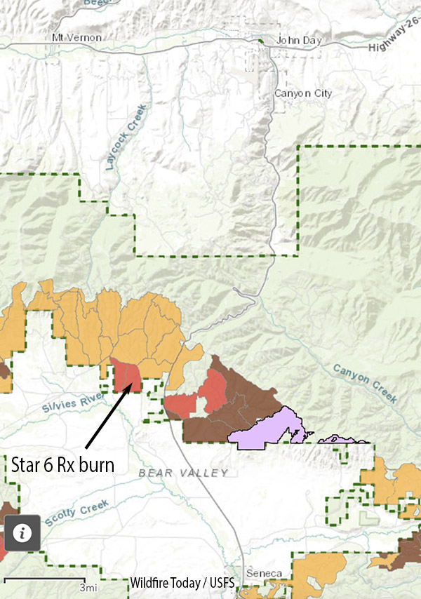
Map, location of Star 6 prescribed fire.
A US Forest Service employee serving as the Burn Boss on a prescribed fire was arrested Wednesday October 19 after the fire escaped and burned approximately 18 acres of private land.
The project was on the Malheur National Forest at mile post two on the Izee Highway between John Day and Seneca, Oregon.
Grant County Sheriff Todd McKinley issued a statement Thursday saying the escaped fire burned lands belonging to the Holliday Ranches on the “hot afternoon of October 19, 2022.”
The statement read in part:
The Grant County Sheriff’s Office arrested a 39-year-old Forest Service employee for Reckless Burning, and transported him to the Grant County Jail. The employee was assigned as the fire’s “burn boss.”
The Sheriff’s office said they are working with the Forest Service to determine the events that led to the escaped fire.
The Star 6 prescribed fire was intended to burn 362 acres. The US Forest Service said on Twitter the escape was caught within an hour at 18 acres, but failed to mention that the Burn Boss was arrested. The Sheriff said it burned approximately 20 acres.
Phone calls to Forest Supervisor Craig Trulock and Blue Mountain District Ranger Sally Christenson were not immediately returned.
This is the first time to this author’s knowledge that a Federal Burn Boss has been arrested for an escaped prescribed fire.
After the 2001 Thirtymile Fire, a Crew Boss was charged with 11 felonies related to the entrapment and burnover deaths of four firefighters who were on his hand crew. He was facing the possibility of decades in prison, but the Assistant U. S. Attorney, perhaps realizing he did not have a winnable case, allowed him to plead guilty to two misdemeanors of making a false statement in an Administrative hearing. Seven years after the fire, he was sentenced to three months of incarceration in a work-release program and three years of probation.
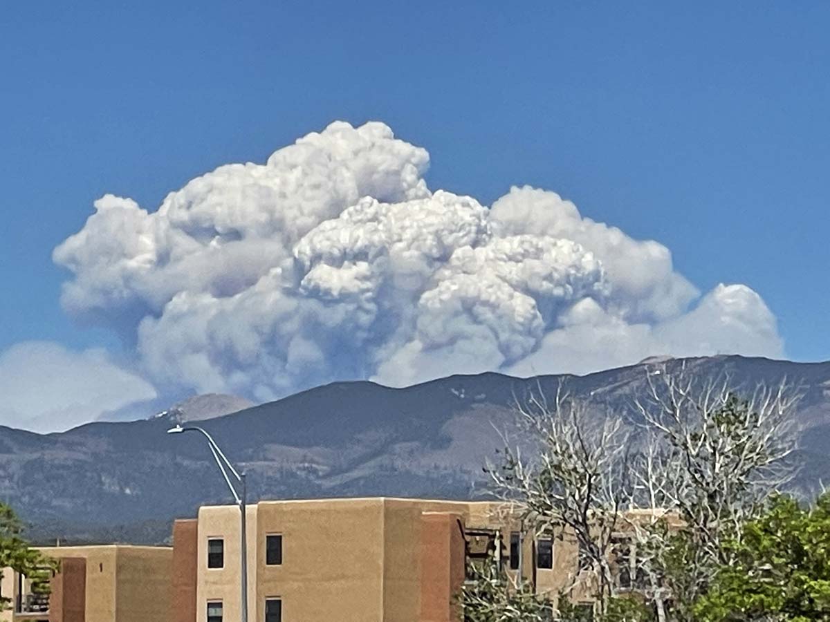
Test fire on the Las Dispensas prescribed fire on the Santa Fe National Forest in New Mexico, April 6, 2022. The prescribed fire later escaped, merged with another escaped prescribed fire, and burned more that 341,000 acres and 903 structures. USFS photo.
Forest Service Chief Randy Moore announced that the nearly four-month suspension on prescribed fires has been lifted after receiving the findings and recommendations provided by a National Review Team.
The suspension and review occurred after two prescribed fires on the Santa Fe National Forest in Northern New Mexico escaped in April, merged, and became the Calf Canyon – Hermits Peak wildfire that burned more than 341,000 acres and 903 structures. The area was later hit by flash floods which resulted in more damage. On September 18 the fire will transition from a Type 2 Incident Management Team to a Type 3 Team.
Calf Canyon – Hermits Peak Fire in northern New Mexico, May 10, 2022. Seen from Santa Fe. Photo by Allen Olson.
A report released by the Forest Service in June about the two escaped fires concluded the approved prescribed fire plan was followed for most but not all of the parameters. The people on the ground felt they were close to or within the prescription limits but fuel moistures were lower than realized and increased heavy fuel loading after fireline preparation contributed to increasing the risk of fire escape.
The National Review Team that evaluated the agency’s prescribed fire program produced a 107-page report which included seven recommendations. Chief Moore said in a statement, “I have decided to conditionally resume the Forest Service’s prescribed fire program nationwide with the requirement that all seven tactical recommendations identified are followed and implemented immediately by all Forest Service units across the country. These actions will ensure prescribed fire plans are up to date with the most recent science, that key factors and conditions are closely evaluated the day of a prescribed burn, and that decisionmakers are engaged in those burns in real time to determine whether a prescribed burn should be implemented.”
The seven recommendations in the report:
1. Each Forest Service unit will review all prescribed fire plans and associated complexity analyses to ensure they reflect current conditions, prior to implementation. Prescribed fire plans and complexity analyses will be implemented only after receiving an updated approval by a technical reviewer and being certified by the appropriate agency administrator that they accurately reflect current conditions.
2. Ignition authorization briefings will be standardized to ensure consistent communication and collective mutual understanding on key points.
3. Instead of providing a window of authorized time for a planned prescribed fire, agency administrators will authorize ignitions only for the Operational Period (24 hours) for the day of the burn. For prescribed fires requiring multi-day ignitions, agency administrators will authorize ignitions on each day. Agency administrators will document all elements required for ignition authorization.
4. Prior to ignition onsite, the burn boss will document whether all elements within the agency administrator’s authorization are still valid based on site conditions. The burn boss will also assess human factors, including the pressures, fatigue, and experience of the prescribed fire implementers.
5. Nationwide, approving agency administrators will be present on the unit for all high-complexity burns; unit line officers (or a line officer from another unit familiar with the burn unit) will be on unit for 30-40% of moderate complexity burns.
6. After the pause has been lifted, units will not resume their prescribed burning programs until forest supervisors go over the findings and recommendations in this review report with all employees involved in prescribed fire activities. Forest supervisors will certify that this has been done.
7. The Chief will designate a specific Forest Service point of contact at the national level to oversee and report on the implementation of these recommendations and on the progress made in carrying out other recommendations and considerations raised in this review report.
Chief Moore said two additional actions will occur by the end of this year:
Working with the interagency fire and research community and partners they will establish a Western Prescribed Fire Training curriculum to expand on the successes of the National Interagency Prescribed Fire Training Center headquartered in Tallahassee, Florida.
The Forest Service will identify a strategy, in collaboration with partners, for having crews that can be dedicated to hazardous fuels work and mobilized across the country to support the highest priority hazardous fuels reduction work.
Las Dispensas prescribed fire, 1:07 p.m. MDT April 6, 2022. USFS photo.
An 80-page report (4.7Mb) released by the U.S. Forest Service concluded that the management of the prescribed fire that escaped and merged with another escaped prescribed fire to become the largest wildfire in the recorded history of New Mexico, generally followed the approved prescribed fire plan for most but not all of the parameters. The people on the ground felt they were close to or within the prescription limits but fuel moistures were lower than realized and increased heavy fuel loading after fireline preparation contributed to increasing the risk of fire escape.
The prescribed fire on the Santa Fe National Forest in northern New Mexico east of the city of Santa Fe was one of the units within the Gallinas Prescribed Fire Project Area. The first burning activity in early October of 2017, was the ignition of piles of debris left after forest thinning projects. Less than expected snow allowed the fire to spread away from the piles over the next three months. In late December they began to suppress the fire, and on January 18, 2018 it was converted to a wildfire. A Facilitated Learning Analysis found that“communication” and “prescribed fire preparation and risk” were two common themes.
In a continuation of that large multi-unit project, on April 6, 2022 at 11:34 a.m. firefighters ignited the test fire on the Las Dispensas prescribed fire, expected to be 150 acres. At 12:34 p.m. the test was considered successful and the project commenced.
Test fire on the Las Dispensas prescribed fire April 6, 2022. USFS photo.
The first small spot fire occurred at 1:35, which was controlled. At 2:26 a quarter-acre spot fire was caught.
Radio communication with some of the personnel was discovered to be a problem. It was later found that Bravo Holding was using a separate “crew net” and were not monitoring the planned frequency.
Ignition stopped a couple of times as spot fires were suppressed, but by about 4 p.m. when the relative humidity dropped to 10 percent there were at least a dozen spots. At 4:06 the Burn boss requested contingency resources and at 4:15 as groups of trees began torching all resources were pulled off the fire due to the increasing fire intensity. At 4:25 Dispatch reported that the contingency resources were physically located in Taos, New Mexico at the Fire Summit (an annual training exercise). Taos is approximately 70 miles from the prescribed fire.
At 4:38 Dispatch advised the Agency Administrator that the Burn Boss and the Fire Management Officer recommend it be declared a wildfire — about four hours after the primary ignition began. The Agency Administrator made the wildfire declaration and at 4:50 the incident was named the Hermits Peak wildfire.
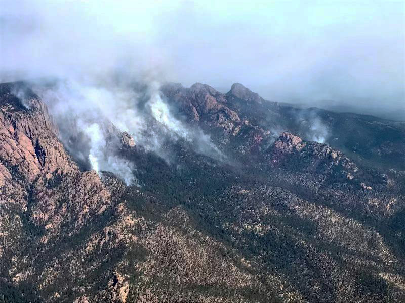
Hermits Peak Fire, April 8, 2022. USFS photo.
On April 22 the Hermits Peak Fire merged with the Calf Canyon Fire, another escaped prescribed fire on the Santa Fe National Forest. As of June 22 the blaze has burned more than 341,000 acres.
Weather
The prescription for broadcast burning required that the relative humidity be between 12 and 60 percent. The spot weather forecast issued by the National Weather Service at 8:53 a.m. on April 6 predicted the minimum RH would be between 9 and 13 percent, west winds 10 to 15 mph gusting to 25, and 54 to 58 degrees.
During the project on April 6 weather conditions were measured by a lookout once an hour using a hand-held Kestrel instrument. With that device the readings appeared to be within the prescription parameters except for the observations at 4 p.m. when it showed the RH had dropped to 10 percent.
From the report:
“Regarding temperature (dry bulb and wet bulb) and relative humidity, the observations recorded by the lookout showed a cooler and more moist bias when compared with other observations of weather and fire behavior on the site. Specifically, relative humidity readings taken from the Kestrel differed from what the relative humidity values should have been if calculated using the National Wildfire Coordinating Group standard tables for that elevation and the dry bulb and wet bulb observations. The relative humidity values recorded from the Kestrel provided values that are nearly 10 percent higher than those calculated.”
The recalculated RH at 4 p.m. was actually 6 percent, not 10 as shown on the Kestrel. One of the Firing Bosses also took readings and used the NWCG standard tables, which were similar to the recalculated values from the lookout’s Kestrel.
To summarize the weather, the forecast predicted the RH to be 9 to 13 percent, possibly below the prescribed 12 percent minimum, but it actually dropped as low as 6 percent, well below the prescription.
Fuels
Fine and heavy fuel loading increased in the years after the prescribed fire plan was developed, resulting from a combination of canopy opening from thinning (fine fuels) and fireline preparation (heavy fuels). This contributed to high fire intensity, torching, prolific spotting, and resistance to control.
The foliar fuel moistures were low and contributed to the transition from surface to crown fire. Fuel moisture samples taken from March 16 to April 3 showed a significant downward trend that contributed to the transition from surface to crown fire and increased spotting potential. Foliar moistures were listed to be sampled in the prescribed fire plan but were not part of the prescription.
The report’s conclusions, findings, and lessons learned
There was no nearby Remote Automated Weather Station (RAWS) in working order representative of conditions at the burn site. If available, the data could have improved situational awareness.
A thinning project in the burn area opened the canopy in some areas, allowing more sunlight which led to lower fuel moistures. Heavy ground fuels resulting from the construction of fireline for the burn project added to the fuel loading. This contributed to higher fire intensities, torching, spotting, and higher resistance-to-control.
Low live fuel moistures facilitated the transition from surface fire to torching and spotting outside the unit boundaries.
The prescribed fire plan mentioned that the Energy Release Component (ERC) which is an indication of the potential intensity of a fire, was to be monitored, but did not specify how the element would be used. On the date of the prescribed fire it was 37, far above average for the date which was 23. The highest ever recorded on that date was 41. Higher numbers indicate greater fire intensity.
There was an underestimation of the minimum holding and contingency resources needed. After numerous spot fires occurred, the Burn Boss requested the contingency resources, but they were 70 miles away.
A clear recognition and acknowledgment of long-term drought and climate factors versus short-term weather events would have led toward better situational awareness of the fire environment and could have resulted in more favorable outcomes.
The test fire was initiated in an area of the unit that was not representative of the rest of the unit. On several occasions, both before the burn was ignited and after the test fire was considered and accepted, some personnel felt that the dry conditions would result in difficult burning conditions and an increase in risk, but they accepted the assignment.
Consider requiring overhead, such as Firing Boss, Holding Boss and other staffed positions, to document support of the agreement with the Test Fire or the Go/No-Go decision.
Administrative boundaries limited the selection of potential control lines. The prescribed fire unit designation followed boundary lines from private property and other land designations, such as wilderness, and not necessarily advantageous fuels changes or topography.
Use the existing authority in the “Wyden Amendment” that allows managers of federal lands to spend funds to conduct treatments on adjacent non-federal lands to improve the viability of, and otherwise benefit, fish, wildlife, and other biotic resources.
District fire employees perceived pressure to “accomplish the mission,” which may have led to taking greater risk.
Records show the Prescribed Fire Burn Boss Type 2 (RXB2) performed as a fully qualified RXB2 at least 12 times since 2015.
Invest in education opportunities for continued learning in science and technology specific to fire behavior and fire environment. Consider workshops tailored for prescribed fire practitioners that address today’s challenges related to environmental and social conditions.
Prescribed fire programs and projects should invest in staffing, training, planning and other supporting resources commensurate with the priority and complexity of prescribed fire projects.
Consider Incident Management Teams when implementing complex prescribed fire projects.
Increase support for existing Burn Bosses by activating Planning Section functions when complexity warrants the additional capacity.
Establish an interagency training facility, such as the National Interagency Prescribed Fire Training Center, that would be located in the Western U.S. and focus on the additional complexities involved with western fuel treatments.
Learn from indigenous communities about cultural land management practices.
Invest in education opportunities for continued learning in science and technology specific to fire behavior and fire environment. Consider workshops tailored for prescribed fire practitioners that address today’s challenges related to environmental and social conditions.
And this from the report
“We ask them to make up ground on long-needed and far-behind proactive restoration work while barely allowing time to recover from a previously taxing wildland fire response and preparing to respond yet again. We ask them to restore fire process to ecosystems that have evolved to burn, but many of which are now primed for extreme fire behavior due to our own decisions to exclude or suppress fire in these areas.
“To accomplish this level and frequency of prescribed fire on the landscape, we must ensure that practitioners have access to the best science, technology and tools, and that they are confident and practiced in their usage. We need an approach to planning and implementing prescribed fire that’s as robust as our Incident Management Teams’ response to wildfire.”
The 10-year plan
The 10-year plan released in January by the Forest Service for prescribed fire and other fuel projects calls for tripling the number of acres treated on National Forest System Lands in the West and other Federal, State, Tribal, and private lands in the West, increasing from about 2.5 million acres a year to 7.5 million.
Our take
The report said, “District fire employees perceived pressure to accomplish the mission, which may have led to taking greater risk.”
If they feel pressure now, how will they feel when the number of acres treated needs to increase substantially? Will there be a corresponding escalation in Burn Bosses, Holding Bosses, full time prescribed fire planners, NEPA compliance capacity, crews, and weather windows?
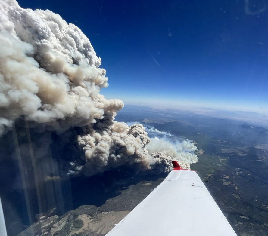
Hermits Peak – Calf Canyon Fire, June 14, 2022. USFS.
It later merged with the Hermits Peak Fire northwest of Las Vegas, New Mexico
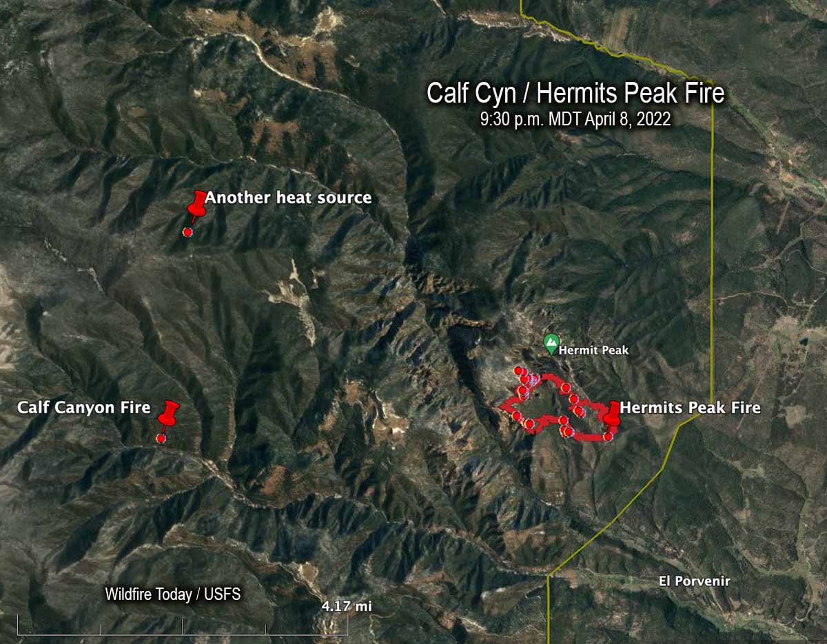
An April 8, 2022 map showing the Calf Canyon Fire before it grew large, another heat source nearby, and the Hermits Peak Fire.
The US Forest Service announced today that the Calf Canyon Fire northwest of Las Vegas, New Mexico was caused by piles that were still burning more than two months after they were ignited near the end of January, 2022. The heat remained after having been at times under snow when it was detected on April 9. The piles were comprised of vegetation and debris remaining after a fuel treatment project.
A statement released by the Santa Fe National Forest indicated that crews constructed a fireline around the 1.5-acre blaze on April 9 and “…continued to monitor the fire over the next couple of days to ensure there were no signs of heat or flames near the edge. Ten days later,” the statement continued, “on April 19 the Calf Canyon Fire reignited and escaped containment lines. A wind event on April 22 caused significant fire spread, and the Calf Canyon Fire merged with the Hermits Peak Fire, which was caused by an escaped prescribed burn.”
The term “reignited” is misleading. The burning piles were never completely put out. Wildfire Today found records showing that on April 8 fixed wing aircraft with thermal heat sensors began mapping the Hermits Peak Fire nearly every night the rest of the month. From imagery on April 8 at 9:30 p.m. MDT the Infrared Analyst noted two small heat sources both about 4 miles from the fire, one to the northwest and another almost due west which later became the Calf Canyon Fire. The heat to the northwest, 2.7 miles north of the Calf Canyon Fire, was not detected in subsequent mapping flights, indicating that it went out on its own or was successfully suppressed by firefighters.
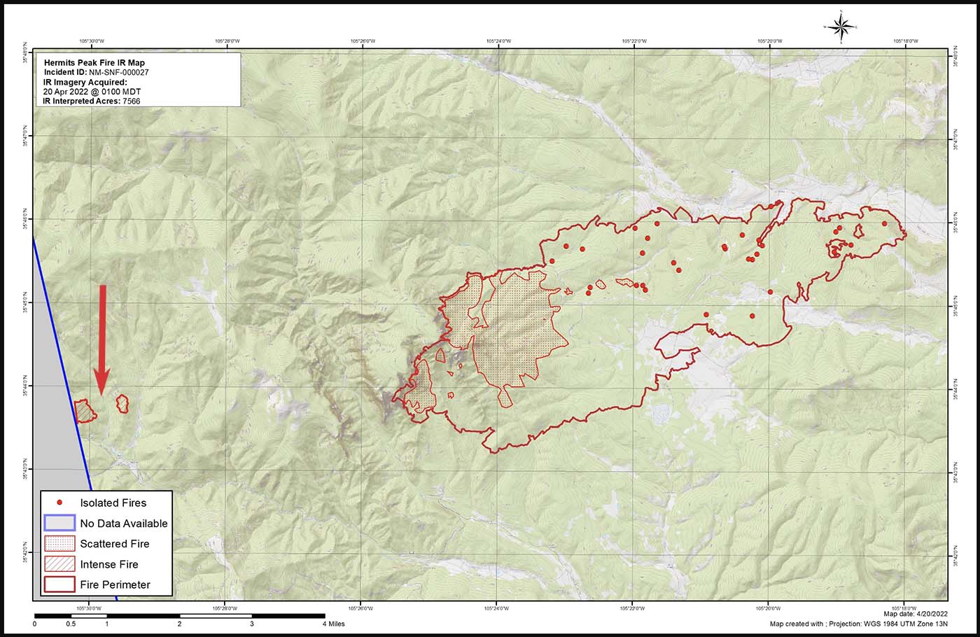
Map of the Calf Canyon and Hermits Peak Fires at 1 a.m. April 20, 2022 by the Incident Management Team. The red arrow, added by Wildfire Today, points to the Calf Canyon Fire which may have spotted, or there was an additional burn pile that spread.
Here are the results, related to what became the Calf Canyon Fire, of the Hermits Peak Fire aerial fire mapping from April 8 through April 21, 2022 (times are CDT):
8 @ 9:30 p.m.: heat noted at the pile burning site
9: (firefighters constructed line around a 1.5-acre fire spreading at the pile burning site)
10 @ 3 a.m.: heat noted
10 @ 10 p.m.: mapping mission unable to be filled (UTF)
11 @ 8:45: heat noted
13 @ 2 a.m.: not noted
13 @ 7:30 p.m.: not noted
14 @ 8:15 p.m.: not noted
15 @ 7:30 p.m.: not noted
16 @ 10 p.m.: UTF
18 @ 1:45 a.m.: not noted
18 @ 10 p.m.: UTF
20 @ 1 a.m.: intense heat noted at two locations at the pile burning site which were separately mapped by the Infrared Analyst. (See the map above. Either the fire spotted about 0.4 miles out ahead, or a second area in the pile burning project began spreading)
21 @ 1:30 a.m.: had grown to about 220 acres; was approximately half a mile wide and one mile long)
It is unknown if the mapping mission each night included the pile burning site four miles west of the Hermits Peak Fire, or if the Infrared Analyst was careful to examine the imagery for small detections of heat at the pile burning site.
After April 20 the Calf Canyon Fire was large and merged with the Hermits Peak Fire on the 22ndwhen both fires blew up. At that time the Hermits Peak fire was nearly contained and had been relatively quiet for several days, but pushed by very strong winds both fires ran 11 miles to the northwest in narrow parallel footprints until the wind speed decreased, allowing the flanks of both fires to spread laterally until they merged. The winds monitored at a weather station that day near Las Vegas, NM recorded sustained speeds of 40 to 50 mph with gusts up to 67 while the relative humidity dropped as low as 6 percent.
“We don’t have enough resources to do everything we want to do at one time so we have to prioritize the resources we have at the right location,” said Incident Commander Carl Schwope in a briefing on April 23.
The two merged fires, both the result of escaped prescribed fires and now called Calf Canyon / Hermits Peak Fire, are now 17 miles wide, 45 miles long, and have burned more than 312,000 acres, about 1/3 the size of Rhode Island. If you were driving from the south end of the fire at Las Vegas, NM on Highway 518 going north, it would take about an hour to reach the north edge of the fire near Angostura.