Wildfire northeast of Prince Albert, Sask. burns thousands of hectares, prompts evacuations

Cloverdale Fire

Updated 8:42 a.m. MDT May 19, 2021

Cloverdale Fire May 17, 2021
Cloverdale Fire May 17, 2021. Photo by Nicole Hansen.

Tuesday afternoon and into the evening the Cloverdale Fire a few kilometers northeast of Prince Albert, Sask. was active near Highway 55 where it burned across the highway north of the 780 road and spread into agricultural areas. The fields at that location and on the north side of the fire make it easier for firefighters to contain the blaze in those areas. (See the map below.)

Cloverdale Fire map
Map showing heat detected on the Cloverdale Fire by satellites, as late as 3:54 a.m. MDT, May 19, 2021.

The video below was aired Tuesday evening.

The weather forecast for Prince Albert on Wednesday is for increasing clouds with a west wind of 30 km/h gusting to 50, and the temperature steady near 9C.


5:09 p.m. MDT May 18, 2021

Map of the Cloverdale Fire
Map of the Cloverdale Fire, the morning of May 18, 2021.

A large wildfire just northeast of Prince Albert, Saskatchewan has burned thousands of hectares and prompted the evacuations of more than 35 homes. Tuesday morning Steve Roberts, vice-president of operations for the Saskatchewan Public Safety Agency said it had burned 3,694 hectares (9,128 acres). (See the map above.)

Prince Albert Mayor Greg Dionne said Tuesday morning that the fire had jumped across Highway 55.

Electrical power has been shut off for about 8,000 people.

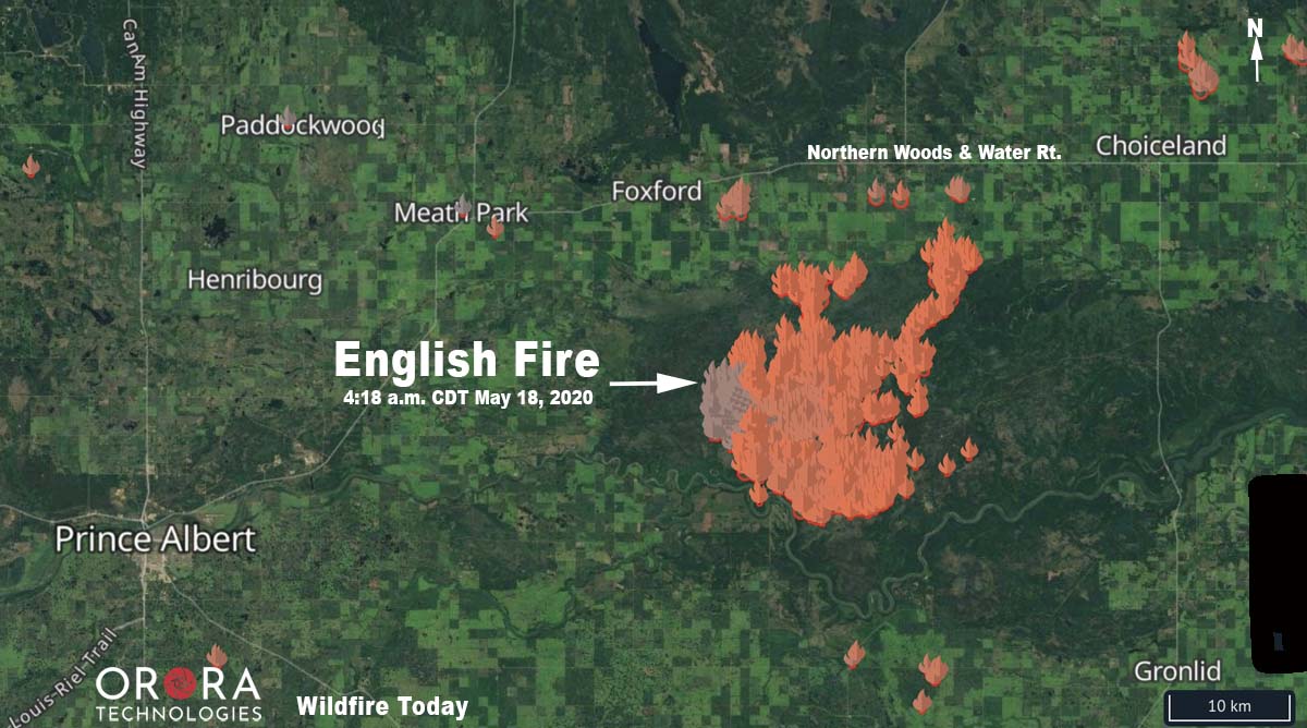
The English Fire burns over 71,000 acres east of Prince Albert, Saskatchewan

47 kilometers east of Prince Albert

map English Fire Prince Albert Saskatchewan
The map shows the location of heat detected by a satellite on the English Fire in Saskatchewan from May 8 through 4:18 a.m. CDT on May 18.

A wildfire named “English” by the Saskatchewan Ministry of Environment has burned over 71,000 acres (28,800 hectares) 30 miles (47 km) east of Prince Albert, Saskatchewan. GPS perimeter data was collected by the agency on May 16. The fire has been burning since May 8.

From Global News at 12:42 p.m. May 18, 2020:

The Saskatchewan government issued two wildfire alerts for communities northeast of Prince Albert on Sunday.

The alerts apply to the RM of Garden River the RM of Torch River specifically.

According to the government website the advisories were issued because of “wildfire[s] that [have] serious potential to cause emergency situations for the public.”
It said fires are burning in Fort a la Corne Forest and along the southwest edge of the Torch River area.

Residents in both rural municipalities are asked to “prepare and be ready to take action should an evacuation be required.”

The advisories say residents in Meath Park, Weirdale, Smeaton, Snowden and Shipman should close doors, windows and vents.

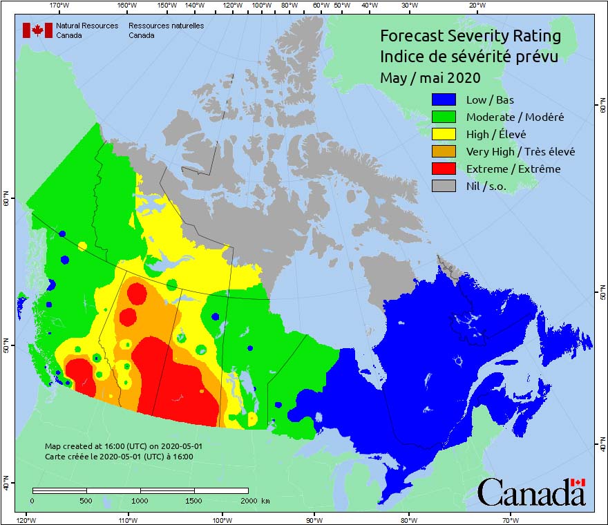
Increasing fire weather severity expected to bring extreme conditions to areas of Canada’s western provinces

Conditions in June and July are expected to be well above average.

Canada Fire Weather Severity forecast May, 2020

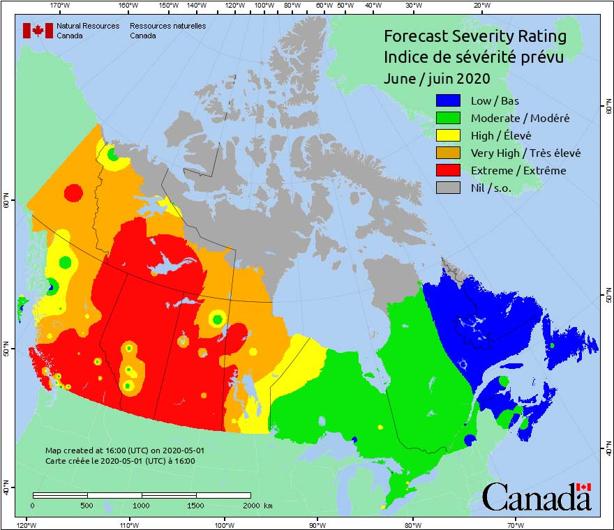
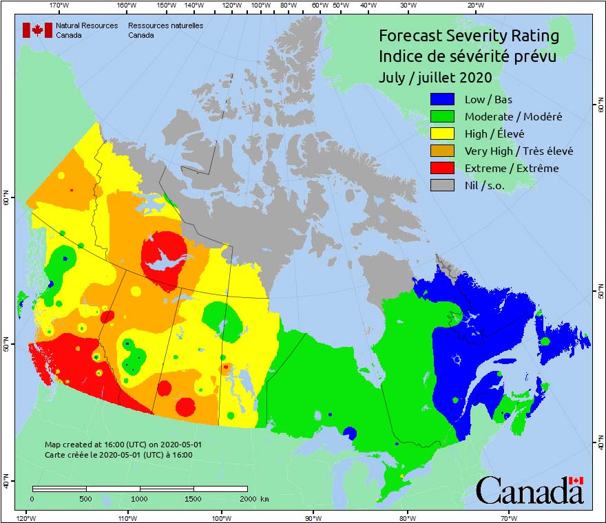
Forecasts are showing that fire weather severity in the western provinces of Canada will be increasing in May, and by June will be in the Extreme category in large areas of British Columbia, Alberta, Saskatchewan, and Northwest Territories.

Conditions in June and July are expected to be well above average, according to data from the Canadian Wildland Fire Information System provided by the Canadian Meteorological Centre, a branch of Environment Canada.

Canada Fire Weather Severity forecast June, 2020 Canada Fire Weather Severity forecast July, 2020

United States and Canada share firefighting resources

Above: Saskatchewan air tanker 474 lands at Medford, Oregon July 19, 2018.

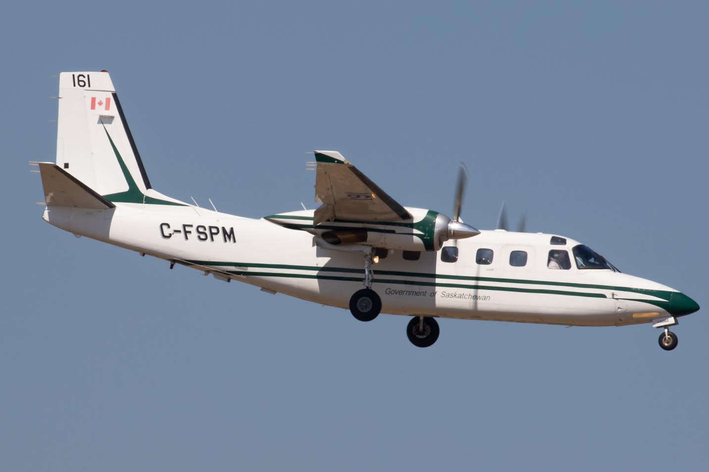
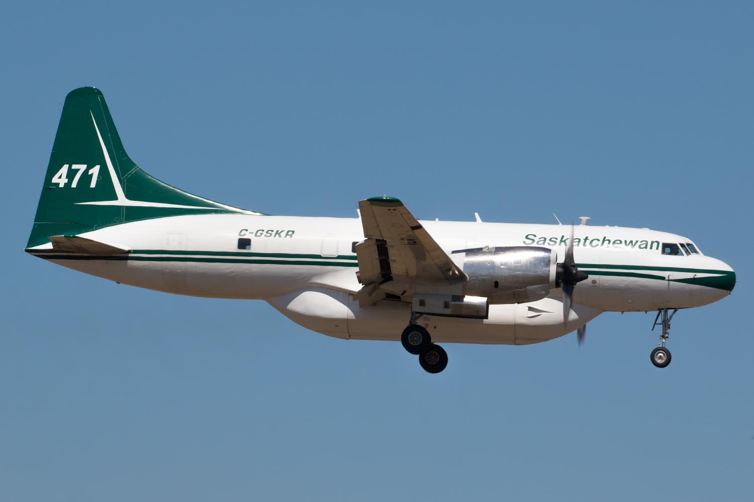
Tim Crippin shot these photos of firefighting aircraft arriving at the Medford, Oregon airport July 19. The two air tankers and the Bird Dog aircraft are owned by the government of Saskatchewan. The planes were mobilized through the Pacific Northwest Compact to Oregon; it was not an action that was taken by the National Interagency Coordination Center (NICC).

Saskatchewan Bird Dog 161
Saskatchewan Bird Dog 161 lands at Medford July 19, 2018.

The Canadians use “Bird Dog” aircraft in a role similar to lead planes in the United States. A Bird Dog usually works with two air tankers as a three-aircraft module. This one, 161, is an Aero Commander 690D.

Saskatchewan air tanker 471
Saskatchewan air tanker 471 lands at Medford, Oregon July 19, 2018

In addition to these three aircraft, other firefighting resources have been flowing across the international boundary in recent weeks from the U.S. to Canada:

  • NICC dispatched 12 wildland federal firefighters to Ontario, Canada.
  • The Northeast Compact sent resources to Ontario including three Type 2IA crews from New Hampshire, Maine and Massachusetts. However, the New Hampshire and Maine crews were demobed earlier this week and the Massachusetts crew will be demobed on Sunday.
  • Maine will be sending a second Type 2 IA crew to Ontario on Saturday.
  • The Great Lakes Compact has sent to Ontario 10 single resources (2 aviation managers and eight firefighters).
  • Wisconsin State will be mobilizing eight firefighters also to Ontario, Canada.

No aircraft have been sent to Canada from the U.S.

Precipitation reduces wildfire smoke in the central U.S.

Above: Snow cover in the United States, November 18, 2016. The Weather Channel.

Precipitation in the northwest quarter of the United States this week has put even more of a damper on the occurrence of wildfires, the execution of prescribed fires, and agricultural burning.

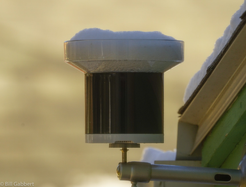
After weeks of warm, dry weather the Black Hills finally received a little precipitation over the last 24 hours. I won’t know the exact amount at my house until the snow in the rain gauge melts, but there was an inch or two of the white stuff on the ground. Today is sunny with a high of 32 predicted, so maybe it will trickle through the tipping bucket this afternoon.

snow rain gauge
Snow captured by my rain gauge since Thursday afternoon. Photo at 11 a.m. MT November 18, 2016 by Bill Gabbert.

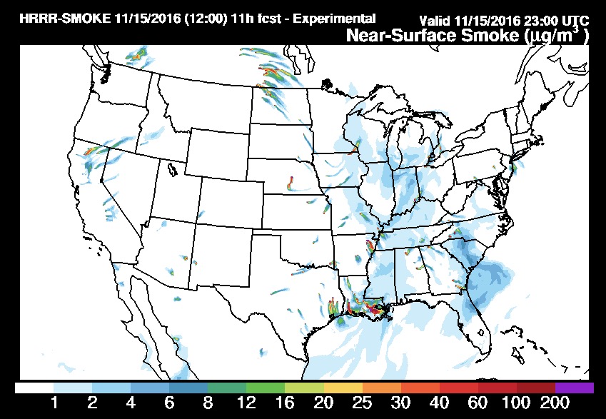
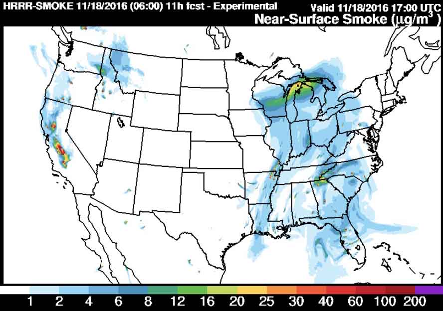
Small amounts of precipitation in southern Saskatchewan may be the reason smoke from that area is no longer immigrating into the United States, as you can see in the two maps below. The first one was the smoke forecast for November 15 and the one after that is for today, November 18.

wildfire smoke forecast
Prediction for the distribution of smoke from wildfires at 6 p.m. ET, November 15, 2016. Produced at 7 a.m. ET November 15.
wildfire smoke forecast
Forecast for wildfire smoke at 6 p.m. ET November 18, 2016, created at 1 a.m. ET November 18, 2016.

However, prescribed fires, wildfires, or agricultural burning in Louisiana, Arkansas, and eastern Texas are still producing large quantities of smoke that at times moves north into the midwest.

No rain is predicted until the middle of next week for the areas where wildfires are smoking out the residents in some areas of Tennessee, North Carolina, Georgia, and South Carolina.

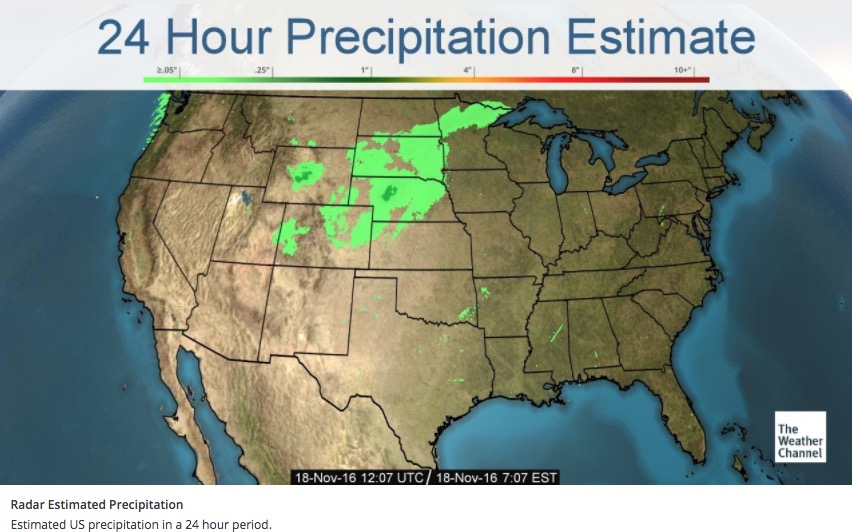
24 hour precipitation
Accumulated precipitation estimated by radar over the 24 hours before 7:07 a.m. ET November 18, 2016.


Wildfire briefing, July 15, 2015

Saskatchewan Premier wants a national fire cache and a fire mapping plane

The Premier of Saskatchewan, Brad Wall, wants the national government to establish a national cache of firefighting supplies and equipment that could be distributed when a province, or provinces, have multiple large fires ongoing. Perhaps he is thinking of a system similar to the one used in the United States, which has a national cache in Boise at the National Interagency Coordination Center.

“Some of those basic things that we would normally just call Manitoba or B.C. and say, ‘We need these things,’ well they were all fighting fires,” Mr. Wall said Wednesday. “Why, as a country, wouldn’t we have a cache? A national store to draw from if there is an occasion again where so many provinces are involved in fighting major fires?”

Mr. Wall also would like the see Canada acquire and operate a fire mapping plane that would use infrared detection equipment to see through smoke to map the perimeters and intensely burning areas of wildfires.

“If we could have at least one of those available nationally to provinces, because when it’s smokey, you have this whole flight … that’s grounded, and you might lose a little bit of ground that you might otherwise gain in better weather,” Wall said.

Wall will raise the idea at the premiers meeting in St. John’s, where he was heading on Wednesday.

Another drone shuts down aerial firefighting equipment

Sunday afternoon firefighting air tankers had to cease their operations on a fire near Yucaipa, California for about eight minutes when a drone was spotted over the fire.

Firefighting soldier takes bathroom break, gets lost for six hours

One of the 600 soldiers helping to suppress wildfires in Saskatchewan took a break to relieve himself Monday and didn’t return. His absence was noticed at 2 p.m. and a search began.

Below is an excerpt from an article at CBC.ca:

“I am happy to report, he is uninjured except for his pride, and many lessons, a number of lessons to be learned about this,” Brig.-Gen. Wayne Eyre said.

The Canadian Army said the soldier, one of some 600 from the Prairies deployed in the forest fire zone, had walked into the forest to relieve himself in privacy and got lost.

When others noticed he was missing at around 2:20 p.m. CST, a massive search began, involving soldiers, the Wildfire Management Centre, the RCMP, Canadian Rangers and other agencies.

The search virtually shut down firefighting in the area yesterday afternoon.

Eyre acknowledges that there should have been a buddy system in place, and the soldier, described as experienced, should have stayed in one spot.

Around 8:30 p.m., he was found.