Update on the Calf Canyon and Hermits Peak Fires in New Mexico

They have burned more than 60,000 acres

11:36 a.m. MDT April 26, 2022

Calf Canyon Fire map
Map of the Calf Canyon Fire after it merged with the Hermits Peak Fire. The red line was the perimeter at 2 a.m. MDT April 26, 2022. The white line was the perimeter about 24 hours before.

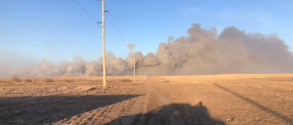
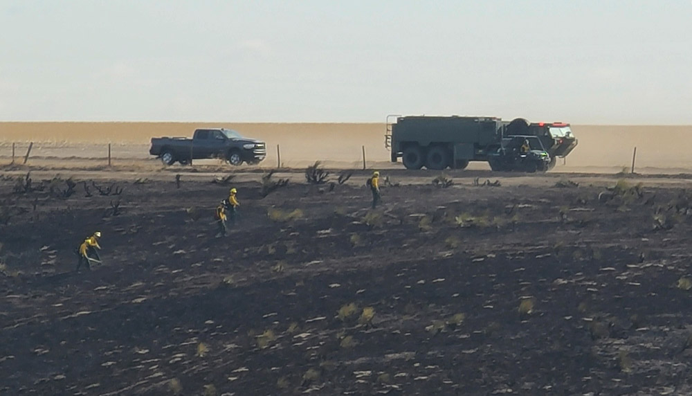
With more favorable weather conditions and less active fire behavior on the Calf Canyon and Hermits Peak Fires, on Monday firefighters were able to engage in operations in areas that had previously been difficult to reach safely.

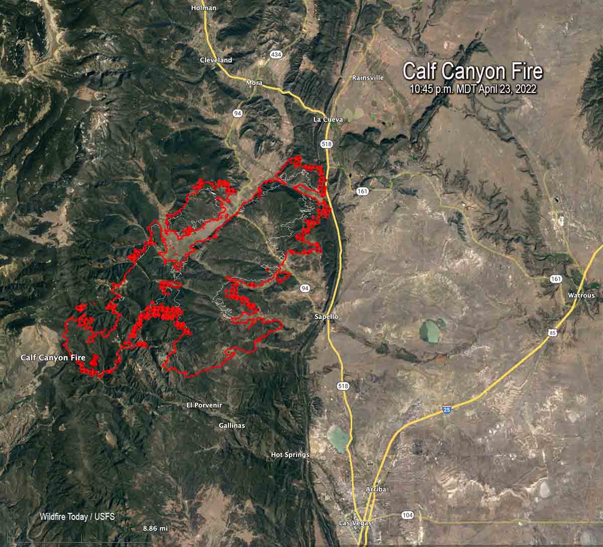
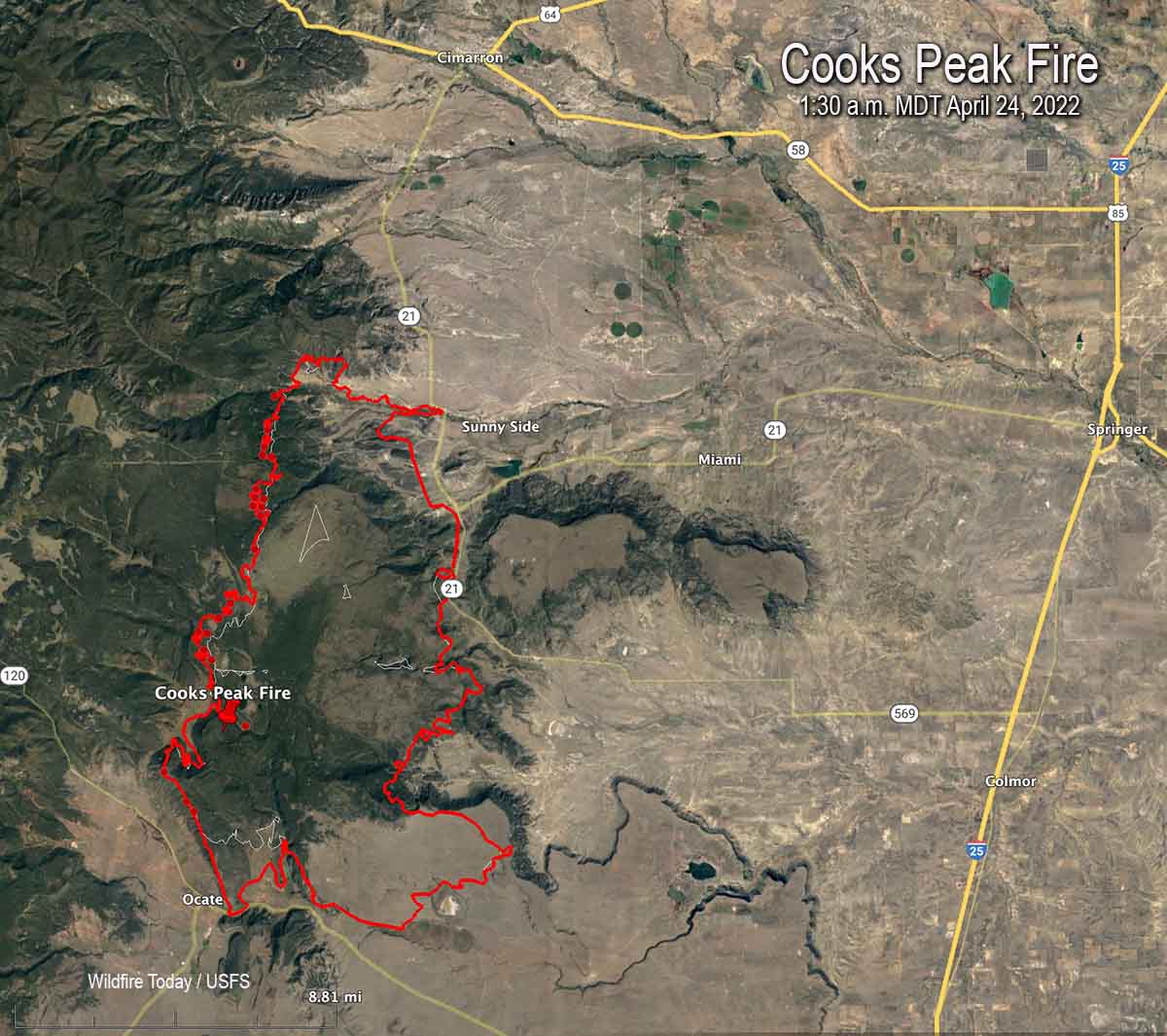
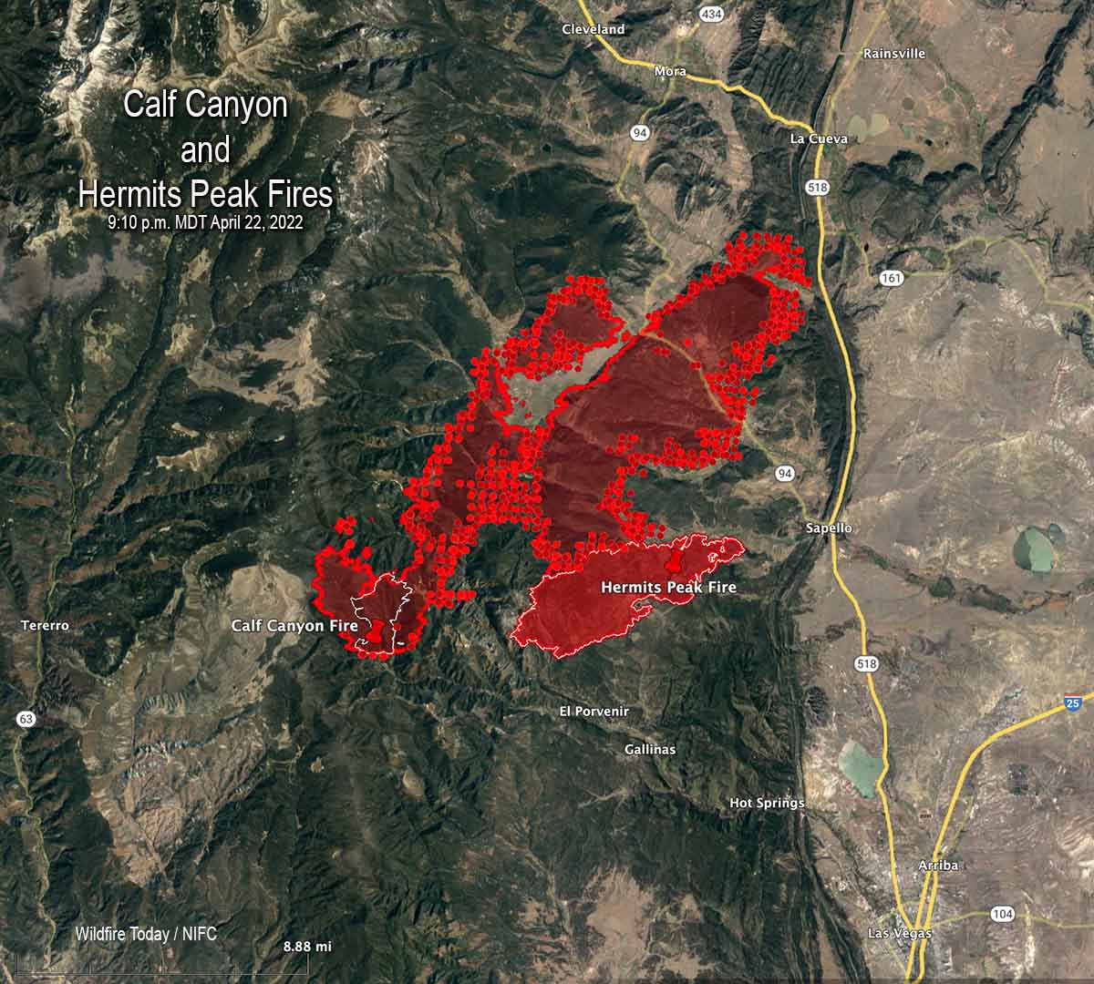
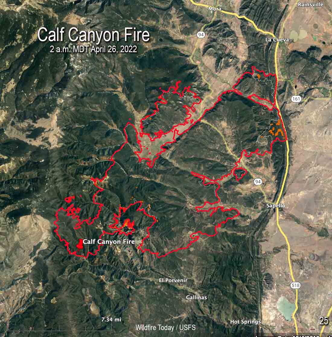
There was incremental growth on Monday. The fire was mapped by an aircraft at 2 a.m. MDT Tuesday and found to have burned 60,173 acres. That is the combined size of the two fires that merged.

Firefighters were able to engage aggressively across the fire area yesterday, capitalizing on the favorable weather conditions.

To see all articles on Wildfire Today about the Calf Canyon and Hermits Peak Fires, including the most recent, click HERE.

“Fire managers are determining where to focus resources based on weather, terrain, predicted fire behavior, and values at risk,” according to a statement issued by the Incident Management Team.”These decisions are based on the highest probability of success and flexible options in the event of sudden changes in weather or fire behavior.”

Law enforcement agencies are assessing impacts the fire had on structures and will be notifying property owners once confirmed.

CL-415 air tankers Calf Canyon Fire
Map shwing two CL-415 air tankers on the Calf Canyon Fire, April 26, 2022. The track of one, Tanker 283, is displayed. FlightRadar24.

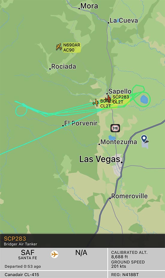
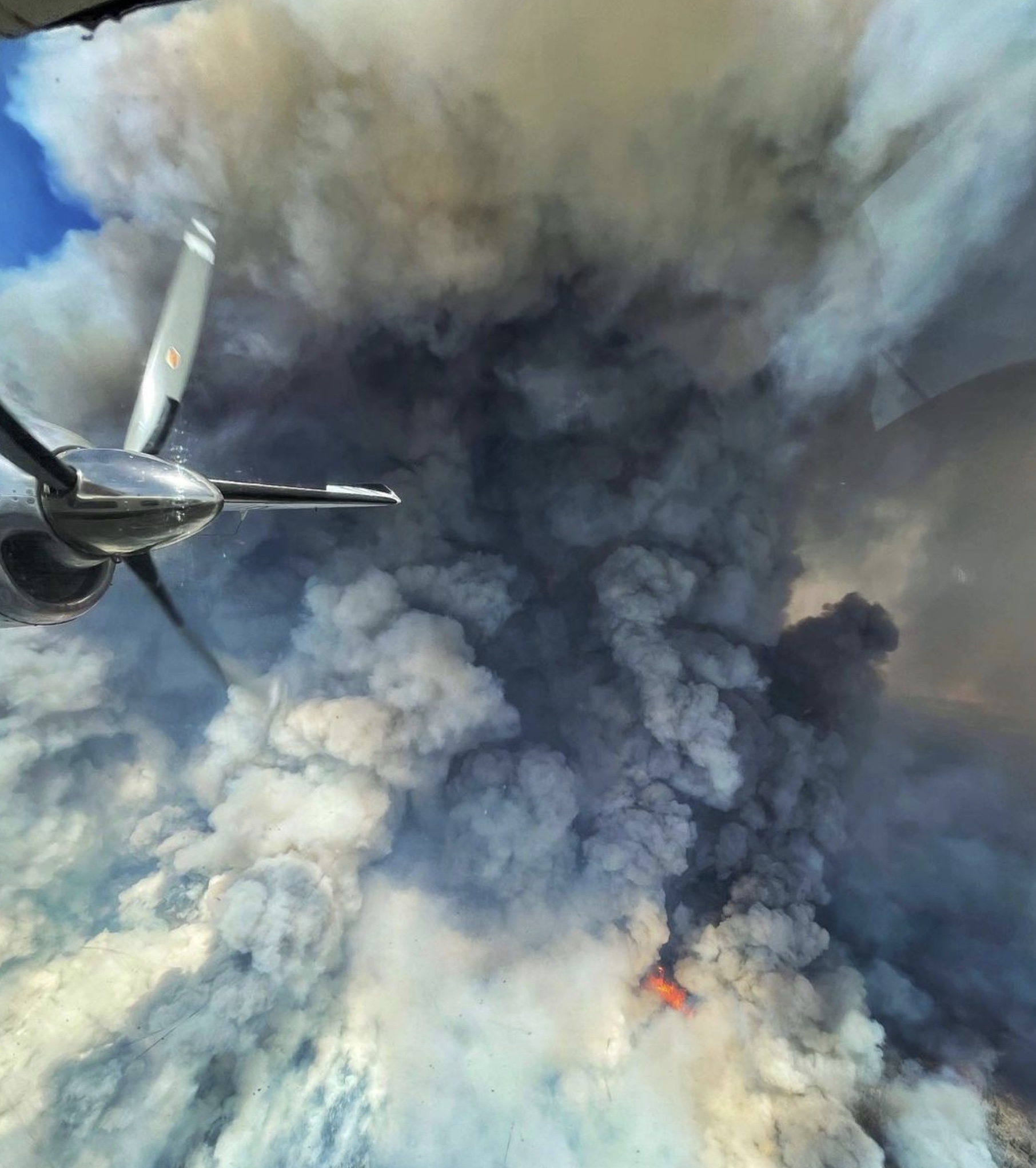
Beginning Monday and continuing on Tuesday, four water-scooping air tankers have been obtaining water from Lake Isabel and dropping it on the fire. To date, the scoopers along with other aircraft have delivered over 265,000 gallons. The lake is 8 miles east of the east side of the fire, which would be about a 5 minute one-way trip carrying up to 1,600 gallons of water. The map above shows the track of one of two CL-415 air tankers working the fire at 10:52 a.m. on Tuesday. An icon for a second CL-415 is also seen, but without its track — they often work in pairs.

Hermits Peak Fire Calf Canyon
Hermits Peak Fire by @jennalunaphoto

The wind will be out of the southwest at 20 mph Tuesday increasing to 24 with gusts to 32 on Wednesday. The forecast calls for the relative humidity to be in the high teens Tuesday, and on Wednesday in the 20s with a chance of thunderstorms and a small amount of rain.

North winds push Crooks Fire to the south

The fire is eight miles south of Prescott, Arizona

4:38 p.m. MDT April 25, 2022

Crooks Fire map, 3:15 a.m. MDT April 25, 2022

A wind from the north on April 25 pushed the Crooks Fire three miles to the south in Ash Creek, increasing the size to 5,893 acres according to a fixed wing flight very early Monday morning. The northern edge of the blaze is 8 miles south of Prescott, Arizona. The east side is about a mile west of the Goodwin Fire that burned about 28,000 acres in 2017 (see map above).

The north wind provided good conditions Monday to complete firing operations on the north side to prevent spread to the northwest into Lookout Mountain and Dosoris Canyon. Throughout the day and into the night, firefighters extended the fireline south of Lookout Mountain toward Ash Creek and from Moscow Peak west to Senator Highway.

Crooks Fire
Crooks Fire as seen from Mt. Union Lookout, April 23, 2022. IMT photo.

Fire managers are planning contingency lines south and west of the fire in case winds push the fire in those directions.

Resources assigned include 19 hand crews, 38 fire engines, and 12 helicopters for a total of 675 personnel.

Weather

At 3:30 p.m. MST Monday at the Prescott Airport (elevation 5,043) the relative humidity was 9 percent, the temperature was 72, and the wind was east-southeast at 3 mph. The elevation at the fire ranges from 5,000 to 7,000 feet.

The weather on Tuesday and Wednesday could produce an increase in the rate of spread of the fire. The forecast for the area on Tuesday is for 20 mph winds out of the south gusting around 30, with relative humidity in the teens and the temperature in the 60s. On Wednesday the conditions will be similar but with winds a little stronger, 23 mph gusting to 26 mph. Thursday will be about the same as Wednesday.

Satellite photo smoke Crooks Fire
Satellite photo showing smoke from the Crooks Fire at 3:01 p.m. MDT April 25, 2022.

Retired Fire Chief killed in Nebraska wildfire

National Incident Management Team mobilized

Updated 8:17 a.m. MDT April 26, 2022

Blackhawk helicopters Road 702 fire Nebraska National Guard
Blackhawk helicopters from the Nebraska National Guard drop water on the Road 702 Fire west of Cambridge. Incident Management Team photo.

Firefighters made good progress Monday on the Road 702 Fire in southwest Nebraska.

Most of the fire impacted grass and crop lands, but there are woody draws which have heavier fuels, especially on Beaver Creek along Highway 89 and near the Republican River south of US 34. Those areas are receiving more attention from firefighters as they are mopping up. Incident Commander Rob Powell said there will be smoke in those draws for a while.

The most recent map produced at 4 p.m. MDT April 25 shows an increase of about 300 acres to bring the total up to 41,448 acres, due to a four mile long finger of fire north of US 34 northeast of Bartley that was not detected during an earlier mapping flight. Fire crews have contained all of the fire north of the highway, including the additional acreage.

The fire started in Kansas on Friday April 22 during a wind event which pushed it north quickly into Nebraska where it continued running. The fire was 27 miles long when firefighters were able to stop it two miles southwest of the Medicine Creek Reservoir.


9:46 a.m. MDT April 25, 2022

Map Road 702 Fire Nebraska
Map of the Road 702 Fire at 1:42 p.m. MDT April 24, 2022.

A retired fire chief died in a Nebraska fire that has burned 41,155 acres in the southwest part of the state. The Road 702 Fire is west of the towns of Cambridge and Wilsonville and has crossed both US 34 and State highway 89. About 1,500 acres of the blaze is in Kansas.

Alyssa Sanders, with the Nebraska Emergency Management Agency, said 66-year-old John P. Trumble, of Arapahoe, was overcome by smoke and fire after his vehicle left the road Friday April 22 during conditions of poor visibility caused by smoke and dust. His body was found early Saturday. He was assisting firefighters by serving as a spotter in Red Willow County.

Road 702 Fire wildfire Nebraska
Road 702 Fire. Nebraska State Patrol drone photo.

Nebraska National Guard has mobilized three helicopters and several support trucks to help battle the fire.

A Type 1 Incident Management Team from the Rocky Mountain Geographic Area led by Incident Commander Dan Dallas assumed command April 24.

Stephanie Shively with the Incident Management Team said Monday morning that the resources on the fire include 9 engines, one 20-person crew, and the 3 National Guard helicopters for a total of about 100 personnel. They have outstanding orders for dozers and another hand crew.

Ms. Shively said the size of the fire has not changed since it was mapped Sunday.

We send our sincere condolences to the family, friends, and co-workers of Chief Trumble.

Road 702 Fire wildfire Nebraska
Road 702 Fire. Posted April 24, 2022 by Loomis Volunteer Fire & Rescue.
Road 702 Fire wildfire Nebraska
Nebraska Army and Air National Guard firefighters work the edges of a burned area near Hayes Center, Neb., April 24, 2022, to extinguish hot spots and prevent reignition. Photos courtesy of Capt. Joshua Miller.

More photos are below. Continue reading “Retired Fire Chief killed in Nebraska wildfire”

Forecast for wildfire smoke, April 24 & 25

In the crosshairs are portions of Arizona, New Mexico, Texas, Oklahoma, and Nebraska… for now

Forecast for vertically integrated wildfire smoke
Forecast for vertically integrated wildfire smoke at 5 p.m. MDT April 24, 2022. NOAA.

Above is the forecast from NOAA for the distribution of smoke from wildfires at 5 p.m. MDT April 24, 2022.

Below is the forecast for 3 a.m. MDT April 25, 2022.

Forecast for vertically integrated wildfire smoke
Forecast for vertically integrated wildfire smoke at 3 a.m. MDT April 25, 2022. NOAA.

Bookmark this page where the most recent articles about smoke on Wildfire Today can always be found:  https://wildfiretoday.com/tag/smoke/

Calf Canyon and Hermits Peak fires burn together, spread northeast for 10 miles

 Updated 8:53 a.m. MDT April 24, 2022

Calf Canyon/Hermits Peak Fire

Map Calf Canyon Fire
Map of the Calf Canyon Fire showing the perimeter in red at 10:45 p.m. MDT April 23, 2022. The white line was the perimeter about 24 hours before. The red dots represent heat detected by a satellite at 2:45 a.m. MDT April 24.

As the wind speeds decreased from the gale force conditions seen Friday, firefighters on the Calf Canyon and Hermits Peak fires that burned together were able to re-engage Saturday. The blazes are about 10 miles north of Las Vegas, New Mexico.

Crews are working on structure protection out ahead of the fire, removing fuel near homes in order to reduce their vulnerability. Dozers are putting in fire line where the terrain permits and the seven hand crews are working in steeper, less rocky areas.

Click to see all articles on Wildfire Today, including the most recent, about the Calf Canyon, Hermits Peak, and Cooks Peak fires.

Even though the fires have merged they are still being treated separately in reports. The combined size determined by a mapping flight at 10:45 p.m. Saturday was 54,004 acres.

“We don’t have enough resources to do everything we want to do at one time so we have to prioritize the resources we have at the right location,” said Incident Commander Carl Schwope in a briefing Saturday evening.

Hermits Peak Fire April 18, 2022
Hermits Peak Fire April 18, 2022 before it merged with the Calf Canyon Fire. By @jennalunaphoto

Reports filed Friday night showed that only seven hand crews were assigned and only one of those was a higher qualified Type 1 crew. A total of 526 personnel were on the fire.

The Incident Management Team that is handling both incidents has ordered “hundreds” of resources, but those orders can only be filled if the personnel and equipment are available.

As of Saturday evening the fire had not crossed the 518 road near the junction of road 161, but it was close and the fire was active in that area.

The Hermits Peak Fire was caused by a prescribed fire that escaped on the Santa Fe National Forest at 4:30 p.m. April 6, 2022. No cause has been released for the Calf Canyon Fire first reported on April 19.

Cooks Peak Fire

The Cooks Peak Fire nine miles south of Cimarron, NM was less active than the Calf Canyon Fire, but its spread was also slowed by a decrease in winds. A mapping flight Saturday night determined it had grown to 51,982 acres.

Map Cooks Peak Fire 130 a.m. MDT April 24, 2022
Map of the Cooks Peak Fire showing the perimeter in red at 1:30 a.m. MDT April 24, 2022. The white line was the perimeter about 24 hours before. The red dots represent heat detected by a satellite at 2:45 a.m. MDT April 24.

Reports submitted Friday evening showed there were only nine hand crews assigned, with one being a highest qualified Type 1 crew.  A total of 383 personnel were on the fire.


8:26 a.m. MDT April 23, 2022

map Calf Canyon & Hermits Peak Fires
Map of the Calf Canyon & Hermits Peak Fires. The red lines were mapped by an aircraft at 9:10 p.m. MDT April 22, 2022. The white lines were the perimeters about 24 hours before. The red dots represent heat detected by a satellite as late as 3:07 a.m.

Strong winds and low humidities combined to cause two fires to merge and spread 10 miles through dry vegetation in Northern New Mexico Friday. A third fire was also very active. Those fires have now burned a total of approximately 88,000 acres.

Continue reading “Calf Canyon and Hermits Peak fires burn together, spread northeast for 10 miles”

Wildfire smoke, April 22, 2022

4:37 p.m. MDT April 22, 2022

Vertically integrated smoke, 4 p.m. MDT April 22, 2022

Wildfires in Arizona and New Mexico plus fires in the Southeast are putting a large amount of smoke in the air. Strong winds in New Mexico and Colorado are dispersing smoke from the two large fires in New Mexico, Calf Canyon and Cooks Peak, keeping the those near surface plumes more narrow than they would be with slower wind speeds.

map Near surface smoke, 4 p.m. MDT April 22, 2022
Near surface smoke, 4 p.m. MDT April 22, 2022
Forecast for vertically integrated smoke
Forecast for vertically integrated smoke at 1 p.m. MDT April 23, 2022.

Vertically integrated smoke can be at any altitude. In some cases it might be only at high altitudes and may not be very noticeable at ground level. Near surface smoke will hover within 8 meters (26 feet) of the ground—the kind responsible for burning eyes and aggravated asthma.

Click to see all articles on Wildfire Today, including the most recent, about the Calf Canyon, Hermits Peak, and Cooks Peak fires.

This is where much of that smoke is coming from…..

Cooks Peak Fire
Cooks Peak Fire in New Mexico by @little_emilee6 April 21, 2022.