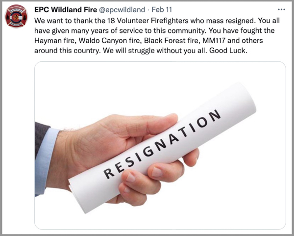
A tweet posted on the crew’s account said 18 volunteers “mass resigned”
A message posted February 11 on the Twitter account of the Wildland Fire Crew in El Paso County Colorado stated that 18 volunteer firefighters on the crew “mass resigned.” A follow up tweet read, “They said the environment became hostile to the volunteers and they felt they were no longer needed or wanted.” El Paso County is the location of Colorado Springs.
The El Paso County fire crew is part of the County Sheriff’s office which is headed by Sheriff Bill Elder. In Colorado and Wyoming the sheriff is responsible for the suppression of wildfires occurring in the unincorporated areas of the county outside the boundaries of a fire protection district. In Texas this role is assigned to the County Judge.
In a response to the tweets about the resignations, the Sheriff’s office issued a response to what they described as the “unauthorized, inaccurate tweet from the EPC Wildland Fire Twitter Account.” The response, posted below, said, “While there have been some resignations by members of the EPC Wildland Fire Team, the information posted was not accurate.” The statement did not specify what was inaccurate in the tweets about the resignations.
[pdf-embedder url=”https://wildfiretoday.com/wp-content/uploads/2022/02/MR-22-006-Sheriffs-Office-Addresses-Unauthorized-Inaccurate-Tweet-from-the-EPC-Wildland-Fire-Twitter-Account.pdf” title=”El Paso County Sheriff response to mass resignations wildland fire crew”]
El Paso County has been the location of some devastating wildfires in the last 20 years. In 2012, the Waldo Canyon Fire burned more than 18,000 acres, destroyed 347 homes in Colorado Springs, and killed two people. Almost exactly a year later, the Black Forest Fire ignited east of the city and burned more than 15,000 acres, 486 homes, and killed two people. The Hayman Fire in 2002 blackened 137,760 acres and destroyed 133 homes. In 2018 the MM 117 Fire burned 41,000 acres and 23 homes.
(UPDATE Feb. 17, 2022: KRDO has an article saying the Sheriff’s office told them that 10 members of the fire crew quit.)
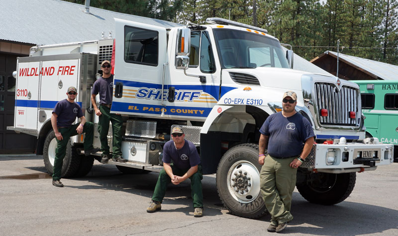
In 2014 while on a motorcycle trip that went through Northern California I took a photo of an engine crew from El Paso County that was staging in Chester.
El Paso County Sheriff’s Office engine crew in Chester, California, Aug. 16, 2014. L to R: Collin Wolff, Cameron Hammitt, Peter Ringen, and Captain David Yowell. Photo by Bill Gabbert.
The blaze burned 154 acres, coming very close to homes
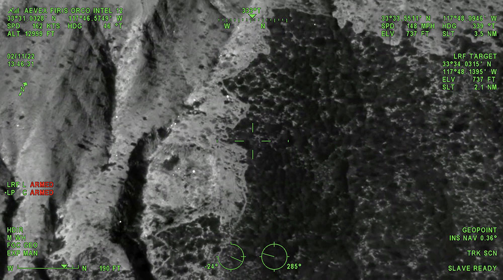
Still image from the video below of the Emerald Fire, from the FIRIS mapping aircraft at 1:46 p.m. PT Feb. 11, 2022.
The Emerald Fire near Laguna Beach, California was mapped by the Fire Integrated Real-Time Intelligence System (FIRIS) aircraft. The video below was recorded at 1:45 p.m. February 11, day two of the fire. The image switches back and forth from thermal infrared to regular video, with heat showing up as bright white. This data can help firefighters know where to concentrate their containment and mop up efforts.
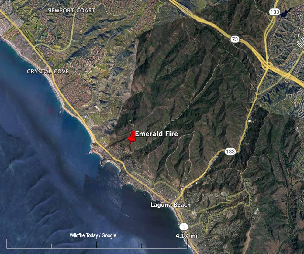
After the fire was reported Feb. 10, 2022 at about 4 a.m. in the Laguna Coast Wilderness Area, strong winds pushed the blaze near homes in the Emerald Bay area of the coastal city. It ultimately burned 154 acres, coming very close to homes, as you can see in the video.
In the aircraft were Peter Cain (Pilot), Matt Hedman of AEVEX on the controller, and Air Tactical Group Supervisor Steve Price providing narration.
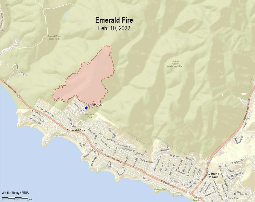
Map Emerald Fire, Feb. 10, 2022.Map showing the location of the Emerald Fire near Laguna Beach in Southern California, Feb. 10, 2022.
Yet it is is barely mentioned in the annual lessons learned review
Fatalities, wildland fires, 2021. (The number attributed to vehicle accidents should be 4.)
The Wildland Fire Lessons Learned Center (LLC) has released their annual review of incidents from last year, 2021.
The 10-page report discusses lessons learned from seven categories of injuries; dozer swamper, entrapment during initial attack, tree strike, entrapment during a burnout operation, crew vehicle rollover, hazard tree removal, and water tender rollover. It also mentioned other injuries — medical, feller-buncher, ATV rollover, drip torch, falling trees, rolling rocks, and dozer.
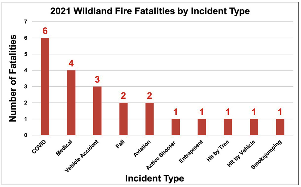
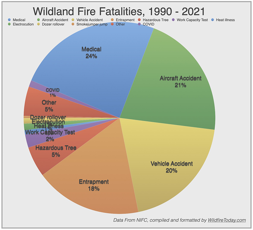
COVID was the leading cause of deaths on wildland fires in 2021
The LLC report states there were 23 fatalities, Line of Duty Deaths (LODD), connected to wildland fires in 2021. Six of those, 26 percent, were caused by COVID. That word appears twice very briefly in the report — in a chart showing COVID was the leading cause of Line of Duty Deaths on fires, and, in a word cloud showing that “COVID” was the single word mentioned more than any others in LLC incident reports in 2021. Other than that it is missing in the 2021 Incident Review Summary in spite of the six fatalities from the disease. It is not perfectly clear if the four fatalities described as “medical” had any relationship to COVID.
This annual report would have been an excellent opportunity for the LLC to summarize the most important lessons learned from COVID among firefighters over the last year. It could have identified innovative and successful methods for preventing fatalities and life-altering long-COVID, as well as policies that were not effective. It could have included important facts such as how many worker-days were spent in COVID isolation or quarantine on fires, how many firefighters tested positive during their fire and non-fire duties, and how many tested positive and were hospitalized.
If you go to the LLC website, if the database for reports is working and if you can master the search system, a person might find four reports from the summer of 2021 about “clusters” of COVID among hotshot crews, fuels modules, and engine crews. A total of 52 in these four clusters had to be quarantined and 14 tested positive. We summarized them in an August 21, 2021 article. There is no indication that these were the only COVID “clusters” in 2021.
Cameron Peak Fire, from the Estes Park Safeway October 16, 2020. InciWeb.
On the Cameron Peak Fire in 2020 west of Fort Collins, Colorado 76 workers at the fire tested positive for the virus and a total of 273 had to be quarantined at various times over the course of the fire. Two were hospitalized. And this is just at one fire.
I searched the LLC for COVID LODDs, but was disappointed to find there were only very brief boiler-plate firefighter fatality notifications from the U.S. Fire Administration (USFA). There were no identified lessons learned. I found out last year that in some cases the USFA was not afraid to identify the actual cause if it was COVID, when the federal agencies will sometimes, if they mention a cause at all, will just list it as an “unspecified illness.”
The USFA released the information that Allen Johnson was exposed to COVID-19 on the French Fire in California last year and tested positive along with others. His positive test was on August 24, and he was then placed in isolation at the incident. He was transported to the hospital on Aug. 31, 2021 where he passed away that day. That is not a typo. He died same day he was admitted to the hospital.
Fatality rates for COVID and influenza in the United States
We have all heard people say that COVID is just like the flu, people die from both. According to data from the New York Times retrieved February 9, 2022, 907,500 people in the U.S. have died from COVID, which is about 0.3 percent of the population. With 76,961,143 reported cases, that works out to a fatality rate for the disease of 1.2 percent.
During the 2019-2020 influenza season, the estimated number of deaths in the United States from influenza was approximately 20,000, or 0.06 percent of the population. The estimated number of people in the United States symptomatic of influenza was approximately 20,000,000, which would be a fatality rate for the disease of 0.1 percent. (These influenza statistics are from Wikipedia.)
The United States does a terrible job of accurately tracking COVID testing and fatalities, so these stats should be taken with a grain of salt.
Delays in releasing lessons learned reports
It is taking longer and longer for the US Forest Service to release reports about fatalities and near fatalities.
Burnover of 15 firefighters at a fire station on the Dolan Fire: 17 months.
Helicopter crash, 1 fatality and 2 serious injuries on a prescribed fire: almost three years.
How is COVID affecting federal firefighters?
I asked the US Forest Service several questions by email about their firefighting forces, including, what percentage of firefighters are vaccinated, how many have been terminated because they are not vaccinated, how many have been hospitalized with COVID, and how many people assigned to fires managed by the FS have tested positive while assigned to the fire and then died from COVID?
The response came from the Forest Service National Press Office. The person who wrote it was not identified. The office refused to disclose any of the numbers requested. “Reporting deaths if an employee dies outside of the workplace is voluntary,” they wrote. “The FS does not track how many employees have been hospitalized.”
Due to a court order, enforcement and disciplinary actions associated with non-compliance with the vaccine mandate for federal employees have been placed on pause. The Department of Justice appealed the preliminary injunction to the Fifth Circuit Court of Appeals, but it remains in place at this time. The Forest Service said employees who received a proposed suspension were officially notified of the pause. The injunction also pauses the requirement for new employees to provide COVID vaccination documentation prior to onboarding as a condition of employment.
Our take
The Forest Service appears to not be committed enough about workplace safety to even keep track of all of their personnel who are killed due to exposure to COVID while working for the agency. Or if they do keep track, they are lying when they report they don’t have the data. A motive for not caring or for hiding the fatality information is difficult to imagine.
A rational person would think that it is astonishing that Allen Johnson remained in isolation at the incident for eight days after testing positive, and then died the day he was admitted to a hospital. Hopefully an investigation is underway. Lives are at stake. What treatment, if any, did he receive at the fire or in isolation? Was he seen there by a doctor? Has the Medical Unit Leader been interviewed? Where was he isolated — in a tent at the fire, or a motel? What was his condition when he was admitted to the hospital? There were others at the fire who tested positive according to the USFA. What are their stories? I fought fires with Allen, so I would like to know more and how to prevent this from happening to other firefighters. Surely there are many lessons to be learned from this and other COVID-related tragedies.
The Forest Service needs to develop the courage to do the right thing for their people. When a firefighter is entrapped on a fire and injured or killed, a team of at least a half dozen subject matter experts will sometimes, but not always, try to honestly figure out what led to the incident and may develop suggestions for preventing others from suffering the same fate. Why are they scared to do the same for the fire personnel that died from COVID last year? Why are they refusing to be transparent about workplace hazards and their people being hospitalized and killed? What is the upside to the secrecy? What are they afraid of?
Already having severe problems recruiting and retaining employees, this type of uncaring management can only make it worse.
If the Forest Service refuses to conduct and release an honest investigation into the line of duty death of Allen Johnson, the chain of command from the Region 5 Director up through the Deputy Chief for State and Private Forestry and the Chief of the Forest Service should be fired.
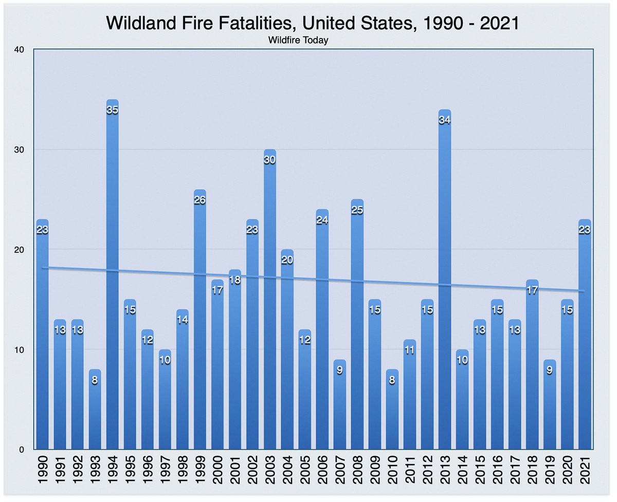
The charts below cover the 554 fatalities on wildland fires during the 32-year period ending in 2021.
The Terrace Fire is near Monte Rio, northwest of Santa Rosa
10:31 a.m. PST Feb. 11, 2022
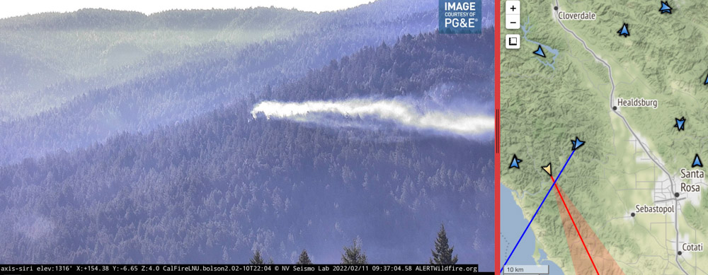
Using its spotlight, Sonoma County Sheriff’s Office helicopter Henry 1 directs firefighters to a fire near Monte Rio in Northern California. As seen from the Alert Wildfire camera at Siri, in infrared mode at 10:32 p.m PT Feb. 10, 2022.
Firefighters in Northern California had assistance from a Sonoma County Sheriff’s helicopter Thursday night as they were finding the best route to hike to the Terrace Fire near Monte Rio. It was reported at about 9 p.m. on a slope above Highway 116. The helicopter known as Henry 1 used its spotlight to direct the personnel as they hiked through the densely forested area.
When crews reached the blaze at about 11 p.m. they reported it had burned about one acre. Friday morning the Alert Wildfire camera at Siri showed that it is still generating a fair amount of smoke which is being blown close to the ground by the wind.
Image of smoke from a fire in Sonoma County near Monte Rio as seen from the Alert Wildfire camera at Siri, 9:37 a.m. PT Feb. 11, 2022. The intersection of the lines from the two camera locations indicate the approximate location of the fire.
The fire is about 14 miles west-northwest of Santa Rosa.
The Press Democrat reported Friday morning that Stephane Lunsford, a public information officer for CAL FIRE, said crews had completed a line around 85 percent of the fire.
Kent Porter (@kentphotos) shot some very interesting photos Thursday night. Here are a couple. Click on them twice to see larger versions:
Extremely tough access for fire crews Thurs. in a heavily forested area of Monte Rio, so @sonomasheriff Henry 1 illuminated the way for firefighters (it’s a walk in show to put the fire out). This is one of those times I backed off and looked for the artsy moment. @NorthBayNewspic.twitter.com/zjLYcZUYuG
A one-acre fire is not huge news. We don’t often hear about fires like this. But it’s an example of how firefighters are usually successful in keeping fires small, even when it requires hiking for hours at night through dense woods to find and then put out a fire.
In addition, it’s a fire in early February, far outside the traditional fire season in Northern California. But also the images are fascinating — the infrared photo showing the spotlight from the helicopter, smoke from the fire the next morning, and especially the great photos taken by Mr. Porter.
Hundreds of residents were evacuated before dawn Thursday
Updated at 10:08 p.m. PT Feb. 10, 2022
Map Emerald Fire, Feb. 10, 2022.
Thursday morning firefighters stopped the spread of the 145-acre Emerald Fire northwest of Laguna Beach in Southern California. At the peak of activity there were 220 personnel assigned, plus numerous helicopters and fixed wing aircraft.
All of the evacuation orders were lifted at 3 p.m. and no structures were destroyed. Areas in the interior of the fire are still burning, fire officials said Thursday afternoon, and the predicted hot, dry weather means they will have to continue to monitor, mop up, and improve containment.
The last time the area burned was during the Laguna Fire of 1993 which covered 14,337 acres, enveloping almost the entirety of Crystal Cove State Park and Laguna Coast Wilderness Area.
A spokesperson for the fire said good clearance of vegetation around the homes made it much easier for firefighters to prevent any structures from burning.
Fire personnel will be on scene Thursday night and fresh troops will arrive Friday morning.
1:04 p.m. PT Feb. 10, 2022
Map showing the location of the Emerald Fire near Laguna Beach in Southern California, Feb. 10, 2022.
Evacuation orders for the Emerald Fire prompted hundreds of residents in Laguna Beach in Orange County, California to leave their homes before dawn Thursday. Reported at about 4 a.m. in the Laguna Coast Wilderness Area, strong winds pushed the blaze near homes in the Emerald Bay in the coastal city.
As the fire was spreading, a weather station at Moro Canyon recorded 15 to 22 mph winds gusting out of the north-northeast up to 43 mph while the relative humidity was 31 percent. Those conditions are conducive to rapid fire spread and would have pushed the fire to the south-southwest. When the winds subsided later in the morning firefighters were able to stop the spread. Preliminary estimates put the size at about 140 acres, but that could change with more accurate mapping.
“We no longer have a fire season. We have a fire year,” said Orange County Fire Authority Chief Brian Fennessy in a news conference Thursday morning. “It’s February 10. This is supposed to be the middle of winter and we’re anticipating 80 to 90 degree weather. Even though the hillsides are green it doesn’t take but low humidity and wind to cause fires to occur. If this is any sign of what’s to come throughout the rest of the winter and spring we’re in for a long year.”
Two weather advisories are in effect for much of Southern California on Thursday, including the Emerald Fire area; one is for wind and another for heat. The forecast for the Laguna Beach area for Thursday morning called for northeast winds of 15 to 25 mph with gusts to 45. The heat advisory predicted high afternoon temperatures of 91 degrees.
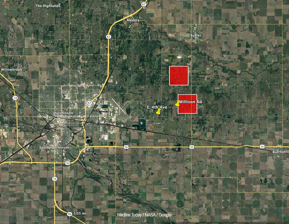
The Hutchinson Fire Department said in a news release Wednesday morning that the fire east of the city, now named the Albright Fire, was about 90 percent contained.
Pushed by strong winds, the fire which started south of Buhler ran south for about two miles from 30th Avenue to 4th Avenue. Firefighters worked Tuesday night and by morning all roads had reopened but burnout operations may cause temporary closures of some streets.
Fire Marshal Michael Cain has been investigating the fire to determine the cause, which is still believed to be embers from some of the 75 brush piles that were ignited on private land last Thursday when snow was on the ground. Warmer weather melted the snow rapidly and at least one of the piles spread Tuesday during the strong winds as the humidity dropped to 13 percent.
Damages to property and the total number of acres burned was still being determined Wednesday morning.
Updated at 12:37 a.m. CST Feb. 9, 2022
The winds that had been gusting at more than 30 mph slowed after 6 p.m. on Tuesday making it much easier for firefighters to begin to get a handle on a large wildfire a few miles east of Hutchinson, Kansas. Combined with relative humidity that dipped as low as 13 percent the strong winds resulted in the fire spreading south for nearly two miles from where it started just south of 30th Avenue near Buhler Road.
From the Hutchnews:
“By the time we got there, it was already running north to south,” Fire Chief Steve Beer said. “Numerous departments were called in to help with structure protection. We started an early evacuation of two or three dozen homes. We got everyone safely evacuated who wanted to leave.”
The evacuation was primarily in homes along Fourth Avenue, Beer said. It wasn’t a mandatory evacuation, so not everyone left.
“The fire didn’t move that fast,” Beer said. “But when it got in the cedars it would throw flames 50 feet into the air. It’s pretty impressive to watch. We’re thankful, it was not as bad as it could have been. The key to this area is to do back-burns. Once we did get ahead of it with enough resources, we got a handle on it.”
Fire officials said the likely cause was embers from woodpiles that were burned over the weekend.
As the weather conditions moderated, by 7 p.m. Tuesday some firefighting resources were being released and residents were expected to be back in their homes later in the evening.
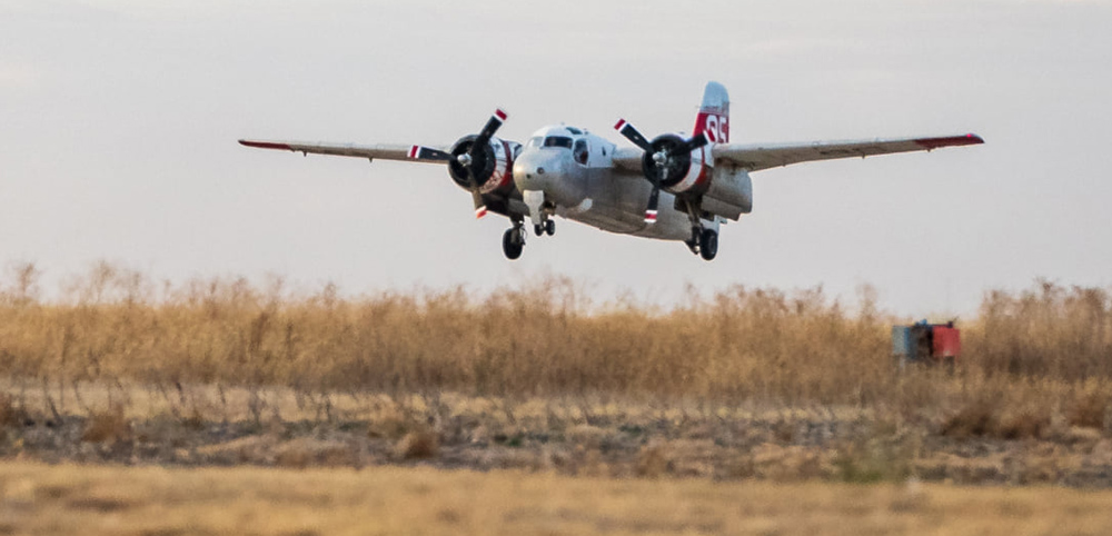
Chief Beer said the S-2 air tanker aided firefighters by attacking the blaze in areas that were difficult for them to access due to sandy soils and cedar trees.
Originally published at 5:44 p.m. CST Feb. 8, 2022
The map shows red squares that represent the approximate locations of heat at a fire detected east of Hutchinson, Kansas by the GOES-16 satellite at 2:40 p.m. CT Feb. 8, 2022.
Firefighters are working to contain a large wildfire about three miles east of Hutchinson, Kansas. Strong winds out of the north gusting to 36 mph are pushing the blaze to the south.
Crews are working to save structures near the intersection of East 4th Avenue and Williston Road.
The area is under a Red Flag Warning for high fire danger due to the powerful winds. The relative humidity was measured at 13 percent in Hutchinson at 4:52 p.m. The National Weather Service expects the wind speeds to decrease after sundown.
The fire is approximately three miles east of Hutchinson, about 2 miles south of Buhler, and 32 air miles northwest of Wichita.
Air tanker 95, a privately owned S-2, was dispatched to the fire. It is operated by Ag Air Service out of Nikerson, Kansas.
Air Tanker 95, an S-2. Kansas Forest Service photo.