The fire named “Colorado” has burned about 700 acres near Highway 1 near the California coast
Updated at 7:11 p.m. PT Jan. 22, 2022
Smoke drifts away from the Colorado Fire as the sun sets. Photographed by the Keig/Yankee Point camera looking south at 5:24 p.m. Jan. 22, 2022.
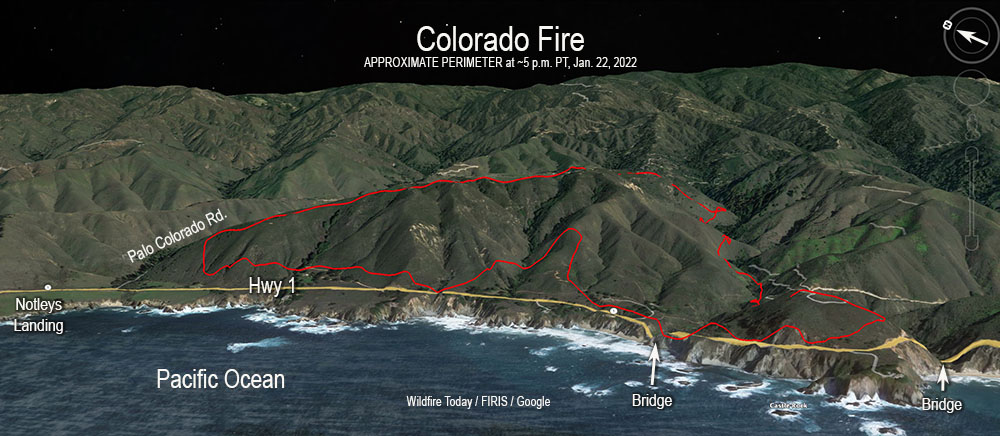
The Colorado Fire north of Big Sur, California was mapped at 683 acres by the Fire Integrated Real-Time Intelligence System (FIRIS) aircraft at about 5 p.m. Saturday. This is less than half of the earlier 1,500-acre estimate by the California Department of Forestry and Fire Protection. Fires look larger at night and the terrain at the fire scene is very rugged and difficult to map from the ground.
Colorado Fire, 3-D map, approximate location, looking east at 5:24 p.m. PT Jan. 22, 2022.Colorado Fire vicinity map 5:24 p.m. Jan. 22, 2022. Showing part of the footprint of the 2016 Soberanes Fire.
A satellite overflight at 1:22 p.m. local time showed that the fire had spread on the south side near Rocky Creek and on the northwest side southeast of Notleys Landing south of Palo Colorado Road. There has been no indication that the fire has crossed Highway 1, reached the coast, or made any large runs on Saturday afternoon. The fire cameras in the area did not pick up any large smoke columns.
1:04 p.m. PT, Jan. 22, 2022
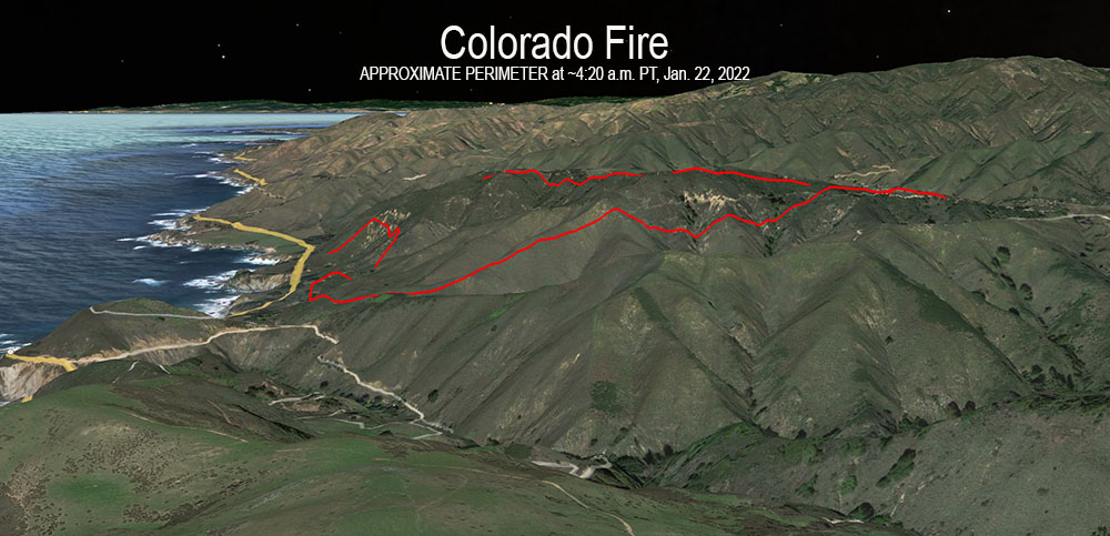
Colorado Fire, 3-D map showing the APPROXIMATE perimeter at about 4:20 a.m. PT Jan. 22, 2022. Looking north.
A wind-driven wildfire that broke out Friday afternoon north of Big Sur, California has prompted evacuations. The fire just east of the Pacific Coast Highway has forced residents to leave their homes and officials to close a portion of the iconic highway.
The blaze started near Palo Colorado Canyon Road which led firefighters who usually name a fire after a local landmark, to call it the “Colorado Fire.” (A name which will likely result in confusion.)
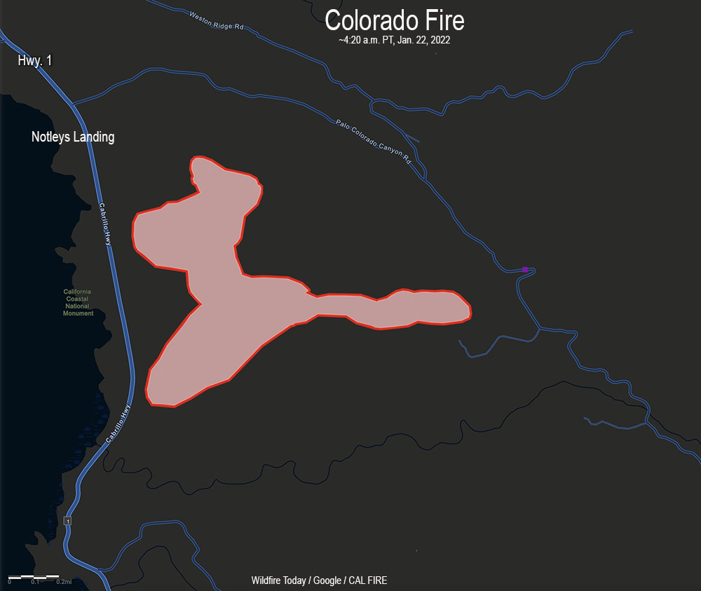
Colorado Fire vicinity map ~420 a.m. PT Jan. 22, 2022.
Monterey County has created a map showing evacuations in effect.
The incident is nine air miles north-northwest of Big Sur and seven air miles south of Carmel Highlands.
At 8:19 a.m. on Saturday the California Department of Forestry and Fire Protection said it had burned about 1,500 acres, but that figure is subject to change. At 12:30 p.m. PT there were several CAL FIRE S-2T air tankers flying near the fire.
The Colorado Fire was pushed Friday evening by very strong winds out of the northeast, measured at 41 mph gusting to 52 mph at 5 p.m. at the Old Coast Tower weather station east of Point Sur. The relative humidity was 21 percent. This caused the fire to spread west and southwest, cresting the ridge east of the Pacific Ocean; then the wind shifted. After 9 p.m. it decreased to 10 mph from the south and southeast. Around dawn on Saturday it shifted again, from the north and northwest at 5 to 8 mph. Overnight the humidity rose to 60 percent but dropped to about 30 percent at 11 a.m.
Colorado Fire map at about 4:20 a.m. PT Jan. 22, 2022.Colorado Fire, Jan. 22, 2022. CAL FIRE photo by David Hudson.
They were working on the Coles Fire northwest of Coonawarra
Map showing the location of heat detected on the Coles Fire at 1605 UTC Jan. 20, 2022 in South Australia.
One firefighter working on the Coles Fire in South Australia has been killed and another hospitalized, the state’s Country Fire Service announced on Friday. The agency said “they were involved in a falling tree incident.”
In a news release the Country Fire Services said, “Family and other personnel have been informed and are being offered support at this time. The seriously injured CFS member has been taken to hospital for further treatment. The safety and wellbeing of our people is our highest priority and our thoughts are with our CFS family at this time.”
From The Guardian:
One firefighter has died and another has been seriously injured after a tree collapsed on a fire truck battling an out-of-control bushfire in South Australia’s south-east.
The incident occurred at the firefront at Coles, near Lucindale, where the blaze was running uncontrolled through bluegum plantations, scrub and grassland, a spokeswoman for the state’s Country Fire Service said.
The Coles Fire, first reported January 19, has burned 3,835 ha (9,476 a) about 28 km (17 miles) west-northwest of Coonawarra in southeast South Australia.
Data from the U.S. National Interagency Fire Center in 2016 showed that in the United States hazardous trees was the fifth leading cause of wildland firefighter fatalities, behind medical, aircraft accidents, vehicle accidents, and entrapments.
Our sincere condolences go out to the family, friends, and co-workers of the two firefighters.
At least one large air tanker was used on the fire, including the RJ85 seen above.
Originally published at 9:03 p.m. Jan. 19, 2022
Rolling Pines Fire, Jan. 18, 2022. Mario V.
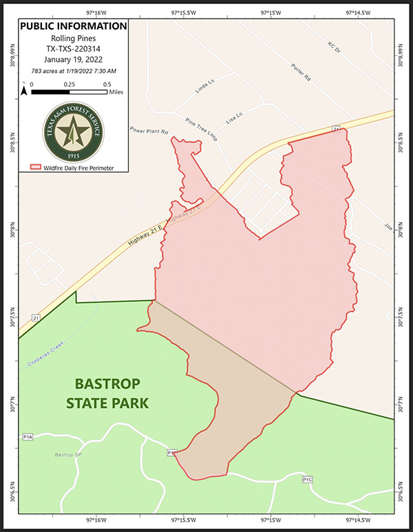
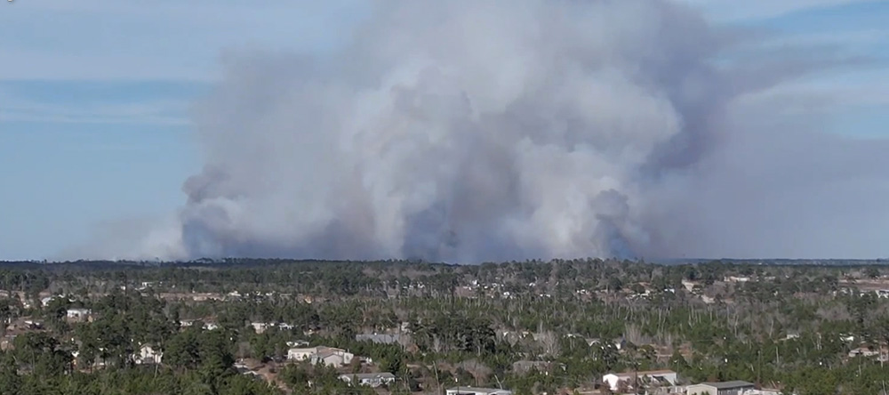
A prescribed fire in Bastrop State Park 28 miles southeast of Austin, Texas escaped on Tuesday. County Judge Paul Pape said 250 families were required to evacuate as the fire that was intended to burn 150 acres grew to 783 acres by Wednesday morning. At 6 p.m. Wednesday some of those residents were allowed to return to their homes. The fire was named “Rolling Pines Fire.” There were no reports of injuries or any residences that burned.
At 10:30 a.m. on Tuesday Texas Parks and Wildlife Department initiated the prescribed fire at the State Park. Shortly after noon spot fires occurred outside the area that was intended to be burned, according to Carter Smith, Executive Director of Texas Parks and Wildlife.
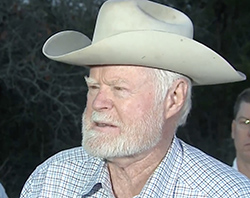
Texas is one of a few states that designate a county judge or sheriff, rather than fire professionals, to be *responsible for suppression of wildfires outside of incorporated cities. In Texas, judges take on that role. In a news conference County Judge Paul Pape said he is responsible for emergency response in Bastrop county.
Basrop County Judge Paul Pape. KXAN.
Judge Pape was asked by a reporter in a news conference Tuesday why on a day when local fire departments were advising residents to not do any outdoor burning due to strong winds, the state park decided to conduct the prescribed fire. He deferred the question to Carter Smith, Executive Director of Texas Parks and Wildlife, who said, “It is my understanding that we were well within the prescription of the weather parameters that were called for in the plan.”
Judge Pape said, “Based on everything they knew this morning, it was an appropriate day to burn. None of us can predict the weather more than 15 minutes ahead of time, and sometimes things happen we just don’t anticipate. I’m not going to be critical of the efforts to protect our citizens from wildfire by using prescribed burns. I think it’s a great tool and one that we need to continue to encourage people to use.”
A weather station near Bastrop, BTRT2, at 12:08 p.m. on Tuesday January 18 recorded sustained wind speeds of 16 mph with gusts up to 25 mph out of the south-southwest while the relative humidity was 53 percent. During the next four hours the RH dropped to 40 percent with south winds of 13 mph gusting to 23 mph. The 10-hour time lag fuel moisture during that time dropped from 11 percent to 8 percent.
With gusts over 20 mph it can be very difficult to keep a prescribed fire contained.
*In Colorado and Wyoming the County Sheriffs have responsibility for suppression of fires outside incorporated cities.
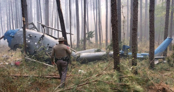
The National Transportation Safety Board has released their factual report on the crash of an AS350 helicopter that occurred March 27, 2019 during operations on a prescribed fire in Texas. Three people were on board, a pilot and two firefighters. The surviving firefighter and pilot were able to exit the helicopter; however, the second firefighter was partially ejected and sustained fatal injuries. The pilot suffered serious injuries and the surviving firefighter’s injuries were minor. The two injured personnel were transported to a hospital in stable condition after rescuers extracted them from the wreckage using jaws and air bags.
Daniel J. Laird. Tahoe National Forest photo.
The firefighter killed was Daniel Laird, a Captain on the Tahoe Helitack crew in California. He left behind a wife and young daughter.
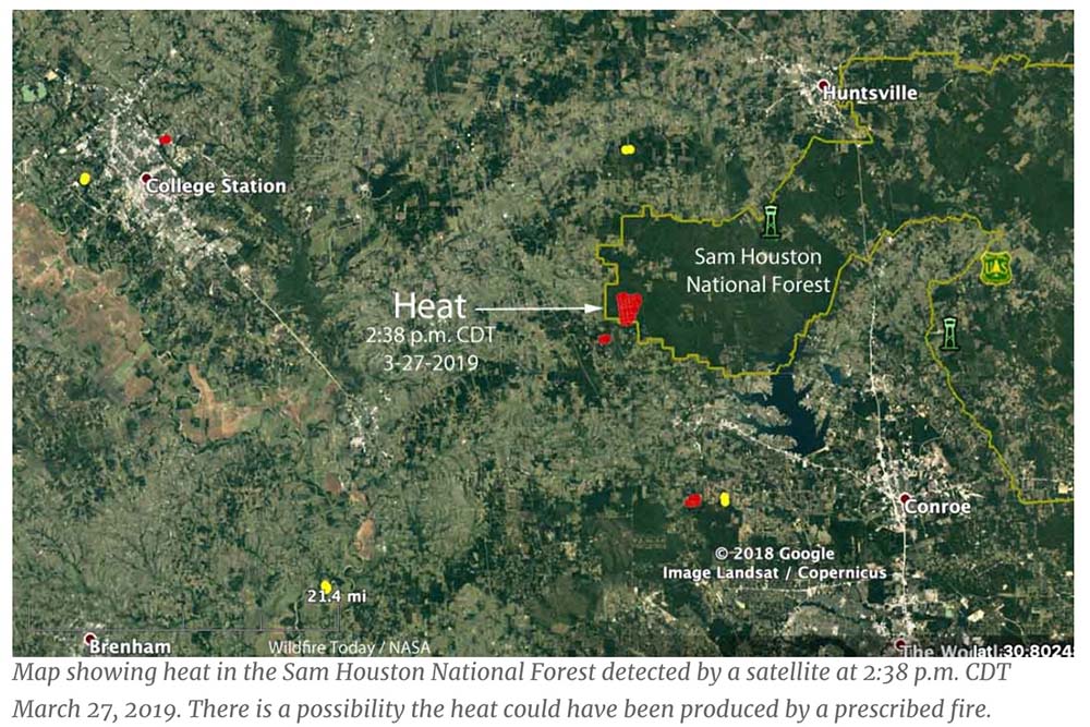
Mr. Laird was a U.S. Forest Service employee who, along with the other firefighter and the pilot, were on an aerial ignition mission on the Sam Houston National Forest. Their equipment was dropping plastic spheres that burst into flame after hitting the ground, helping to ignite the prescribed fire. The ship came to rest outside the active area of the prescribed fire and there was no additional fire caused by the crash.
The pilot and surviving crew member reported that after completing the application of plastic spheres they began flying back to the staging area when the engine lost total power.
The March 27, 2019 helicopter crash in Texas. Photo by Sgt. Erik Burse/Texas Department of Public Safety.
Most NTSB accident reports are fairly straightforward, but this report, due to the way it is written, still leaves a small amount of doubt about the cause of the engine failure. However, signs point toward a loose fuel line.
“The fuel line between the firewall and hydro-mechanical unit (HMU) was loose and the required safety wire was not installed,” it says, and no other discrepancies were found. It does not say if the fuel line was loose enough to cause the engine to lose power.
From the NTSB report:
Federal Aviation Administration inspectors from the Houston Flight Standards District Office interviewed Mountain Air’s Director of Maintenance, who stated that on February 14, 2019, the USFS requested to validate the helicopter’s weight and balance. The helicopter was defueled, which involved disconnecting the main fuel line. After the weight and balance were verified, the main fuel line was reconnected. The director of maintenance asked another mechanic to verify that the fuel lines were reconnected, which was reportedly accomplished. The mechanic that accomplished the work informed the operator that he “was confident” that he torqued and secured the line. There was no other maintenance work which involved opening the fuel line after that day. On February 23, 2019, the helicopter’s engine would not light, and the engine’s igniters and/or igniter box was replaced. A maintenance records review found that the helicopter flew about 24.9 hours after the weight and balance was conducted on February 14, 2019.
On March 25, 2019, the pilot reported to management that the fuel pressure light had “flickered” during a flight “a few days before;” the pilot turned on the fuel boost pump, turned it off, and the light never reappeared. The pilot was informed to monitor the situation and report if it occurred again.
Following the accident, the digital engine control unit (DECU) was removed and sent to the manufacturer for data download. On April 11, 2019, the DECU was downloaded under the auspices of the FAA. The last recorded fault was a “P3 drift or engine flame out.”
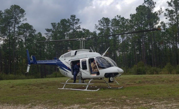
The helicopter, N818MC, was owned Mountain Air Helicopters, Inc. The company has five other helicopters and a Cessna 414A registered with the FAA.
In 2015 two were killed in Mississippi under similar circumstances on a prescribed fire when engine failure brought down a helicopter conducting aerial ignition operations. A third person suffered serious injuries.
The helicopter involved in the March 30, 2015 incident in Mississippi, N50KH, is shown with doors removed and Pilot and PSD operator positions visible.
Our take
Flying low and slow in a single-engine helicopter while igniting fire below the aircraft is obviously very, very dangerous. These three fatalities offer very compelling justification for using drones for aerial ignition instead of manned aircraft.
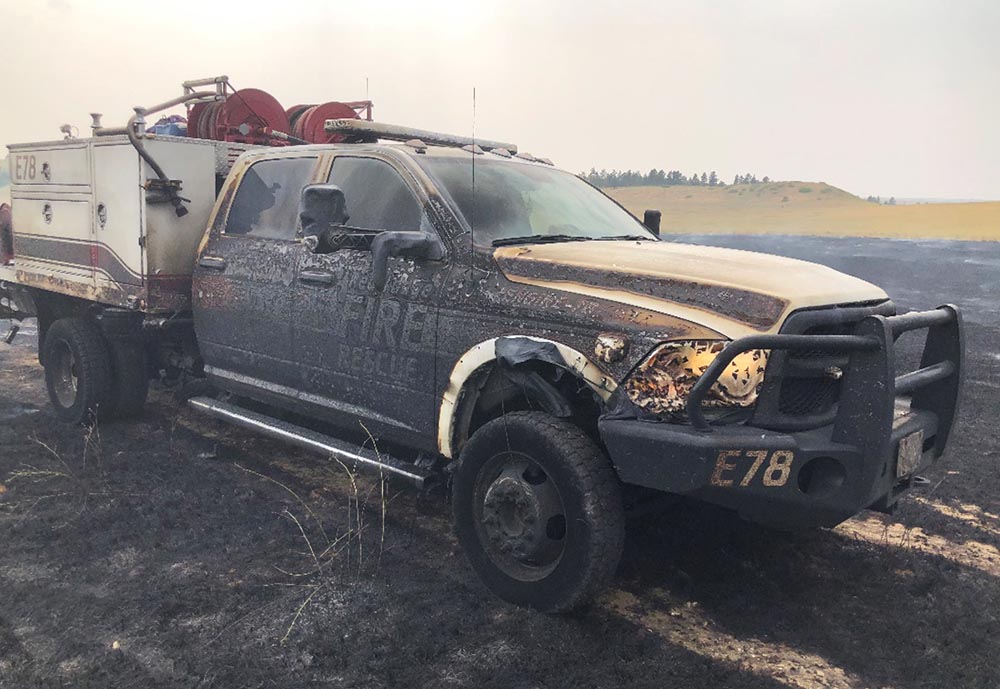
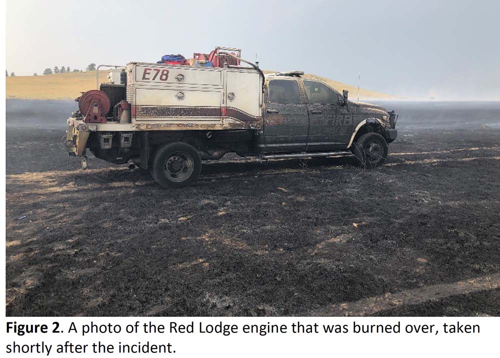
Engine in Harris Fire burnover — July 16, 2021. From the report.
A Facilitated Learning Analysis has been released for the burnover that occurred July 16, 2021 on the Harris Fire near Joliet, Montana 25 miles northeast of Red Lodge. Dan Steffensen of Red Lodge Fire Rescue who had six years of experience with wildland fire was on a two-person engine crew when very strong winds suddenly shifted. He attempted to reach safety, but was overrun by the fast moving fire and was injured. Due to the severity of his burns, 2nd and 3rd degree on 45 percent of his body, Mr. Steffensen was flown to the University of Utah Burn Center in Salt Lake City where he was treated for nine weeks.
Mr. Steffensen was operating a nozzle while he and another firefighter who was driving the engine were making a mobile attack on a grass fire. It was burning in pastureland that had not been burned, grazed, or hayed in six years, consisting primarily of dense grass and some sage approximately two feet in height.
In accordance with department common practice, Mr. Steffensen was not wearing his line pack and fire shelter, as neither he nor the driver would ever get past the end of the hardline hose. In that first section, Mr. Steffensen was always in the driver’s direct line of sight, and the three-to four-foot flames “took down easy” and quickly.
The firefighters did not know that minutes before the burnover the National Weather Service had issued a Significant Weather Advisory for thunderstorms moving in their direction. “Wind gusts of 50 to 60 mph are possible with these storms,” it said. “A gust to 63 mph was reported in Big Timber with this activity.”
When the wind gusts arrived at the fire, increasing from 10 mph to about 55 mph, a helicopter pilot who had been dropping water was forced to jettison the water from his bucket.
As the wind speed suddenly increased and the direction shifted, Mr. Steffensen and the engine were entrapped by flames. The firefighter driving the engine had no visibility and knowing there was a cliff nearby, stayed in place and let it burn over the engine. He later described it as being “hotter than hell in the cab” for the 20-30 seconds of the burnover. He was not injured.
From the report:
For Dan, those few seconds between when he recognized that they had a problem and when the flame front hit were not enough for him to return to the engine or reach the black. He later said “I’ve been on many fires, [and] I’ve never seen one come out of nowhere so fast. All it took was the wind switch.” Although he was only 15 or so feet from the burned portion of the field that he and Scott had just left, the fire was traveling too fast for him to get there. With no line gear on him, and no time to deploy a shelter even if he had carried it, he was left with just his PPE to protect him from the 20-foot high, fast-moving flame front, which hit him after slamming into the driver’s side of the engine and eddying under to the passenger side.
Below are the Key Takeaways from the report:
Almost every single experienced wildland firefighter reading this analysis will find the series of events recounted here familiar: an initial attack in light, flashy fuels with rapidly changing conditions. It can, therefore, be tempting to write this off as an unavoidable situation in an inherently risky profession. While the FLA team agrees that accepting some level of risk while fighting fire is inevitable, we do believe there are some key lessons for the reader to consider, should they ever find themselves in a similar situation.
1) Remember the importance of PPE and wearing it correctly. Dan’s injuries would have been much worse had he not been wearing his Nomex, a layered shirt, gloves, and a helmet in the appropriate manner.
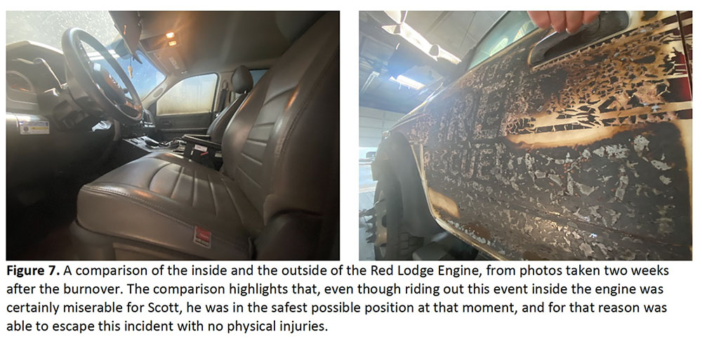
2) Remaining in your vehicle during a burnover may be the best option in light, flashy fuels. Scott was able to walk away from the Harris Fire that day with no physical injuries. The comparison of the conditions inside and outside of E78 suggest that this was the safest place he could have been in that moment.
We also encourage you to reflect on the following questions, especially as they relate to fast-moving initial attack scenarios:
1) When planning your escape route, how much time do you really have to react? It was repeated throughout this analysis, both from individuals involved in the incident and those not involved, how common it is in our current firefighting environment to operate outside of the black. In this case, however, there were some slightly unusual circumstances, such as the high grassy fuel loads, that contributed to the unintended outcome. Take the time to consider such factors, as well as harder to predict factors such as unexpected wind shifts, when planning an escape route.
2) Is the higher level of risk that comes with missing elements of LCES acceptable to you? If yes, what values must be threatened for you to accept that higher level of risk? When asked, Scott shared that his major lesson learned from the day was, “what were we doing here?” With time to reflect, he regretted entering an unburned area with an inadequate escape route to save a few acres of grass, especially when an alternate suppression strategy may have been as effective at keeping the fire on the plateau.
3) What is the process in your organization for quickly communicating special weather statements and advisories about changing conditions? In this case, the special weather statement was issued only minutes before the thunderstorm impacted wind speed, direction, and fire activity at the scene, and no one on the fire received this information in time to react and reevaluate their tactics.
4) When the forecast restates the same thing every day, how do you ensure that you still account for the potential impacts of extreme weather during initial attack? Even if those on the hill had received the special weather statement in a timely manner, it had been hot and dry with a chance of thunderstorms in the area for weeks. Such repetition during fire season often results in the line of thinking that “nothing bad happened yesterday, so today we should be fine again.” Even for the most experienced firefighters, extreme fire weather should still be of note; in fact, these are often the firefighters that must battle most against complacency to objectively consider the potential risk posed by extreme fire weather.
5) Is your assessment of fuels valid? Just as in timber litter fuel types, there can be significant variations in grass fuels with regards to fuel loading and arrangement. In many areas of the west, grazing lands are enrolled in conservation programs that govern the frequency of grazing, haying, or burning, resulting in significantly higher amounts of fuel on the ground. How do you make sure that your assumptions about fire behavior and spread rates are still valid as you make decisions about tactics?
It will use $2.42 billion authorized by the infrastructure bill for fiscal years 2022 through 2026 for fuels-related projects
Geronimo Hotshots on the Big Windy Complex, Oregon, 2013. USFS photo by Lance Cheung.
On Tuesday the U.S. Forest Service announced a 10-year strategy to address what they call the wildfire crisis which poses immediate threats to communities. The initiative, called “Confronting the Wildfire Crisis: A Strategy for Protecting Communities and Improving Resilience in America’s Forests,” combines the recent large investment funded by congress with years of research and planning into a national effort that is intended to significantly increase the scale of forest health treatments over the next decade.
The Forest Service will work with other federal agencies, including the Department of the Interior, and with Tribes, states, local communities, private landowners, and other partners to focus fuels and forest health treatments more strategically and at a larger scale.
Funding was approved in November
The Bipartisan Infrastructure bill signed by the President November 15, 2021 authorized about $2.42 billion for fiscal years 2022 through 2026 for fuels-related projects. (M = million)
$100M, Pre-fire planning, and training personnel for wildland firefighting and vegetation treatments
$20M, Data management for fuels projects and large fires
$100M, Planning & implementing projects under the Collaborative Forest Landscape Restoration Program
$500M, Wildfire defense grants for at risk communities
$500M, Prescribed fires
$500M, Constructing fuelbreaks
$200M, Remove fuels, produce biochar and other innovative wood products
Previous testimony about fuel management before congressional committees
During testimony June 17, 2021 before the Senate Committee on Energy and Natural Resources former US Forest Service Chief Vicki Christiansen said the agency treats fuels on about three million acres each year but said they need to treat two to four times that amount. She repeatedly called for a “paradigm shift” for treating hazardous fuels. Senator Ron Wyden (OR) got Ms. Christiansen to confirm that the agency’s latest estimate is that it would take $20 billion over a 10-year period to “get in front of the hazardous fuel challenge”.
On September 29, 2021 in a hearing before the House of Representatives Agriculture Committee’s Subcommittee on Conservation and Forestry, new USFS Chief Randy Moore said, “We will never hire enough firefighters, we will never buy enough engines or aircraft to fight these fires. We must actively treat forests. That’s what it takes to turn this situation around. We must shift from small scale treatments to strategic science-based treatments across boundaries. It must start with those places most critically at risk. We must treat 20 million acres over 10 years. Done right in the right places, treatments make a difference.”
On October 27, 2021 Jaelith Hall-Rivera, Deputy Forest Service Chief for State and Private Forestry told the House of Representatives’ Subcommittee on Natural Resources, “We need to treat an additional 20 million acres over the next decade and that could cost up to $20 billion or more.”
What is now planned
The plan released Tuesday by the Forest Service calls for:
Treating up to an additional 20 million acres on the National Forest System lands in the West, over and above current treatment levels;
Treating up to an additional 30 million acres on other Federal, State, Tribal, and private lands in the West;
The current level of treatment in recent years has been 2-3 million acres per year for fuels and forest health, the new document stated.
The plan calls for an unprecedented “paradigm shift” in land management to increase fuels and forest health treatments across jurisdictions to match the actual scale of wildfire risk to people, communities, and natural resources, especially in the Western United States.
The Forest Service is developing staffing plans and will be increasing capacity in not only field personnel specializing in prescribed fire to complete the work but also key administrative positions like contracting officers, human resources professionals, collaboration and partnership coordinators, communications, and grants and agreements specialists who will assist in connecting with partners.
During the first two years of the initiative, the agency will be looking for large landscape-scale projects that are ready to go, up until now lacking only the necessary funding.
They will be seeking projects that are:
Designed to reduce wildfire risk to communities, water supplies, or critical infrastructure (including utility lines, roads, and national security sites);
Critical ecological values (including watersheds, wildlife habitat, and old growth stands) and ecosystem services (including carbon storage);
Economic values (including outdoor recreation, timber, and grazing areas);
Areas of cultural and historic significance (including areas important to Tribes); and,
Areas of social importance to communities (including for access and subsistence use).
Reforestation
The new initiative also strives for increased rates of reforestation following forest fires.
“We currently address only 6 percent of post-wildfire replanting needs per year, resulting in a rapidly expanding list of reforestation needs,” the new plan states. “We have plans for the reforestation of more than 1.3 million acres of National Forest System land. However, these plans only address one-third of National Forest System reforestation needs, estimated to be 4 million acres and growing. As we work to recover from wildfire, we are emphasizing planting the right species, in the right place, under the right conditions, so forests will remain healthy and resilient over time.”
Our take
The testimony before congressional committees said that in order to “get in front of the hazardous fuel challenge” and “turn this situation around” the Forest Service needs an additional $2 billion a year for the next 10 years, over and above what is currently being spent. What was appropriated for the next five years was about $0.48 billion per year, less than one-fourth of the additional funds the agency said was needed.
The growth of the climate crisis which has contributed to the “wildfire crisis” appears to be exceeding the estimates of scientists. Changes are occurring even more quickly than previously expected. So low-balling the funding for protecting our homeland will mean we will fall even further behind in treating fuels and attempting to keep fires from wiping out more communities.
The heads of the five federal land management agencies need to be honest with congress and continue to point out the scope of the fuels problem and the increasing risk of fiddling while the forests and subdivisions burn. Congress must accept the facts and pass legislation adequate to address the threats to our ecosystems and communities.