The fire prompted evacuations on the Blackfeet Reservation
Map showing the approximate location of the fire east of Browning, MT. The red dots represent heat detected by satellites at 3 p.m. March 28, 2021.
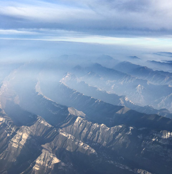
A fire that started about a mile east of Blackfeet Community College burned 25,000 acres between Browning and Meriwether in northern Montana Sunday.
The fire was pushed across farm lands by southwest winds gusting to 54 mph while the relative humidity was in the mid-20s. There is a report that one structure was destroyed.
The Blackfeet Covid-19 Incident Command reported that local fire departments suppressed the fire along with Blackfeet Fire Management and the Chief Mountain Interagency Hot Shots, a crew based in Browning.
Rain that started at about 9 p.m. Sunday followed by snow during the night and temperatures in the low 20s slowed the spread of the blaze.
The Montana DOT camera at Browning, MT showed snow at 2:08 p.m. 3-29-2021.
About this time 10 years ago the Martin Mars, the 747, and two MAFFS air tankers assisted firefighters in Mexico.
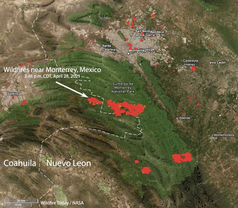
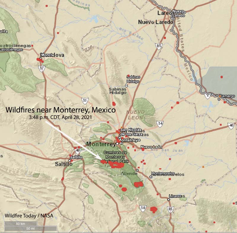
Map showing the location of wildfires (in red) southwest of Monterrey, Mexico 3:48 p.m. CDT March 28, 2021.
One of the DC-10 air tankers, T-912, has started a contract with the state of Coahuila to assist firefighters battling a fire 20 miles southwest of Monterrey in Mexico. Today was its first day of operations but when we spoke to John Gould, President of 10 Tanker at 2:45 p.m. CDT today March 28, the aircraft was on the ground waiting for an improvement in the weather.
They are working and reloading out of the airport in Laredo, Texas about 160 miles northeast of the fire.
The fire they will be dropping retardant on initially is just west of the Coahuila/Nuevo León state line. According to heat detected by satellites it appears to be several thousand acres, while a fire about 4 miles to the east in Nuevo León looks to be more than 22,000 acres. Both fires are near Highway 20.
Wildfires southwest of Monterrey, Mexico 3:48 p.m. CDT March 28, 2021.
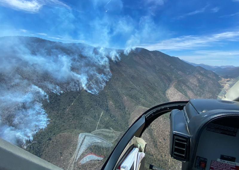
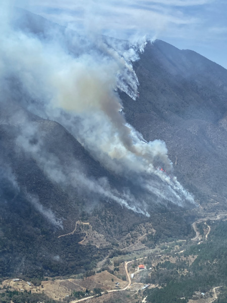
“Beautiful country there,” Mr. Gould told Fire Aviation. “Very steep and challenging country for fighting fire. The state of Coahuila is providing the aerial supervision aircraft and we have put one of our pilots with lead plane and Air Tactical Group Supervisor experience in the right seat.”
Fire SW of Monterrey in Coahuila, Mexico. Noon March 26, 2021. 10 Tanker photo.Fire SW of Monterrey in Coahuila, Mexico. Noon March 26, 2021. 10 Tanker photo.From high altitude, this is the general area of the fires, SW of Monterrey in Coahuila, Mexico. March 27, 2021. 10 Tanker photo.
The Martin Mars was based at Lake Amistad reservoir near Del Rio, Texas. The lake straddles the U.S./Mexico border, and the aircraft was moored on the U.S. side.
National Institute of Justice commits over half a million dollars to improve training and guidelines for wildfire investigations
North Pole Fire, March 10, 2015, South Dakota. Photo by Bill Gabbert.
A skilled wildfire origin and cause investigator can look at burn and char patterns on vegetation and other objects and follow them to the location where the blaze first ignited. If they are lucky, that could lead to the discovery of the cause and other physical evidence which could help track down an arsonist.
Worcester Polytechnic Institute (WPI) researcher Albert Simeoni has been awarded $519,893 from the National Institute of Justice to evaluate the reliability of burn pattern indicators used by investigators to determine the starting point of wildfires.
Albert Simeoni. WPI photo.
Simeoni, professor and head of the Department of Fire Protection Engineering, will use a laboratory wind tunnel at WPI, field studies in a New Jersey forest, and data analysis to determine if scars on a landscape, ash deposits, and other indicators widely used by investigators reliably point to the place where a wildfire originates.
“Investigations are based on burn pattern indicators that have not been scientifically verified, and those investigations have consequences for the people who are impacted by fire, for government agencies, and for companies,” said Simeoni, who is principal investigator of the three-year project. “We want to be sure that investigations are done with the best tools available. We’re not reinventing tools with this study, but we’re looking at the reliability of the tools currently used.”
Wildfires burn millions of acres annually in the United States, causing extensive and costly damage to natural ecosystems, homes, and businesses. Simeoni, a former firefighter, has previously studied how wind impacts wildfires, and he has coordinated training for Greek firefighters combatting wildfires.
Finding the origin of a wildfire can help explain how it started and who might be responsible. Investigators typically examine the shape of burnt grass, the angle of char left behind, craters formed into rocks, marks on buildings, and other physical signs of damage to trace a fire across a landscape and back to its origin point.
Simeoni will study fire indicators in the field in collaboration with firefighters from the New Jersey Forest Fire Service, who manage controlled fires in the New Jersey pine barrens. Simeoni also will conduct studies in a 20-foot wind tunnel at WPI, burning pine needles and other materials under varying conditions such as wind speed, fire intensity, and moisture. Finally, he will compare results from field and lab studies with the results of investigations conducted into fires that burned under similar conditions.
Nicholas Skowronski, a research forester with the U.S. Forest Service, will be co-principal investigator of the project. The project is funded by the National Institute of Justice, which is the research arm of the U.S. Department of Justice.
The project could, Simeoni said, validate existing forensic tools and help fire investigators work more efficiently and with fewer errors. He plans to make the study’s results available to private and public fire investigators.
“Understanding where a wildfire starts can help determine how it started and who, if anyone, may be criminally or financially liable for damages,” Simeoni said. “As a researcher and scientist, I also know that understanding how fires start can help us determine how to prevent, manage, and stop them.”
The findings included insufficient numbers of firefighting resources, and working against the chain of command
Satellite photo showing the fires on Kangaroo Island South Australia, January 6, 2020 local time. NASA.
A report on the 210,000-hectare bushfire that burned almost half of Kangaroo Island southwest of Adelaide, Australia found that there was a shortage of resources, a lack of strategic planning, and cases of not following, or actively working against, the chain of command. The fire killed two people and nearly 60,000 livestock, and destroyed 87 homes.
The 2019-2020 bushfire season in Australia was one for the history books. The 10 million hectares (24.7 million acres) blackened were more than the area burned in the Black Saturday 2009 and Ash Wednesday 1983 bushfires combined.
One of the largest was the Ravine Fire that spread east across the 88-mile long Kangaroo Island off the coast of South Australia, burning 48 percent of the island, more than half a million acres.
The South Australian Country Fire Service (SACFS) commissioned a private company, C3 Resilience, to conduct an independent review of the Ravine Fire to “assist with ongoing operational improvement.” The resulting 95-page report states that it is based on 6,359 observations, 522 surveys, and 63 individual and group sessions.
The SACFS said upon releasing the report, “The men and women of the CFS acted in the best interest of the community despite extremely limited resources and facing circumstances which had never previously been anticipated. Many of these men and women did so at their own risk to their welfare and safety. The report notes many positives and clearly defines the need for better resourcing for the CFS.”
Due to the operational load within the organization, the process of only sending endorsed IMTs [Incident Management Teams] ceased, replaced with an ad-hoc manner of the selection of staff for IMTs including field command positions. This lack of competence resulted in communication deficiencies between the ground, lack of integration of local knowledge. The breakdown at times with communications across the IMT in the planning and operations cells, for example, on the Ravine fire provided a basis for the failure of operational planning occurring at critical times.
The design of doctrine, combined with a lack of capability and competency programs for regional staff along with fatigue led to the RCC [Regional Command Center] being overwhelmed. This led to a lack of strategic resource planning, including using what capability existed within their own region to support operations on KI [Kangaroo Island].
Much of the good work completed was discounted by a culture of some not following, or actively working against, the chain of command. Secondly, there was a lack of accountability by some crews for the mopping up and blacking out procedures led to further fire spread. The lack of technology gave the IMT little intelligence picture to work to in collecting the achievement of tactics where successful, and detecting issues of lack of accountability where they occurred.
The SACFS [South Australian Country Fire Service] has a lessons management system, however it failed implementation for the KI fires, as the lessons have not translated into planning across coordinated fire fighting agencies.
The fires on KI needed every capability they could get. The insertion of the ADF [Australian Defense Force] was a welcome one, however the tasking process took some time to adjust to and work through. The integration of the forestry industry was mixed between fully integrated and not at all.
There is significant opportunity to achieve good community outcomes by further integrating FFUs [Farm Firefighting Units] into operations of fires across KI. By all parties agreeing on a coordination model, and common standards of PPE [personal protective equipment], safety standards and how to communicate, it will only increase positive outcomes for the community.
Aviation responded well to support ground crew efforts. The establishment of a TRZ [Temporary Response Zone] could have assisted with a more rapid deployment to the Ravine Complex. An even closer relationship between IMT and aviation specialists will increase the outcome for fires on KI to integrate air and ground tactics.
Satellite photo from January 3, 2020 local time showing the Ravine Fire on Kangaroo Island in South Australia. The red dots represent heat. Later the wind shifted, blowing the smoke toward the northeast. NASA.
The fire caused four fatalities and burned more than 56,000 acres in Northern California last year
Zogg Fire, Sept. 27, 2020. CAL FIRE photo.
CAL FIRE has determined that last year’s Zogg Fire was caused by a pine tree contacting power lines owned and operated by Pacific Gas and Electric (PG&E) in Northern California.
The fire started in Shasta County near the community of Igo September 27, 2020 and burned 56,338 acres, destroyed 204 structures, and caused four civilian fatalities.
The Zogg Fire investigative report has been forwarded to the Shasta County District Attorney’s Office.
The fire spread quickly as strong winds out of the north-northeast pushed the fire toward Highway 36 where firefighters were able to stop it before it crossed the road. The blaze was burning while many other fires were being fought by thousands of firefighters in California and Oregon, causing resources to be stretched thin.
“The loss of life and devastation in the communities impacted by the Zogg Fire is tragic, and we recognize that nothing can heal the hearts of those who have lost so much,” PG&E said in a statement. “We also thank the courageous first responders who saved lives, protected property and worked to contain and put out the fire.”
From the Sacramento Bee:
The determination [of the cause of the fire] came as no surprise, as investigators zeroed in on PG&E as the fire was being fought. Investigators at the time seized PG&E’s power equipment, and the company disclosed in October that damages from the Zogg Fire could exceed $275 million.
Those costs would come on top of the $625 million in potential claims from the 2019 Kincade Fire, which investigators say was caused by a faulty PG&E transmission line. Separately, PG&E agreed to pay $13.5 billion to cover uninsured losses from the 2018 Camp Fire and the 2017 wine country fires.
The horrific fires of 2017 and 2018 drove PG&E into bankruptcy. It emerged from reorganization last summer after pledging to Gov. Gavin Newsom that it was overhauling its operations and leadership to put a greater emphasis on wildfire safety.
PG&E pleaded guilty to 84 counts of involuntary manslaughter on June 16, 2020 for the 84 people that were killed during the Camp Fire that devastated Paradise, California November 8, 2018. The fire burned 154,000 acres and destroyed more than 18,000 structures.
In the current pandemic, in-person training is challenging for fire departments. With support from the Assistance to Firefighters Grant Program, New York University collaborated with several fire departments to develop a web-based, interactive firefighter training program – ALIVE (Advanced Learning through Integrated Visual Environments). The system simulates critical decision-making aspects of firefighting and reinforces safety concepts developed by leading industry researchers though interactive tactical scenarios.
This interactive training is now free for Firefighters.
In addition to modules for Fire Dynamics, Residential Fires, Fires in Lightweight Residential Construction, and Wind-driven High-Rise Fires, there are also modules for Wildland fires, including:
Wildland Fire Behavior and Size-up,
Wildland Incident Action Plan and Operational Briefing,
Wildland Fire Scenarios, and
Wildland Urban Interface Structure Defense.
You can either take the courses online from a computer, or the modules can be downloaded individually onto a smart phone or tablet.
Firefighters can access the training at: http://fire.engineering.nyu.edu/ . The page has links to download the modules onto a smart phone, which can also be found on Google Play and the Apple App Store by searching for, Alive: wildland.
Fire departments interested in offering ALIVE training to their members can register by emailing the NYU Fire Research Group at fire.research@nyu.edu. More information is available at http://fire.engineering.nyu.edu/