Anyone got a spare helicopter?

Cuesta Colorada Ixmiquilpan Hidalgo — At least six active wildfires are burning in Hidalgo, according to a report by La Silla Rota, fires that have affected hundreds of hectares and also the civilian population, including the fire that started in Nicolás Flores and has spread to Cuesta Colorada, Ixmiquilpan.

From the plenary session of the local Congress, deputy Osiris Leines Medécido made a call to support fire victims.

Fires just north of Mexico City have evacuated residents and threatened towns.

Mexico fires -- Cuesta Colorada Ixmiquilpan Hidalgo north of Mexico City.
Mexico fires — Cuesta Colorada Ixmiquilpan Hidalgo north of Mexico City.

Osiris Leines Medécido talked about the fires in Hidalgo territory, and he emphasized the one that started in Nicolás Flores and has spread to  Ixmiquilpan.

Fires in the community called Cuesta Colorada Ixmiquilpan Hidalgo

“In Cuesta Colorada, people have organized themselves to be able to fight this fire, the entire population, the delegates, those who represent spas and citizens have all organized, but the intervention of the authorities at the different levels of government is required; the situation requires professionals in the subject, with the appropriate tools and instruments,” he said.

Smoke just north of Ciudad de México, photo ©2024 Brian Okarski

Osiris Leines extended the request of his colleague Aarón Charrez Paloma,  substitute local deputy for the District of Ixmiquilpan, to provide support for the people affected by this fire in the Mezquital Valley.

CuestaColorado Ixmiquilpan Hidalgo
facebook post about fires at Cuesta
Colorado Ixmiquilpan Hidalgo

The Associated Press reported that wildfires were burning in nearly half of Mexico’s drought-stricken states yesterday, fueled by strong winds; the National Forestry Commission reported 58 active fires in 15 states, including in protected nature reserves in Morelos, Veracruz, and Mexico states.

Strong winds and high temps have blocked the efforts of local volunteers to fight the fire

Mexico News Daily reported earlier this month that five residents of the town of San Lucas Quiaviní died while trying to fight a forest fire that threatened their village in the eastern section of the Central Valleys region of the state of Oaxaca, some 40 kilometers from the state capital of Oaxaca City. Villagers had tried to contain the fire but it quickly spread and the five men were overwhelmed by the fire.

In front of my father's house
“In front of my father’s house” Tuesday afternoon

State authorities were alerted as soon as the fire was spotted, but villagers say officials were slow to react.

The Oaxaca state government did not issue an emergency assistance plan until after the fatalities were reported, two days after they were alerted to the fire. By then, San Lucas Quiaviní had issued a call to neighboring municipalities to help combat the blaze.

Mexico and U.S. working together on wildfire

This year the U.S. and Mexico celebrated their 200th year of diplomatic relations, and for almost 25 years now the two countries have worked together in information-sharing and wildfire management. The U.S. Forest Service and the National Forest Commission of Mexico (Comisión Nacional Forestal, or CONAFOR) work with similar wildland fire challenges and a shared approach in the Incident Command System.

CONAFORThis collaboration has its roots back in 1998, when Mexico suffered through its worst fire season on record and was mounting a massive response to try to contain environmental damage and community threat. According to a recent feature story by the Forest Service’s International Programs, smoke from the 1998 Mexico fires caused serious air quality deterioration across hundreds of miles from Veracruz north to the Gulf States along the U.S. border.
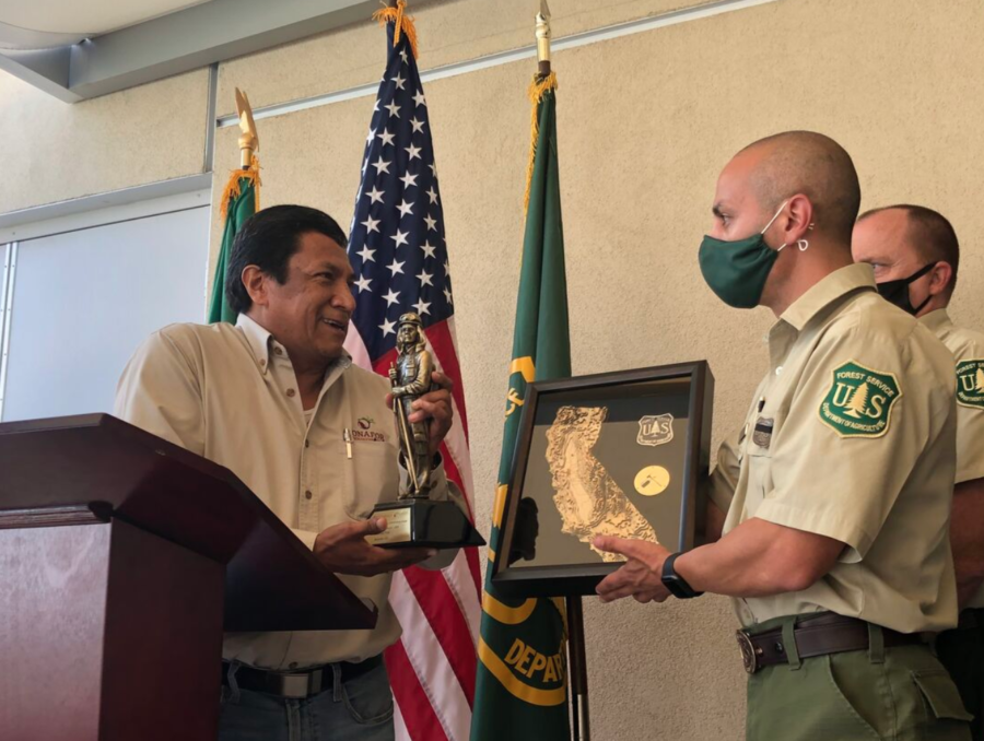
The USFS sent literally tons of equipment, personnel, and other resources to Mexico, initiating what’s become a longstanding knowledge-sharing exchange. U.S. firefighters began then to regularly travel to Mexico to teach ICS principles and operations and to share resources, and Mexican firefighters started traveling here to help fight fires and add skills alongside U.S. firefighters.

Eduardo Cruz with USFS fire people
Eduardo Cruz with USFS Region 5 fire people
photo courtesy CONAFOR

Eduardo Cruz traveled from Mexico to the Sequoia National Forest soon after the 1998 fires. He worked on a helitack crew in California and launched longtime international friendships; Cruz is now the fire management director of CONAFOR. During 2020’s brutal R5 season, he brought five crews of Mexican firefighters to California to work on fires — the first time that Mexico had sent an entire delegation of firefighters to support U.S. efforts.

CNN reported back in September 2020 that the Mexican crews brought to California by Eduardo Cruz worked on the Sequoia Complex, which at the time had burned more than 144,000 acres and was just 35 percent contained. “Fires do not have borders, fires do not have different languages and cultures,” Cruz told CNN. “In the end we all speak the same language when it comes to fighting fire.”

The Forest Service has a 2020 photo album online [HERE].

An archived story from WILDLAND FIREFIGHTER Magazine about the 1998 fires in Mexico is online [HERE]. (NOTE that it’s on the archive.org website and most of the old links on that page are no longer functional.)

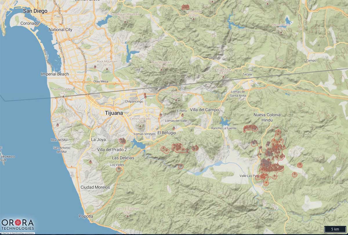
Map of wildfires in northwest Mexico

(UPDATED at 3:28 p.m. PDT June 12, 2020)

The map below shows heat on fires detected by satellites over the last two days only, and does not include the previous five days like the map farther down.

Fires northwest Mexico
Heat detected on fires in northwest Mexico during the 48-hour period ending at 3:20 p.m. PDT June 12, 2020.


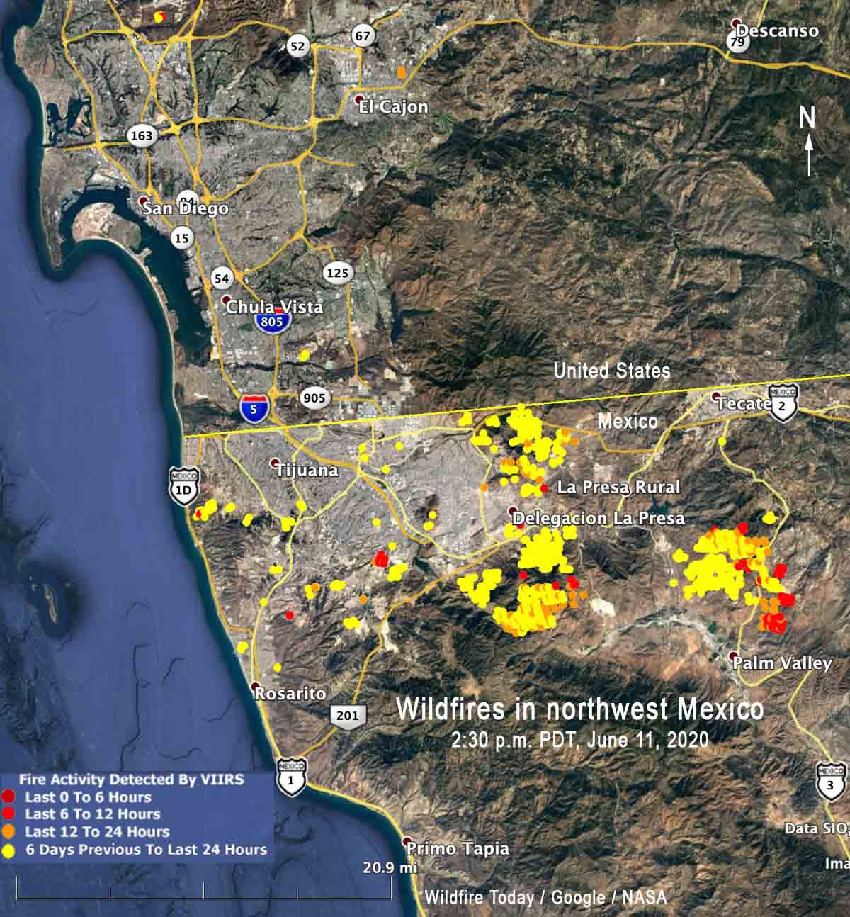
(Originally published at 2:43 p.m. PDT June 11, 2020)

wildfires in northwest Mexico fires
Map showing the location of heat from fires in northwest Mexico detected by a satellite, updated at 2:30 p.m. PDT June 11, 2020.

The smoke map we posted earlier today showed a great deal of smoke being created in northwest Mexico. Here is a map with the locations of those fires.