Strong winds push Kincade Fire west across Highway 128

The mandatory evacuation zones stretches to the Pacific Ocean

Above: The Kincade Fire as seen from the St. Helena North camera at 9:06 a.m. PDT Oct. 27, 2019. Looking toward Healdsburg.

UPDATED at 5:53 p.m. PDT October 27, 2019
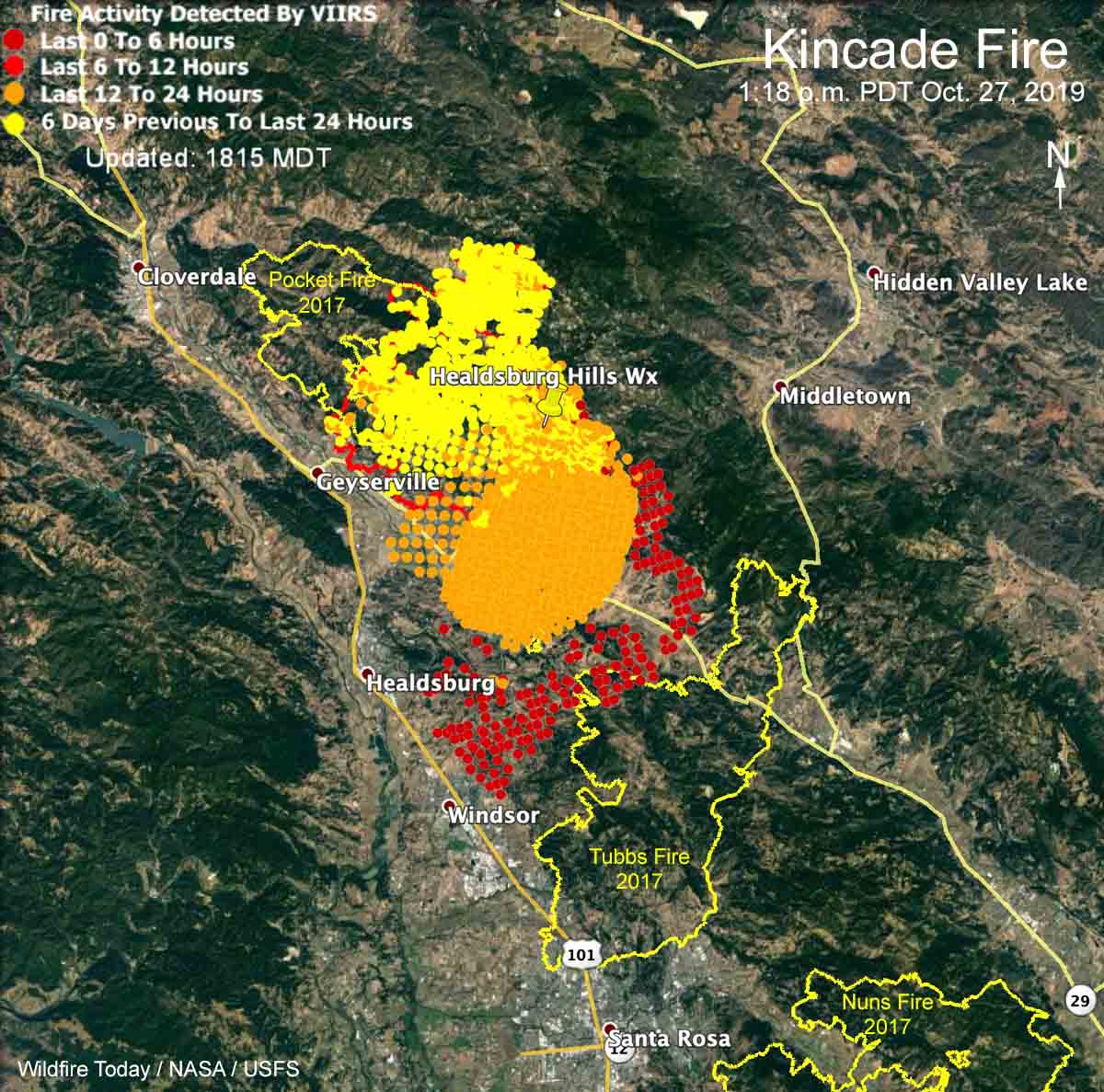
Map Kincade Fire 1:18 p.m. PDT October 27, 2019
Map showing heat detected on the Kincade Fire by a satellite as late as at 1:18 p.m. PDT October 27, 2019. Not to be used for planning or evacuation decisions.

UPDATED at 12:30 p.m. PDT October 27, 2019

At a 10 a.m. press conference fire officials said they hope to stop the 30,000-acre Kincade Fire at the 101 freeway. The area west of the 101 does not have a recent history of fires so the vegetation, or fuel, is heavy and would present even more resistance to control.

After being closed and then open, the 101 is being closed again in the Healdsburg area between Arata Lane and Dry Creek.

Air attack, orbiting overhead and directing aircraft traffic on the Kincade Fire, has ordered large air tankers, hoping  that they can be effective in spite of the near hurricane-force winds creating turbulence and possibly blowing retardant off target.
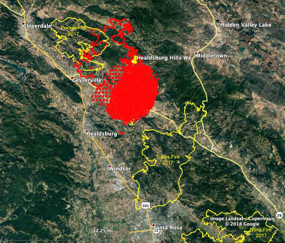
map perimeter of the Kincade Fire
On the map of the Kincade Fire the red dots (or, the large red area) represent heat detected by a satellite at 3:36 a.m. October 27; those locations are not confirmed by personnel on the ground. The red line was the perimeter at 1:36 a.m. October 27, 2019 as detected by a fixed wing aircraft. Shown also are two large burn areas from 2017. The map should not be used for planning or evacuation decisions.

 UPDATED at 9:30 a.m. October 27, 2019

Strong winds out of the northeast pushed the Kincade Fire across Highway 128 at about 3 a.m. on Sunday. A gust of 93 mph was recorded at the Healdsburg Hills North weather station at 5:50 a.m. PDT. Ten other weather stations in the area showed gusts at 50 mph or above.

map perimeter of the Kincade Fire
On the map of the Kincade Fire the red dots (or, the large red area) represent heat detected by a satellite at 3:36 a.m. October 27; those locations are not confirmed by personnel on the ground. The red line was the perimeter at 1:36 a.m. October 27, 2019 as detected by a fixed wing aircraft. The map should not be used for planning or evacuation decisions.

Air tankers are not able to assist firefighters on the ground Sunday morning due to severe wind turbulence making it unsafe to fly and difficult for retardant to accurately hit targets.

Early Sunday morning the fire was about 10 miles north of Santa Rosa, California.

The fixed wing mapping flight at 1:36 a.m. Sunday found that the fire had burned 29,101 acres, but much additional growth has occurred since then.

(To see all articles on Wildfire Today about the Kincade Fire, including the most recent, click here.)

The fire was moving to the southwest in the general direction of Healdsburg and Windsor. Reporters and photographers on the scene are saying structures, including the Soda Rock Winery, have burned near Highway 128.

For several hours overnight Highway 101 was closed between Santa Rosa and Cloverdale but began to reopen at about 6:50 a.m. Sunday.

Mandatory evacuation zones stretch all the way west to the Pacific Ocean affecting 180,000 people. Sonoma County maintains current evacuation information, including a zoomable map.
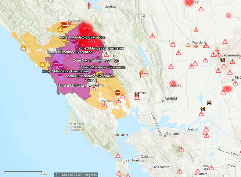
Evacuation zones Kincade Fire
Evacuation zones. Map by Sonoma County. Check HERE for the most current data.

We will update this article as more information becomes available.

Smoke forecast and Red Flag Warnings for Sunday Oct. 27

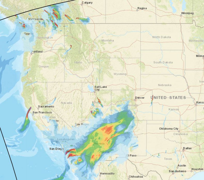
Smoke will affect areas in Arizona, New Mexico, and southern California

smoke forecast October 27, 2019
Forecast for vertically integrated (high level) smoke at 5 p.m. PDT October 27, 2019.

On Sunday October 27 smoke from wildfires in northwest Mexico will affect areas in southern California, Arizona, and New Mexico.

smoke forecast October 27, 2019
Forecast for near surface (low level) smoke at 5 p.m. PDT October 27, 2019.
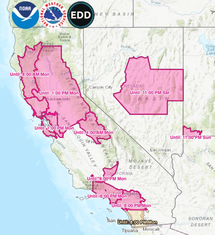
Red Flag Warnings
Red Flag Warnings as of 7 p.m. PDT October 26, 2019. Times are CDT.

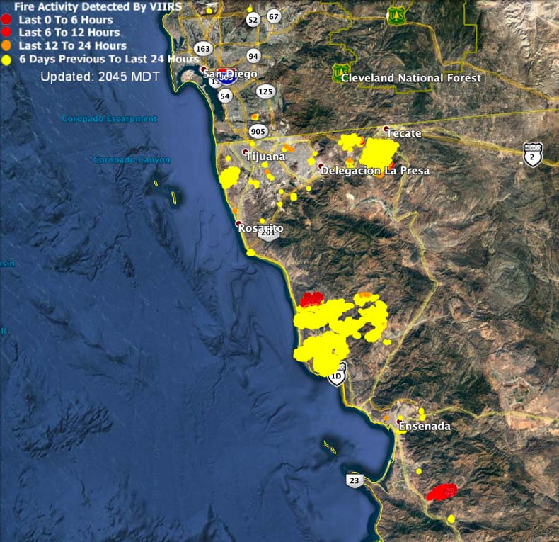
The smoke in Mexico has been coming from the fires shown on the map below.

fires wildfires northwest Mexico
Map showing heat detected on wildfires in northwest Mexico as last as 1:36 p.m. PDT October 26, 2019.

Additional evacuations ordered for Kincade Fire

While rescuing two civilians a firefighter used a fire shelter as a shield

Above: Looking east at 4:40 p.m. October 25 the camera at Geyser Peak photographed a large flare up on the Kincade Fire.

UPDATED at 7:37 p.m. PDT October 26, 2019

New evacuation orders and warnings have been issued for the Kincade Fire. Details are at the Sonoma County web site. Winds gusting to over 60 mph hour are in the forecast for the Kincade Fire area after 11 p.m. Saturday. This is a very serious situation and anyone in the identified areas needs to leave.

One of the more active areas on the fire Saturday was on the east side near Pine Flat Road, the same general location as the flareup Friday.

Saturday afternoon officials said 31 homes and 46 other structures have been destroyed.

Four Very Large Air Tankers were working the Kincade Fire Saturday afternoon preparing for the very strong wind later tonight: Tankers 910, 911, 914, and 944 — three DC-10s and the 747. Several other air tankers and helicopters were also engaged.

Below is the National Weather Service forecast for wind in the Kincade Fire area. The wind barbs point to the direction the wind will be from, in this case, after 7 p.m. north-northeast or northeast through Monday morning. The upper line represents wind gusts.

Wind Forecast Kincade Fire
Wind forecast, Kincade Fire Area, beginning Saturday October 26. Click to enlarge.

7:45 a.m. PDT October 26, 2019

Friday afternoon the Kincade Fire east of Geyserville, California consumed about 4,000 more acres as winds that shifted 180 degrees, twice, pushed it in various directions. At the Healdsburg Hills North weather station the wind in the morning was from the north until 11 a.m. when it became out of the south at 7 to 15 mph gusting at 10 to 24 mph. Then between 5 and 6:30 p.m. it made a slow direction change to north at 12 to 15 gusting at 15 to 26. This resulted in the fire spreading on the north and east sides. As of Saturday morning it has burned 25,455 acres.

(To see all articles on Wildfire Today about the Kincade Fire, including the most recent, click here.)

New evacuation orders were issued overnight. The map maintained by the Sonoma County Sheriff’s office can be accessed here.

CAL FIRE confirmed that a firefighter and two civilians were transported to a hospital by ground ambulance to be evaluated after an incident within the incident. At approximately 6:20 p.m. Friday a firefighter was helping get two civilians to safety who were attempting to evacuate as the fire activity intensified. The firefighter deployed his fire shelter to shield them from the fire. All injuries appear to be non-life threatening.

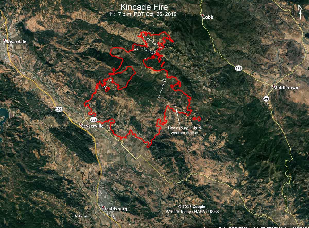
Map Kincade Fire
Map of the Kincade Fire showing the perimeter at 11:17 p.m. October 25, 2019.

The light wind predicted for Saturday is not expected to be a major factor on the fire, but beginning at 11 p.m. it will increase through the rest of the night to 33 mph gusting out of the northeast at 60. It should decrease on Sunday afternoon to 17 mph with gusts around 30.

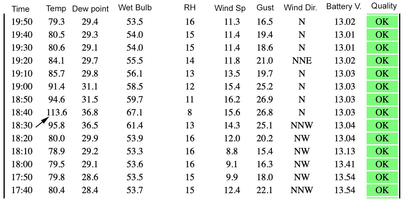
The Healdsburg Hills North weather station is operated by Pacific Gas and Electric and judging from the coordinates appears to be mounted on a high voltage transmission tower. That location on the east side of the fire (see map) was burned over Friday afternoon between 6:20 and 6:30 p.m. Within a 20-minute period the recorded temperature increased from 80 to 114 degrees, then by 7:30 p.m. it was back to 80 degrees.

Weather observations Kincade Fire
Weather observations at the Healdsburg Hills North weather station October 25, 2018 as the site was burned over by the Kincade Fire.

CAL FIRE reports that 79 structures have been destroyed.

Resources assigned to the Kincade Fire include 53 hand crews, 179 engines, 24 water tenders, 24 dozers, and 10 helicopters for a total of 2,090 personnel.

Firefighters assist disabled woman at Tick Fire

firefighters assist disabled woman Tick Fire California

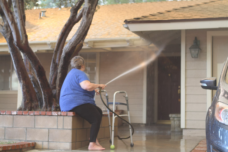
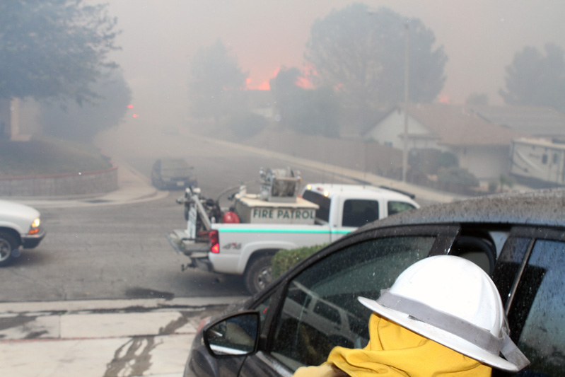
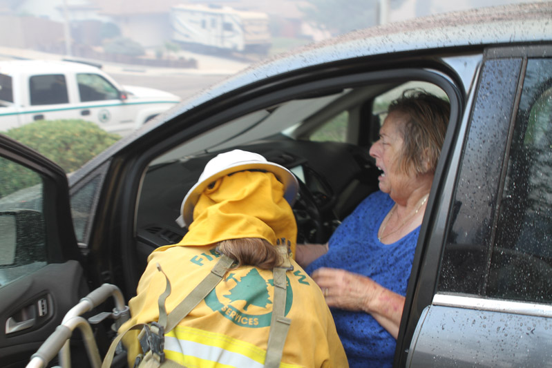
Long time fire photographer Jeff Zimmerman sent us these photos he shot Thursday at the Tick Fire near Santa Clarita in southern California.

Here is his description:

“As flames swept out of Tick Canyon into the Shadow Pines neighborhood in Los Angeles County, it became a race against time to evacuate a disabled woman who was trying to save her home. Barefoot and with a walker, we found this woman frantically trying to save her home with a garden hose. We pulled out our booster line from our volunteer fire patrol to stop spot fires on neighboring property as ash and soot were raining down on her vehicle. We had just minutes to get her shoes, her dog and get her loaded into her vehicle. She was crying hysterically but we were able to get her to safety as fire swept down the street.

“At great personal risk Volunteer Denise Shippy went inside her home to retrieve car keys, shoes and the family dog as I was able to hold back spot fires. Flames erupted across the street in Italian Cypress trees as this woman left to safety. Helping a neighbor in distress is what volunteering is all about.”

firefighters assist disabled woman Tick Fire California firefighters assist disabled woman Tick Fire California firefighters assist disabled woman Tick Fire California

Three large fires are very active in Mexico

The fires are south and southeast of San Diego, California

fires in northwest Mexico ,a[
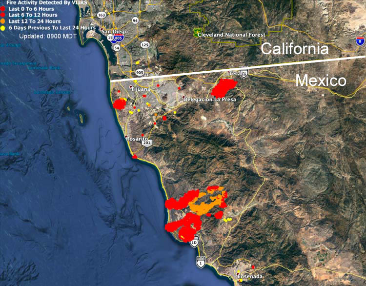
Map showing heat from fires in northwest Mexico detected by a satellite at 4:24 a.m. PDT Oct. 25, 2019.
Several large fires in northwest Mexico south of San Diego are producing large quantities of smoke. For the time being most of it is being blown over the Pacific Ocean.

One of the fires is west of Tijuana, another is northwest of Ensenada, and the third is south of Tecate.

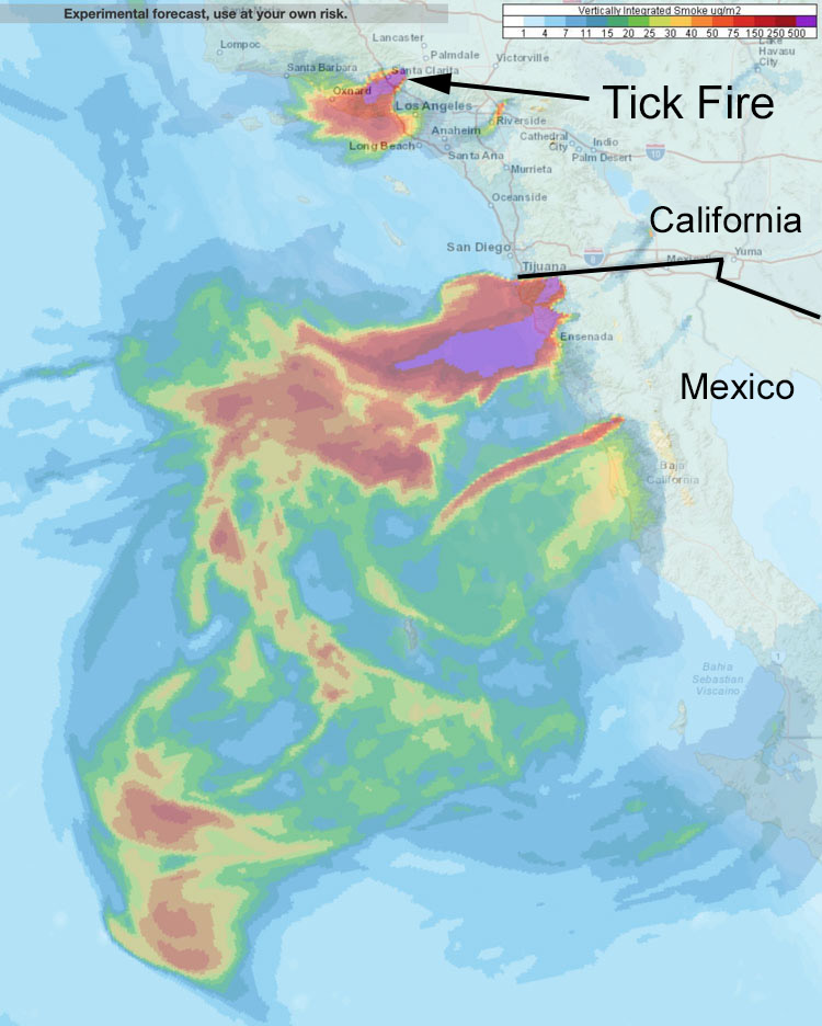
Smoke from the Tick Fire at Santa Clarita is expected to affect Oxnard and western Los Angeles.

smoke wildfire southern California and northwest Mexico.
Forecast for vertically integrated smoke at 5 p.m. PDT Oct. 25, 2019 from wildfires in southern California and northwest Mexico.

Smoke predicted to affect San Francisco Bay area

Possibly the strongest wind event of the fall season will occur in northern California Saturday morning into Monday

forecast 4 a.m. PDT October 26 fire wildfire smoke
Forecast for the distribution of near surface smoke at 4 a.m. PDT October 26, in the San Francisco area and south as far as Santa Barbara. Click to enlarge.

UPDATED at 6:09 p.m. PDT October 25, 2019

The map above is the forecast for the distribution of near surface smoke at 4 a.m. PDT October 26, in the San Francisco area and south as far as Santa Barbara.


7:56 a.m. PDT October 25, 2019

northern california San Francisco Forecast near surface smoke western united states
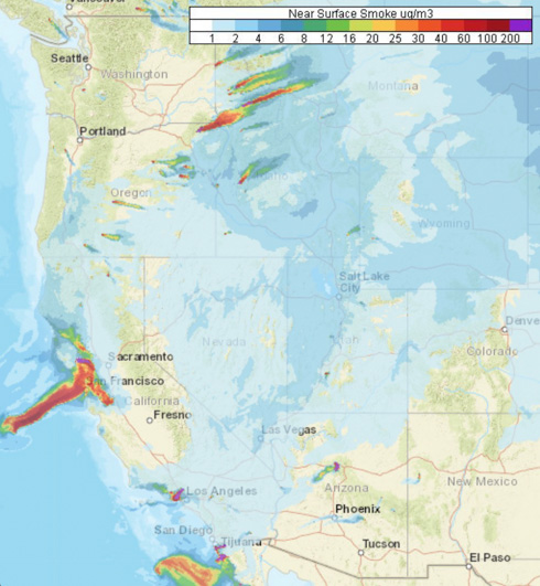
Forecast for near surface smoke in the western U.S. at 5 p.m. PDT Oct. 25, 2019

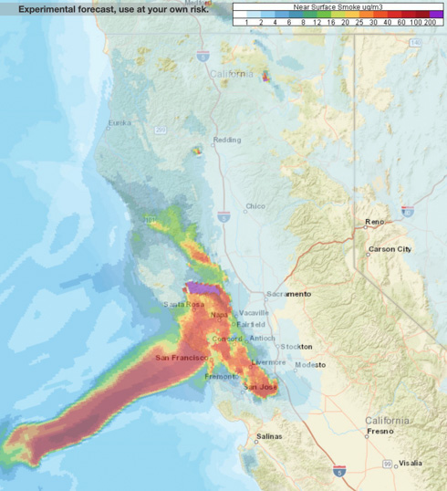
Forecasters predict that smoke from the Kincade and Tick Fires will heavily affect some locations in northern and southern California Friday. Especially affected will be the San Francisco Bay Area, from San Jose north to Santa Rosa, including the city of San Francisco.

Smoke from prescribed burning will be noticed by residents in Oregon, Idaho, and Montana.

northern california San Francisco Forecast near surface smoke northern California
Forecast for near surface smoke in northern California at 5 p.m. PDT Oct. 25, 2019

Red  Flag Warnings will continue in Southern California until Friday night.

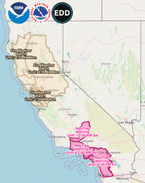
Red Flag Warnings Fire Weather Watches
Red Flag Warnings and Fire Weather Watches, at 7 a.m. PDT Oct. 25, 2019. Times are CDT.

Very strong, dry winds are in the forecast for northern California beginning Saturday morning. This wind event which will continue into Monday is being described as “likely the strongest wind storm of the fall season” with northeast to east winds of 30 to 40 mph gusting at 45 to 70. The Watch areas in the map above will probably be upgraded to Red Flag Warnings by late Friday or Saturday morning.

(Red Flag Warnings can be modified throughout the day as NWS offices around the country update and revise their weather forecasts.)