President renews his attack on California and “forrest” management

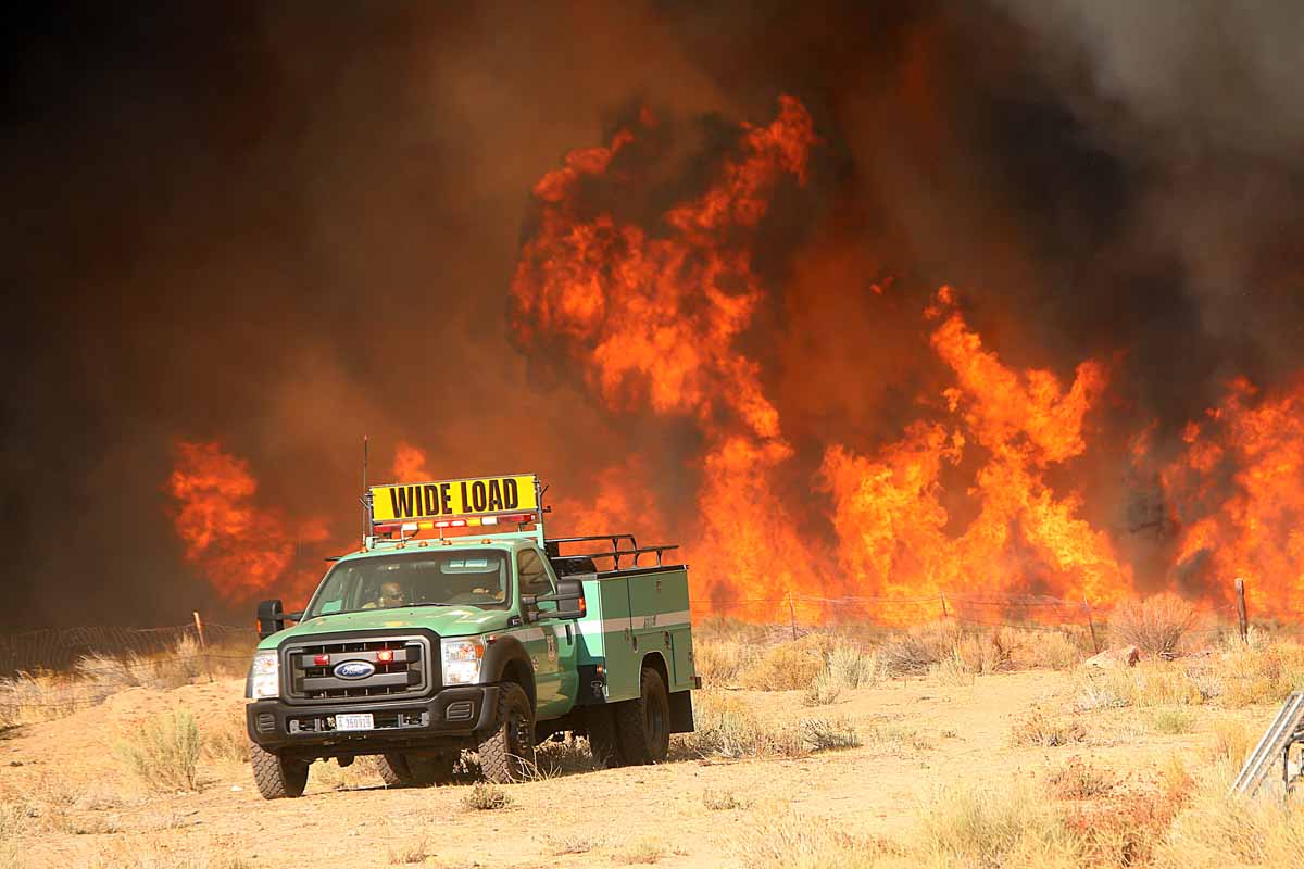
Pilot Fire
A dozer tender on the Pilot Fire in Southern California, August 7, 2016. Jeff Zimmerman photo.

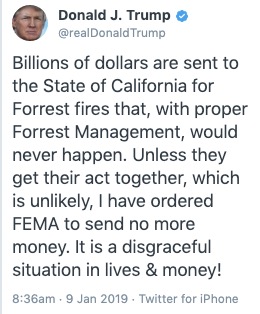
This morning when I saw a tweet that appeared to be from President Trump that threatened to “send no more money” to California at first I thought it was sent by a parody account. The fact that “Forrest” was misspelled, not once but twice, and capitalized, made it seem unlikely that the leader of the free world could misspell the word. Then I saw the little blue checkmark, indicating that it is a verified account.

I made a screengrab of the tweet in case it was deleted, and shortly after that, it was. Here is the original version:
Trump President forrest
Tweet by President Trump which was deleted Jan. 9, 2019.

About 50 minutes after sending the Forrest tweet he deleted the first version and sent a revised copy that was exactly the same, but this time spelling “Forest fires” correctly.

If our President is going to try to influence how state or federal land management agencies manage their forests, he needs to know enough about the issue to spell the word correctly.

Mr. Trump has made the threat of cutting off funds to California related to wildfires on other occasions, including November 10, 2018 and October 17, 2018.

On November 27 Mr. Trump expanded on his wildfire management opinions in a lengthy interview with two reporters from the Washington Post, Philip Rucker and Josh Dawsey. Below is a portion of what he said to them about fires, according to the Post:

I was watching the firemen and they’re raking brush — you know the tumbleweed and brush and all this stuff that’s growing underneath. It’s on fire and they’re raking it working so hard, and they’re raking all this stuff. If that was raked in the beginning, there’d be nothing to catch on fire.

It sounds like the firefighters were mopping up, using tools to stir duff and burning materials so that it can cool, or so water can be more efficiently applied. He also has advocated raking the forest floors. But reducing the threat of wildfires is much more complicated than raking. On December 28, 2018 I wrote about some of the complexities involved in preventing homes from burning during a wildfire, and the fact that home owners, planners, and local jurisdictions have the responsibility to design structures, infrastructure, and communities that can live with wildfires. Treating fuels near residential areas using mechanical methods or prescribed burning is also necessary. More logging is not the answer.

According to a 2015 report by the Congressional Research Service the federal government manages 46 percent of the land in California. The California Department of Forestry and Fire Protection manages or has fire protection responsibility for about 30 percent.

In August the President tweeted about California,“Must also tree clear to stop fire spreading!”

Below is an excerpt from an article in the Sacramento Bee on August 7, 2018:

The Trump administration’s own budget request for the current fiscal year and the coming one proposed slashing tens of millions of dollars from the Department of Interior and U.S. Forest Service budgets dedicated to the kind of tree clearing and other forest management work experts say is needed. And it’s just one example of how the federal government is still not prioritizing fire mitigation to the scale that is needed, according to forestry experts.

“I think for a number of years the feds were more ahead of this dilemma, at least in discussions,” said Scott Stephens, a professor of fire science at the University of California, Berkeley. But “I have to say right now, I think the state is moving ahead. It’s certainly being more innovative, it’s doing more policy work.”

Firefighters from NSW assist with Tasmania bushfire

Gell River Fire Tasmania
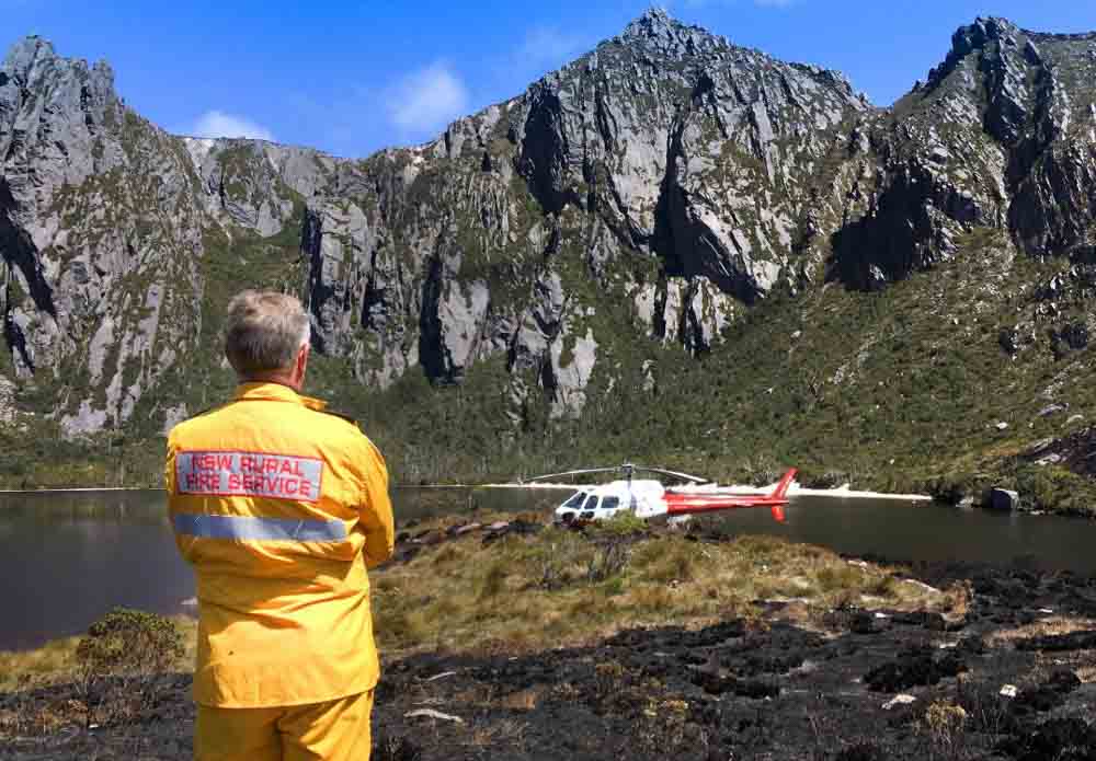
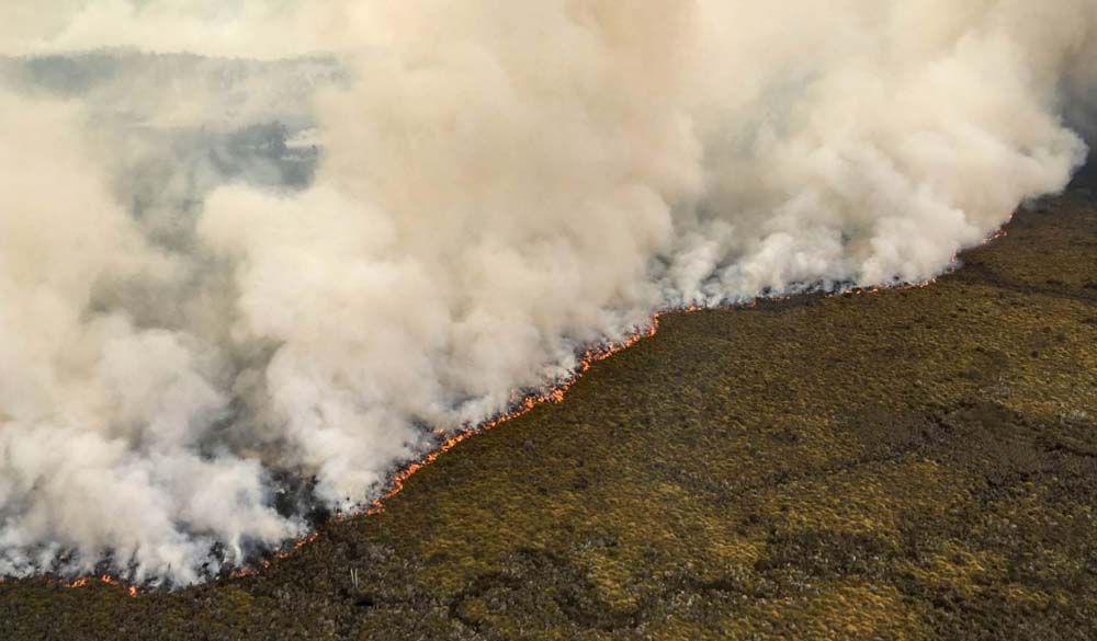
Gell River Fire. Photo by Andrew MacDonald

Firefighters in New South Wales have traveled across the Bass Strait to assist their brothers and sisters in Tasmania. The five personnel will be working with the Tasmania Fire Service, specifically on the Gell River Fire in the southwest part of the state. The deployment of five arrived Sunday to assume specialist aviation roles operating out of Hobart and Strathgordon.

Map Gell River Fire in Tasmania, Australia
Map showing the location of the Gell River Fire in Tasmania, Australia.

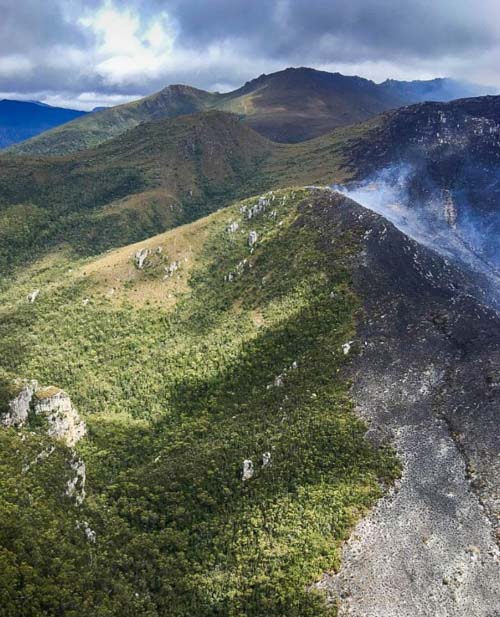
The Gell River Fire has burned 50,600 acres (20,500 ha) primarily in Franklin-Gordon Wild Rivers National Park. Portions of the fire are burning in peat, which means the deep-seated blaze will likely persist for months and continue to produce smoke.

Below is an update on the fire from the Tasmania Fire Service:

The fire continues to burn in buttongrass and mixed forest vegetation in the Vale of Rasselas, approximately 10 kilometres northwest of Tim Shea and along the Denison Range and Gordon Range. A sprinkler line around the northern side of Lake Rhona was successful in protecting fire-sensitive vegetation communities. Fire fighters and aerial water-bombing also managed to protect these vegetation communities in other areas. Specialist remote area fire fighters are working in rugged terrain to extinguish the fire. Although the fire is still uncontained, suppression operations conducted by fire fighters and water bombing aircraft have been successful to date, with many active fire edges minimised. An increase in smoke may be visible in the Greater Hobart area, Derwent Valley and Huon Valley on Tuesday evening and Wednesday due to increased fire activity, particularly at the southern end of the fire. Resources currently deployed to the Gell River bushfire include 60 personnel and eight aircraft. Tasmania Fire Service
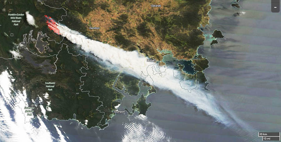
This image of smoke from the Gell River Fire was captured by a satellite on January 4, 2019. Since then the activity has decreased due to a change in the weather. The red dots indicate heat detected by the satellite.
Gell River Fire Tasmania helicopter
Photo by Andrew MacDonald
Gell River Fire Tasmania helicopter
Photo by Andrew MacDonald
Gell River Fire Tasmania
Gell River Fire. Photo by Andrew MacDonald
This image of smoke from the Gell River Fire was captured by a satellite on January 4, 2019. Since then the activity has decreased due to a change in the weather. The red dots indicate heat detected by the satellite.

Initial attack on Woolsey Fire was hampered by shortage of resources

The quickly spreading Hill Fire started 21 minutes before, 15 miles to the west

3D Map Woolsey Fire Ventura County Los Angeles d-D
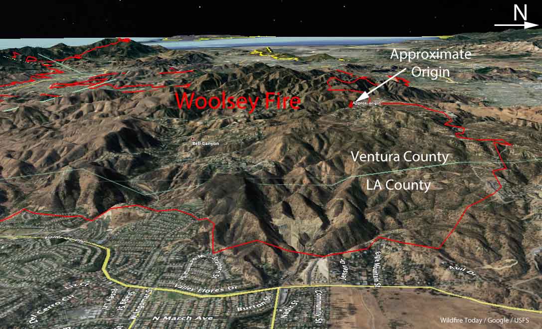
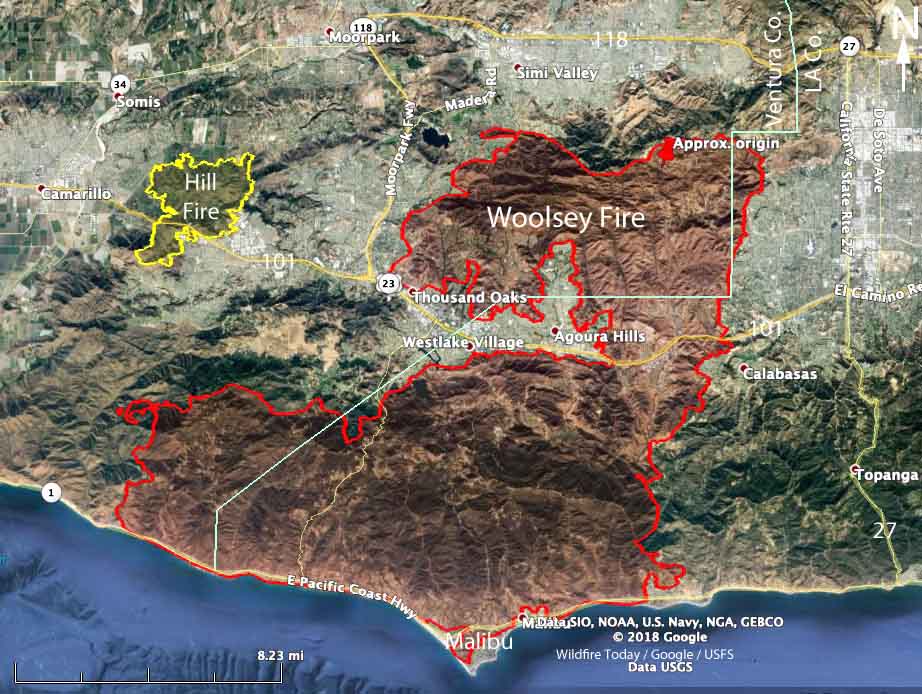
3-D Map of the Woolsey Fire. The red line was the perimeter. Click to enlarge.

No wildfire starts at the right time, but the fire that Los Angeles County describes as the worst in the county’s modern history began at a particularly bad time. The Woolsey Fire was reported on November 8, 2018 21 minutes after the Hill Fire about 15 miles to the west. Both began in Ventura County in Southern California while strong Santa Ana winds were blowing out of the north and northeast. The Camp Fire which started about 8 hours earlier in Northern California had already destroyed thousands of homes in the Paradise area.

The incident commanders decided that the Hill Fire had the greatest immediate potential to affect lives and property — there were fewer homes close to the point of origin of the Woolsey Fire.

Progression map Woolsey Fire
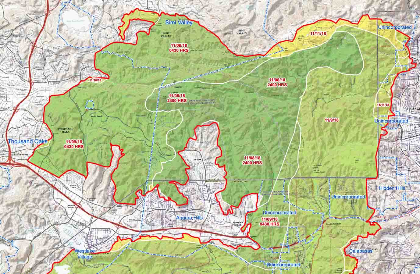
Progression map of the north side of the Woolsey Fire, prepared by the Incident Management Team. Click to enlarge.

With resources flooding in to the Hill Fire, the first unit to arrive at the Woolsey fire got there almost 20 minutes after it was reported. In a densely populated part of the country where it is common to have hundreds of engines on a rapidly spreading wildfire within hours, after 60 minutes only 11 engines were on scene.

About 12 minutes after it was reported, the quickly growing Hill Fire jumped the 101 Freeway but 2 hours later it hit an area that had burned in 2013 and slowed, allowing firefighters to make significant progress. By midnight the incident commander shifted some resources over to the Woolsey Fire which had spread to Agoura Hills.

By 4 a.m. on November 9 pushed by increasing winds gusting to 70 mph, the Woolsey Fire crossed the 101 Freeway and at the end of the day had spread to the Pacific Ocean, 20 miles from where it started a little more than 24 hours before.

Map Woolsey Fire Ventura County Los Angeles
Map of the Woolsey and Hill Fires.

Stats: Hill Fire / Woolsey Fire

  • Acres: 4,500 / 97,000
  • Structures destroyed: 4 / 1,500
  • Fatalities: 0 / 3
  • Length (miles): 4 / 20

The Hill Fire had far more firefighting resources assigned during the first six hours, compared to the Woolsey Fire which was starved of engines and aircraft during that period. But the Hill Fire spread into a previous burn and slowed which made the firefighters’ jobs easier.

Below are excerpts from an article in the Los Angeles Times about the fire.

…Veteran firefighters say it was a once-in-a-lifetime event.

“In my 30 years of experience, I’ve never seen a fire that explosive,” [Los Angeles Fire Department Deputy Chief Trevor]  Richmond said. “Seeing how quickly that fire traveled to Agoura Hills and Oak Park and Thousand Oaks and jumped the freeway the next morning, and in four hours, it’s burning kelp beds in the Pacific Ocean — that’s pretty incredible.

“This one was the big one,” he said.

[…]

[Ventura County Fire Assistant Chief Dustin] Gardner said he was repeatedly on the phone begging the state to send more tankers to Ventura County, arguing the Woolsey fire had the potential to hit Malibu, not realizing how bad the Camp fire had become. Within the first hour of the Hill fire, the incident commander doubled his order from four to eight air tankers.

Soon after, a dispatcher asked him if they could divert one of his fire’s tankers to the Woolsey fire, which was potentially going to threaten homes and businesses in Simi Valley.

“You can divert one of the air tankers,” Ventura County Fire Assistant Chief Chad Cook, the Hill fire incident commander, said. “We’ll keep the rest of them here.”

About 40 minutes later, at 3:37 p.m., a dispatcher told the Hill fire incident commander two air tankers and two helitankers would soon arrive to fight the blaze. Only a few minutes later, the Woolsey incident commander was told by a dispatcher that the region had no more air tankers it could send, but that there were multiple helicopters available.

About an hour later, the Woolsey incident commander seemed to be frustrated by his tanker requests going unfilled.

“I’d like to talk to my neighboring fire (commander) and see if I can get some from him,” the Woolsey incident commander told his aerial coordinator over the radio at 4:26 p.m.

“Correct, sir,” the aerial coordinator said. “We’ve been trying to negotiate resource sharing. We’ll see how that goes.”

But the Woolsey fire began spreading at a much faster pace — with far fewer firefighters on the ground than were battling the Hill fire…

Thanks and a tip of the hat go out to Tom.
Typos or errors, report them HERE.

Forecasters expect the West to be warmer and drier than average later in January

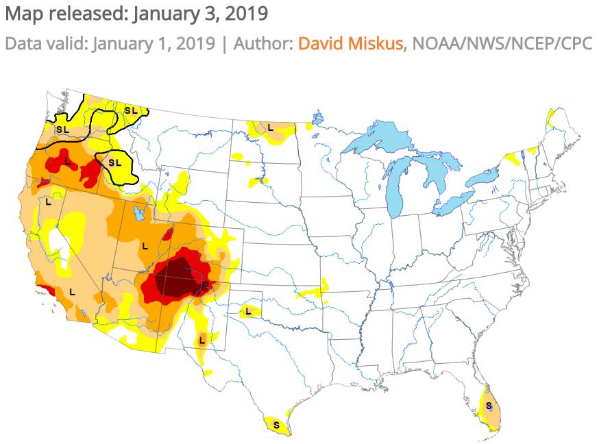
The east should be cooler, while the Drought Monitor shows Severe to Exceptional drought in the Four Corners area.

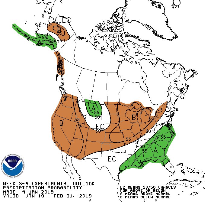
outlook for precipitation January
The outlook for precipitation in the second half of January.

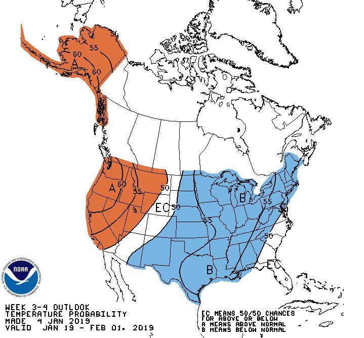
The three to four-week outlook issued January 4 for the second half of January predicts warmer and drier conditions in the Western United States. Areas east of the Rocky Mountains should be cooler. According to the National Weather Service Climate Prediction Center this is tied to tropical teleconnection responses and a building 500-hPa ridge forecast over northwestern North America.

Probably as a result of the partial shutdown of the federal government the Predictive Services section at the National Interagency Fire Center has not issued an updated Wildland Fire Potential Outlook at the beginning of the month as is customary.

outlook for temperature January
The outlook for temperature in the second half of January.

Below is the Drought Monitor released January 3, 2018.

Drought Monitor
The Drought Monitor shows Severe to Exceptional drought in the Four Corners area.

Drought Monitor legend

Welcome to the 11th year of Wildfire Today

Wildfire Today created 11 years ago in 2008Eleven years ago today I wrote the first article on Wildfire Today. Since then it has been a fun, interesting, and at times a challenging journey. As this new year begins I am thankful for our readers, many of whom have been with us since the beginning, and our sponsors who make it possible to keep the doors open.

Six months after that initial article @WildfireToday was born on Twitter, June 2, 2008.

Hop on and join us in year number eleven!

Large wildfire in Tasmania sends smoke into Hobart

The fire near Gell River has burned over 37,000 acres

A large wildfire that started in the Gell River area in the Australian state of Tasmania has burned more than 37,000 acres (15,000 Ha) mostly in the Franklin-Gordon Wild Rivers National Park. The fire is approaching Lake Rhona and Gordon River and has sent embers into Mount Field National Park. The blaze was burning button grass but has moved into timber and peat areas, which could result in it persisting for months.

Dense smoke that spread toward the southeast heavily impacted Hobart as you can see in this satellite photo.

Tasmania Fire Gell River
Wildfire in southwest Tasmania that started near Gell River, currently burning in Franklin-Gordon Wild Rivers National Park. The red dots indicate heat detected by the satellite. Photo, January 4, 2018.

Paul Black of the Parks and Wildlife Service said, “We’ll be considering further retardant drops, back-burning operations, a lot of water bombing, and hot and cold trailing of the active edge of the fire.”

Clouds and cooler weather moved in and slowed the spread of the fire on January 4.

smoke Hobart Tasmania Fire Gell River
Wildfire smoke from the Gell River Fire impacts Hobart, Tasmania, Australia. Photo by Olivia Hicks.