Milepost 22 Fire threatens homes in Central Washington

The fire is near the Columbia River 19 miles east of Ellensburg

Above: The Milepost 22 Fire, Wednesday night. Photo by Washington State DNR.

(UPDATED at 10:53 a.m. PDT June 21, 2018)

The Washington State DNR announced at about 10 a.m. Friday that the Milepost 22 fire has burned approximately 4,000 to 5,000 acres.

****

(Originally published at 7:32 a.m. PDT June 21, 2018)

A fire that started late Wednesday afternoon is threatening homes in Central Washington. The Milepost 22 Fire was first reported about two miles north of Interstate 90. Since then it has burned at least 1,750 acres, according to the Washington State Department of Natural Resources.

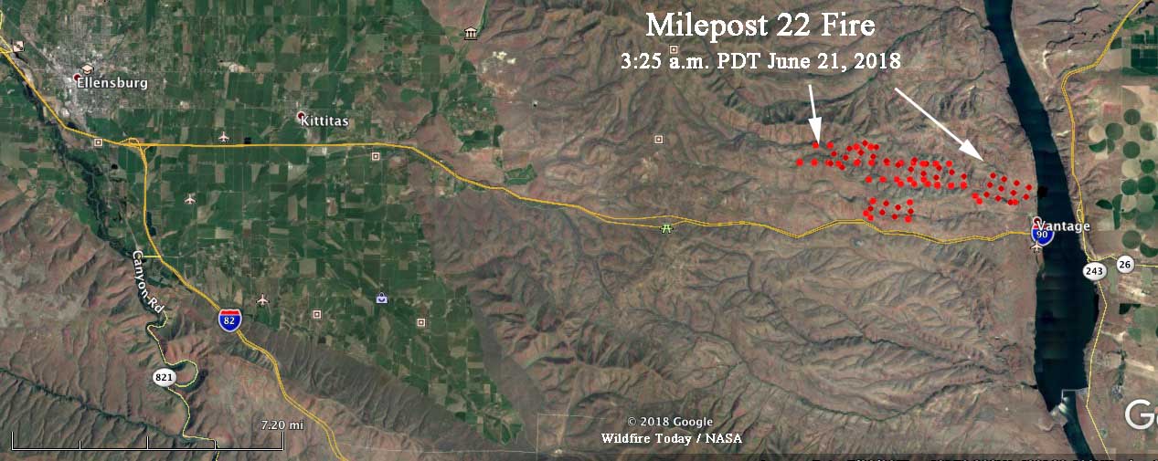
The blaze is just west of Wanapum Lake on the Columbia River at Vantage, Washington and is on both sides of the Vantage Highway which is parallel to and north of Interstate 90. The highway was closed Wednesday afternoon due to downed power lines, but the Interstate remained open.
map Milepost 22 Fire
Map showing heat detected on the Milepost 22 Fire by a satellite at 3:25 a.m. PDT June 21, 2018. Click to enlarge.

Thursday morning the DNR reported that the fire was still growing. A Type 3 Incident Management Team will assume command of the fire at 6 a.m. Thursday.

The weather forecast for the fire area Thursday calls for temperature in the mid-80s, relative humidity in the low 30’s, and wind out of the northwest at 11 to 18 mph gusting at 18-25.

Milepost 22 Fire
The Milepost 22 Fire, Wednesday night. Photo by Washington State DNR.

Incident Commander on the 416 Fire interviewed as the team’s assignment ends

Since the fire started June 1 about 10 miles north of Durango, CO., it has burned over 34,000 acres west of Highway 550

Above: An undated photo of the 416 Fire, from Inciweb.

After being assigned to the 416 Fire for two weeks Todd Pechota’s Type 1 Incident Management Team will demobilize Friday morning and transition to Joe Reinarz’s National Incident Management Organization (NIMO) team. Mr. Pechota is the Forest Fire Management Officer on the Black Hills National Forest but is currently detailed into his former bosses job which is vacant, the Forest Supervisor position.

File photo of Forest FMO Todd Pechota on a prescribed fire in 2016. Screen grab from a video by Bill Gabbert.

As Mr. Pechota’s time on the 416 Fire wound down, Alex Semadeni, a writer for the Durango Herald, interviewed the Incident Commander.

Below is an excerpt:

“We were playing a bit of a tough hand based on weather and topography and fuels,” Pechota said. “In many, many places of the fire, we just couldn’t land on a place where being able to take care of them (firefighters) in the event of an injury was an acceptable risk.”

Pechota was also concerned about the fire’s proximity to homes and the city of Durango in general. The fact that the fire was across the highway from the 2002 Missionary Ridge Fire wasn’t lost on him either.

“It’s kind of eerie,” he said. “If you’re a student of fire, you would look across the road and see the burn scar of Missionary Ridge. And what is the thing about Missionary Ridge that people remember? Some people it may have been the flooding. Some people it may have been the size. Some people it may have been the huge fire whirl that went across Vallecito. But many of us, the thing that we remember is that somebody died fighting the fire.

“That’s one of those things that when you’re asking young men and women to go engage a fire that you look right across the road and there is the burn scar from an event that took somebody’s life. It heightens our awareness, it heightens our sensitivity of operations, all those kind of things.”

416 Fire chinook helicopter
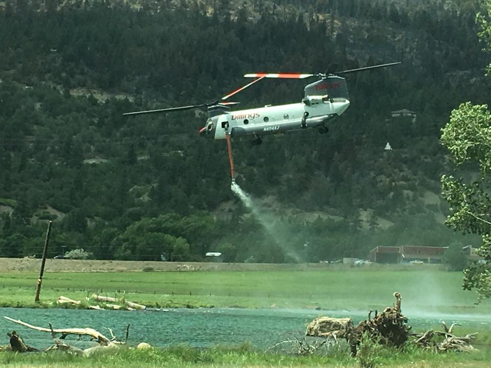
A Billings Helicopters Chinook departs from a water source after refilling their new internal water tank to help suppress the 416 Fire.

Weather slows fire activity in Western United States

Above: Accumulated precipitation over the last seven days, June 12-18, 2018. 

Moderating weather over the last seven days has helped firefighters make progress on some of the fires in Colorado, Wyoming, New Mexico, and Utah. Today’s national Situation Report showed little or no increase in the size of wildfires in those four states. The 416 Fire in southwest Colorado and the Badger Creek Fire in southern Wyoming released a total of 345 personnel over the last 24 hours.

Todd Pechota’s Type 1 Incident Management Team is currently assigned to the 416 Fire, but Joe Reinarz’s NIMO team has been mobilized for the fire, which could be an indication that they expect it to be a long term incident. The west side of the fire has spread into steep, remote terrain above 8,000 feet as it grows closer to an 11,000 to 12,000-foot ridge five miles away. Much of the ridge is above the timber line and may eventually, with patience over time, serve as a barrier. Mr. Reinarz’s team team will transition on Friday.

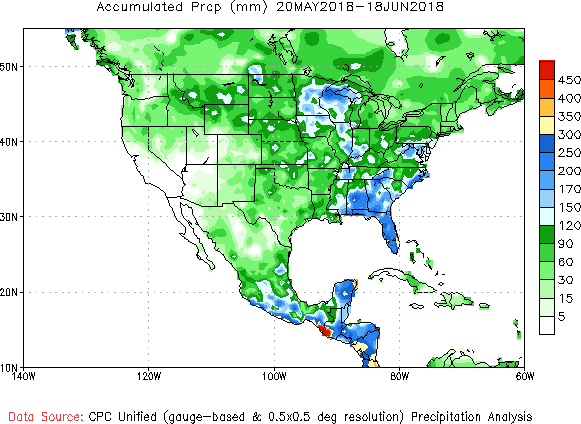
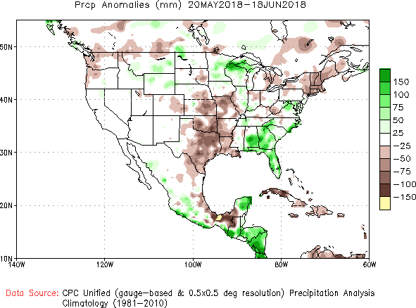
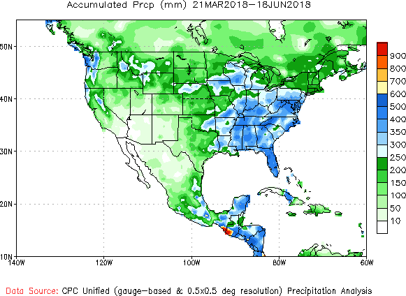
Below, National Weather Service graphics show the observed precipitation and the departure from normal for the last 30 and 90 days.

precipitation 30 days
Accumulated precipitation, May 20 through June 18, 2018. NWS.
precipitation 30 days
Precipitation departure from average, May 20 through June 18, 2018. NWS.
precipitation 90 days
Accumulated precipitation March 21 through June 18, 2018. NWS.
precipitation 90 days
Precipitation departure from average, March 21 through June 18, 2018. NWS.

Satellite photos of wildfires in Siberia

Posted on Categories UncategorizedTags ,

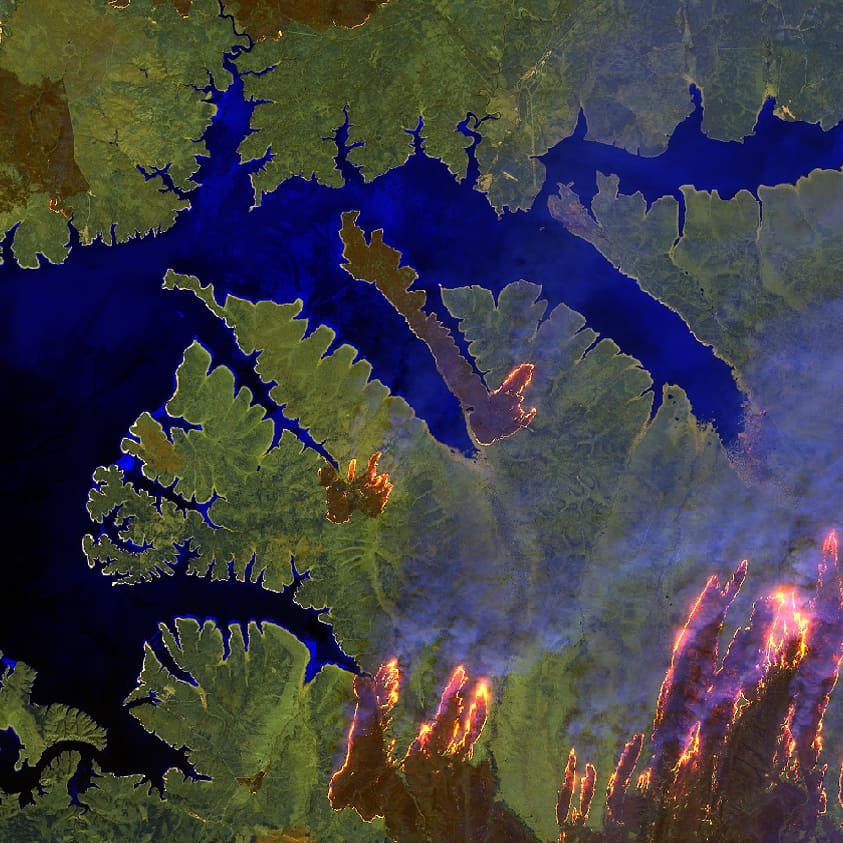
Two photos taken May 9 by the European Space Agency’s Sentinel 2 satellite of wildfires in Siberia highlight flames, and in the other, smoke. The sensors used were RGB-natural color and SWIR-enhanced infrared.

On that date wildfires blazed in Russia’s Far East around Komsomolsk-on-Amur, a city of nearly 264,000. The Siberian Times published images of the fires.

ESA satellite photo wildfire siberia

Wildfire threatens urban area in Sweden

Above: a water scooping air tanker based in Italy drops water on a fire in Stockholm, Sweden June 15, 2018.

A wildfire in the Nacka area of Stockholm, Sweden burned close to an urban area on Friday. In addition to firefighters on the ground, scooping air tankers from Italy were seen working the fire.

Local authorities said Saturday morning that the fire’s spread had been stopped:

We are in place and work with the remaining fires. It no longer burns up in trees or bushes, but down in the vegetation, moss roots and the like. We have the fire surrounded and it is controlled, but there is a lot to do in the area, “says operative manager Per Tillander, at Södertörn’s Fire Defense Association.

The fire department will remain at least throughout the day and probably also on Sunday.

There is still smoke from the fire, which covers 90 hectares, but the smoke is much more diluted than yesterday, and it is more about smoke smell than smoke.

More moderate weather affects Trail Mountain Fire in Utah

Above:  The Redding Hotshots conduct a safety briefing before beginning their assignment on the Trail Mountain Fire. U.S. Forest Service photo.

Below is information about the Trail Mountain Fire in central Utah, provided by the Incident Management Team Saturday morning, June 16, 2018.


“[Friday], at approximately 12:00 p.m., Emery County Sheriff’s Office and the Utah Highway Patrol closed Highway 31 through Huntington Canyon but it remained open up to Bear Creek Canyon. Increased fire activity had created thick smoke and poor visibility on the highway. Additionally, firefighters and equipment were working directly along the highway. Despite this increased fire activity, evacuations were lifted for the Trail Canyon community. Highway 31 will be constantly monitored today and reopened as soon as conditions allow.

“Firefighters contained a large portion of the fire perimeter Friday on the southern portion near Trail Mountain and Whetstone Creek. The overall percentage of containment does not reflect this containment yet due to fire growth of about 3,000 acres yesterday into Little Bear Canyon and up Mill Fork Canyon. The fire also reached the ridge just south of Crandall Canyon. Firefighters thinned vegetation and installed sprinkler systems around the Crandall Canyon Mine Memorial and adjacent areas.

“Saturday’s cloudy weather, cooler temperatures, and higher relative humidity should reduce fire activity but will have little effect on the dead and dry vegetation that has allowed the fire spread. Possible thunderstorms could bring gusty winds that would also help the fire spread.”