Multiple firefighter fatalities on the Yarnell Fire in Arizona

(This article was updated numerous times over a couple of weeks, beginning June 30, 2017. To read it in chronological order, scroll to the bottom. The first entry was posted at 9:32 p.m. MDT, June 30, 2013)

***

(UPDATED at 2:26 p.m. MDT, July 15, 2013)

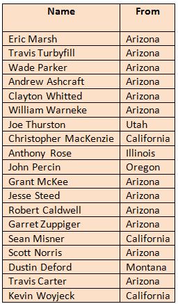
Most of the funerals are over for the 19 members of the Granite Mountain Hotshots that were killed on the Yarnell Hill Fire June 30. From information provided by the incident management team that organized the services, the firefighters are listed below.

19 Granite Mountain Hotshots

The incident management team has posted hundreds of photos of the memorial service, the procession, and the planning.

****

(UPDATED at 10:20 a.m. MDT, July 5, 2013)

An article in the LA Times has some previously unpublished information about the last moments of the Granite Mountain 19. Apparently the crew was attempting to establish an anchor point, presumably at what had previously been the heel, or rear of the fire. They were constructing fireline and may have been burning out that day. A photo that I had not seen before that was texted to the father of one of the firefighters father at 4:04 p.m. shows a firefighter in what appears to be a burned area, looking at the fire. The text said: “This thing is running straight for Yarnell”. By 4:47 p.m. the Arizona State Forestry Division received word sent up through channels that fire shelters had been deployed on the Yarnell Hill Fire.

Below is an excerpt from the article:

Team leader [Crew Superintendent] Eric Marsh told his commanders via radio that the group had a predetermined safety zone. “He was calm, cool and collected,” Ward said. “They all stayed together. Nobody ran.”

Moments later — Ward doesn’t know how long — Marsh radioed his superiors a second time. This message was different: He and his men were going to deploy the small emergency shelters that were their last resort against an advancing fire.

“From what I’ve heard, it was the calmest they’ve ever heard Eric,” Ward said. “They were in a tight spot and everyone knew this was going to be a bitch. But his voice was very calm: ‘We’re deploying.’ ”

Fire officials tried desperately to save the men.

Danny Parker, a fire battalion chief from the nearby Chino Valley Fire Department whose son Wade Parker died with the other Granite Mountain crew members, said he learned from colleagues that his son was in trouble.

“They had deployed their emergency shelters, and helicopter crews were trying desperately to spot them through dense smoke,” he said, wiping tears from his eyes.

He said he was told that Sikorsky helicopters were making water drops in areas where they thought the trapped firefighters might be.

“They weren’t sure about the men’s position because they couldn’t see through the smoke,” he said.

Their bodies were found in a single group, huddled together.

****

An Associated Press article provides some information about the autopsies of the firefighters:

Cari Gerchick, a spokeswoman for the Maricopa County Medical Examiner’s Office in Phoenix, said the Hotshots died from burns, carbon monoxide poisoning or oxygen deprivation, or a combination of the factors. The autopsies were performed Tuesday, but more detailed autopsy reports should be released in three months, pending lab work.

****

The Prescott Fire Department has brought in an Incident Management Team to help plan the events related to the deaths of the firefighters. They have established a web site that appears to be devoted to the scheduled events, as well as a Facebook page for photos and other information.

Their web site said that on Sunday, June 7 the remains of the 19 fallen fire fighters will be escorted with full Honor Guard from Phoenix to the Yavapai County Medical Examiner’s Office in Prescott. The procession will begin at 10 a.m. but the exact route is still being planned.

AZCentral has an article about a photo that has stirred some controversy. It shows flags draped over what appear to be body bags containing the 19 dead firefighters. They said the photo appeared on a Facebook page described on the site as “a community, news, and donation page (that) is not directly related to the Granite Mountain Hotshots personally.” AZCentral did not provide a link to the page or give its exact name but they do have a copy of the photo.

****

(UPDATED at 7 p.m. MDT, July 3, 2013)

(Information about the Yarnell Hill Fire itself is in our main article about the fire. This one is devoted to the 19 firefighters that died.)

The memorial service, not the funerals, for the Granite Mountain 19 will be held Tuesday, July 9 from 11 am to 1 pm at the Tim’s Toyota Center in Prescott Valley. There will be seating for 6,000 attendees with room for overflow outside.

****

According to the Professional Fire Fighters of Arizona, the 3 official fundraising efforts to help the families of the fallen have raised about $700,000.

  • The 100 Club has raised approximately $500,000.
  • The Wildland Firefighters Foundation (52 Club) has raised approximately $120,000.
  • The United Phoenix Fire Fighters and Prescott Firefighters Charities have raised approximately $80,000. They can receive donations through PayPal.

In the Prescott/Yarnell area, two local fundraising events have been scheduled for this week.

  • 4th of July Fireworks at Pioneer Park from 12 noon to 10 pm.
  • Whiskey Row Street Dance on Saturday, July 6th 5-11pm

Other fundraising events will be announced in the days to come.

****

Residents of Yarnell can obtain updates on the status of their property by calling the County Emergency Operations Center at 928-777-7481.

****

In the first 24 hours following the entrapment there were reports that up to six people had been injured and were being treated in hospitals, but there were no injuries, according to a spokesperson for the fire. There were 19 fatalities.

****

The crew carriers of the Granite Mountain Hotshots were removed from the fire where they had been parked by the crew, to Prescott today. Prescott Fire, Prescott Interagency Hotshot Crew, and Ironwood Hotshot Crew escorted the group from the Yarnell Hill Fire to the City of Prescott.

****

On Sunday, July 6, the Granite Mountain 19 will be escorted from the Medical Examiner’s Office in Phoenix to the Medical Examiner’s Office in Prescott. There will be 19 hearses, each with an honor guard member to accompany the fallen firefighter.

****

The last members of the nine person team that will be investigating the fatalities of the 19 firefighters on the Yarnell Hill fire arrived Tuesday and received an inbriefing in Phoenix from the Arizona State Forester. One of their main objectives will be to explore lessons learned and how to prevent a similar tragedy in the future.

Described as an “independent investigation” in a news release, it will be led by Florida State Forester Jim Karels. Mike Dudley, Acting Director of Cooperative Forestry for the USDA Forest Service, will be the secondary team lead. Other entities participating in the investigation include the U.S. Forest Service’s Missoula Technology and Development Center, the Missoula Fire Department, the Bureau of Land Management, and the Arizona Division of Occupational Safety and Health. Some of the team members are technical specialists and fire behavior analysts.

The local liaisons to the nine-member Yarnell Hill Investigation Team are Arizona State Forester Scott Hunt and Prescott Fire Chief Dan Fraijo.

****

Carrie Dennett, a Fire Information Officer with the Arizona State Forestry Division, said the Arizona Dispatch Center first received a call at 4:47 p.m. June 30, that firefighters on the Yarnell Hill Fire had deployed fire shelters. The Dispatch Center was not in direct communication with firefighters on the ground at the fire. The information would typically have been relayed from the local Yarnell Hill Fire organization up through lower level dispatch offices.

Another spokesperson for the fire said the fatalities occurred between where the fire was at the time and the town. That would put the firefighters N, NW, or E of the town — between an approaching thunderstorm and the town. (UPDATE July 15, 2013: the possible but unconfirmed location is: Lat: 34.220392 Long:-112.777690 )
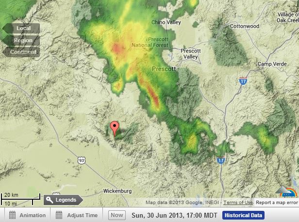
Radar at 5 pm MDT, June 30, 2013 The pointer is at Yarnell, Arizona.
Radar at 4 pm MST, June 30, 2013. The pointer is at Yarnell, Arizona. The thunderstorm was moving toward the southwest. Radar image from WeatherUnderground.

Continue reading “Multiple firefighter fatalities on the Yarnell Fire in Arizona”

Arizona: Yarnell Hill Fire

(This article was updated numerous times over six days, beginning June 30, 2017. To read it in chronological order, scroll to the bottom. The first entry was posted at 6:15 p.m. MDT, June 30, 2013.)

***

(UPDATE at 9:35 a.m. MDT, June 5, 2013)

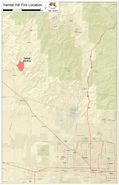
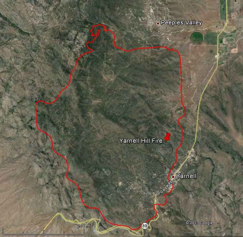
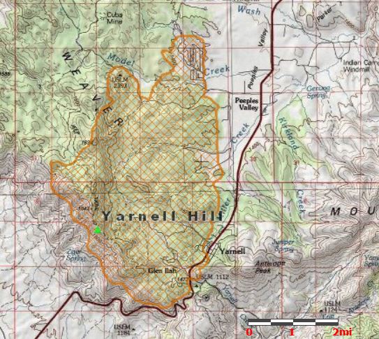
Firefighters are making good progress on the Yarnell Hill Fire. Two maps released yesterday show the exact perimeter in detail and where fireline had been constructed when the maps were made on July 3. Today the IMTeam is calling the fire 80 percent contained. One of the maps says it has burned 8,165 acres, which is a revision from the 8,400 figure that has been used for several days and is still shown on InciWeb.

Evacuation orders were lifted for residents of Peeples Valley at 6:30 p.m. on Thursday, July 4. Only residents with valid identification will be allowed access into the community.

Residents needing information regarding the status of their properties can contact the Yavapai County Sheriff’s Office at 928-427-6475.

We have more information about the deaths of the 19 firefighters and the weather that appeared to be a factor in the tragedy.

****

(UPDATE at 7:30 p.m. MDT, July 3, 2013)

State Highway 89 remains closed between Date Creek Road south of Yarnell to mile marker 283 north of Peeples Valley.

There are 596 personnel assigned to the fire, including eight crews, 44 engines, and 9 helicopters.

The MODIS satellite found no concentrations of heat when it overflew the fire at 12:25 p.m. Wednesday. It can detect heat sources larger than 30 meters across.

Wednesday evening the Incident Management Team said the fire is 45 percent contained. This is a jump from the 8 percent number they were using yesterday. (But, refer to our explanation below about containment percentages.) The number of acres has not changed for a couple of days, and remains at 8,400.

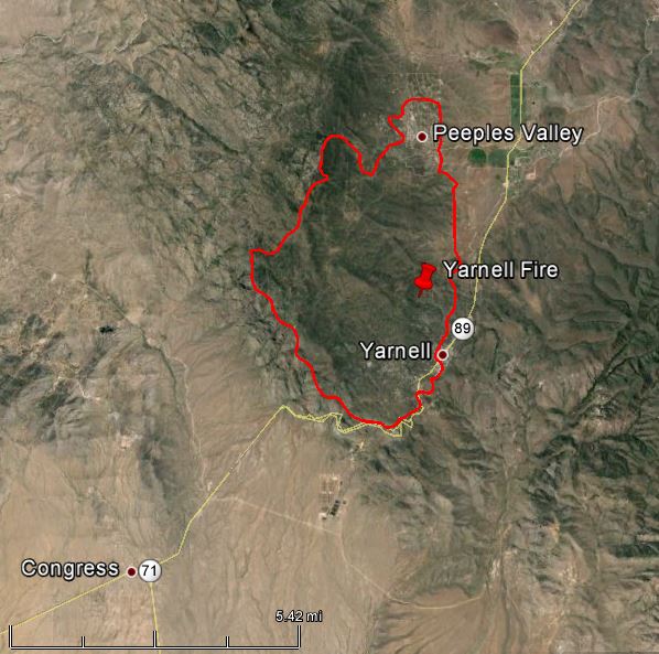
map of Yarnell Hill Fire, July 3, 2013
IMTeam map of Yarnell Hill Fire, July 3, 2013

The IMTeam had not released a map of the fire since July 1, until they released the one above today. HERE is a link to a larger version of the map.

****

(UPDATE at 7:50 a.m. MDT, July 3, 2013)

Map of Yarnell Fire, July 2, 2013
Map of Yarnell Hill Fire, July 2, 2013. The source of the perimeter data was a GPS device.

The Yarnell Hill Fire spread very little Tuesday and the Incident Management Team kept the reported acreage the same, at 8,400. The MODIS satellite detected no concentrations of heat larger than 30 meters across when it overflew the fire at 12:20 a.m. Wednesday. The IMTeam is estimating that 50 primary structures have burned, but this number may still be revised after assessments are complete. Approximately $1.75 million has been spent on the fire so far.

The Team selected 8 percent as the containment percentage they are distributing to the public. Until late yesterday they said there was no containment, meaning no fire line had been constructed and held. Until a few years ago, the containment percentage was an actual statistic, the amount of fire line completed and held compared to the fire line that still needed to be built, but recently it has become politicized and meaningless. There may still be some IMTeams that accurately report containment, and hopefully the IMTeam managing this fire is one of them. But since the public has no way of knowing, there is no point in getting excited about a containment percentage figure. More information about describing a fire as contained, controlled, or out is at the National Wildfire Coordinating Group’s web site.

Below is an excerpt from an update issued by the IMTeam Tuesday night at 10 p.m.:

Today, firefighters made good progress on the northeast corner and the fire perimeter near Yarnell. Two hot shot crews scouted the western flank until the threat of thunderstorms caused them to move to safer areas. Creeping and smoldering continued around the structures, primarily in the afternoon, and some areas around structures are still holding enough heat to be a concern. A plan is being developed to restore utilities and infrastructure to the affected communities. Contingency lines were scouted in case the fire becomes active again. Tonight, crews will be patrolling in the developed areas and working on flareups and visible heat.

****

(UPDATE at 3:02 p.m. MDT, July 2, 2013)

During the 11:27 a.m. overflight today, the MODIS satellite did not detect any large concentrations of heat larger than 30 meters square on the Yarnell Hill Fire, but there could still be a lot of work left for firefighters, including constructing fireline. With so much uncompleted line, there is still the possibility for the fire to continue to spread.

Map of Yarnell Fire, July 2, 2013,
Map of Yarnell Fire, July 2, 2013, showing the approximate perimeter of the fire. Provided by GEOMAC
Map of Yarnell Fire, July 2, 2013
Map of Yarnell Hill Fire, showing the approximate location of the fire perimeter at 1 a.m. MDT, July 2, 2013.
This map of the Yarnell Fire was used in a public meeting July 2, 2013. The time that the data was acquired, is not known; it may have been prepared before the updated data in the other two maps above was obtained.
This map of the Yarnell Hill Fire was used in a public meeting July 2, 2013. The time that the data was acquired is not known; the map may have been prepared before the updated data in the other two maps above was obtained.

The Yarnell Hill Fire was less active Monday than it was on Sunday when it rapidly overran the position of the Granite Mountain Hotshots, killing 19. (More information about the fatalities.)

Air tankers and firefighters worked the north perimeter of the fire where it continued to spread, and 5 helicopters assigned to the fire dropped water on hot spots in support of the firefighters. Efforts continued to secure the east flank to protect other homes at risk.

The Incident Management Team reported that 50 primary structures have burned in the fire. As of 9:30 p.m. on Monday they said it had blackened about 8,400 acres, was zero percent contained, and was being fought by about 500 personnel.

Clay Templin’s Type 1 Incident Management Team assumed command of the fire at 6 p.m. Monday.

Fire officials will hold Community Meetings on July 2: 11 a.m. at Wickenburg High School and 3:30 p.m. at the Prescott High School.

****

(UPDATE at 7:30 p.m. MDT, July 1, 2013)

The Incident Management Team reports that an estimated 200 homes and other structures burned Sunday in Yarnell. The Yarnell Fire Department will continue to assess the damage Monday.

The New York City Fire Department is sending five members of their Incident Management Team to assist in managing the Yarnell Fire.

****

(UPDATE at 1:46 p.m. MDT, July 1, 2013)

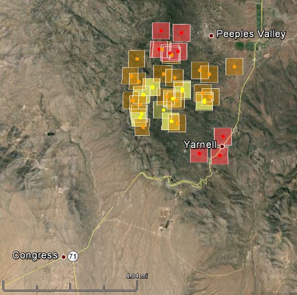
3-D map of Yarnell Fire at 3:10 a.m. MDT, July 1, 2013
Map of Yarnell Fire at 3:10 a.m. MDT, July 1, 2013

The maps of the Yarnell Fire above show heat, represented by the square icons, detected by a satellite at 3:10 a.m. MDT, July 1, 2013. The red squares were the most recently detected. All of the icons can be as much as a mile in error.

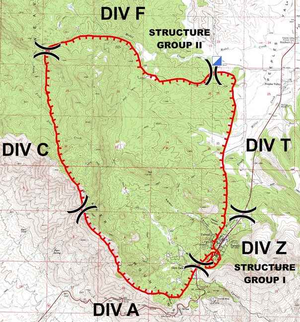
IMTeam's map of Yarnell Fire, July 1, 2013
Incident Management Team’s map of Yarnell Fire, July 1, 2013. The city of Yarnell is just to the left, or west, of where it says “DIV Z”.

The Incident Management Team reports the fire has burned 8,374 acres and has zero containment. They also officially confirmed on Monday morning the fatalities that occurred on Sunday:

A fire crew had to deploy their fire shelters late yesterday afternoon after strong winds pushed the fire to their position and 19 firefighters died in the line of duty.

Mike Reichling of the Arizona Forestry Division said the early report of about half the structures in Yarnell being destroyed in the fire is an exaggeration. He said the Yavapai fire chief was assessing the destruction.
Continue reading “Arizona: Yarnell Hill Fire”

A fresh look at the tragic Dude Fire

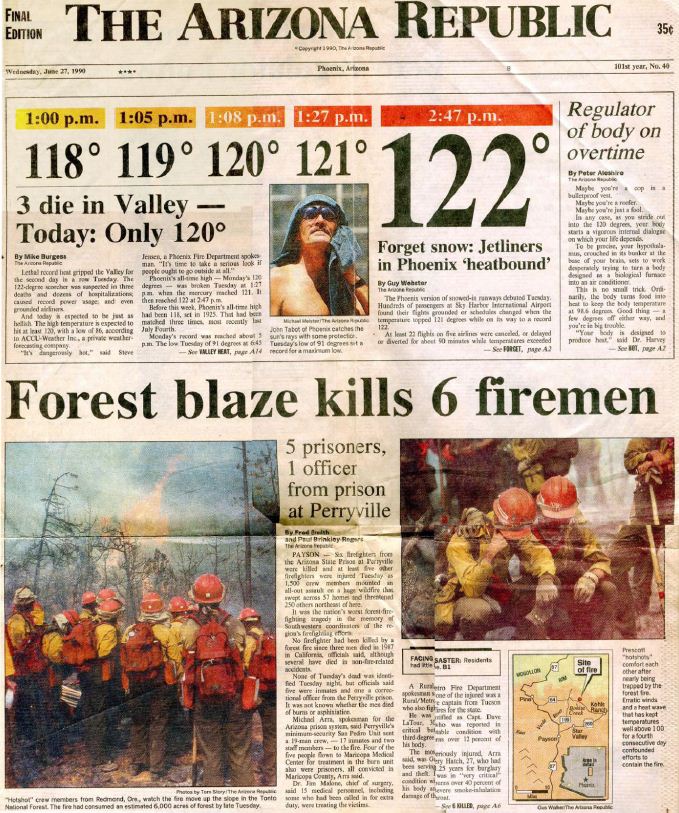
Dude Fire Newpaper
The front page of The Arizona Republic, June 27, 1990. (click to enlarge)

A journalist, who is also an editor at Time, Inc., has taken a fresh look at the Dude Fire, 23 years after 6 firefighters were entrapped and killed in Walk Moore Canyon north of Payson, Arizona, June 23, 1990 — a day when the temperature in Phoenix reached 122 degrees, grounding jetliners because there was no reliable data confirming that fully loaded commercial aircraft could operate in that kind of heat.

Jaime Joyce conducted extensive research about the fire, talking to firefighters who survived, families that had to bury their sons, investigators who determined what happened and how the equipment functioned, and yes, attorneys who dealt with legal issues long after the funerals. She unearthed facts, stories, and perspectives that never made it into the official reports.

Firefighters can learn many lessons from reading the investigation report which was completed less than a month after the accident by Dick Mangan, Ted Putnum, Patricia Andrews, and six others.

Reading articles like the one written by Ms. Joyce can also impress upon a firefighter, especially those in the early part of their careers, that things CAN go wrong, horribly wrong, and how important it is to be responsible for your own safety (if you SEE something, SAY something) and to maintain situational awareness.

Ms. Joyce’s account, published at The Big Roundtable, brings to light details that would not normally be found in government reports — it shines a light on the accident from a different perspective. It also covers the battles fought by survivors and the victims’ families for various forms of restitution, largely futile, that persisted for years after the smoke cleared.

Below is an excerpt from the article:

****

“…The burnover lasted about 15 minutes. [Fire] shelters are designed to withstand temperatures up to 1,200 degrees. It must have been hotter in the heart of the flame front, since some of the shelters started to delaminate, the aluminum exterior separating from the fiberglass lining.

Davenport, Love, and LaTour stayed put. They waited inside their shelters until the area cooled down. LaTour used his radio to call for help but no one answered on any of the channels. Through the chatter, he heard someone say that help was coming. When the men finally emerged about 45 minutes later, shaky and weak, they followed the dozer line toward Control Road, their tattered shelters wrapped around their bodies like capes. As they walked, LaTour told the men not to look at the devastation that surrounded them. “We have to get out,” he said.

On the way down, they met Hoke, who was still inside his shelter. He emerged from his cocoon and joined the survivors. Ellis appeared next. As he walked toward the men, with his shelter tied around his forehead, his skin and clothing burned, the life drained out of him. “I’m dead,” Ellis told the others, and then he sat down on a log and died.

No one was waiting for the men at Control Road. Again, LaTour radioed for help and got no response. He headed west with his men about 200 yards, which is where a Forest Service truck met them. The men climbed into the bed of the pickup and were taken to a clearing, where they were given first aid. They were brought to the base camp next and flown by helicopter to Maricopa Medical Center, in Phoenix.

Before the flame front hit, the Alpine Hotshots foreman, Jim “J.P.” Mattingly, and his men had been conducting a burnout in Walk Moore Canyon just north of Perryville, using gasoline-filled drip torches to light small fires in order to clear vegetation and stop the spread of the blaze. When Mattingly saw the fire approaching, he had ordered his men to run north up the canyon, in the opposite direction of Perryville and Navajo. He had stepped away from the safety zone to take in his surroundings when he came across Paul Gleason, superintendent of the Zigzag Hotshots, and Paul Linse, superintendent of Flathead. Mattingly told the men that Perryville and Navajo had gone back toward Control Road, and that nobody else should be heading north up the canyon. But Gleason wanted to make sure no one was left. “Do you mind if we go back that way?” he asked. No one objected.

Their actions defied human instinct…”

(end of excerpt)

****

We contacted Ms. Joyce to ask her how she became interested in the Dude Fire. In addition to granting us permission to publish an excerpt, she was kind enough to provide the following answers to our inquiry:
Continue reading “A fresh look at the tragic Dude Fire”

Driver training for Bay Area Search and Rescue

I want one of these.

Bay Area Search and Rescue in the United Kingdom conducts driver training with their Hagglund BV206 all terrain amphibious vehicle.

Here’s more information about those folks:

We are an all Terrain Rescue Team working in partnership with Cumbria Fire & Rescue and Lancashire Fire & Rescue. We specialise in quicksand, snow and flood rescue and all-terrain recovery and support using our Hagglund BV206 all terrain amphibious rescue vehicles, 4×4’s and trained personnel. We also assist the Coastguard, Police, Ambulance Service and First Responders on and around the ‘unique’ Morecambe Bay, Lake District and North Lancashire area.

Wildfire smoke and dry thunderstorms, June 30, 2013

Wildfire smoke map
Wildfire smoke map at 8:30 a.m. MDT, June 30, 2013

The map of smoke from wildfires shows that fires in Canada are sending smoke down into  the north-central United States, and that much of the Southwest is experiencing smoke produced by fires in Utah and New Mexico.

Dry thunderstorms, lightning but no rain, are in the forecast for some areas in New Mexico and Arizona on Sunday:

Dry thunderstorms, June 30, 2013

Excellent video from the West Fork Complex

This video was obviously shot by a firefighter on the West Fork Complex and has some excellent images of the fire. Be sure and notice the horizontal roll vortex at 1:35.

West Fork Complex from Hon schlapfer on Vimeo.

The description of the video as it appears on Vimeo:
“One for the record books! June 13-24 2013
Started as ICT3 20 acres in the Wiminuche wilderness San Juan National Forest.Fire ran to 5,000 acres called NIMO Team. west Fork Jumped the continental divide, closed HWY 160,evacuated the town of South Fork,Got the call to get over to the Papoose fire,Evacuated town, found missing Boy Scout troop, and thanks to some solid folks we saved every house.”

We took the liberty of getting a screen grab from the video and decided that it needed a caption:

West Fork Complex