Spruce Creek Fire burning near Haycamp, Colorado

Spruce Creek Fire from the lookout 05/20 -- ©2024 Rick Freimuth
Spruce Creek Fire from the lookout 05/20 — ©2024 Rick Freimuth

The Spruce Creek Fire took off on May 14 and is burning on  the San Juan National Forest northeast of Dolores, Colorado. The fire’s inside a network of FS roads within an established RxFire burn unit.

Two hotshot crews, two wildland fire modules, and an engine and crew are staffing the fire, along with a Type 3 incident management team.

Lightning ignited the fire Tuesday, and it had burned about 10 acres northeast of Dolores on the Haycamp Mesa by yesterday evening, according to The Journal.

Last month the Dolores Ranger District announced plans to burn 4,577 acres across Haycamp Mesa, and the lightning strike gave them a good start on the fuels reduction project.

Pat Seekins, prescribed fire and fuels program manager for the San Juan, said it’s thus far a low-intensity surface fire, and it’s doing exactly what they need it to do for fuels management in the area. Crews have prepped about 5600 acres. [As of 05/21 the fire’s estimated at 1640 acres; yesterday firefighters used a couple of drones in aerial ignition.]

The Durango Herald reported that firing operations should begin Tuesday under the management of a Type 3 IMT and should wrap up by Friday. “This is a great opportunity to further reduce the long-term fire risk in this area,” added Seekins. “It’s early in the fire year and we have the resources available, in terms of engines, hand crews, and helicopters, that will help us keep the fire within pre-identified boundaries.”

map - San Juan National Forest
San Juan National Forest map

The ponderosa and aspen forest with gambel oak understory has a natural cycle of burning every 10 to 15 years. The Haycamp Mesa, though, has not seen fire in at least 40 years, according to Seekins; he said it’s had very little fire history and really needs fire in there.

Gambel oak in Colorado has a history in the records of dangerous fires.

1994 South Canyon Gambel oak
July 6, 1994 – Gambel oak on the South Canyon Fire – Storm King Mountain, Colorado

Vegetation on the 1994 South Canyon Fire consisted primarily of Gambel oak, which was more than 50 years old and did not contain much dead material.

It formed a dense, green, continuous closed canopy, 6 to 12 feet tall and appeared to be unaffected by spring frosts.

Visibility within the stand was limited. The surface fuels beneath the canopy consisted of a 3 to 6 inch layer of leaf litter.

The Spruce Creek Fire started in an area that local fire and resource managers have studied for years, according to Dolores District Ranger Nick Mustoe. He says fire managers are securing indirect boundaries along natural features and existing roads to take advantage of favorable weather conditions for managing the fire.

Burning along the northern perimeter 05/20/24 -- IMT photo
Burning along the northern perimeter 05/20/24 — IMT photo

The strategy of using naturally occurring wildfires for hazardous fuels reduction – a policy that officials refer to as “indirect containment,” as opposed to the more derogatory and incendiary “let it burn” label that detractors have coined – is relatively new in practice on the San Juan, which would need at least 30,000 acres burned annually to catch up with the historic natural fire cycle.

Spruce Creek Fire from the lookout 05/20 -- ©2024 Rick Freimuth
Spruce Creek Fire from the lookout 05/20 — ©2024 Rick Freimuth

Smoke will be visible to travelers along Colorado Hwy. 184 between Mancos and Dolores, and to residents of Montezuma County throughout next week. Updates will be posted on Inciweb.

Sherpa preliminary report completed

The preliminary report from the NTSB on the Sherpa at Hamilton is posted on our DOCUMENTS page.

“After landing on runway 17, during the landing roll, the airplane began to veer right of centerline, and the PIC added left rudder correction. A vibration developed and increased as the airplane continued to veer to the right. Despite the PIC’s application of left brake and additional rudder inputs, the airplane continued to veer right, exited the runway, and struck a runway light, taxiway light, and taxiway sign. Postaccident examination of the airplane revealed that the right stub wing bulkhead was substantially damaged. The airplane has been retained for further examination.”

Contrary to the earlier report, there were two pilots onboard, not one. The report doesn’t say whether the U.S. Forest Service was a party to the investigation along with the FAA (Helena office). The NTSB did not show up for the investigation.

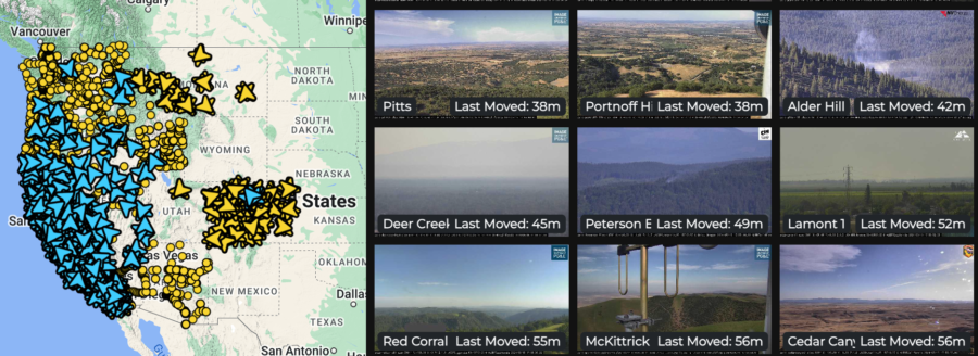
Western wildfire camera detection network

The Oregon Hazards Lab has developed and operates a high-speed camera network that gives fire managers new ways to detect and track wildfires. Cameras are installed atop high peaks or even high-rise buildings with 360-degree views of the surrounding area. Each camera can zoom, rotate, and tilt, allowing users to monitor the landscape, smokes, fire behavior, and weather conditions in real-time, or review later through time-lapse footage. The Oregon camera network is integrated with those operated by collaborators including the University of Nevada in Reno and the University of California at San Diego, with dozens of cameras in Oregon and thousands in the Western states.

The Oregon Hazards Lab network at the University of Oregon has helped put together the largest public-facing camera system in the world.

Doug Toomey, the lab’s director, says, “The cameras are visible during the day, and you can see twenty to forty miles on a clear day. At night they go near infrared, and you can actually see much farther.”

He told KEZI that detecting smoke on the cameras is only the first step. “There’s an operations center where they’re alerted when this camera spots something.”

There are currently 45 wildfire cameras in Oregon, and the Lab plans to operate 75 across the state by late 2025.  These cameras help fire managers:

        • Detect, locate, and confirm ignitions
        • Quickly scale resources up or down
        • Monitor fire behavior from ignition to containment
        • Improve local evacuations and situational awareness

The increased situational awareness available with the cameras means fire managers can confirm 911 calls by reviewing camera footage instead of dispatching personnel or aircraft for reconnaissance. Not only is this safer and less expensive, but it frees up resources that may be needed elsewhere. Fire managers can also monitor prescribed fires, and utility companies can monitor their resources during red flag conditions.

Diane Braun, a former hotshot, said she thinks the cameras would have been a valuable resource when she was on the fireline. “It would have changed the industry,” she says, “from start to finish.” Toomey adds that the cameras play a role before a fire even starts; he says the cameras help to evaluate fuels and weather conditions in the area, including winds, humidity, and other factors before fire crews even arrive.

ALERTWest cameras live feed

The network lets people monitor cameras online. Toomey said he thinks the system can help people watch fire conditions and understand the threats — and even take steps in wildfire prevention. Agencies including the Oregon Department of Forestry have access to the camera system. Jessica Neujahr with ODF said using the cameras helps them not only detect smoke, but also dispatch resources faster and get a preview of the landscape they’re heading into.

==>  WATCH LIVE CAMERA FEEDS HERE  <==

The detection cameras are powered by ALERTWest, a technology platform from DigitalPath. This platform uses artificial intelligence to enable rapid wildfire detection. AI technology pulls the camera feeds from cloud servers and scans images for ignitions using detection algorithms and then can alert dispatch centers. Dispatchers then confirm the detection before alerting responding agencies. Fire managers in Oregon will begin receiving the automated alerts during the 2024 season.

Hugh ‘Hurricane’ Carson moves on to the next place


Hugh Carson
Hugh Carson

Tailwinds and blue skies are toasted today in the direction of another longtime Fire Aviation personality, Hugh Carson, who was an Air Operations Branch Director and served as the  BLM’s State Aviation Manager for Utah and Nevada. Carson, who died recently, was also the Aviation Training Developer for the BLM at NIFC, and was famous for ordering ping pong balls delivered in quantity to fire camps in the West.

Hugh Carson
from KVNF on facebook

Hugh Carson was possibly more famous for his personality than he was for his career oeuvre — the Interagency Helicopter Operations Guide (IHOG). In retirement he was also a popular DJ with KVNF Mountain Grown Public Radio out of Paonia, Colorado, and left countless music listening fans saddened by his loss.

https://fireaviation.com/2013/01/30/12-questions-for-hugh-carson

Bill Gabbert back in 2013 ran one of his series of “12 Questions” profiles on Carson, who was instrumental in developing the Interagency Airspace Coordination Guide [PDF] — working on a related project in 1999 was when I first ran onto Hugh, who explained to me why he was known as “Hurricane.”

He’ll surely be missed.


Oregon State research team pursuing “burn to learn”

Fire science researchers at Oregon State University launched  a new project on May 10 to study how embers from homes and other buildings spread to nearby structures. “Our motto is burn to learn,” said OSU full-time research assistant Adarsh Verma. “So we are burning stuff to learn more about fire and how it’s going to spread.”

From May 10 to 16, the research team will burn outbuildings in a field and  examine the effects that structures of different sizes have on the firebrands — the embers and coals produced by a fire. They’ll analyze the numbers of embers produced, the distances they’re lofted on the breeze, and embers’ potential for new starts on adjacent buildings or other fuels.

Research assistant Jonathan Carter told Albert James with KEZI-TV that researchers are tracking the number of embers generated by flames and how hot embers get. Firebrands must hit a minimum temperature before ignition occurs in adjacent fuels.

Undergraduate research assistant Jonathan Carter and research faculty member Deepak Sharma on the faculty carry a water barrel at the test site.
Undergraduate research assistant Jonathan Carter and research faculty member Deepak Sharma on the faculty carry a water barrel at the test site. Photo from video ©Albert James / KEZI
Burning shed close
Flames rip through the 6-foot shed. Photo from video ©Albert James / KEZI.
The project kicked off on Friday, and the research team members hope to learn from the experience for future planning. “As we increase the size of the structure, the number of embers and their spread will increase,” Sharma said. “They will spread over larger areas and the number of firebrands will increase.” He said their results could guide structure design in residential areas. He hopes to look into additional factors that could affect fire behavior, including wind and home building materials.

The KEZI broadcast with Albert’s video is online [HERE].

Fire science researchers at Oregon State University launched  a new project on May 10 to study how embers from homes and other buildings spread to nearby structures. “Our motto is burn to learn,” said OSU full-time research assistant Adarsh Verma. “So we are burning stuff to learn more about fire and how it’s going to spread.”

San Diego County training drill

Ryan Grothe captured for us several terrific photos of a San Diego County wildland drill between April 30 and May 2 in Chula Vista. Several fire and law enforcement agencies participated and training included shelter deployments, structure protection, wildland hose lays, and radio communications.

A San Diego Fire-Rescue helicopter made numerous water drops, along with a few simulated hoist rescues.

San Diego Fire Rescue operates a Sikorsky 70i Firehawk. Photo ©2024 Ryan Grothe

This event is held annually;. San Diego Fire Rescue operates a Sikorsky 70i Firehawk and they have recently purchased a Bell 412 EPX, expected to be delivered sometime toward the end of this year. Once it arrives, the new Bell will go to Hangar One at Palomar Airport for installation of avionics.

San Diego Fire Rescue operates a Sikorsky 70i Firehawk. Photo ©2024 Ryan Grothe

MANY THANKS for the terrific photos, Ryan!

Ravalli County smokejumper aircraft incident

On April 22 at the Hamilton airport south of Missoula a Short Sherpa smokejumper plane — Jumper 63 or N163Z incurred “substantial” damage on landing after a training flight from MSO down to Ravalli County.

The Forest Service acknowledges the incident happened, but not in those words. They don’t want to talk about it beyond saying “we can’t talk about it.” If there’s any kind of an incident with F&AM aircraft that triggers an NTSB investigation, then the USFS can’t talk to us (the public and firefighters and fire aviation readers and media enemies) because the ONLY people who can speak about this incident are those with the NTSB. And they’re not readily available. (05/11: It’s been 16 days and zero replies from them to either of my emails.)

The Forest Service definitely can’t tell reporters and editors what’s up with an aircraft incident when the NTSB takes over. They can’t talk about the timeline, the personnel involved, the causes or results of the incident, or anything at all related to the incident. We didn’t ask for any of that.

Is that an expired registration or not an expired registration?

But they also can’t confirm whether the aircraft registration was current if you point out to them that some records online indicate that registration was lapsed back in September, and they won’t say who’s responsible for updating the registration or records thereof. (One helpful person told me the N-number is current.)

FlightAware.com photo of N163Z
FlightAware.com photo of N163Z.

We’re not talking about a multiple-fatality incident on a fire here. The smokejumper aircraft for some reason exited the runway (depending on who you talk to, the brakes may or may not have seized up or frozen up, and the aircraft may have “lost control” (though it’s probabably a pilot who loses contraol, not the aircraft), and then it “veered” off the runway. Persons who were involved or knowledgeable about the incident but who prefer to not share their names in public say that brakes on a Sherpa on landing do not “freeze up” without pilot involvement, the plane did not lose control, and “veering” from the runway likely wouldn’t cause “substantial” damage — which a couple of non-NTSB reports say it did.

This was a training flight with a Sherpa jump ship in late April; the aircraft left MSO mid-day and flew around on a training run with a pilot and two passengers and then had some kind of “incident” when it landed at Hamilton (KHRF).

The USFS has more than a couple of Short Sherpas registered for smokejumper and other purposes.

Sherpas

According to the FAA Aviation Safety Information Analysis and Sharing (ASIAS), substantial damage was incurred in an incident in which “BRAKES LOCKED AND LOST CONTROL, VEERING OFF THE RUNWAY at HAMILTON.” On the next day, the Helena FSDO was in charge. The FSDO (the Flight Standards District Office of the FAA) includes three groups — Operations and Airworthiness and Avionics — each of which has inspectors to run investigations. We’re betting the first report info will come from someone besides U.S. Forest Service employees, NINE of whom refused to even acknowledge this aircraft incident occurred.

“Autonomous” helicopter shows off possible wildfire response

Sikorsky’s “Optionally Piloted” Black Hawk helicopter equipped with MATRIX and Rain autonomy systems during fire localization and targeting demos at Sikorsky HQ in Stratford, Connecticut.
Photo couresy of RAIN.aero

Rain.aero, a developer of aerial “wildfire containment technology” along with Sikorsky, have been for some time now researching wildfire suppression autonomous response possibilities. The companies completed test flights over a year ago with an “autonomous helicopter” that can carry and drop water onto wildfires in early stages of initial attack.


Rain — and Sikorsky — demonstrate early detection and fast response to wildfires, with an autonomous Black Hawk helicopter. The two companies have completed flight tests demonstrating how a helicopter flying with Sikorsky MATRIX and Rain’s “Wildfire Mission Autonomy System” could be quickly launched for initial attack.

The flight demonstration was at Sikorsky headquarters in Stratford, Connecticut, with the “Optionally Piloted Black Hawk helicopter” flying in autonomous mode with Sikorsky safety pilots on board.

Maxwell Brodie
Maxwell Brodie

“In 2023, in collaboration with Sikorsky, we set out to prove that we could receive an alert about a possible wildfire, send commands to launch and fly an autonomous helicopter capable of moving a large amount of suppressant to a fire’s location, and then command the helicopter to accurately drop water onto the fire,” said Rain CEO Maxwell Brodie. “We are very pleased with the results that successfully demonstrate autonomous early detection and rapid response.”


What do you think about these developments? Are you a helicopter pilot, or helitack, or hotshot or other ground crew member, or lead plane pilot or ATGS ?

I don’t know enough about the air show environment to have a first-hand opinion on pilot-free helicopters in any role on any fire. I first off can’t imagine where the pilot-free RC helicopters might even be sited (on public land? Large ranches checkerboarded with BLM 40s? Western states private timber holdings? federal or state agency land? Wilderness areas?) and how vandalism possibilities likelihoods (let alone pilot-skill vandals or cyberhacked outside operators) for pre-positioned rotorcraft of any kind (let alone a Sikorsky) might be mitigated or prevented or acted upon …

Your thoughts?

Mann Gulch 75th

  This summer the Forest Service, Montana Discovery Foundation, and the National Smokejumper Association will honor those who died on the 1949 Mann Gulch Fire near the Gates of the Mountains Wilderness north of Helena, Montana.

Mann Gulch 75

 On August 5, 1949, the fire in Mann Gulch overran 15 smokejumpers and a fire guard. Thirteen of them died, memorialized for history in the book  Young Men and Fire, a classic by author Norman Maclean that won the National Book Critics Circle Award for nonfiction in 1992.
Anniversary poster art by David Goodson, provided courtesy of Montana Discovery Foundation.
Mann Gulch investigators
… and a related p.s. from facebook:
Miss Montana pilot -- blue skies

Nostalgia: DC-3 photos from Rick Freimuth

Here’s a treat:  some eye candy of DC-3 aircraft along with a bonus shot of a couple Clippers in Hong Kong sent to us today from Rick Freimuth, who says, “The first one is a slide my father took in  1948 of Victoria Harbor, Hong Kong. Look to the lower right and you can see two Clippers which could be Boeing or Martin Flying boats in the harbor.”

The rest of the photos are from a fire Rick was on in October 1979, the Norton Ridge Fire camp at Indian Creek Guard Station on the the Middle Fork of the Salmon.  The small strip was so busy with the airshow they called it Indian Creek International Airport.
October 1979, the Norton Ridge Fire camp at Indian Creek Guard Station
There were at least two USFS DC-3s, a couple of contracted Twin Otters, a Beaver, Cessnas, a couple of 212s, a 205 and a 206, an Aérospatiale Alouette III and a Lama! The DC-3s still had radial engines then, just after the fatal DC-3 crash in June 1979 in the Selway River, when a right engine fell off.  Ten souls were lost in that incident.
Oddly enough a backpacker saw the engine fall and took a photo of the plane.  Soon after that all USFS DC-3s for passenger use were grounded.
October 1979, the Norton Ridge Fire camp at Indian Creek Guard Station
“The turbine engine installations followed soon after,” says Freimuth. “I was in one of the last non-jumper flights that summer.  We flew from Challis, Idaho to SLC with a 20-person crew for a fire in the Uintas.”
October 1979, the Norton Ridge Fire camp at Indian Creek Guard Station
The Indian Creek Guard Station fire camp was a staging area for the huge spike camp about 20 miles away on a ridge near the fire. The spike camp served about six crews. After a couple of days we had everything a typical main fire camp had — showers, tool sharpening area, an aid station. It was a very late-season fire for those days, and we got emergency demobed because of snow.  I have shots of the camp from flying into it with cargo chutes hanging in the trees, chow line, camp hootches, and helo pics. I also have a shot of a 212 dropping a belly tank load of water into a portatank,  which ultimately destroyed the tank. Crazy stuff in those days.  There was also a woman on the fire who was a nationally ranked wrist wrestler.  She was entered into the national event in Las Vegas and she was flown out to attend it.  Go figure!
Camp crew gathering to unload the plane

Camp crew gathering to unload the plane
De Havilland Twin Otter landing at Indian Creek. Look at all the red tape around bottom of the door!

De Havilland Twin Otter landing at Indian Creek. Look at all the red tape around bottom of the door!
De Havilland Beaver, October 1979, the Norton Ridge Fire camp at Indian Creek Guard Station on the the Middle Fork of the Salmon.
De Havilland Beaver hauling avgas in 55-gallon barrels to the airstrip. October 1979, the Norton Ridge Fire camp at Indian Creek Guard Station on the the Middle Fork of the Salmon.

THANK YOU RICK, for the great photos and the background on these aircraft. Much appreciated!