Outlook for October — high wildfire potential for much of the West

The fire forecast through January has been released

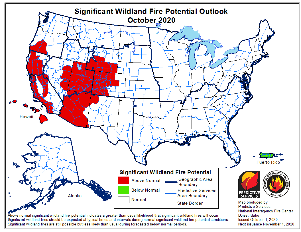
wildfire potential for October, 2020

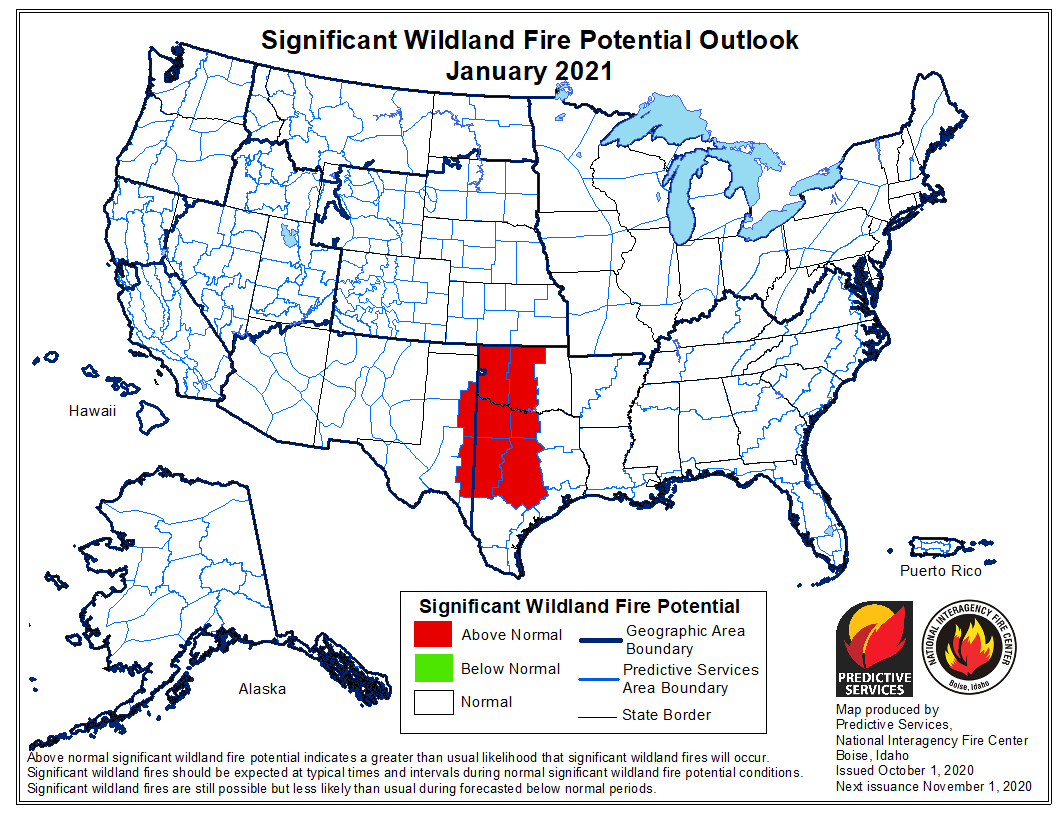
The National Significant Wildland Fire Potential Outlook issued October 1 by the Predictive Services section at the National Interagency Fire Center predicts higher than average wildfire potential in October for portions of Oregon, Wyoming, Colorado, Arizona, Nevada, and most of California.

The data from NIFC shown here represents the cumulative forecasts of the ten Geographic Area Predictive Services Units and the National Predictive Services Unit.

Below:

  • An excerpt from the NIFC narrative report for the next several months;
  • More of NIFC’s monthly graphical outlooks;
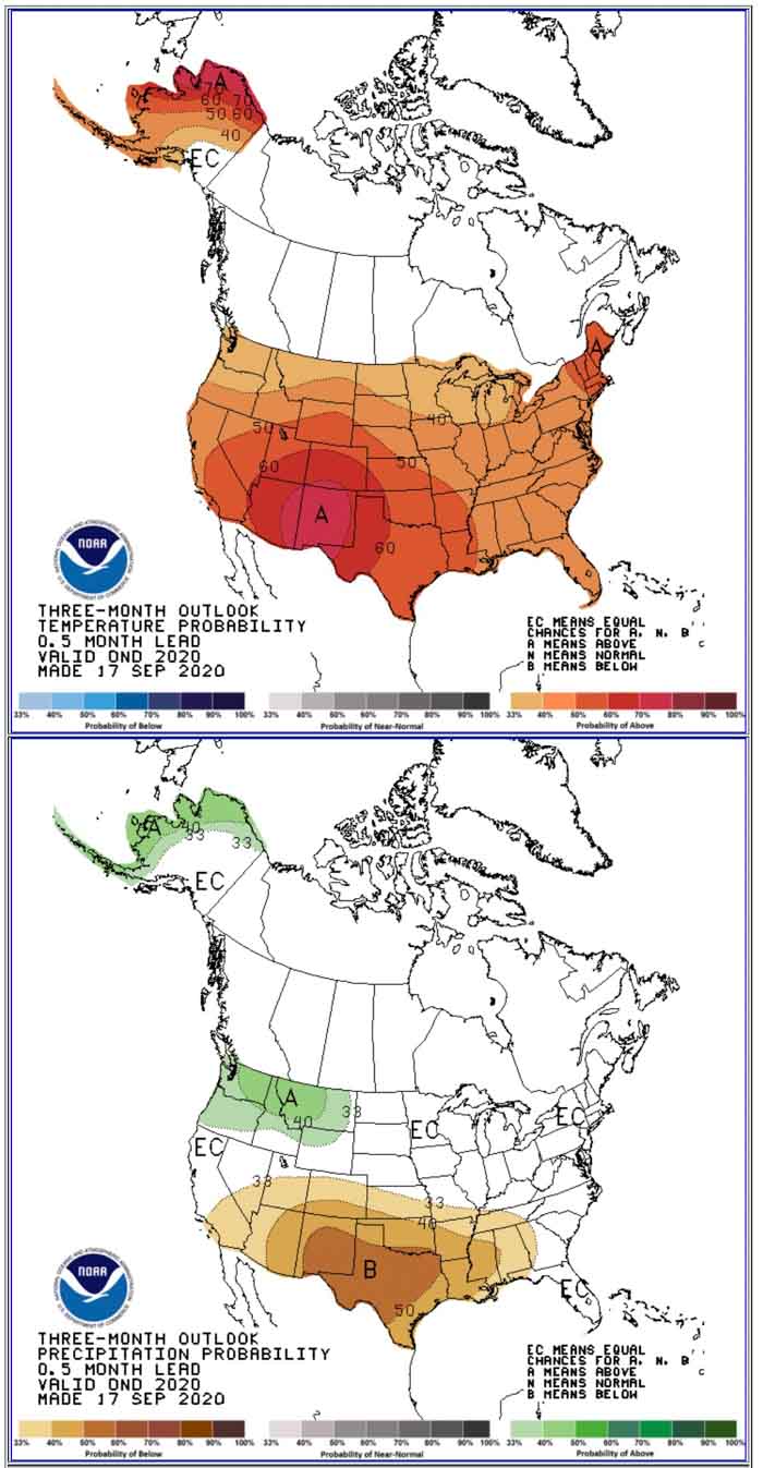
  • NOAA’s three-month temperature and precipitation forecasts;
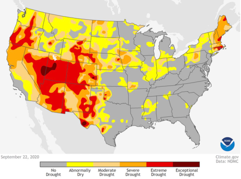
  • Drought Monitor;
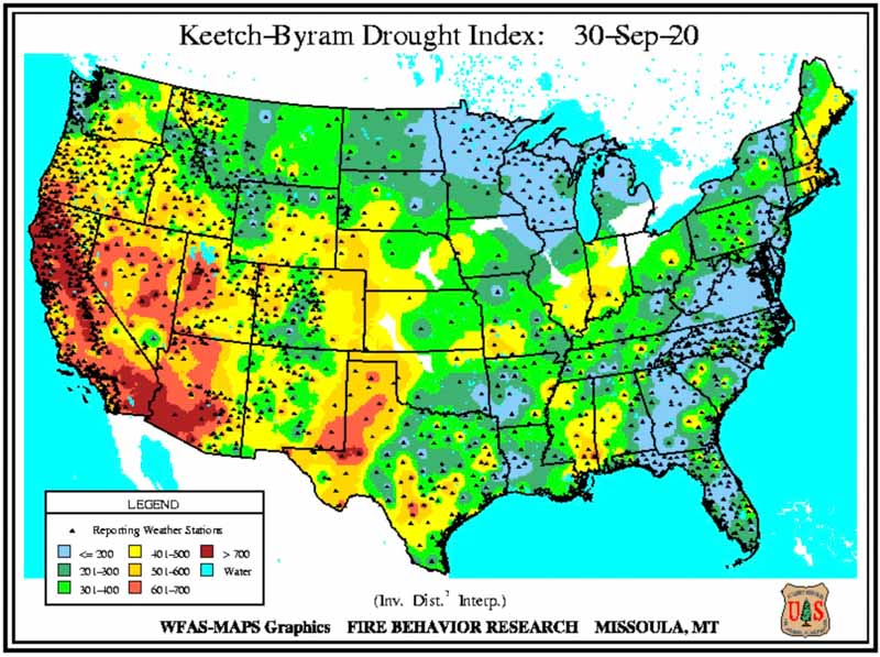
  • Keetch-Byram Drought Index.

“La Niña and current fuel conditions are the main drivers of significant fire potential through fall and into winter. Drought conditions are expected to continue for much of California, the Great Basin, and the Southwest through October with drying expected to increase across portions of the southern Plains and Southeast. Significant fire potential remains above normal for California due to the number of active large fires, near record dry fuels, and offshore wind events.

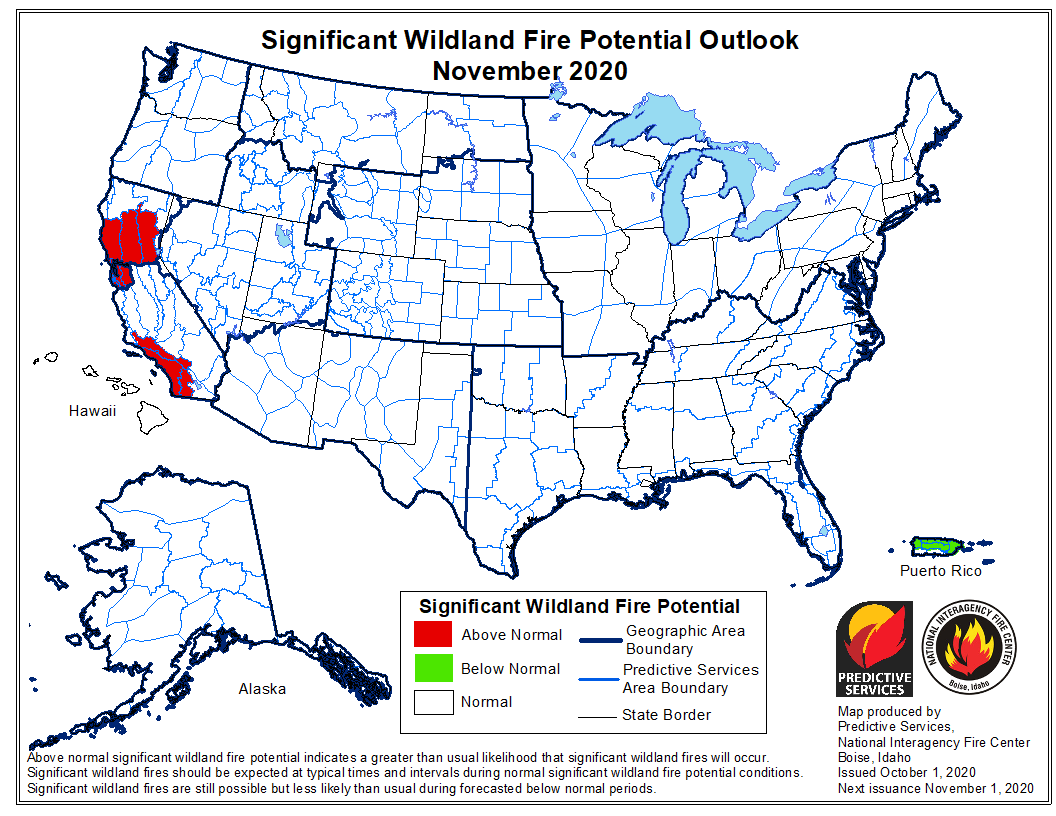
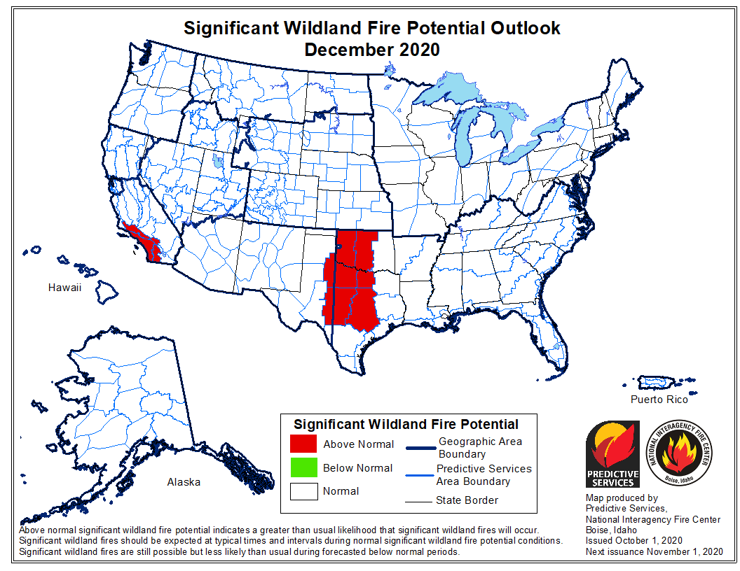
“Above normal significant fire potential is expected across much of California, Arizona, eastern Nevada, Utah, Colorado Rockies, and southern Wyoming in October. However, fire activity and potential will likely diminish across the West, except for portions of California, and remain normal over the Eastern and Southern Areas through November. Elevated periods of fire activity are likely in portions of Oklahoma and Texas and possibly in other locations in the Southern Area during fall into winter.”
wildfire potential for November, 2020 wildfire potential for December, 2020 wildfire potential for January, 2021

90-day temperature and precipitation outlook
90-day temperature and precipitation outlook, October – December, 2020.
Drought Monitor, prepared September 22, 2020
Keetch-Byram Drought Index
Keetch-Byram Drought Index, prepared Sept. 30, 2020

Zogg Fire mapped at 55,303 acres

A fourth person has been killed

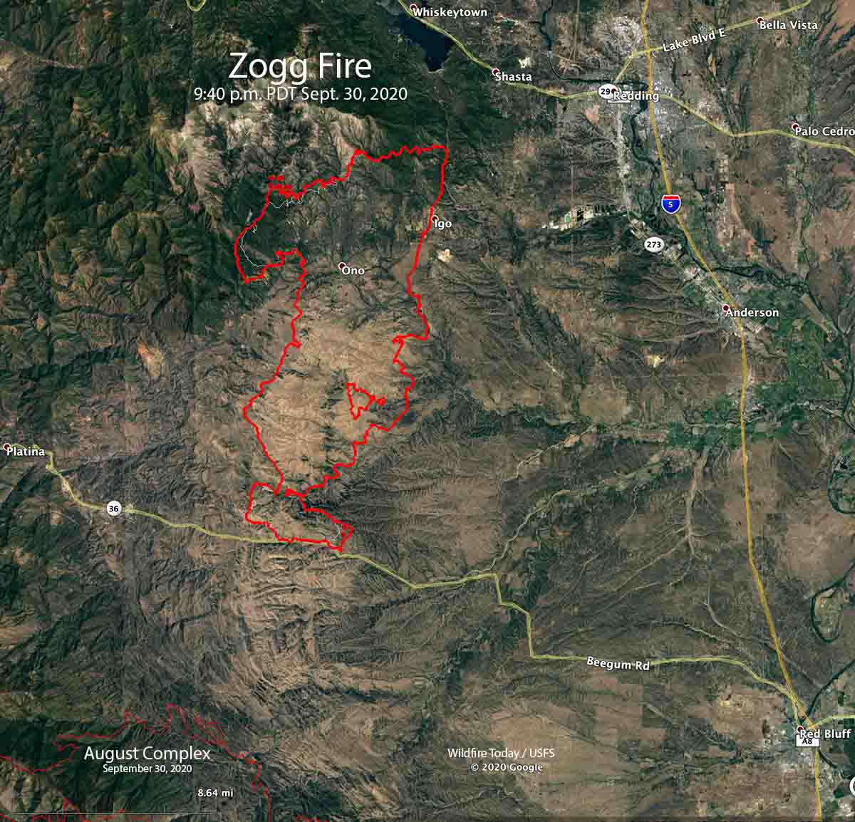
Map of the Zogg Fire
Map of the Zogg Fire. The red line was the perimeter at 9:30 p.m. PDT Sept. 30, 2020. The white line was the perimeter about 24 hours before.

Four people have died and 74 residences plus 73 other structures have been destroyed in the Zogg Fire southwest of Redding, California. The fourth fatality was announced by fire officials Wednesday. A person was found badly burned and was pronounced dead after being transported to a hospital.

CAL FIRE said Thursday morning the blaze has burned 55,303 acres.

The fire was not as active Wednesday has it had been in recent days. Most of the spread was on the northwest and southeast sides. Crews completed firing operations along critical sections of the fireline. Live fuel moistures in the area are at a very low critical level, about 60 percent, and the 1000-hour time lag dead fuel moistures are 7 percent. The lower the fuel moisture, the faster a fire spreads. Kiln-dried lumber is usually at about 12 percent.

To see all articles on Wildfire Today about the Zogg Fire, including the most recent, click here.

The weather forecast for the Zogg Fire Thursday calls for 100 degrees, 6 to 9 mph winds out of the northwest in the morning switching to northeast in the afternoon, with 7 percent relative humidity.

The dry fuels with the hot and dry forecast has led to a fire behavior forecast if there is a slopover or spot fire, for rates of spread of around 1 mph and a spotting distance of up to half a mile.

Resources assigned include 133 fire engines, 52 water tenders, 13 helicopters, 31 hand crews, and 37 dozers for a total of 1,538 personnel.

Report released for fatal crash of C-130 air tanker in Australia

September 25, 2020  |  5:23 p.m. MDT

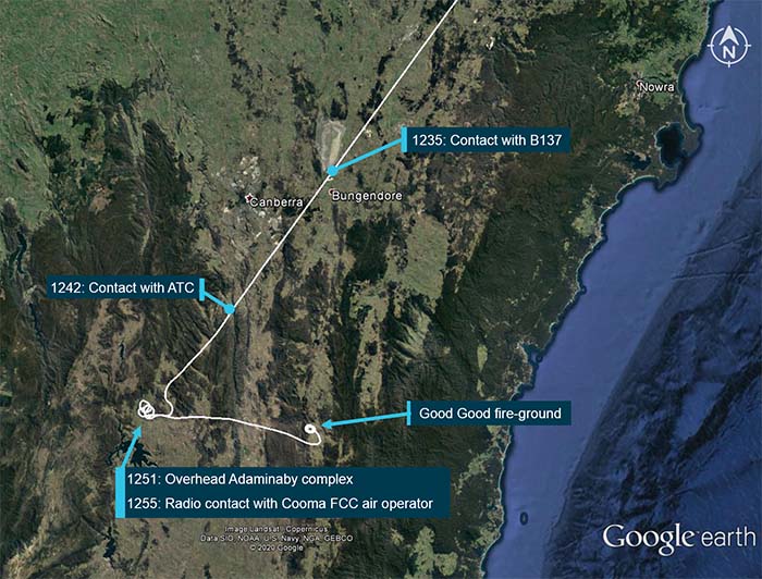
Flight path B134 air tanker crash

This article was first published at Fire Aviation September 24, 2020

The Australian Transport Safety Bureau (ATSB) has released an interim report about the January 23, 2020 crash of a C-130, Air Tanker 134, that killed the three crewmembers on board. This follows the preliminary report the agency issued in February, 2020. The aircraft was known as Bomber 134 (B134) in Australia.

“The interim report does not contain findings nor identify safety issues, which will be contained in the final report. However, it does detail the extensive evidence gathered to date, which has helped ATSB investigators develop a detailed picture of this tragic accident’s sequence of events,” said ATSB Chief Commissioner Greg Hood.

Tanker 134 at Medford, Oregon
Tanker 134 (B134) at Medford, Oregon July 27, 2019. Photo by Tim Crippin.

It was very windy on January 23, with a forecast for the possibility of mountain waves. Before the incident a birddog, similar to a lead plane, and  Bomber 137 (B137), formerly Tanker 138, a Boeing 737 that Coulson sold to New South Wales, was tasked to drop on a fire in the Adaminaby area. Based on the weather the birddog pilot declined the assignment. After B137 made a drop on the fire, the crew reported having experienced uncommanded aircraft rolls up to 45° angle of bank (due to wind) and a windshear warning from the aircraft on‑board systems.

After completing the drop, the B137 crew sent a text message to the birddog pilot indicating that the conditions were “horrible down there. Don’t send anybody and we’re not going back.” They also reported to the Cooma FCC that the conditions were unsuitable for firebombing operations. During B137’s return flight to Richmond, the Richmond air base manager requested that they reload the aircraft in Canberra and return to Adaminaby. The Pilot in Command (PIC) replied that they would not be returning to Adaminaby due to the weather conditions.

B134 was dispatched to the fire at Adaminaby. While they were in route, the PIC of B137 called to inform them of the actual conditions, and that B137 would not be returning to Adaminaby.

After arriving at Adaminaby the PIC of B134 contacted the air operations officer at the Cooma FCC by radio and advised them that it was too smoky and windy to complete a retardant drop at that location. The Cooma air operations officer then provided the crew with the location of the Good Good Fire, about 58 km to the east of Adaminaby, with the objective of conducting structure and property protection near Peak View. Again, there was no birddog operating with the air tanker.

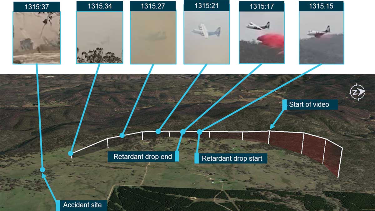
B134 flight path air tanker crash
Flight path overview (in white), including the times and locations of where the crew of B134 was in communication with others. From the report.

Analysis of a witness video confirmed that the aircraft initially established a positive rate of climb and was banking to the left following the retardant drop, the report details. Continue reading “Report released for fatal crash of C-130 air tanker in Australia”

Meteorologists determine the Creek Fire created two fire tornados

Northeast of Fresno, California earlier this month

Satellite photo showing smoke from fires in California
Satellite photo showing smoke from fires in California at 6:01 p.m. PDT Sept 5, 2020. NASA/Wildfire Today. The Creek Fire

The Creek Fire ran for more than 10 miles and burned 36,000 acres during the first 22 hours after it started at 6 p.m. September 4 northeast of Fresno, California. During that time it created two fire tornados and sent its smoke plume up to 55,000 feet, taller than the tornadic thunderstorms in tornado alley.

An analysis by meteorologists from the National Weather service has revealed that the extreme growth on September 5 generated rare phenomenons — vortices rated at EF2 and EF1, sometimes called fire tornados when they are created by a wildfire.

One was near Mammoth Pool Reservoir and the other was near Huntington Lake. Over 200 people trapped by the fire at Mammoth Pool Reservoir were flown out by courageous National Guard Pilots in helicopters, at times through darkness and smoke.

The NWS personnel rated the vortices based on the effects on trees, including areas where trees were debarked, indicating an EF2 event.

Below is an excerpt from an article by Matthew Cappucci  in the Washington Post.

Jerald Meadows, the warning coordination meteorologist at the Hanford office, said both tornadoes shared common features. “The main contributing factor was the debarking of all the pine trees up with the Mammoth Pool tornado,” Meadows said. “They both uprooted trees to the root balls and snapped large pines. But the [EF1 tornado] did not have any signs of true debarking. We’re probably talking the difference between 100 and 110 miles per hour.”

The Mammoth Pool tornado, which touched down inside the Wagner Campground, snapped several two-foot-diameter trees about 20 to 30 feet above the ground; it was rated as having winds of 115 to 125 mph. The Huntington Lake fire tornado had winds of 90 to 107 mph, and the NWS noted that it was “the result of unprecedented fire activity.”

The article reports that the NWS personnel on duty while the tornados were occurring had concerns about activating their severe weather warning system.

“A tornado warning was considered but not issued,” said [Jerald Meadows, the warning coordination meteorologist at the Hanford Office], who feared that disseminating such an alert might leave people unnecessarily conflicted about deciding whether to shelter or evacuate.

“A tornado warning for a fire opens up a can of worms,” he said. “We want to make sure we’re messaging properly, and we were talking to fire crews letting them know of the circulations we were seeing.”

Before the onslaught of fire tornadoes that has been a hallmark of 2020′s blazes, some National Weather Service offices have had internal discussions and concluded that they would not issue tornado warnings for wildfire-related twisters. While the National Weather Service hasn’t issued specific policy guidance to its 122 forecast offices on how to handle fire tornadoes, Meadows suspects considerable research will be needed to reach a resolution.


This article was edited September 26 to clarify the locations of the fire tornados at Mammoth Pool Reservoir and Huntington Lake.

Thanks and a tip of the hat go out to Tom.