After a couple of days of decreasing wildfire smoke from Canada, on Tuesday the United States midwest is seeing heavier concentrations of the pollutant generated by fires in Alberta.
News and opinion about wildland fire
 Firefighters, heavy equipment, and aircraft continue to work on the McMillan Complex in Alberta which is approximately 22km northeast of the junction of Highway 88 and Highway 754. The complex is comprised of 4 wildfires that are a combined 215,065 hectares (531,439 acres) in size. Alberta Fire photo.
At least five hotshot crews from Oregon and Montana will be leaving Wednesday to assist with the wildfires in Alberta.
Kathy Bushnell of the Helena-Lewis and Clark National Forest said Montana hotshot crews from the Helena, Lolo, Bitterroot and Flathead national forests will travel north with the Rogue River Hotshots from Oregon.
Deb Schweizer of the USFS office in Boise told Wildfire Today that an additional 15 personnel are being mobilized for a variety of overhead positions.
Thanks and a tip of the hat go out to Tom. Typos or errors, report them HERE.

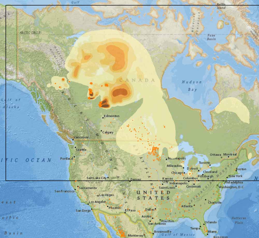
Smoke from wildfires in Alberta is still detectable across most of the Eastern United States today, but the Canadian government’s smoke forecast expects a significant decrease throughout the lower 48 states on Monday.
Cooler weather along with a slight chance of showers off and on in Alberta over the last several days has slowed the progress of the wildfires, including the 230,000-hectare (568,000-acre) Chuckegg Creek Fire at the town of High Level. Those conditions are expected to continue during this week, so it appears that U.S. residents will get a respite from polluted air that at times has been very unpleasant in the Northwest, especially along the Canadian border in Montana and Idaho.
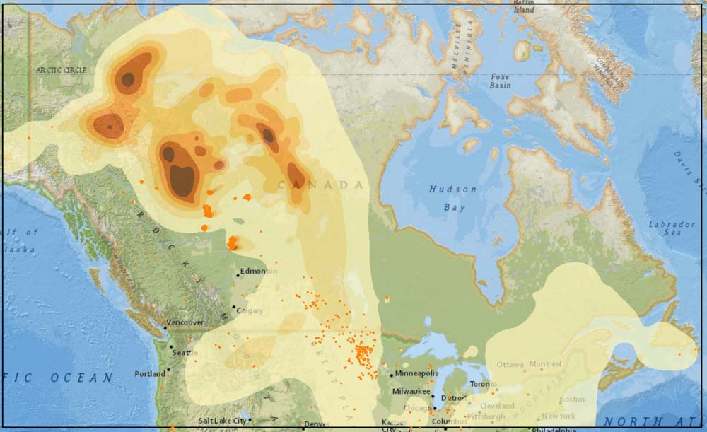
The map above represents conditions today, Sunday June 2. The map below is the Canadian government’s forecast for smoke tomorrow, June 3. The Canadian system does not predict smoke conditions in the south half of the U.S. (outside of the box with the black lines).

Areas to watch will be Northern California and the west sides of Oregon and Washington
On June 1 the Predictive Services section at the National Interagency Fire Center issued their Wildland Fire Potential Outlook for June through September. The data represents the cumulative forecasts of the ten Geographic Area Predictive Services Units and the National Predictive Services Unit.
If NIFC’s analysis is correct, the areas with above normal wildfire potential on the western sides of Washington, Oregon, and California will expand during the four-month period until they cover most of the forested lands in California as well as northern Washington and Idaho. Forecasters predict portions of Florida, Georgia, and the Carolinas will have enhanced potential in June and July.
The areas affected by the multi-year drought in the West have greatly decreased to the point where there are no locations with extreme or exceptional drought. Northwestern Oregon is classified as “severe drought” and this could be an area to watch over the summer months.
Below:
From NIFC:
“…As June progresses, the fine fuels will begin to cure and dry from south to north across the West. Lingering high elevation snowpack should be lost. Wildfire activity should begin to increase by late month as peak of the fire season begins to arrive as July and August approach. As is the case with the lower elevation fuels, the high elevation heavy fuels will also experience a delayed entry into the season except along the Canadian Border in Washington State where overall dryness will lead to an average start with a potential for above normal activity. Alaska will reach its peak in June and begin to wind down in July.
“Looking ahead to August and September the fire potential and resulting activity should increase to Normal in most areas except along the West Coast where Above Normal significant large fire potential is expected due to fuel loading and preexisting dry conditions. A traditional winding down of the Western fire season is expected in Mid-September as fall moisture begins to arrive…”

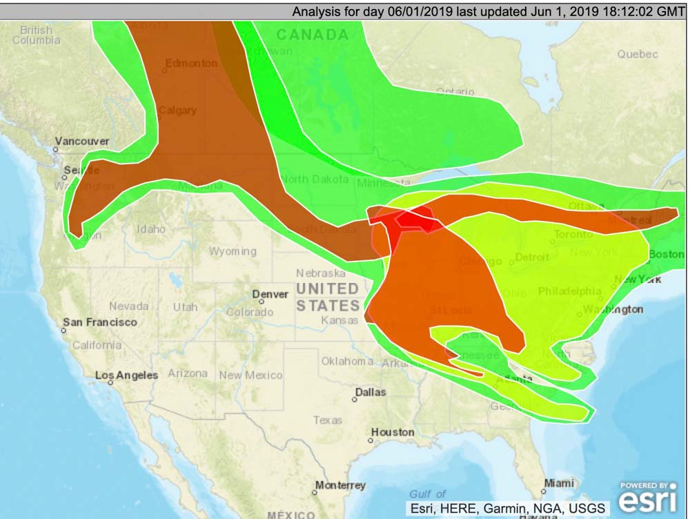
On Saturday smoke from the wildfires in Alberta, Canada was affecting parts of Washington, Oregon, Montana, North Dakota, Missouri, Minnesota, Iowa, South Dakota, and most of the states east of the Mississippi River — plus the Canadian provinces of Alberta, Saskatchewan, and Manitoba.
Below is the smoke forecast for Sunday at noon MDT June 2, produced by the Canadian government. Unfortunately it does not include the entire U.S.

“Firefighters lives are as important as soldiers.” Bill Gabbert, 2018.

Next week there will be a fire management technology “Expo” in Washington, D.C. to introduce Senators to emerging technology that can aid wildland firefighters.
Fourteen months after it was first introduced, the Wildfire Management Technology Advancement Act became law after it was included in an omnibus bill, the Natural Resources Management Act. The Senate passed it with a vote of 92 to 8, and the House followed suit, 363 to 62. On March 12, 2019 it was signed by the President.
Now that the legislation has become Public Law 116-9 the federal land management agencies are directed to adopt or build on a number of new technologies that can enhance the safety of firefighters and aid in the suppression of wildfires.
The Expo scheduled for June 5 will give approximately eight to twelve proponents or vendors of new technology time to explain what these new systems can do. Then the Senators and their staffs will be able to individually talk with the representatives and examine the exhibits and displays the companies brought that will be lining the walls of the Senate hearing room.
Several of the technologies expected to be featured are listed below.
Later in June the Committee will convene their annual hearing where representatives of the land management agencies will bring the Senators up to date on their plans for managing wildfires this year. And importantly, the Senators, then fresh from their brief seminar on new technologies, will be able to discuss how the agencies are progressing on implementing the technology directives that they are now required by law to implement, many of which have due dates.
The key points in Public Law 116-9 have requirements for the Secretaries of Interior and Agriculture. The completion dates were established from March 12, 2019 when the legislation was signed.
In October, 2013 we first wrote about what we called the Holy Grail of Wildland Firefighter Safety. It is a system that could track in real time the location of firefighters AND the fire, all displayed on one screen. This data should be available in real time to key supervisors and decision makers in the Operations and Planning Sections on fires. Knowing the positions of personnel relative to the fire would be a massive step in improved situational awareness and could reduce the number of firefighters killed on fires. Too often firefighters have been surprised, overrun, and sometimes killed by a rapidly spreading wildfire when they did not know where the fire was and/or their supervisors did not know the correct, actual location of the personnel.
Not everyone on a fire would need to monitor the location data all the time, but at least one person should be given the responsibility to be sure that a rapidly spreading wildfire does not overrun the location of firefighting resources. Darkness, smoke, and terrain can obscure the location of the fire from firefighters on the ground.