Thomas Fire burns into Ventura, California

The fire has blackened about 45,000 acres and destroyed 150 structures.

The map above shows the approximate location of the Thomas Fire at 1:06 a.m. PST December 5, 2017 based on data from a satellite.

(UPDATED at 3:05 p.m. PST December 5, 2017)

Firefighters now estimate that the Thomas Fire which burned from Santa Paula to Ventura, California has now covered about 50,000 acres.

****

(Updated at 8:39 a.m. PST December 5, 2017. We will update this article on Tuesday as more information becomes available.)

The Thomas Fire has spread into the north side of Ventura, California, burning tens of thousands of acres. After it started Monday near Thomas Aquinas College very strong Santa Ana winds pushed it across Highway 150 close to Santa Paula and it then ran about 15 miles southwest to the edge of Ventura. About 27,000 people have been evacuated.

An update from Ventura County officials at 8 am Tuesday reported it had blackened 45,000 acres and destroyed about 150 structures. The areas of concern include Upper Ojai, Santa Paula, and Ventura.

The strong winds have made it impossible for fixed wing aircraft to fly low and slow near the ground as they have to do while dropping retardant or water. However early Tuesday morning helicopters were able to effectively work in some areas near Ventura. If the wind decreases Tuesday morning officials hope to have both types of aircraft available to assist firefighters on the ground.

Electrical outages have affected 260,000 homes and the lack of power at some water pumping facilities has left some fire hydrants dry.

Ventura County has more information about areas under evacuation orders.

(Articles on Wildfire Today about the Thomas Fire are tagged “Thomas Fire“)

Thomas Fire causes evacuations near Santa Paula, California

(UPDATED at 12:10 a.m. PST December 5, 2017)

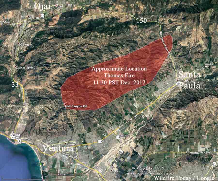
map Thomas Fire
Map showing the very rough approximate location of the Thomas Fire northeast of Ventura, California, at 11:30 p.m. PST December 4, 2017. Click to enlarge.

****

(UPDATED at 11:31 p.m. PST December 4, 2017)

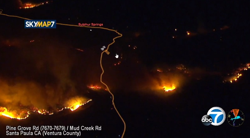
ABC7 is showing on their live video that the Thomas Fire has spread from Santa Paula, California southwest to the outskirts of Ventura. As of 10:40 p.m. PST the fire had reached Hall Canyon and Sexton Canyon Roads north of Ventura. It is moving toward Highway 33.

(For the most current information about the Thomas Fire, visit https://wildfiretoday.com/tag/thomas-fire/)

Anyone between Highways 150 and 33 or north of Foothill Road should be prepared to evacuate. Much of that area is already on fire.

The wind driven fire is launching burning embers very far ahead to the west and southwest that are starting spot fires ahead of the main fire which then grow quickly.

Our unofficial tracking shows that the fire is approximately 12 miles long. Many areas have lost electrical power, including portions of Santa Barbara.

Approximately 30 mobile homes off Wheeler Canyon Road north of Foothill Road have burned, according to ABC7.

Ventura County Fire Department estimates the Thomas Fire has burned about 10,000 acres.

****

(Originally published at 10:24 p.m. PST December 4, 2017. We will update this article as new information is available. )

A wind-driven wildfire is causing evacuations north of Santa Paula, California 8 to 10 miles northeast of Ventura. At 9:41 p.m. Monday Ventura County Fire Department officials said the fire was about 5,000 acres, and is spreading quickly. They expect it to reach the city of Ventura Monday night.


Multiple structures have burned,  but how many is unknown.

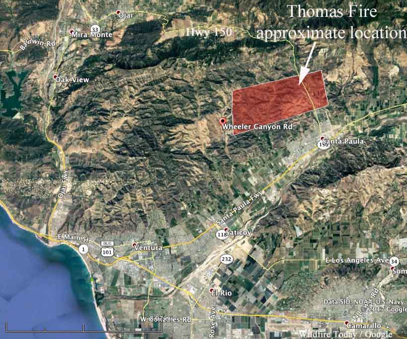
Santa Ana winds that are affecting much of the coastal and mountain areas of Southern California have pushed the fire at least five miles to the west across Highway 150 and at 9:30 p.m. PST had reached Wheeler Canyon Road where structures are reportedly burning. Portions of the fire have also reached Aliso Canyon Road.

Weather stations in the Santa Paula area recorded wind gusts of 17 to 28 mph out of the east with relative humidity of 7 to 16 percent.

We put together the following map which is very unofficial, based on live video from ABC7.

map Thomas Fire Santa Paula
General location of the Thomas Fire at 9:30 p.m. PST December 4, 2017. Wildfire Today. Click to enlarge.

The Ventura County website has details about evacuations, but occasionally the site is down, probably due to heavy web traffic.

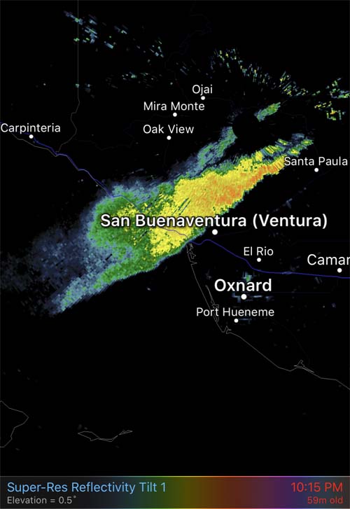
radar smoke thomas fire wildfire
Radar image showing smoke from the Thomas Fire at 9:15 PST December 4, 2017.

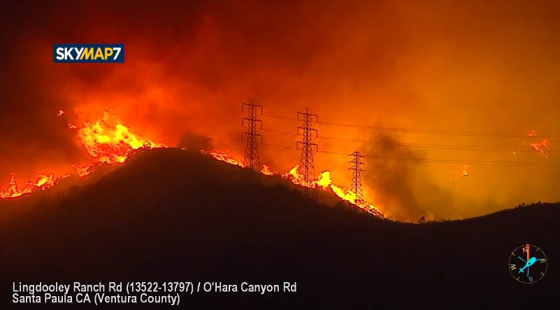
The images below are screenshots from the ABC7 live video.

Thomas Fire
Thomas Fire at 10:04 p.m. PST December 4, 2017. KTLA.
Thomas Fire
Thomas Fire at 8:59 p.m. PST December 4, 2017. The road is Highway 150 north of Santa Paula. KTLA.

Repercussions of a government prescribed fire that escapes and burns private property

In 2010 a prescribed fire on the Helena National Forest escaped and burned approximately 450 acres of private property.

Davis Fire, Aug. 26, 2010
Davis 5 Fire, Aug. 26, 2010. Photo: markholyoak

On August 26 and 27, 2010 the Davis 5 prescribed fire on the Helena National Forest in Montana escaped control 28 miles northwest of Helena. It happened on a windy day during Fire Weather Watch conditions when the temperature in Helena set a record for the highest ever recorded on that date .

(Articles on Wildfire Today tagged “Davis 5 prescribed fire”)

The project that was expected to treat 100 acres eventually burned about 1,600 acres of U.S. Forest Service land and approximately 450 acres of private property.

Today the Helena Independent Record and the Missoulian published an article written by Tim Kuglin that retells the story of the Davis 5 Fire. Mr. Kuglin concentrated on the effects on the private landowners and their battles, largely unsuccessful, to obtain reparations from the federal government.

The post-fire report commissioned by the U.S. Forest Service, as is the custom with federal land management reports about fires that have bad outcomes, did not outline many significant issues or bad decisions that led to the escape.

Davis fire
Firemen line the Stemple Pass Road August 26, 2010, on the Davis Fire. Dylan Brown photo.

Most of Kent Taylor’s 146 acres burned in the fire. After being rebuffed by the USFS he went to court to seek payment for damages. Senior U.S. District Judge Charles Lovell decided on March 22, 2015 that the U.S. is immune from the suit, writing in his decision:

The Court concludes that Plaintiff has failed to demonstrate that the Forest Service was negligent either in conducting the Davis 5 Unit prescribed burn or in fighting the escaped fire once it occurred or that the Forest Service violated any mandatory policy or prescription. In addition, and more significantly, strict liability does not apply and the discretionary function exception applies to bar Plaintiff’s tort claims.

The court decision, the official USFS report, and the recent newspaper article did not seriously consider two issues that we mentioned in 2010:

1. The first was the failure to take notice of the spot weather forecast that was issued at 10:43 a.m. Wednesday on the day of the burn, just before the firefighters ignited the test burn. That forecast predicted stronger winds than in the forecast that was issued the previous day which was for “winds upslope 3 to 6 mph, ridge top winds southwest 5 to 10 mph with gusts to 15 mph”. Here is what Wednesday morning’s forecast predicted for the day of ignition (the all-caps are from the weather forecast):

WIND (20 FT)……..SOUTHWEST WINDS 10 TO 15 MPH WITH AFTERNOON GUSTS 20 TO 25 MPH.
RIDGE TOP WIND……WEST AT 15 TO 20 MPH.

The report says:

The prescribed fire personnel stated they did not note any differences between the two forecasts.

That forecast also stated that on the following day, Thursday, the winds in the afternoon would be 30 to 35 mph.  The maximum wind speed allowed in the prescription for the project was 15 mph, which, from my experience, is quite high for a prescribed fire.

2. The second issue is the fact that they knew on Tuesday, the day before the burn began on Wednesday, that near record heat and a Fire Weather Watch with gusty southwest winds was forecast for Thursday. This Watch was upgraded to a Red Flag Warning on Wednesday afternoon after ignition had begun. Even in a best case scenario, if there had been no spot fires or other control problems on Wednesday, the 30 to 35 mph winds predicted for the day after ignition should have alerted experienced fire management personnel that the winds across the 100-acre prescribed fire could have caused embers to be blown across the lines, resulting in the fire escaping. Control would have been difficult in 30 to 35 mph winds.

Strong winds and extreme wildfire danger predicted for Southern California this week

This Santa Ana wind event will likely be the strongest and longest duration one we have seen so far this fire season. Red Flag Warnings have been issued for Sunday night through Thursday.

Above: Red Flag Warnings issued for Southern California December 3, 2017.

(Originally published at 9:31 a.m. PST December 3, 2017)

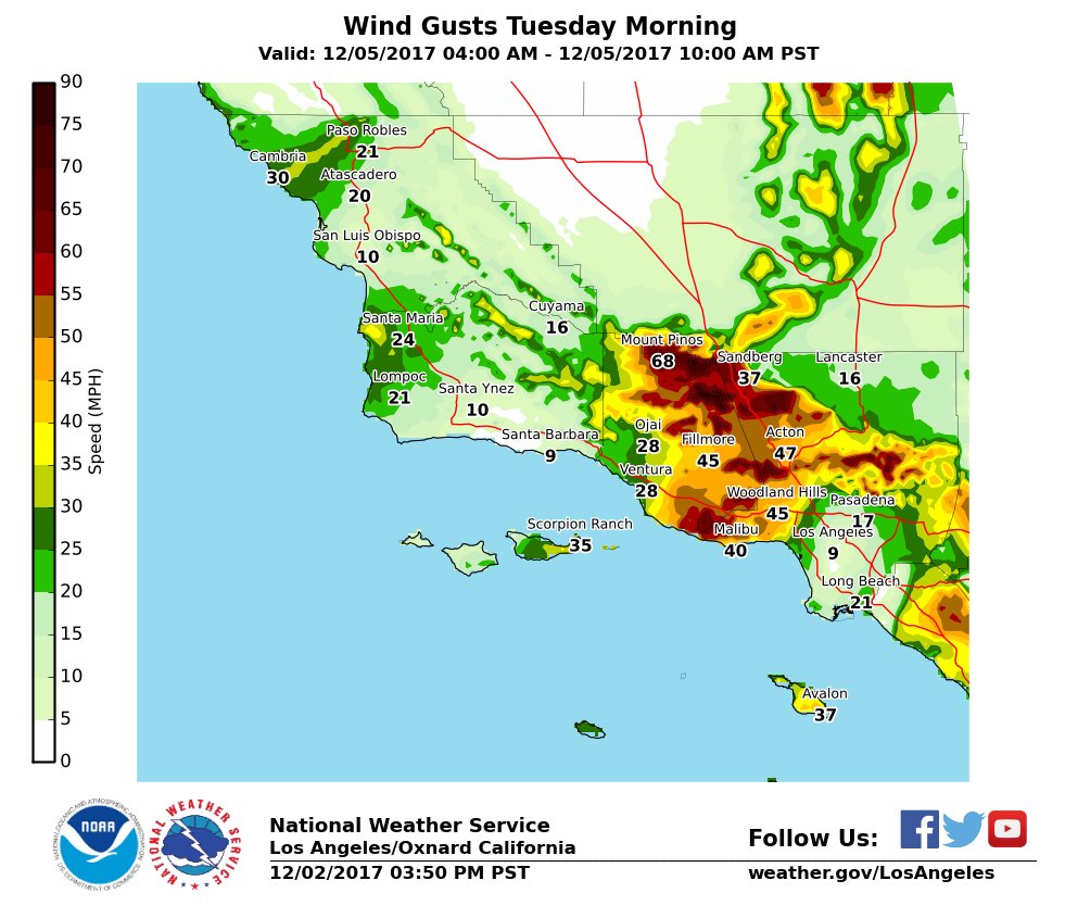
The strongest Santa Ana wind event so far this fire season is in the forecast for the coastal and mountain areas of Southern California this week. The National Weather Service has issued Red Flag Warnings for Sunday night through Thursday for areas within the counties of Santa Barbara, San Bernardino, Riverside, and San Diego.

It is unusual for a Red Flag Warning to extend over parts of five days. And this one has the possibility of being extended for an additional one or two days into the weekend.

The exact timing and speeds will vary by location, but generally, powerful winds will begin Sunday night out of the north and on Monday will be from the northeast at 25 to 40 mph with gusts of 50 to 65, reaching 80 at some peaks and exposed areas.

The NWS forecast includes this statement:

If fire ignition occurs, there will be the potential for rapid spread of wildfire with extreme fire behavior that could lead to a threat to life and property.

The strong winds and low relative humidities (5 to 15 percent)  should continue at least through Thursday. Long range computer models are showing the possibility that the Santa Ana winds could persist into Friday or Saturday, which may require the extension of the Red Flag Warnings.

Wind Gusts Tuesday california santa winds wildfire

BLM: fuel breaks stopped spread of Centennial Fire

The BLM fuel breaks are initially created by using herbicides

Above: screenshot from the BLM video showing a fuel break.

(Originally published at 10 a.m. MST December 2, 2017)

The Bureau of Land Management produced this video that explains their philosophy of creating fuel breaks in Idaho by using herbicides followed by planting fire resistant vegetation such as “Stabilizer” Siberian wheatgrass. The 2017 Centennial Fire west of Twin Falls would have grown much larger, they claim, had it not stopped at a fuel break 275 feet wide.

fuel break herbicide aerial application
An aircraft sprays herbicide on a BLM fuelbreak. Screenshot from the BLM video.

Wildfire potential, December through March

Dry offshore winds predicted for Southern California next week.

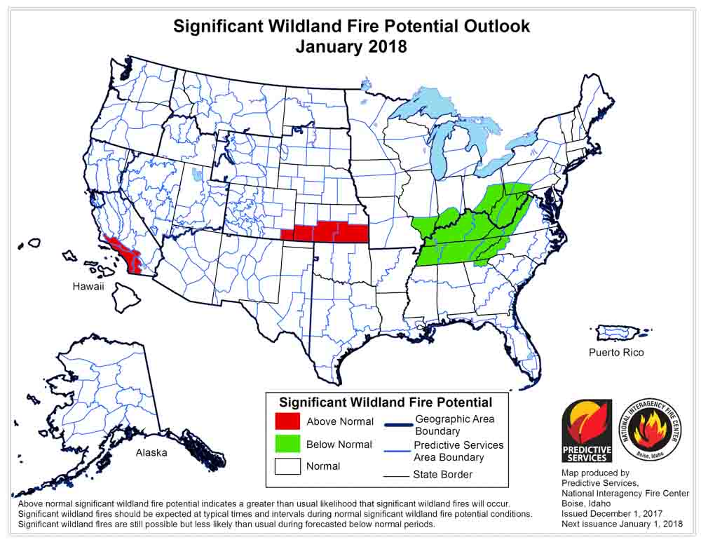
Above: wildfire potential for December, 2017.

(Originally published at 8:12 a.m. MDT December 2, 2017)

On December 1 the Predictive Services section at the National Interagency Fire Center issued their Wildland Fire Potential Outlook for December 2017 through March 2018. The data represents the cumulative forecasts of the ten Geographic Area Predictive Services Units and the National Predictive Services Unit.

If the prediction is accurate, Southern California and Southern Kansas should see higher than normal wildfire activity, with increasing potential in New Mexico, Texas, and Oklahoma in the latter part of the period.

Below are:

  • The highlights of the NIFC report;
  • NIFC’s graphical outlooks;
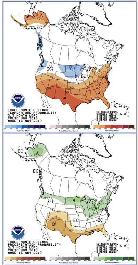
  • NOAA’s long range temperature and precipitation forecasts; and
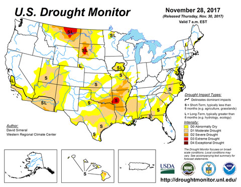
  • Drought Monitor.

“Warm and dry conditions continued across Southern California and the Southwest in November. The wind events observed across Southern California in October ended in early November. Periodic wind episodes in mid-to-late November led to slight increases in fire activity in New Mexico. In the Southeast, the autumn fire season was held in check by the passage of occasional, precipitation-bearing frontal systems that kept fire danger indices from reaching levels similar to what was observed in November 2016. Across the remainder of the country, regions were generally out of fire season as fire activity remained low.

“Temperatures across the Southwest and California were generally above average in November as high pressure off the coast of Baja California dominated. New England also experienced above average temperatures. Alaska experienced temperatures that were well above average for the first half of the month but saw a pattern shift during the middle portion of the month that allowed for below average temperatures to develop. The remainder of the country experienced near average temperatures through the month. Precipitation deficits mounted across the Southwest and Southern California as the weak La Nina-like conditions persisted. The overall dry, westerly flow across the Great Plains also allowed for pockets of drought conditions to emerge. Wetter-than-average precipitation continued across the northwestern portion of the country and across the Great Lakes region. In Alaska, precipitation was near average.

“Latest data shows that the patterns observed in November persisting through the winter months across the nation. Mountain snowpack should be at least near average except across the Southwest where below average snowpack is expected. The potential for above normal snowpack exists from the northern Sierras north to the Canadian border. An elevated potential for significant snowfall also exists across the Great Lakes region. Temperature departures should be stratified with the northern tier of the country experiencing overall colder-than-average temperatures and the southern tier of the country experiencing warmer-than-average temperatures.”

Wildfire potential January

Wildfire potential February March

temperature precipitation long range forecase

drought monitor weather