Precipitation reduces wildfire smoke in the central U.S.

Above: Snow cover in the United States, November 18, 2016. The Weather Channel.

Precipitation in the northwest quarter of the United States this week has put even more of a damper on the occurrence of wildfires, the execution of prescribed fires, and agricultural burning.

After weeks of warm, dry weather the Black Hills finally received a little precipitation over the last 24 hours. I won’t know the exact amount at my house until the snow in the rain gauge melts, but there was an inch or two of the white stuff on the ground. Today is sunny with a high of 32 predicted, so maybe it will trickle through the tipping bucket this afternoon.
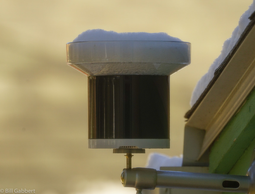
snow rain gauge
Snow captured by my rain gauge since Thursday afternoon. Photo at 11 a.m. MT November 18, 2016 by Bill Gabbert.

Small amounts of precipitation in southern Saskatchewan may be the reason smoke from that area is no longer immigrating into the United States, as you can see in the two maps below. The first one was the smoke forecast for November 15 and the one after that is for today, November 18.
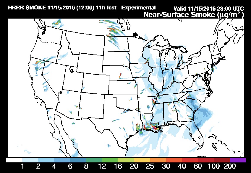
wildfire smoke forecast
Prediction for the distribution of smoke from wildfires at 6 p.m. ET, November 15, 2016. Produced at 7 a.m. ET November 15.
wildfire smoke forecast
Forecast for wildfire smoke at 6 p.m. ET November 18, 2016, created at 1 a.m. ET November 18, 2016.

However, prescribed fires, wildfires, or agricultural burning in Louisiana, Arkansas, and eastern Texas are still producing large quantities of smoke that at times moves north into the midwest.

No rain is predicted until the middle of next week for the areas where wildfires are smoking out the residents in some areas of Tennessee, North Carolina, Georgia, and South Carolina.
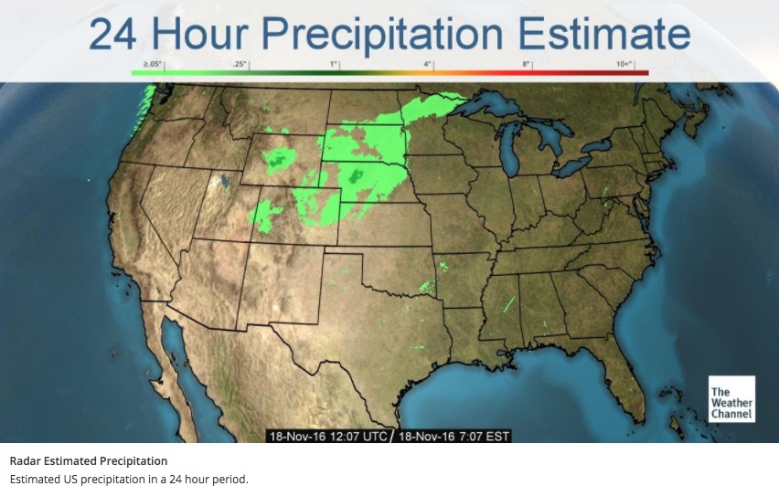
24 hour precipitation
Accumulated precipitation estimated by radar over the 24 hours before 7:07 a.m. ET November 18, 2016.


North Carolina to receive the worst of the smoke on Friday

Above: Forecast for wildfire smoke at 6 p.m. ET November 18, 2016. Created at 1 a.m. ET November 18, 2016.

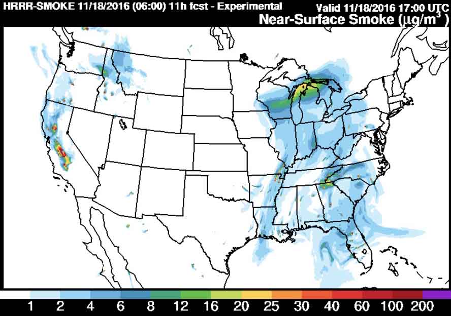
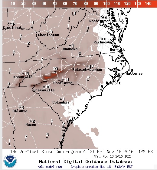
Most of the eastern one-third of the United States will be experiencing some degree of wildfire smoke on Friday. But by far the heaviest concentrations are being created by the wildfires in the South. The winds on Friday will cause the much of the smoke to pass through areas in western Tennessee, northern Georgia, and western North Carolina.

Forecast for wildfire smoke at 1 p.m. ET November 18, 2016, created at 6:30 a.m. ET November 18, 2016.

Continue reading “North Carolina to receive the worst of the smoke on Friday”

Research: Wildfires in Sierra Nevada driven by past land use

Changes in human uses of the land have had a large impact on fire activity in California’s Sierra Nevada since 1600, according to research by a University of Arizona researcher and her colleagues.

Above: Indian Canyon Fire near Edgemont, SD, 2016. Photo by Bill Gabbert.

By Mari N. Jensen, University of Arizona College of Science

Forest fire activity in California’s Sierra Nevada since 1600 has been influenced more by how humans used the land than by climate, according to new research led by University of Arizona and Penn State scientists.

For the years 1600 to 2015, the team found four periods, each lasting at least 55 years, where the frequency and extent of forest fires clearly differed from the time period before or after.

However, the shifts from one fire regime to another did not correspond to changes in temperature or moisture or other climate patterns until temperatures started rising in the 1980s.

“We were expecting to find climatic drivers,” said lead co-author Valerie Trouet, a UA associate professor of dendrochronology. “We didn’t find them.”

Instead, the team found the fire regimes corresponded to different types of human occupation and use of the land: the pre-settlement period to the Spanish colonial period; the colonial period to the California Gold Rush; the Gold Rush to the Smokey Bear/fire suppression period; and the Smokey Bear/fire suppression era to present.

“The fire regime shifts we see are linked to the land-use changes that took place at the same time,” Trouet said.

“We knew about the Smokey Bear effect — there had been a dramatic shift in the fire regime all over the Western U.S. with fire suppression. We didn’t know about these other earlier regimes,” she said. “It turns out humans — through land-use change — have been influencing and modulating fire for much longer than we anticipated.”

Continue reading “Research: Wildfires in Sierra Nevada driven by past land use”

Red Flag Warnings, November 17, 2016

The National Weather Service has posted Red Flag Warnings or Fire Weather Watches for areas in California, New Mexico, Colorado, Kansas, Oklahoma, Texas, Missouri, and Kentucky.

The map was current as of 9:45 a.m. MT on Thursday. Red Flag Warnings can change throughout the day as the National Weather Service offices around the country update and revise their forecasts and maps.

Wildfire smoke forecast for November 17, 2016

Above: In this satellite photo taken during the afternoon of November 16, smoke from wildfires is clearly visible in Georgia, North Carolina, and South Carolina.

Smoke from wildfires in the South continues to drift across Georgia, North Carolina, and South Carolina.

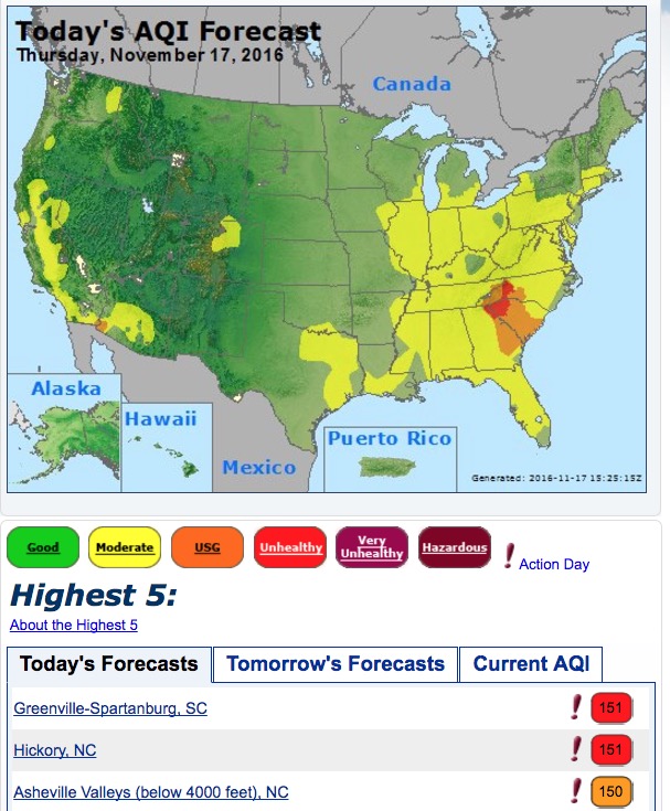
When the Air Quality Index (AQI) is between 101 and 150 due to smoke (the brown color in the AirNow map below) persons with heart and lung disease, older adults, and children are at greater risk. If the AQI is 151 to 200 (red in the map below) according to AirNow everyone may begin to experience health effects; members of sensitive groups may experience more serious health effects.

air quality index wildfire smoke

*

smoke forecast
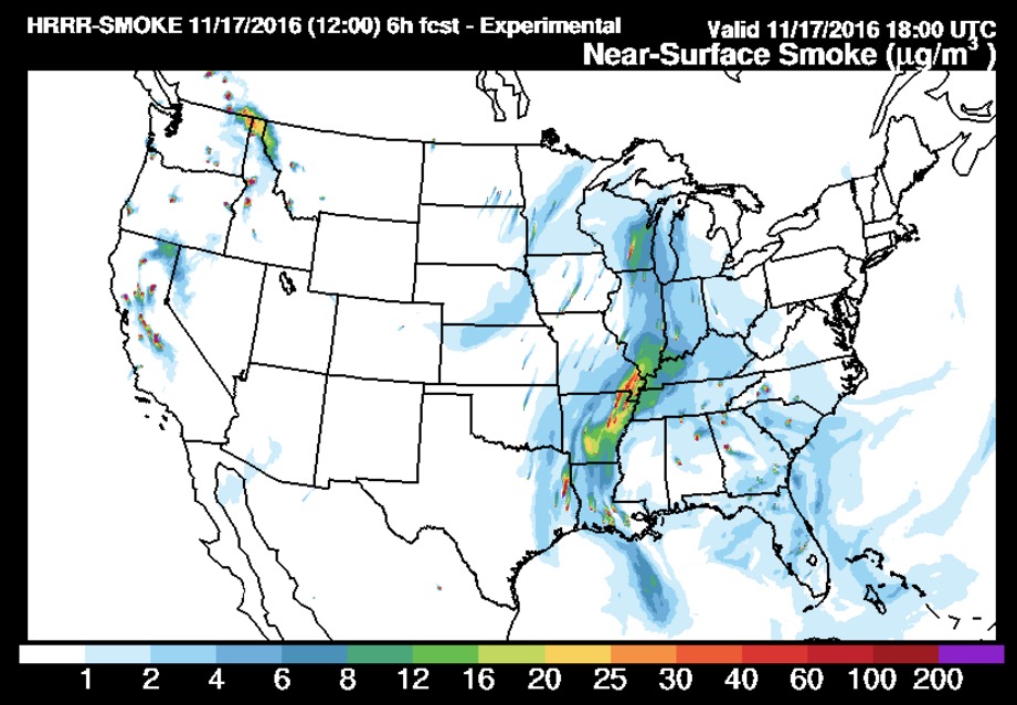
Forecast for smoke from vegetation fires at 1 p.m. ET, November 17, 2016. In addition to the wildfires in Georgia, North Carolina, and South Carolina, it appears that smoke from agricultural burning and prescribed fires in Louisiana and Arkansas is having a significant effect on the air in those two states as well as the midwest. Created at 7 a.m. ET November 17. NOAA.

Many of our readers in the comments sections are asking about the smoke conditions in various locations. Keep in mind that the distribution of smoke is entirely dependant on the location of the fires and the wind direction. A large fire may affect areas in almost any direction if the wind blows it that way. For instance, it can be clear in Gatlinburg, TN one day and the next day it can be smoky.

It can be difficult to predict the impacts of smoke more than a day or two into the future. For one thing, exact wind direction and speed are hard to forecast accurately. And fire activity is even trickier to predict. New fires can break out, older ones can run out of fuel, and the effectiveness of firefighters can vary.

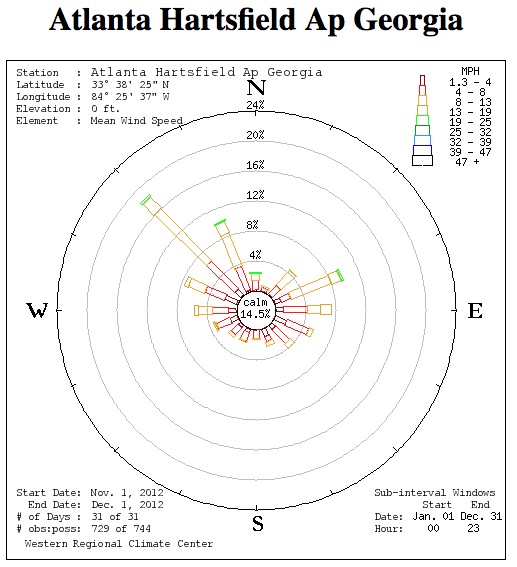
wind rose Atlanta
The “wind rose” for Atlanta, November, 2012. The bars point to the direction the wind was coming from. Western Regional Climate Center.

As you can see in the image above, at Atlanta the most common wind directions during November of 2012 were from the northwest and east, but other directions are also represented.

For the latest articles at Wildfire Today about how smoke from the wildfires is affecting various locations in the South, check out the articles tagged “smoke”.

Update on six wildfires in the South, November 16, 2016

Above: The map shows the locations of some of the larger wildfires currently burning in Tennessee, South Carolina, North Carolina, and Georgia.

Firefighters continue to battle dozens of fires in the southern United States while the residents in the area try to figure out how to live with the smoke.

Fire managers are hoping for a break in the weeks-long dry period, but through Friday at least they should expect more of the same. However there is a chance for rain on Saturday.

Here we will look at six of the larger fires in Georgia, North Carolina, and South Carolina.

Party Rock Fire

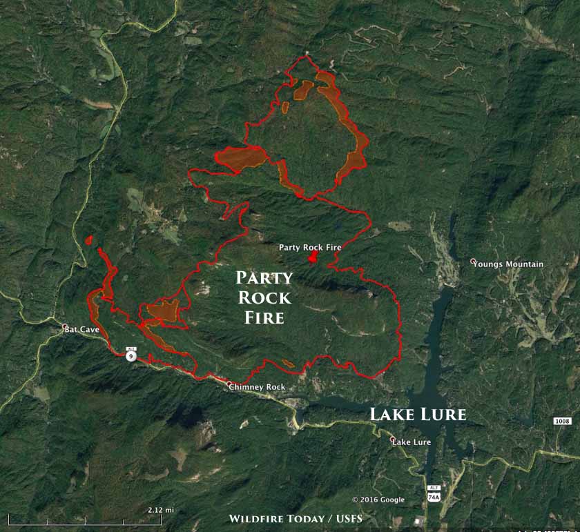
map Party Rock Fire
Perimeter of the Party Rock Fire in North Carolina, 3 a.m. ET November 16, 2016.

The Party Rock Fire has been burning just north of Lake Lure, North Carolina since November 5. It has blackened 4,480 acres, an increase of 736 acres, and forced evacuations at Bat Cave and residences on the east side of Hwy 9. In recent days it has been most active on the north and southwest sides.

Rock Mountain Fire

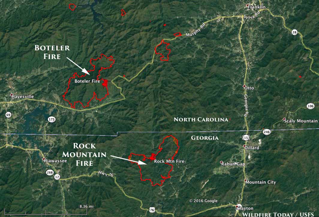
map Rock Mountain Fire Boteler Fire
Perimeters of the Boteler Fire in NC at 11:45 p.m. ET November 15, 2016, and the Rock Mountain Fire in GA at 2 a.m. ET November 16, 2016.

The Rock Mountain Fire has burned 6,747 acres in the northeast corner of Georgia, an increase of 1,263 acres over the previous 24 hours primarily on the northeast and west sides. The Type 1 Incident Management Team reports that 75 structures are threatened, but none have been destroyed.

Continue reading “Update on six wildfires in the South, November 16, 2016”