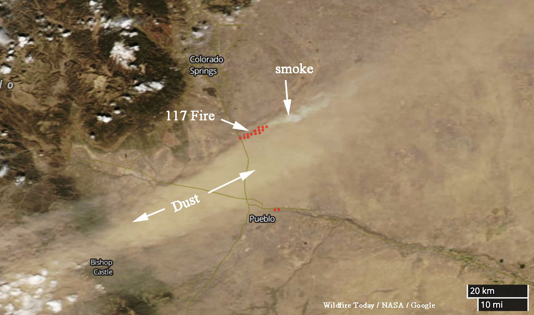
Satellite photo showing the location of the 117 fire south of Colorado Springs. The red dots represent heat detected by a satellite at 2:30 p.m. MDT April 17, 2018.
By Dave Marston
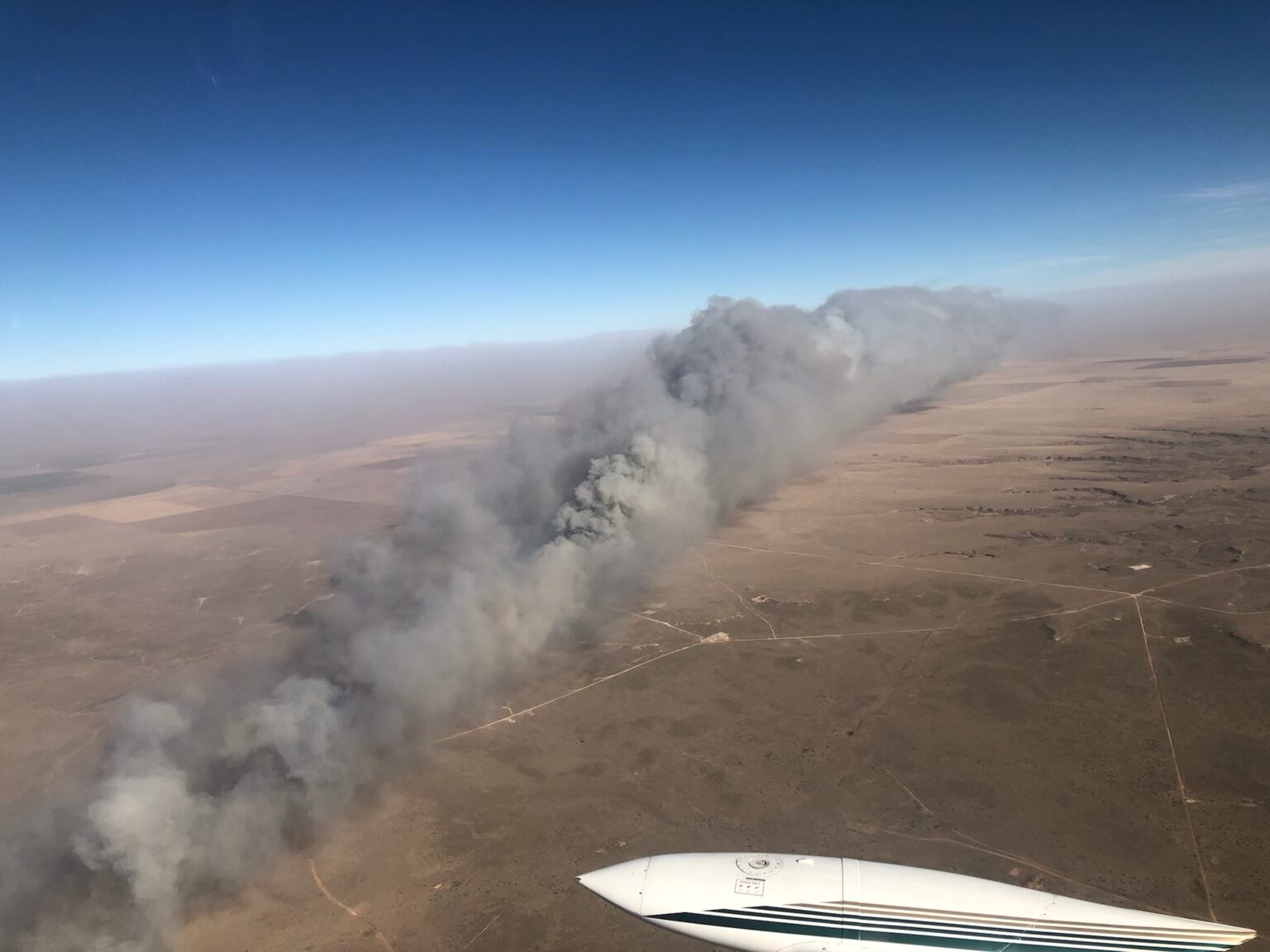
The Marshall Fire that demolished more than 1,000 homes along the front range of Colorado two weeks ago was not unique. This particular kind of fire happened before, on April 17, 2018 — 115 miles due south of the Marshall Fire.
The wildfire was simply called the MM 117 fire for mile marker 117 on Interstate 25 south of Colorado Springs, in El Paso County. Despite earning a federal disaster declaration and scorching over 43,000 acres it never rated a real name.
Like the Marshall Fire, this grass fire came on fast and stopped almost as soon as the winds died. At the time, it was the fifth-largest in state history but 100 percent contained in 72 hours.
It began when a motorist, their car dragging its muffler, sent sparks into the air when there was just 4 percent humidity and winds blowing up to 80 miles per hour. Sparks ignited the grass. Fire investigators on the scene said any motorist with an overheating engine could have sparked a blaze. The entire day it seemed all of Colorado was hammered by winds that grounded planes at Denver International, then grounded firefighting planes as well.
Unable to reach homeowners by car, with the fire racing away, frantic officials resorted to pleas over Facebook message boards: “A deputy sheriff said he was driving at 35 mph near the fire Tuesday, April 17th, 2018, and it was moving faster than he was,” reported Wildfire Today.
The final tally was horrifying for a fire that lasted barely the length of a holiday weekend — 24 structures destroyed, over 43,000 acres scorched, and “untold number of livestock,” mostly beef cattle killed, according to the Colorado Springs Gazette.
Speed was a big part of the story. The fire raced due east and covered 20 miles in just a few hours. Along the way, It leaped over roads, torched houses and seemed impossible to stop. Yet when winds died and rains came, containment of the fire happened quickly.
There is a stunning lesson to be learned from this grassland fire: We have little control over wind-whipped grasslands fires once they get going. All we can do is run.
David Marston
Dave Marston is the publisher of Writers on the Range, writersontherange.org, a nonprofit dedicated to spurring lively conversation about the West.
This article was first published on Writers on the Range.
An effort to help protect these iconic trees from being destroyed in wildfires
Case Mountain. BLM photo by Robert Hedlund Jan. 6, 2022.
The Bureau of Land Management plans to burn up to 1,000 piles of downed hazard trees, branches, and understory brush at Case Mountain Extensive Recreation Management Area (ERMA) southeast of Three Rivers in Tulare County, California. Pile burn operations will start as early as Monday, January 10, and continue periodically until Spring, depending on weather, air quality conditions, onsite observations, and resource availability. Smoke may be visible in Three Rivers.
The ERMA contains the only giant sequoia groves managed by the BLM. They are on Case Mountain approximately 7 miles southeast of the town of Three Rivers, California. The complex is comprised of six distinct sequoia grove units, which total about 444 acres.
The prescribed fire is part of a multi-year fuels reduction effort in the groves. The objective is to strategically thin trees; remove ladder fuels which can feed flames to the treetops; and remove needles, branches, and brush on the forest floor. The prescribed fire will enhance protection of the wildland-urban interface for the town of Three Rivers, improve landscape health, and remove hazardous fuels near giant sequoia trees. Burning will take place only when weather and fuel moisture allow safe and successful operations.
The project is funded by a CAL FIRE grant and is a joint effort of the BLM, CAL FIRE, Tulare County Resource Conservation District, tribes, private landowners, and technical experts. It is closely coordinated with the San Joaquin Valley Air Pollution Control District.
The Case Mountain Forest Health Project is associated with California Climate Investments, a statewide program that puts billions of cap-and-trade dollars to work reducing greenhouse gas emissions, strengthening the economy, and improving public health and the environment – particularly in disadvantaged communities.
Protecting these iconic trees
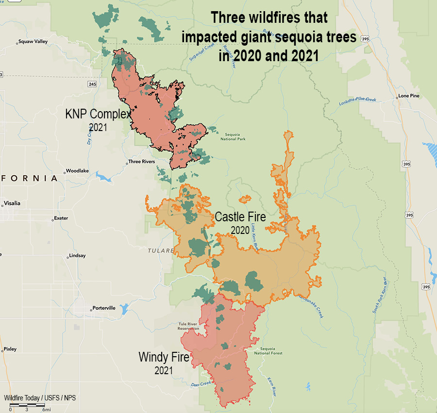
In 2020, 10 to 14 percent of all giant sequoias across the tree’s natural range in the Sierra Nevada that were at least four feet diameter were killed in the Castle Fire when a substantial proportion of all sequoia groves touched by the fire burned with unprecedented severity.
Three fires in two years that killed giant sequoia trees. The darker green areas represent groves of giant sequoias.
In 2021 two additional large fires destroyed more of these iconic beasts of trees — the KNP Complex just north of the Castle Fire, and the Windy Fire which spread into the south side of the Castle Fire. These three fires were primarily in the Sequoia and Kings Canyon National Parks and the Sequoia National Forest.
Film about the fatal 1977 Honda Canyon Fire on Vandenberg Air Force Base in which four were killed
A documentary about the 1977 Honda Canyon Fire is now available for streaming. Firestorm ’77 is based on Beyond Tranquillon Ridge, the book by Joseph N. Valencia about the brush fire that burned across Vandenberg Air Force Base on the California coast northeast of Santa Barbara. It started on December 20 during Santa Ana winds gusting to 100 mph and was fought by over a thousand personnel ranging from full time firefighters to military personnel who had zero experience or training in battling a wildfire.
There were multiple entrapments and 65 injuries. Four were killed.
The winds made the effort from the beginning futile, but military commanders, fearful of the base’s cold war secrets being compromised, attempted to control the strategy. In one case, when a General heard that a firing operation was planned he said he didn’t want any more fire on his base and it was not going to happen. Eventually, he relented.
Almost ten thousand acres burned resulting in significant damage to the military installation’s infrastructure. On the second day the winds were replaced by rain. The Air Force quickly declared it a victory, a battle won by its brave Airmen.
Remarkably, about 15 people who were on the fire 44 years ago were interviewed and appear in the film. Unsurprisingly they have a different take from the interpretation by the Air Force.
The film portrays the events in a way that has nothing in common with the 1998 movie with a similar name, Firestorm featuring NFL player Howie Long. The events are described in a serious, matter of fact manner through interviews with those who experienced it. It also addresses the effects it had on those firefighters, some of whom to this day are still dealing with post-traumatic stress disorder (PTSD). One person still feels guilt, he says, and blames himself for a horrific injury that occurred to someone else.
The documentary could be a useful tool to begin a serious discussion about how firefighting practices have changed in the last 44 years. However, I was a firefighter in 1977 and I never saw a fire managed anything like this one, with decisions made by military officers with no fire experience, and attempting to suppress a fire during 100 mph winds with untrained personnel. One part of the film that could use improvement is the maps, which were a little crude and difficult for me to follow. Of course that comes from a guy who has made hundreds of fire maps, so I’m not your typical map consumer.
In addition to this documentary, a staff ride that has been developed to help transfer the lessons learned is described in the film by a member of the Vandenberg Hotshots, a crew that was created after the fire.
At the time of the fire, Mr. Valencia, the author of the book and producer of the film, was a 19-year old reserve firefighter and hotshot for the Santa Barbara County Fire Department. He was part of the Santa Barbara County “Strike Team” that arrived early where he was involved in two burnovers and two rescues. After the fire he worked for 37 years in Aerospace and Defense programs at Vandenberg Air Force Base and Cape Canaveral, Florida.
I asked Mr. Valencia why he decided to create the documentary.
“The inspiration for the book and the film came from the night of the Honda Canyon Fire back on December 20th, 1977,” he wrote by email. “That night, I felt it very necessary to pray to God to say goodbye to my loved ones, and I asked for God…to save my life. Like many who face situations like this in war or other life or death moments, I prayed that I would do anything that God asked of me, if he could just “spare my life.” I honestly believe that this book and film — is what God asked of me, and it originated from that prayer! I am fulfilling a promise.
“Fast forward many years…
“In 2016 I met Dennis Ford, who was a US Air Force Augmentee on the fire, and who read my book Beyond Tranquillon Ridge. “Dennis was full of anger about the fire, about how Officers sent them out there with no training or proper tools to fight a wind-driven wildfire. He remembered standing at the bottom of a canyon at o-dark-thirty, intuitively knowing that if the fire changed direction and it came towards him, he would not be able to outrun it, and he would meet his maker.
“Dennis and I struck up a conversation, and he indicated he was taking a Film class at Allan Hancock College in Santa Maria. Dennis approached his film studies professor, Mr. Chris Hite, and told him about the fire, and to see if he would be interested in creating a film about the fire. Chris Hite was immediately taken by the story and agreed to give his time and effort to this documentary.
“The three of us Chris Hite (filmmaker), Dennis Ford (Director) and me Joe Valencia (Producer/Author) soon began a four-year journey in to creating our film FireStorm ’77. We all believed in this film, and in telling the story of what happened. All of us feel a little bit of serendipity as to what we have done, where we are, and why it all happened!
“By the way, I think this film has had positive healing effects on myself, Dennis Ford, and the other firefighters we interviewed in the film. The film shows the psychological effects on us all, that the book doesn’t really show.”
Firestorm ’77 has been selected for 33 film festivals. It is streaming on iTunes, GooglePlus, YouTube, and MagellanTV. The cost on YouTube is $4 to rent or $5 to buy.
Part of the Holy Grail of Wildland Firefighter Safety
Map of a fire near Vivonne Bay, Kangaroo Island, Australia, Jan. 9, 2020. FireFlight image.
At Wildfire Today we have often advocated for what we call the Holy Grail of Wildland Firefighter Safety — making available to fire personnel the real time location of the fire and firefighting resources. Several systems for tracking the fire or resources have been demonstrated or used on a small scale by federal land management agencies in the United States. Hundreds if not thousands of law enforcement agencies, fire departments, and private corporations have been using tracking systems for years.
A company in Australia has developed a system to deliver half of the Holy Grail, the real time position of a wildfire. FireFlight Technologies, with CEO Dr. Paul Dare, a long-term South Australian Country Fire Services (CFS) volunteer, has been awarded a $100,000 grant to demonstrate its real time mapping system.
Using infrared thermal sensing equipment in an aircraft it can see through smoke to detect the location of a wildfire.
Below is an excerpt from an article at Cosmos Magazine, January 7, 2022:
…“The other live information we get from the camera system is contextual,” says Dare. “We can see features such as trees, creeks, roads, buildings – even cars. Anyone looking at the map would recognize these features and understand the implications.”
“There are two ways of thinking about it. First, the chief is back at headquarters with a strategic view. They can move a dozen fire appliances from one side of the fire front to the other. This can take hours to achieve.
“Then there are the people on the fire trucks. They’re approaching the fire much more tactically. Their decision making is going to be based on seconds and minutes.”
This summer, Dare’s system will transmit rapidly updating high-resolution images onto a web-based portal. From there, CFS officers can interpret the bushfire’s behavior to reposition ground crews, deploy fire bombers and issue evacuation alerts accordingly.
The technology has already been put through its paces. Data from the sensor was relayed to defense personnel during the 2019–2020 Kangaroo Island bushfires. It’s also been used during recent wildfires in Montana and California.
“We build and supply our own hardware,” Dare said. “We make a set of equipment work together and put it in a box that can be bolted on a helicopter or plane. We give the pilot a portable computer to control it. That way, we know it’s all going to work.”
What’s happening in the United States?
In the US, the John D. Dingell, Jr. Conservation, Management, and Recreation Act required that by March 12, 2021 the five federal land management agencies “…develop consistent protocols and plans for the use on wildland fires of unmanned aircraft system technologies, including for the development of real-time maps of the location of wildland fires.”
While this technology has been demonstrated, real time mapping appears to be far from being used routinely.
The Dingell Act also mandated that the five federal land management agencies “jointly develop and operate a tracking system to remotely locate the positions of fire resources for use by wildland firefighters, including, at a minimum, any fire resources assigned to Federal type 1 wildland fire incident management teams”, due by March 12, 2021.
The US Bureau of Land Management has installed hardware for Location Based Services (LBS) which are now operational on more than 700 wildland fire engines, crew transports, and support vehicles. Vehicle position and utilization data are visually displayed via a web-based portal or mobile device application.
Ten months after it was required by Congress the US Forest Service has made very little progress on this mandate.
Today is the beginning of the fifteenth year of Wildfire Today. Since I wrote that first article it has been a fun, interesting, and occasionaly a challenging journey. As this new year begins I am thankful for our readers (many of whom have been with us since the beginning), visitors who leave thoughtful comments or submit tips, and our sponsors who make it possible to keep the doors open.
Six months after that initial article, @WildfireToday was born on Twitter June 2, 2008. Five years later we spun off Fire Aviation.
A writer says, California’s “honeymoon is over for its residents now that wildfires are almost constant”
Parker Creek Fire, December 15, 2021. Texas Forest Service photo.
Sunday night as I watched the Season 4 finale of Yellowstone, John Dutton, played by Kevin Costner, was talking with another character who said, “I’m terrified of the world we’re leaving (for my grandchildren). I honestly don’t know what this place will look like in 100 years.”
“Grass will cover the streets, and weeds will cover the rooftops,” Dutton said. “I don’t think we make it 100 years.”
I have been thinking about wildfire smoke recently, and how during the last two years massive plumes of smoke from fires in the western states have often migrated east, sending hazardous air laden with tiny PM2.5 particles (2.5 micrometers and smaller) across a dozen states. I learned in a Smoke Management class that if you could drop a PM2.5 particle from eight feet high in a room with still air, it would take about eight hours for it to reach the floor. Smoke with these pollutants is easily transported hundreds or thousands of miles across state and international boundaries. Canada and the United States seem to take turns exporting PM2.5 across the border.
As the sun begins to set on the west coast, gray smoke from wildfires can be easily distinguished from white clouds. NOAA, GOES 17.
In research published online last week in the journal Toxicological Sciences, researchers reported that inhaled microscopic particles from woodsmoke such as PM2.5 work their way into the bloodstream and reach the brain, and may put people at risk for neurological problems ranging from premature aging and various forms of dementia to depression and even psychosis.
Extreme weather conditions that a few decades ago were rare are occurring more frequently, sometime establishing conditions suitable for extreme fire behavior. If this trend continues to increase, where will we be in 10, 20, or 30 years? Or 100 years? Grass on the streets and weeds on rooftops?
Widespread smoke is just one of the symptoms of how climate change is degrading the quality of life for many people on this planet. In the article described below, the author wrote that a researcher told her that “Wildfire is literally making it unsafe to be pregnant in California.”
The article by Elizabeth Weil published Monday in New York Times Magazine is well worth your time. It is a long form piece looking at how wildfires are changing, and the effects. She examines most of the issues that are involved — weather, climate, prescribed fire, indigenous fire, fuel breaks, “managed” fire, human health, fire resistant construction, and the home ignition zone — in a style that makes you want to keep reading, and hoping that you don’t get to the end of the article in the next paragraph or two.
It is behind a pay wall, but that’s the life we have now, or are moving toward. (Yes, even Wildfire Today has considered a subscription fee.)
Here are excerpts from the article, titled, This Isn’t the California I Married — The honeymoon’s over for its residents now that wildfires are almost constant. Has living in this natural wonderland lost its magic?
…Aching and eager to escape my own boring loop of depressive thoughts, I met with Alex Steffen, a climate futurist, on the back patio of a bar in Berkeley. Steffen, a 53-year-old mountain of a man with a crystal-ball-bald pate, hosts a podcast and publishes a newsletter called “The Snap Forward.” The idea behind both is that the climate crisis has caused us to get lost in time and space; we need to dig ourselves out of nostalgia and face the world as it exists. As he explained to me in his confident baritone, yes, California, and the world, are in bad shape. But the situation is not as devoid of hope as we believe. “We have this idea that the world is either normal and in continuity with what we’ve expected, or it’s the apocalypse, it’s the end of everything — and neither are true,” he said. That orange sky in 2020? “We’re all like, Wow, the sky is apocalyptic! But it’s not apocalyptic. If you can wake up and go to work in the morning, you’re not in an apocalypse, right?”
The more accurate assessment, according to Steffen, is that we’re “trans-apocalyptic.” We’re in the middle of an ongoing crisis, or really a linked series of crises, and we need to learn to be “native to now.” Our lives are going to become — or, really, they already are (the desire to keep talking about the present as the future is intense) — defined by “constant engagement with ecological realities,” floods, dry wells, fires. And there’s no opting out. What does that even mean?
We’re living through a discontinuity. This is Steffen’s core point. “Discontinuity is a moment where the experience and expertise you’ve built up over time cease to work,” he said. “It is extremely stressful, emotionally, to go through a process of understanding the world as we thought it was, is no longer there.” No kidding. “There’s real grief and loss. There’s the shock that comes with recognizing that you are unprepared for what has already happened.”
…
Relinquishing the idea of normal will require strength, levelheadedness, optimism and bravery, the grit to keep clinging to some thin vine of hope as we swing out of the wreckage toward some solid ground that we cannot yet see. “We’re no longer dealing with a fire regime in the woods that responds to the kinds of mild prevention and mild responses, the sensible responses we have thought about, and that thought alone is a crisis,” Steffen said. “It means the lives we had we no longer have.”
…
This brings us to one other forest- management tool in the knife: “managed wildfire.” This one, however, does not always pair well with the other overabundant species out there in California: people.
…
This summer, in Kings Canyon, as the wildfires approached, firefighters wrapped giant sequoias in aluminum foil. This included General Sherman — 2,200 years old and the largest single tree on Earth. This act was meager, and it was devotional. It’s what we’ve got now. The good news is, some of the moves we need to make are easier, more straightforward and more under our control than we imagined, if we’d just allow ourselves to get them done. The bad news is that there is just going to be loss. We’re not used to thinking about the world that way. We’re not used to paying for our mistakes.