Above: Comet Fire, July 28, 2016. Photo by Bill Gabbert.
The heli-rappellers at the Salmon, Idaho airport saw the lightning strike on July 26 that caused the Comet fire 12 miles north of the town. So far it has burned 356 acres above the Salmon River near Highway 93.
Map showing the location of the Comet Fire 12 miles north of Salmon, Idaho, July 28 , 2016.
The fire is being fought by four helicopters, seven engines, one Type 2 initial attack 22 person crew, one Hotshot crew, four heli-rappellers, and four smokejumpers.
The Comet Fire north of Salmon, Idaho. Photo by Bill Gabbert. Click to enlarge.A K-MAX helicopter drops water on the Comet Fire north of Salmon, Idaho July 28, 2016. Photo by Bill Gabbert. Click to enlarge.
The operator of a bulldozer was killed while working on the Soberanes fire, one of two major wildfires burning in California and one that has already destroyed 20 homes.
The operator was killed when the bulldozer rolled over, and another operator was injured in a similar incident, The Associated Press reported on Wednesday. Other reports say the dozer operator died of injuries on Tuesday night.
The bulldozer operator was working on a call-when-needed basis overnight when the fatal accident occurred, according to information posted on CAL FIRE’s website. The dozer was one of 60 assigned to the fire in Monterey County.
Officials have not yet released the name of the operator who was killed. California’s other major blaze, the Sand fire, killed a man this week outside of Los Angeles.
UPDATE April 17, 2017: KQED reports that the name of the dozer operator that was killed was Robert Reagan.
Check back with wildfiretoday.com for more on this story.
Thanks and a tip of the hat go out to Chris and Daniel.
In the first 13 days since starting from a lightning strike, the Lava Mountain Fire 12 miles northwest of Dubois, Wyoming had been steadily growing, but generally not at a rapid pace. That began to change on Sunday when the rate of spread picked up significantly and it added an additional 1,200 acres for a total of 5,488 acres. On Monday it added at least that much again and according to our very rough, unofficial estimate had burned approximately 7,000 acres by 3 p.m. on Monday.
Most of the recent growth is on the south and southeast sides.
The red dots represent heat detected on the Lava Mountain Fire by a satellite at 3:01 p.m. MDT July 25, 2016. The red line was the fire perimeter mapped by an infrared aircraft at 11 p.m. MDT July 24, 2016. Click to enlarge.
Currently, the south flank of the fire is pushing east and hooking around near the Sand Butte area. According to information released by the incident management team on July 25, “If the direction of spread continues, the fire will be lined up to be pushed by the wind towards the Union Pass road. For these reasons the following areas are in stage “GO” and should evacuate immediately: Union Pass, Warm Springs, Porcupine, and Hat Butte.”
The weather forecast for the fire area calls for strong winds Monday night, but slowing on Tuesday and Wednesday to come out of the west and southwest at 6 to 13 mph. The temperatures will be in the high 70’s and relative humidity in the teens through Wednesday.
A firefighter with the Orford New Hampshire Fire Department died in the line of duty on Sunday July 25 while fighting a wildfire.
Charles Waterbury, a 10-year veteran of the Department, suffered a medical emergency at a lightning-caused fire. He was taken to a hospital where he was pronounced dead.
Governor Maggie Hassan has ordered all flags to fly at half-staff until Wednesday.
“Charles Waterbury courageously rushed to fight a brush fire in Lyme to protect his fellow citizens, and in doing so, was tragically taken from us far too soon,” Governor Hassan said. “Through his service in the Orford Fire Department and the New Hampshire National Guard, Charles dedicated his life to keeping others safe, and his heroic commitment to public service has strengthened our state and our nation. Tom and I join all Granite Staters in mourning his tragic loss, and it is our responsibility as Granite Staters to come together in support of Charles’ family, loved ones, fellow firefighters and the entire Orford community.”
Our sincere condolences go out to Mr. Waterbury’s friends, family, and fellow firefighters.
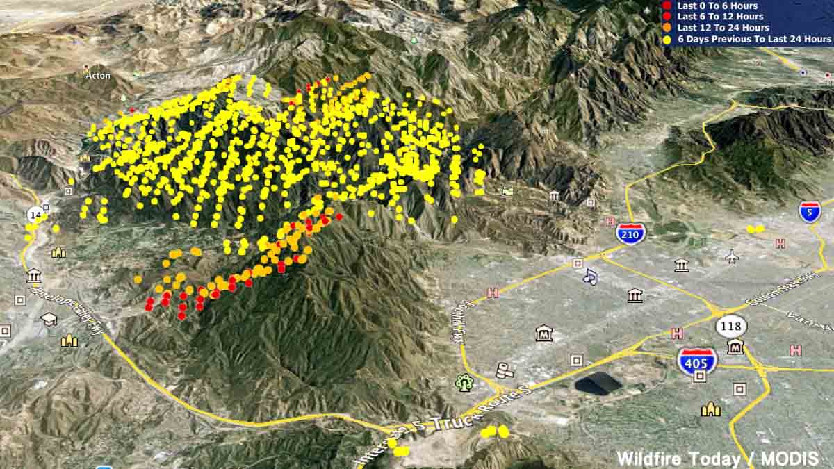
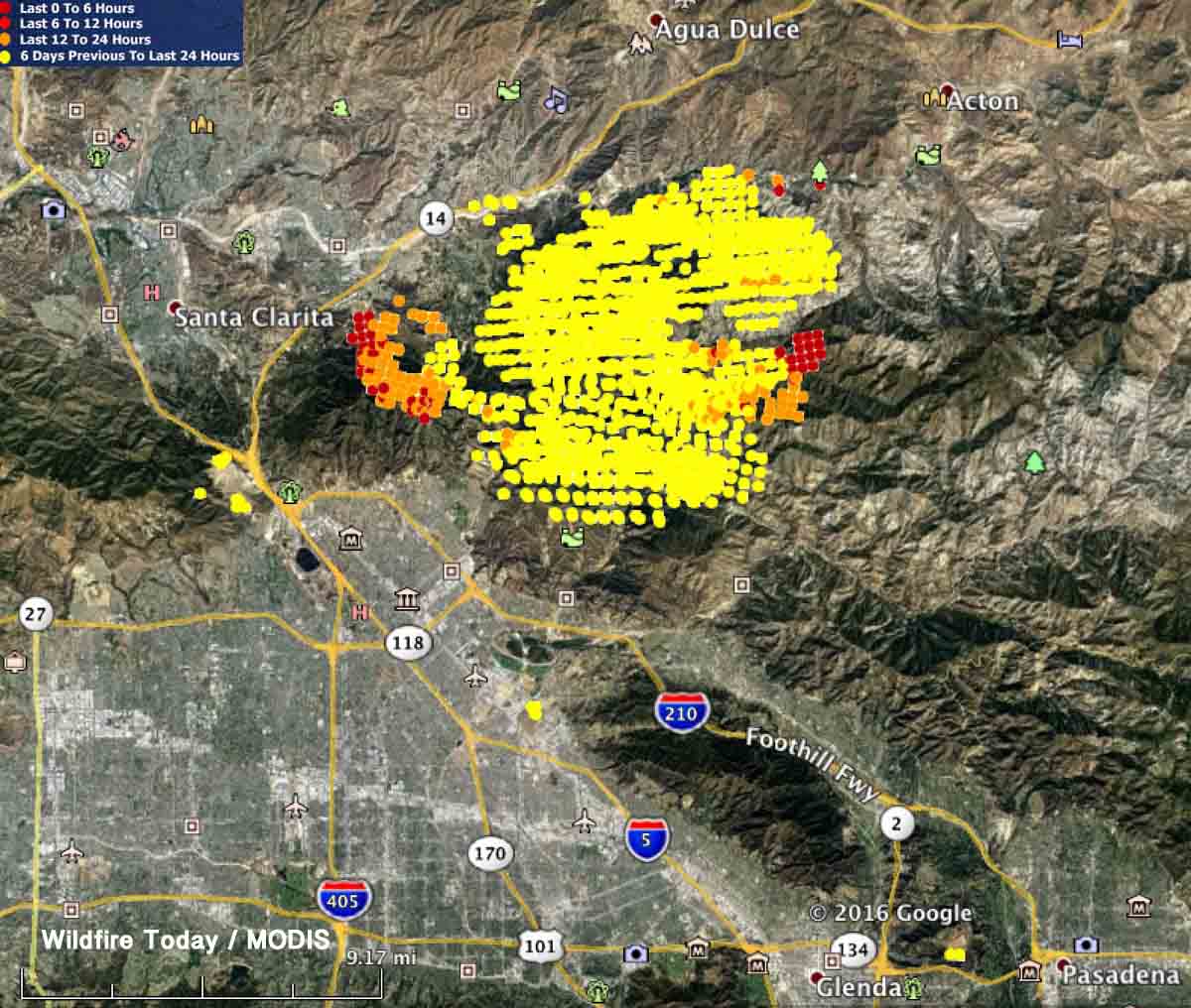
3-D Map of the Sand Fire, looking east. It shows heat detected by a satellite. The red dots are the most current, detected at 2:01 p.m. PDT July 25, 2016.
(Updated 12:34 p.m. MDT, July 26, 2016)
Officials in Los Angeles have identified the body of Robert Bresnick, 67, who was found dead Saturday in a neighborhood burned by the Sand fire.
The fire has also destroyed at least 18 homes. Many of the thousands of residents who were forced to evacuate were allowed to return home Monday night.
The Sand fire continued to rage outside of Los Angeles on Monday, and while firefighters still struggled to contain it, thousands of evacuation residents were allowed to return home.
(Maps of evacuation zones and lists of neighborhoods can be found here.)
On Tuesday the Los Angeles County Board of Supervisors is expected to declare the Sand fire — which has destroyed 18 homes and possibly killed one person — a local emergency, a declaration that usually paves the way for grant funding to help communities recover after natural disasters.
Near the city of Santa Clarita, the fire grew by more than 10,000 acres on Sunday, according to the incident management team’s Monday-morning updates. By Monday night the fire spanned more than 35,000 acres and remained only 10 percent contained.
Map showing heat detected on the Sand Fire by a satellite. The red dots are the most current, detected at 2:01 p.m. PDT July 25, 2016. At that time the fire was actively spreading on the east side, as well as on the west side, east of Santa Clarita and Highway 14.Here are some updated stats on resources:
3,379 firefighters are engaged on the Sand Fire,
Resources: 435 engines, 54 hand crews, 26 helicopters, 22 dozers and 17 water tenders.
On Sunday, aircraft were briefly kept from the skies over the Sand fire when a personal drone was spotted in the area. While aircraft were only out of commission for 30 minutes (according to local media reports), this was the second time in a week that aircraft were downed because a drone. A similar incident in Montana occurred on the same day.