Arizona: Tenderfoot Fire causes evacuations in Yarnell

(UPDATED at 7:34 p.m. MDT June 11, 2016)

The Tenderfoot Fire at Yarnell, Arizona grew slowly on Saturday and is now at 4,040 acres, according to the incident management team. Fire activity was moderated by moisture received on the fire Friday night, along with cooler daytime temperatures and higher relative humidity.

Incident Commander Sinclair stated that “work of the heavy air tankers made a significant contribution towards reducing the spread of fire on the north side of the incident yesterday”.

Highway 89 is now open and the mandatory evacuation on the east side of Yarnell was lifted at 6 p.m. on Saturday. There are no other evacuation orders in effect.

Resources assigned include 8 hand crews, 22 engines, 5 helicopters, 3 dozers, and 353 personnel.

****

(UPDATED at 9:18 p.m. MDT June 10, 2016)

The Incident Management Team provided some updated information Friday afternoon about the Tenderfoot Fire at Yarnell, Arizona:

The fire is currently moving away from the Community of Yarnell in a northeasterly direction, an area where very few structures are present. This area is very rugged in character with very little access. Fire managers will be looking for opportunities to the northeast of the current fire area where firefighters can safely engage and suppress the fire south of Wagoner Road.

There are currently no immediate threats to structures. Over the last few years fuel reduction projects were completed on the east and north sides of the Community of Yarnell. Fire Chief Ben Palm stated that these fuel breaks significantly reduced the fire intensity of the Tenderfoot Fire as it approached the community, allowing firefighters to attack the fire and greatly reduce property loss. The fuel breaks were the result of a partnership between the Community and Arizona State Forestry and the Bureau of Land Management.

This afternoon the Yavapai Sheriff’s Office announced the opening of State Highway 89 at 4:00 p.m.

****

(UPDATED at 8:45 a.m. MDT, June 10, 2016)

Tenderfoot Fire
Tenderfoot Fire, June 9, 2016. InciWeb photo.

The Tenderfoot Fire at Yarnell, Arizona was very active Thursday afternoon and Thursday night, more than doubling in size to approximately 3,300 acres according to information released by the incident management team. That acreage may change after personnel map the fire via helicopter later today.

map Tenderfoot Fire
Map showing the perimeter of the Tenderfoot Fire. The red line was mapped using a fixed wing aircraft at about 11 p.m. MDT, June 9. The red dots represent heat detected by a satellite at 4:29 a.m. MDT June 10, 2016.

The Southwest Area Type 2 Incident Management Team #3, with Incident Commander Alan Sinclair, assumed command of the fire at 6 a.m. on Friday.

****

(UPDATED at 10:40 p.m. MDT, June 9, 2016)

The Tenderfoot Fire at Yarnell, Arizona south of Prescott became more active in the late afternoon on Thursday and has now burned over 1,300 acres. The heat data in the map below acquired at 2:27 p.m. MDT on Thursday showed additional fire spread on the east and the northeast sides.

At about 3 p.m. a mandatory evacuation notice for Peeples Valley on the east side of Highway 89 was issued. It was a precautionary evacuation and with no imminent threat at that time.

Tenderfoot Fire 227 pm
Map showing heat detected by a satellite on the Tenderfoot Fire at 2:27 p.m. MDT June 9. It is possible that some light vegetation burned and cooled before the heat data was captured — the fire could be larger than indicated here.

The increase in fire behavior was a result of the wind increasing to 13 mph after noon, while the relative humidity dropped to 18 percent.

weather yarnell AZ
Weather observations at ASTA3 just southeast of Yarnell, AZ.

Continue reading “Arizona: Tenderfoot Fire causes evacuations in Yarnell”

Massachusetts man indicted for planting incendiary devices at powerline

One of the devices started a fire March 31.

This follows up on the first report of the incident on April 1, 2016.

Below is an excerpt from an article in the Lowell [Massachusetts] Sun:

****

“A Chelmsford man accused of planting explosive devices on National Grid power lines in Tyngsboro [Mass.] in March was indicted by a federal grand jury on Tuesday.

Danny Kelly, 61, of Chelmsford, was indicted on a charge of malicious destruction of property by fire. He has been held without bail since his arrest after Tyngsboro firefighters on March 30 responded to Locust Avenue near National Grid power lines for a brush fire that officials suspect was caused by one of five incendiary devices found at the scene.

A note found at the scene explained that the devices were designed to cause disruption to power from Canada to the United States.

Investigators focused on Kelly because in a 2004 case he was convicted of cutting 18 phone and cable lines in an extortion attempt against Nortel Networks, his former employer.

Kelly pleaded guilty to extortion and in 2006, a federal judge sentenced him to five years probation, ordered him to undergo mental-health treatment, possess no destructive devices and pay $378,041 in restitution.

As part of his 2004 case, Kelly was evaluated by Dr. Roger H. Gray, who performed a forensic psychological evaluation. Gray diagnosed Kelly as having symptoms of bipolar and paranoid-personality disorders.

After the incendiary devices were discovered on the National Grid power lines, a raid of Kelly ‘s 26 School St. home by the FBI and other officials yielded chemicals that could be used to make the pipe-bomb-type devices…”

Release date set for film about Yarnell Hill Fire

Lionsgate, the studio producing the film about the Yarnell Hill Fire, has selected a September 22, 2017 release date. With a screenplay written by Ken Nolan and Eric Warren, it will attempt to tell the story of the 19 members of the Granite Mountain Hotshots that were killed on the fire near Prescott, Arizona in 2013. The name of the film was recently changed from “No Exit” to “Granite Mountain”.

It has an impressive cast lined up to be directed by Joseph Kosinski, starring Josh Brolin, Andie MacDowell, Miles Teller, Jennifer Connelly, Jeff Bridges, Taylor Kitsch, James Badge Dale, and Ben Hardy. At least some of the movie will be filmed in New Mexico.

Wildfire Today has learned that the producers of the film are interested in the posters about the 13/18 Watchout Situations. Below is an example of one that was hand-colorized by a member of the El Cariso Hotshots in 1972.

My brief encounter with Muhammad Ali

Above: Muhammad Ali at the Minneapolis-Saint Paul airport, 1997. Photo by Bill Gabbert.

In January of 1997 I had a very brief encounter with Muhammad Ali at the Minneapolis-Saint Paul airport. I was walking down a corridor and saw him shuffling toward me with his entourage. He had been diagnosed with Parkinson’s syndrome 13 years before and some of the symptoms were evident as he got closer.

Having always respected him as a person and an athlete, I wanted to take a picture as he walked by. As quickly as I could I took off my backpack, put it on the floor and started digging through it to find my camera. He kept getting closer and I was running out of time. Finally I found the camera, removed it from the backpack and began taking it out of the case.

Glancing up to see if I still had time to get the photo, I saw Ali look at me and he stopped walking. He watched as I stood up and raised the camera. Just as I pressed the shutter he and his group were distracted by something off to my right. Then he looked at me as I lowered the camera and he resumed his shuffling down the corridor with his entourage. I said “Thank you” as he passed by.

He was kind enough to stop what he was doing to allow me to get my camera out and take his picture. He did not have to do that, of course.

May he rest in peace.

California: Coleman fire, southwest of King City

(UPDATED at 5:15 p.m. PDT June 8, 2016)

The incident management team running the Coleman Fire southwest of King City, California has not revised the reported size in the last two days. They say it’s holding at 2,340 while being attended by about 1,000 personnel, however some of those are being released.

The team’s report Tuesday morning:

Fire crews made good progress again yesterday. Most of the fireline on the south and east side of the fire is contained. Crews were able to access and line several of the “fire fingers” on the west side of the fire in the Ventana Wilderness. The contingency dozer line on the west side of the fire was completed. Crews mopped-up and patrolled the fireline throughout the night on the east side of the fire.

The priority for [Tuesday] and the next several days will be constructing direct fireline on the west side of the fire in the Ventana Wilderness. There is a significant amount of open line that needs to be completed. This area is very steep and remote and line production is slow and difficult. Mop-up and patrol will continue on the other portions of the fire. Air support from both air tankers and helicopters is available to assist ground crews.

****

(UPDATED at 8:58 p.m. PDT, June 6, 2016)

Coleman Fire June 6, 2016
Coleman Fire June 6, 2016 InciWeb photo.

The Coleman fire is not spreading. It fact it is shrinking. Sunday morning the incident management team said it had burned 3,500 acres. Then Monday morning it was 3,200 acres. The latest report from the team has it at 2,340 acres.

Within a few hours of it starting on Saturday the Southern California Geographic Area Coordination Center (OSCC) reported that the fire had “the potential to burn 10,000 to 35,000 acres”. So either the weather cooperated and slowed the spread, or the firefighters did a masterful job of knocking it down. Probably some of both is the answer. There are many residences northeast of the fire between the current perimeter and King City, only 8 miles away. The National Interagency Coordination Center’s Incident Management Situation Report Monday morning reported that one structure has burned in the fire. Considering the very rapid spread during the first few hours, that should be considered a good outcome.

****

(UPDATED at 9:21 a.m. PDT, June 6, 2016)

Coleman Fire
Approximate perimeter of the Coleman fire at 3 a.m. PDT June 6, 2016. There may be additional acres that were not detected by the airborne heat sensors. Click to see larger version.

The Coleman Fire 8 miles southwest of King City, California has not grown much over the last 24 hours. Some of the smoke seen by residents on Sunday was caused by backfires or burnouts conducted by firefighters to secure control lines.

The incident management team is calling it 3,200 acres, down from the 3,500 figure they released on Sunday.

Resources assigned include 658 personnel, 11 hand crews, 80 engines, and 4 helicopters. One structure has burned. The estimated suppression cost as of Sunday was $1.2 million.

The weather forecast for the fire area on Monday predicts 97 degrees, relative humidity of 13 percent, and north to northeast winds at 6 to 10 mph. The conditions on Tuesday will be similar.

Weather forecast Coleman Fire
Weather forecast for Coleman Fire, generated at 9:15 a.m. PDT June 6, 2016. NWS. Click to see larger version.

****

(UPDATED at 12:45 p.m. PDT, June 5, 2016)

At noon today the Southern California Geographic Area Coordination Center (OSCC) stated that the Coleman Fire southwest of King City, California will exhibit “extreme fire behavior as the day goes on” and that multiple residences are out in front of the fire. They are calling it 3,500 acres.

****

(UPDATED at 11 a.m. PDT June 5, 2016)

McGowan’s Type 1 incident management team has been mobilized to the Coleman Fire which has spread to within eight miles of King City, California overnight. The team and will inbrief at 10 a.m.

The Monterey County Sheriff’s Office reported at 10:20 a.m. that deputies assisted with mandatory evacuations and remain in the area in case other evacuations are needed. Deputies started evacuations on Reliz Canyon and worked their way down to Elm Ave. They did the same on Monroe Cyn.

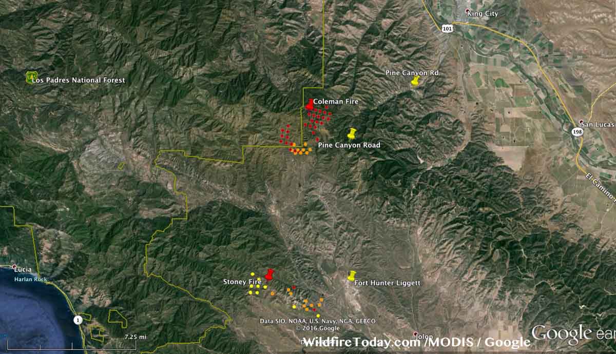
The map of the fire below shows that it spread significantly to the north and northeast in the 12 hours before 3:23 a.m. PDT, June 5. Using the heat data collected by a satellite at that time, we estimate the size to be 1,200 to 1,700 acres. However, some areas within the fire have light fuel such as grass which could burn and then cool before the next satellite overpass and would not be detected, thereby giving us an underestimated acreage count.

The green line is the border of the Los Padres National Forest. The Forest is on the left side of the line. Click on the maps to see larger versions.

Coleman fire map
Map showing heat detected by a satellite at 3:23 a.m. PDT on the Coleman Fire. The red dots are the most recent. The map also shows the Stoney Fire on Fort Hunter-Liggett, which did not spread as much overnight as the Coleman Fire.

The map of the Coleman Fire below is in 3-D, looking northeast toward King City.

Coleman fire map 3-D
Map in 3-D showing heat detected by a satellite at 3:23 a.m. PDT on the Coleman Fire. The red dots are the most current. We are looking northeast toward King City, California.

Continue reading “California: Coleman fire, southwest of King City”

Wildfire dispatching in Russia

В 2012 году была образована Федеральная диспетчерская служба лесного хозяйства. Сотрудники ФДС проводят ежедневный мониторинг лесопожарной обстановки на территории лесного фонда и землях иных категорий. Предоставляют полную информацию о динамике лесопожарной обстановки, наращивании сил и средств на тушение лесных пожаров в субъектах РФ для работы оперативного штаба Федерального агентства лесного хозяйства. Специалисты ФДС, также являются операторами Прямой линии лесной охраны, на которую по единому бесплатному номеру 8-800-100-94-00 в круглосуточном режиме наши граждане сообщают о различных происшествиях в лесу – возгораниях, незаконных рубках, свалках мусора и др., а также получают консультации по интересующим их вопросам. Лесники благодарят всех, кто не остался равнодушным и сообщил об увиденном дыме, свалке или незаконной рубке. #леснойпожар #лес #пламя #героизм #парашютисты #десантники #огонь #пожар #лесной_пожарный #Avialesookhrana #Forest #fire #firefighter #smokejumpers #лесныепожары #bomberos #авиация #firefighterslife #пламя #helicopter #aviation #aviales #экстрим #air #plane #sky #bombeiros #авиация #авиалесоохрана

A photo posted by Федеральная Авиалесоохрана (@avialesookhrana) on

Google’s machines translated the caption:

“avialesookhranaV 2012 Federal dispatch Forest Service was established. Employees FDR conducted daily monitoring of the forest fire situation in the territory of the forest and lands of other categories. It provides complete information on the dynamics of the forest fire situation, a buildup of forces and means for extinguishing forest fires in the regions of Russia for the operational staff of the Federal Forestry Agency.

FDR Specialists are also operators of hotline forest protection, which according to a single toll-free number 8-800-100-94-00 round the clock our citizens informed about various incidents in the forest -. Fire, illegal logging, garbage dumps, etc., and also receive advice on matters of mutual interest.

Foresters are grateful to all those who did not remain indifferent and told about what they saw smoke, landfill or illegal logging.
Lesnoypozhar # # # Forest flame heroism # # # paratroopers paratroopers fire # # # fire lesnoy_pozharny #Avialesookhrana #Forest #fire #firefighter #smokejumpers # lesnyepozhary #bomberos # Aviation #firefighterslife # flame #helicopter #aviation #aviales # extreme #air #plane #sky #bombeiros # # aviation Avialesookhrana”


And then there’s this, which appears to be about prescribed fire:


Google’s translation:

“We give the opportunity to burn a large forest debris (waste), releasing a fire in the forest. Then we bring down the flame
We give the opportunity to burn forest debris. We produce fire in the forest. then extinguish the flames
____
# # Avialesookhrana FFA KhMAO # # # Soviet Yugorsk #avialesookhrana #rosleshoz #hmao #smokejumpers #smokejumper #firefighter #firefighters #bomberos #russia #yugorsk #sovetskiy
patriotic.usMy God!”