Glendower Fire (aka Almeda Fire) burns toward Medford, Oregon

Multiple structures have burned

Updated September 9, 2020 | 9:04 a.m. PDT

Map Almeda Drive and South Obenchain Fires
Map of the Almeda Drive and South Obenchain Fires at 4:14 a.m. PDT Sept 9, 2020.

A second fire in the Medford, Oregon area, the South Obenchain Fire north of the city, is prompting evacuations in the Shady Cove and Eagle Point areas. Evacuation maps are HERE.


September 9, 2020 | 8:33 a.m. PDT
Map of the Almeda Drive Fire
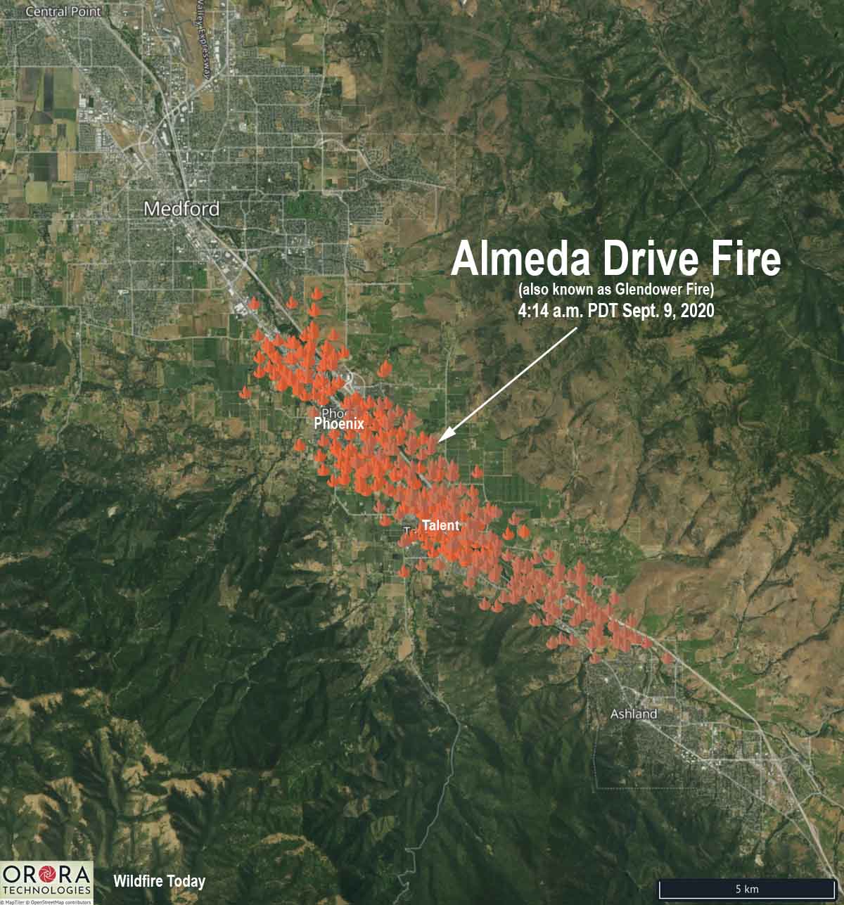
Map of the Almeda Drive Fire (Glendower Fire) at 4:14 a.m. PDT Sept. 9, 2020. The icons represent heat detected by satellites.

Here is an updated map of the Almeda Drive Fire (previously known as Glendower) showing heat detected by satellites at 4:14 a.m. PDT September 9, 2020. There has been much confusion about the name of the fire, but we have information from a fire official that the correct name is Almeda Drive.

The blaze started north of Ashland late Tuesday morning and roughly followed the Interstate 5 corridor as strong winds pushed it northwest. It burned through parts of Talent and by 4:14 a.m. Wednesday was at Phoenix.

Oregon Governor Kate Brown declared the Almeda Drive Fire a conflagration, a large fire which destroys a great deal of land or property. This will allow the state to send resources to assist local agencies.

At about 12:15 Wednesday morning the Oregon Department of Forestry estimated the blaze had burned 2,500 to 3,000 acres.

The Oregon State Fire Marshal incident management team arrived on scene at 1:50 a.m. Wednesday.

Evacuations are in effect for parts of Jackson County and the Medford area. Jackson County and MedfordAlert have evacuation information.


September 8, 2020  |  10:10 p.m. PDT
map Glendower Fire
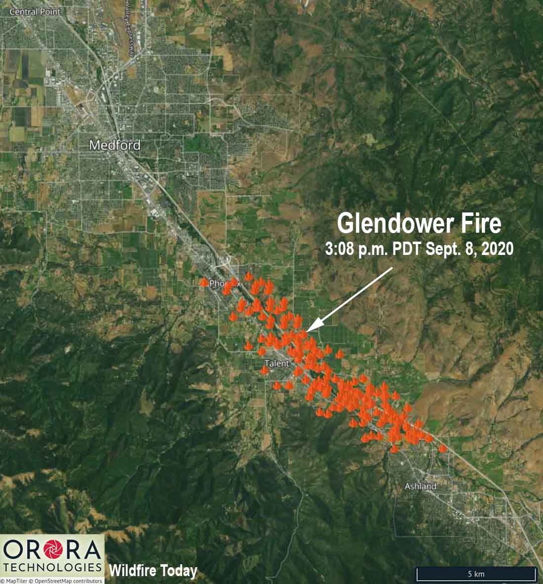
The icons represent heat detected on the Glendower Fire by satellites at 3:08 p.m. PDT September 8, 2020.

The Glendower Fire started north of Ashland, Oregon Tuesday morning then spread northwest along the Interstate 5 corridor (see the map above). At 5 p.m. it prompted evacuations of the entire city of Phoenix, Oregon. The incident is also known as the Almeda Fire.

By 8:45 p.m. evacuations were ordered in areas of Medford and multiple structures had burned. Jackson County and MedfordAlert have evacuation information. MedfordAlert said at 9:56 p.m. an evacuation center has been established at the Josephine County Fairgrounds on Redwood Avenue in Grants Pass. The Jackson County Expo is full.

Tuesday evening sections of Interstate 5 were closed north of the California/Oregon border. TripCheck has current status of the Interstate.

A Red Flag Warning is in effect for the Medford area Tuesday night and Wednesday. The wind direction in Medford will be variable Tuesday night at 3 to 5 mph with the humidity in the teens. On Wednesday the wind will increase at 11 a.m. from the southeast at 15 mph gusting to 23 while the humidity decreases to 7 percent. Wednesday’s high temperature will be 100.

Strong winds spread numerous wildfires in Oregon and Washington

An unprecedented number of fires and acres have burned in recent days

September 8, 2020 | 9:23 p.m. PDT

satellite photo fires smoke Washington, Oregon, and California
GOES-17 photo of smoke from wildfires in Washington, Oregon, and California at 5:56 p.m. PDT Sept. 8, 2020.

The number of wildfires and acres burning in Washington and Oregon are reaching a level that is close to unprecedented in recent memory.

Tuesday afternoon the western one-quarter of Oregon was inundated with dense smoke from multiple fires south of Portland and mostly east of Interstate 5. Strong winds are turning small fires that were ignited weeks ago in Marion County, Oregon into major incidents as law enforcement officers and firefighters try to stay ahead of the fires evacuating residents in their paths.

map wildfires in Washington and Oregon
Map showing heat detected by satellites on wildfires in Washington and Oregon at 4:18 p.m. PDT September 8, 2020.

Thousands of Oregonians were under evacuation orders Tuesday. OPG.org reported that officials said they were so focused on protecting lives and property that suppressing the blazes consuming hundreds of thousands of acres would have to wait. “Our number one priority is evacuation and basic life safety,” said Mariana Ruiz-Temple, chief deputy state fire marshal. “This wind event does not give us the opportunity to really get in there and fight fire how we might fight fire in previous events.”

The Glendower Fire started north of Ashland, Oregon then spread northwest along the Interstate 5 corridor into Medford. Much of the city is under evacuation orders and multiple structures have burned. (More information about the Glendower Fire, including a map.)

Glendowner Fire Oregon Medford
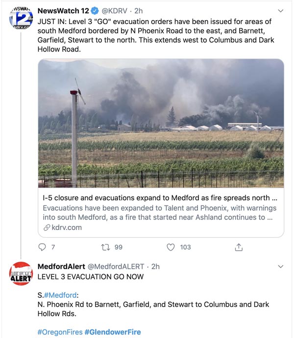
Tweet at 7:04 p.m. PDT Sept 8, 2020.

Strong winds accompanying a cold front was the primary force responsible for the rapid spread of the fires, but some of the driest conditions seen in decades led to low moisture content in vegetation that made large quantities of fuel available to quickly ignite.

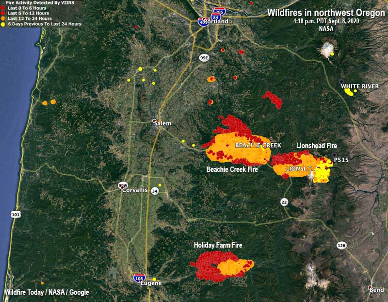
map wildfires in northwest Oregon
Map showing heat detected by satellites on wildfires in northwest Oregon, south of Portland at 4:18 p.m. PDT September 8, 2020.

The New York Times reported the National Weather Service on Tuesday placed Northwest and southwestern Oregon under an extreme fire danger warning, the first time southern Oregon has been the subject of such a warning, according to the Oregon Climate Office. The Oregon Department of Corrections evacuated 1,450 inmates from three prisons east of Salem.

The New York Times:

Gov. Jay Inslee of Washington said on Tuesday that an estimated 330,000 acres had burned across the state on Monday, more than what burned in each of the last 12 fire seasons. “The devastation is all over our state,” Mr. Inslee said in a news briefing.

One of the smaller fires in Washington, relatively speaking,  wiped out about 80 percent of the structures in Malden, a town of 200 people south of Spokane. Officials said the buildings that burned included the fire station, post office, city hall, and the library.

Three of the largest blazes in Washington are Cold Springs south of Omak (163,000 acres), Pearl Hill east of Brewster (174,000 acres), and Evans Canyon north of Yakima (75,817 acres). The Pearl Hill fire reportedly burned 170,000 acres within 24 hours.

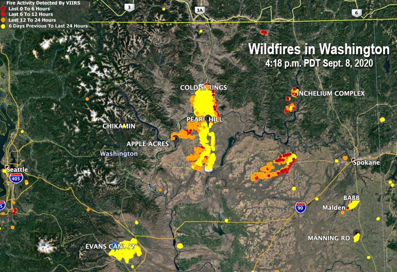
map fires Washington
Map showing heat detected by satellites on wildfires in Washington at 4:18 p.m. PDT September 8, 2020.

15 firefighters on Dolan Fire became entrapped by the fire and deployed fire shelters

One injury is critical and another is serious, the U.S. Forest Service reported

September 8, 2020  |  5:05 p.m. PDT

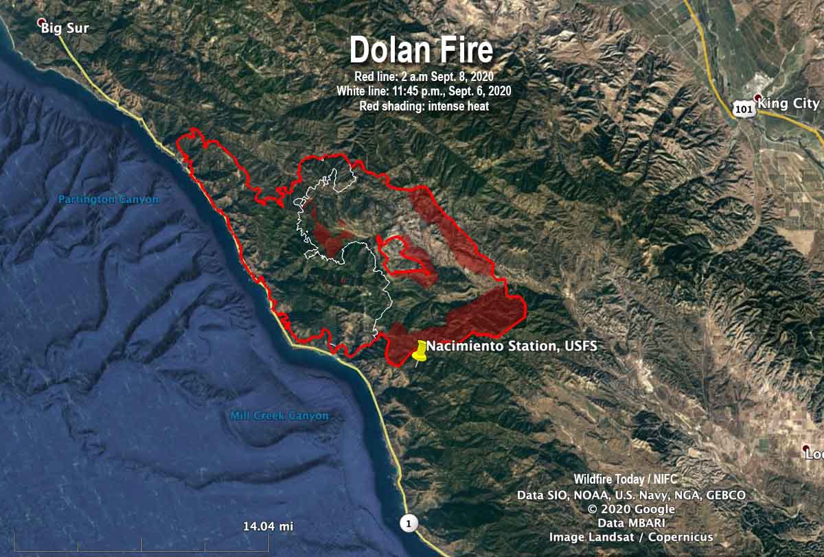
Map of the Dolan Fire
Map of the Dolan Fire. The red line was the perimeter at 2 a.m. PDT September 8, 2020. The white line was the perimeter about 26 hours earlier. Red shading represents intense heat when the fire was mapped.

Fifteen firefighters attempting to prevent a structure from burning in a California wildfire were entrapped and overrun by the fire, the U.S. Forest Service announced today.

Two firefighters were injured, one critically and the other seriously, the release said. Both patients were transported by Life Flight to Community Regional Hospital in Fresno.

(Update September 11, 2020: New information from the U.S. Forest Service is slightly different from what was originally released shortly after the incident. Those new details are in an article published Sept. 11 about another crew that had to deploy fire shelters.)

It occurred at the Dolan Fire at about 8:31 a.m., September 8, 26 air miles southeast of Big Sur.

The firefighters deployed the fire shelters they carry for this type of situation.

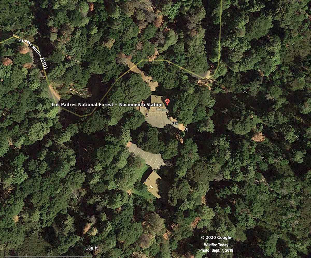
The Forest Service said the incident occurred while the personnel were defending the Nacimiento Station from the approaching fire.

The release from the Forest Service implied more than two of the 15 personnel may have been injured to some degree. Here is an excerpt:

A shelter deployment involving fifteen firefighters from the Dolan Fire occurred approximately at 0831 on Tuesday, Sept 8, 2020, in the vicinity of Nacimiento Station. These dedicated firefighters received injuries including burns and smoke inhalation while defending the Nacimiento Station on Dolan Fire on the Los Padres National Forest in California. Nacimiento Station was destroyed.

When a fixed wing aircraft mapped the Dolan Fire at 2 a.m. PDT September 8 about six hours before the incident, the fire was 74,591 acres, more than twice the size mapped the previous night when it was 36,213 acres. The heat sensing equipment detected intense heat at the fire’s edge at 2 a.m., 0.7 miles northwest of Nacimiento Station.

Fire shelters are small foldable pup tent-like fire resistant devices that a wildland firefighter can unfold and climb into if there is no option for escaping from an approaching inferno. Many firefighters have used the devices successfully, but others have been killed inside them.

Three days before, on September 5, three firefighters on the Bridger Foothills Fire northeast of Bozeman, Montana were forced to deploy and take refuge in their fire shelters when their safety became compromised by the proximity of the blaze, fire officials said.

Nacimiento Station
Nacimiento Station, satellite photo, September 7, 2018.

Thanks and a tip of the hat go out to Al and Tom.

100 more people rescued by helicopters as Creek Fire grows to over 140,000 acres

Helicopter pilot said it was, “By far the toughest flying I have ever done.”

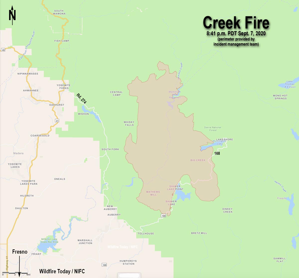
Map of the Creek Fire
Map of the Creek Fire at 8:41 p.m. PDT September 7, 2020.

The Creek Fire 22 miles northeast of Fresno grew explosively Monday, and has now blackened 143,929 acres.

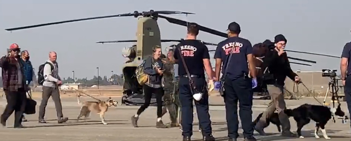
Military helicopters continue to rescue people that are becoming trapped as roads are blocked by the fast moving blaze. In addition to the 224 that were rescued by National Guard helicopters September 5 near Mammoth Pool Reservoir, about 100 more were rescued Monday night and Tuesday morning. The Guard and the U.S. Navy extracted people from the Edison Lake and China Peak areas and took them to the Fresno airport, the Fresno Bee reported. Helicopters that were transporting civilians included Blackhawks, Chinooks, and a Navy Seahawk.

Rescued people arrive at Fresno Creek Fire
People who were rescued from the Creek Fire by Chinook helicopters arrive at Fresno airport September 8, 2020. California National Guard image.

From the Bee, September 8:

Five flights have taken place Tuesday, according to Maj. Jason Sweeney, a spokesman for the California National Guard. More were imminent.

In the latest flights, a U.S. Navy Seahawk helicopter returned 17 people and a dog to Fresno from Edison Lake and a National Guard twin-rotor Chinook helicopter flew back from Edison with 46 people and four dogs. The Navy joined the efforts a short time later, sending a rescue helicopter from Lemoore Naval Air Station to Edison Lake, and returned with 11 people.

Not all of the attempts to rescue people were immediately successful. On some missions poor visibility caused by smoke forced pilots to abort and try again later.

(To see all articles on Wildfire Today about the Creek Fire, including the most recent, click HERE.)

One of the helicopter pilots who rescued people trapped in the fire said in an interview posted at the Bee that he has been shot at while flying for the Army but, “[T]he stress and added workload of going in and out of that fire every time is by far the toughest flying I have ever done.”

At least 65 structures have burned, according to CAL FIRE, and another 5,300 are threatened.

Resources assigned to the Creek Fire include 10 hand crews, 82 fire engines, and 7 helicopters for a total of 846 personnel.

In normal times if there was not competition for firefighting resources nationally due to numerous fires burning at the same time, there would be between 3,000 and 5,000 personnel on a fire this size. In the United States 23,018 are working on fires today, according to the National Interagency Coordination Center. As another example, the Bobcat Fire that is threatening the wildland-urban interface in the Los Angeles area has 85 total personnel and no hand crews three days after it started.

Tuesday’s weather forecast for the Shaver Lake area calls for 79 degrees, 14 percent relative humidity, and wind out of the northwest or north at 10 to 20 mph gusting at 15 to 28 mph — and no chance of rain. Conditions will moderate Tuesday night, and Wednesday will bring 71 degrees, 20 percent RH, and 5 to 8 mph winds out of the southwest.

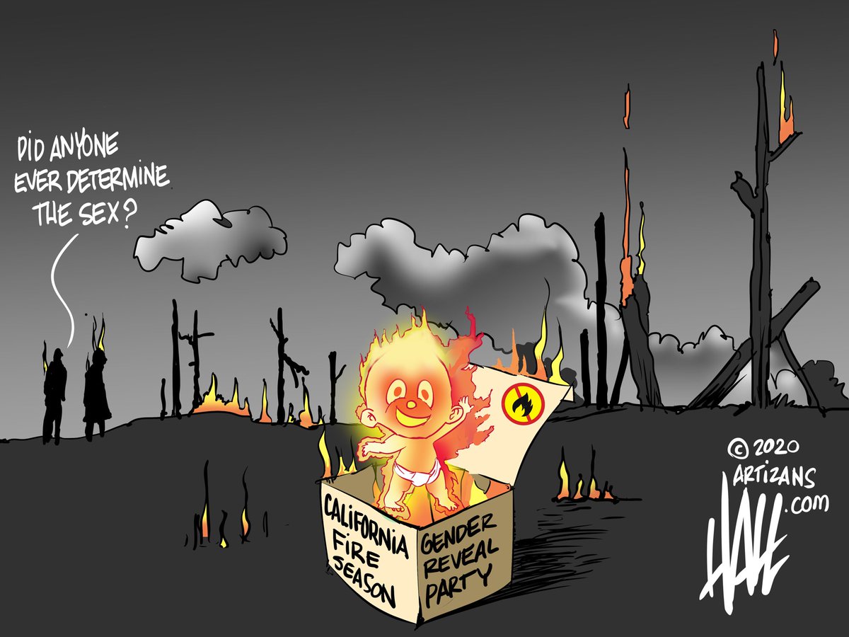
The 7,000-acre El Dorado Fire was started by a pyrotechnic device at a gender reveal party

Gender Reveal Halltoons
@halltoons. Used with permission.

Another large wildfire has been started by a pyrotechnic device at a gender reveal party. CAL FIRE determined that the El Dorado Fire which has burned over 7,000 acres near a heavily populated area of San Bernardino County in southern California was started by the use of a smoke generating pyrotechnic device. The intent was to produce pink or blue smoke to inform bystanders (waiting breathlessly nearby) about the gender of a fetus.

The fire began at 10:23 a.m. on September 5, 2020 in the El Dorado Ranch Park in Yucaipa. It spread from the park north to Yucaipa Ridge which separates Mountain Home Village and Forest Falls from the City of Yucaipa.

At least two other gender reveal parties that used pyrotechnic devices have started wildfires in recent years.

The 46,000-acre Sawmill Fire southeast of Tucson, Arizona was ignited in 2017 by an off-duty Border Patrol agent. He mixed colored powder into a Tannerite exploding target which would show blue or pink smoke when shot with a rifle, according to his attorney, Sean Chapman. The target exploded as planned and started what became the Sawmill Fire. A witness helpfully recorded a video of the explosion.

In 2020 a gender reveal party in Florida went wrong and sparked a 10-acre fire, also caused by a Tannerite exploding target.

El Dorado Fire
El Dorado Fire, photo by Jeff Zimmerman Sept. 5, 2020.

Bobcat Fire prompts evacuation of Mt. Wilson in southern California

Santa Ana winds predicted for Tuesday could cause the fire to endanger structures in foothill communities. Evacuation warnings have been issued.

Updated September 8, 2020  |  10:07 a.m. PDT

map of the Bobcat Fire
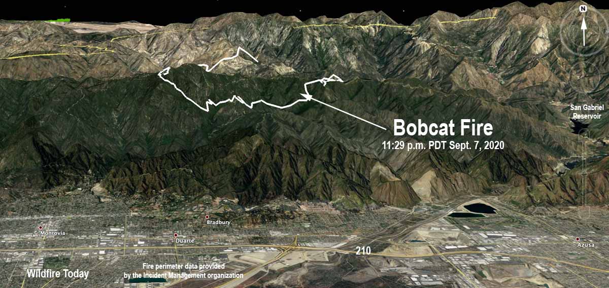
3-D map of the Bobcat Fire looking north at 11:29 p.m. PDT September 7, 2020.

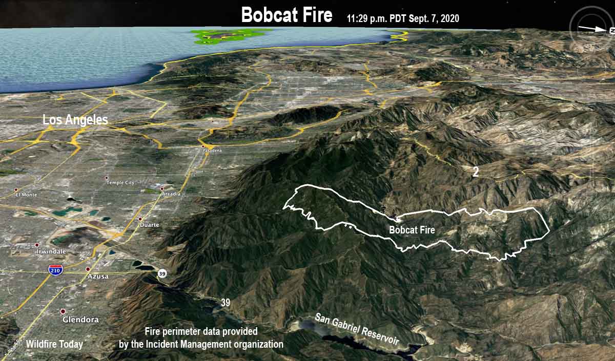
The Bobcat Fire in the Angeles National Forest north of Monrovia and Duarte in southern California grew on Monday to 8,553 acres.

Evacuation warnings (be ready to evacuate if necessary) have been issued for some communities in the foothills.

map of the Bobcat Fire
3-D map of the Bobcat Fire looking west at 11:29 p.m. PDT September 7, 2020.

The weather forecast predicts strong northeast winds which could cause the fire to spread much more quickly.  The strongest winds are expected Tuesday night and Wednesday morning with gusts between 35 and 55 mph with isolated gusts around 60 mph. Relative humidity will drop into the teens and single digits Tuesday afternoon with little or no recovery (or increase) Tuesday night and Wednesday.

(To see all articles on Wildfire Today about the Bobcat Fire, including the most recent, click HERE.)

A Red Flag Warning is in effect Tuesday through Wednesday for all areas of Ventura and Los Angeles counties, except for the Antelope Valley.


September 7, 2020 | 8:14 p.m. PDT

map Bobcat Fire
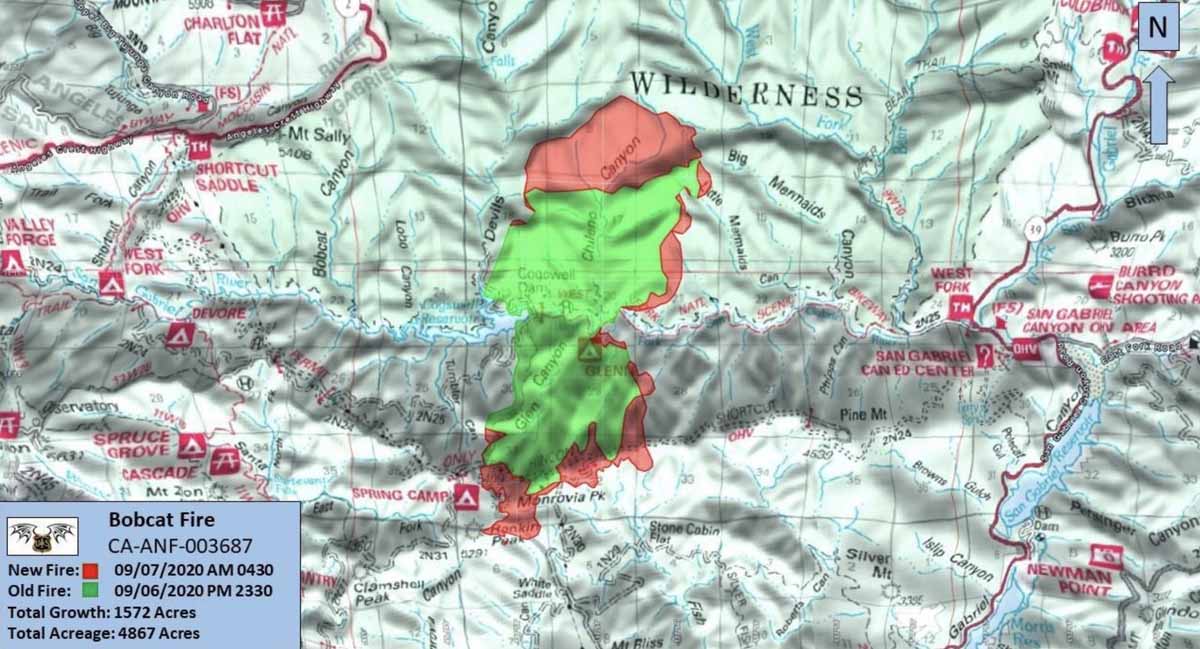
Official map of the Bobcat Fire at 4:30 a.m. PDT Sept 7, 2020. Produced by the Angeles National Forest.

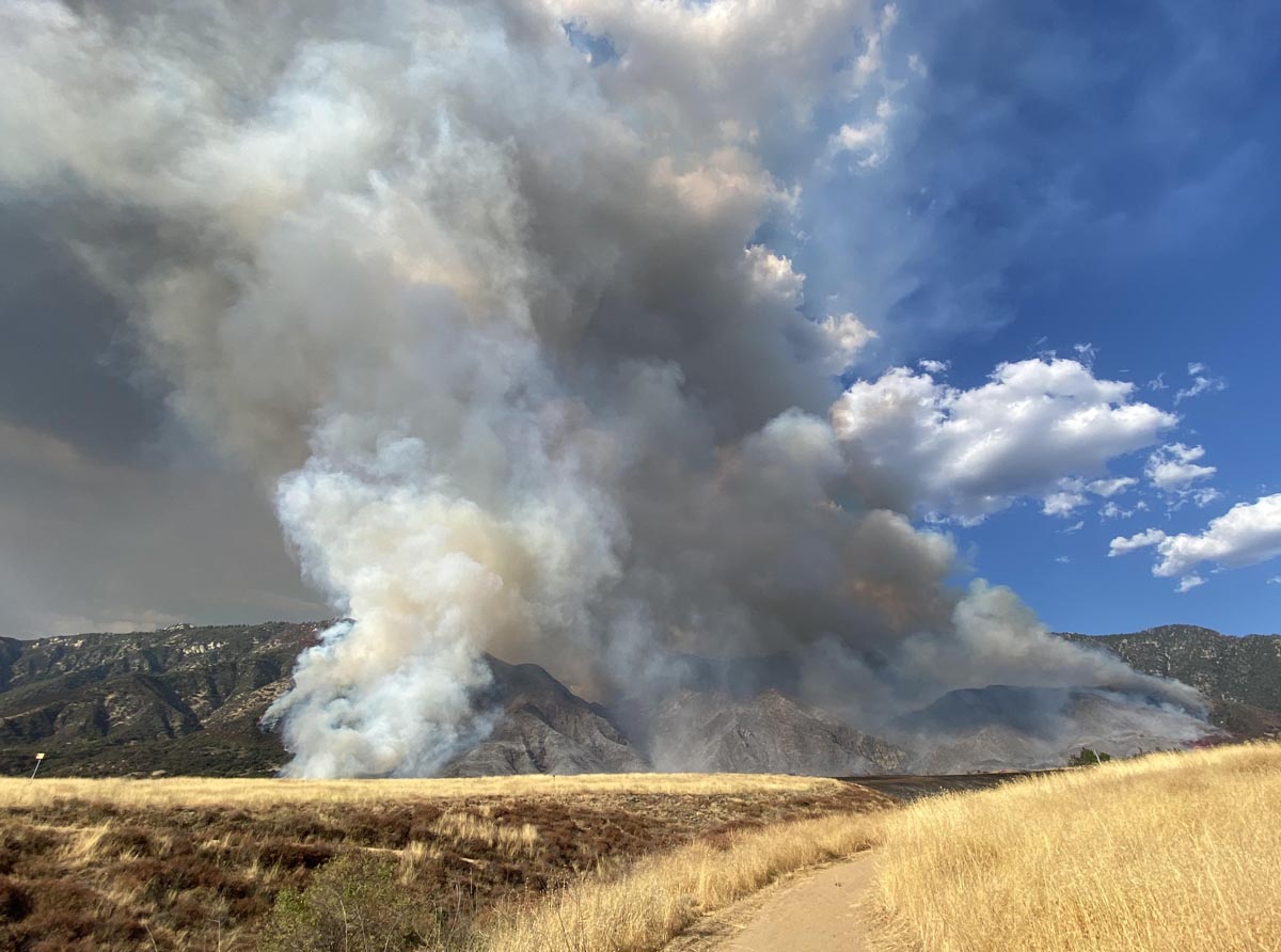
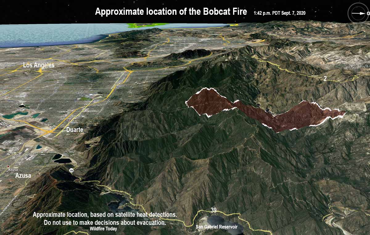
The Bobcat Fire that started in a canyon north of the Los Angeles area has spread south to the ridgetop above the Los Angeles basin cities of Monrovia and Duarte, prompting the evacuation of the Mt. Wilson Observatory and multiple campgrounds. Fire authorities said Monday morning the fire had burned 4,871 acres.

The weather forecast for Santa Ana winds on Tuesday and Wednesday is troubling, and predicts 20 mph northeast winds gusting to 35 mph at the higher elevations beginning by noon Tuesday. The forecast is unclear about the winds in the lower elevations, but strong northeast winds could cause the spread of the Bobcat Fire to increase. It is likely, a meteorologist said, that a Red Flag Warning will be issued for Tuesday and Wednesday.

Kris Ankarlo, a reporter for KFIAM640, said fire authorities warned in a Monday afternoon press conference that foothill communities should plan for possible evacuation if the Santa Winds align with the foothill canyons and push the fire into the wildland-urban interface.

The blaze started with a rapid rate of spread on September 6 at 12:21 p.m. near the Cogswell Dam and West Fork Day Use area in heavy fuels.

Monday morning the resources assigned included 5 engines, 3 hand crews, 4 helicopters, 5 fixed-wing aircraft, and 2 water tenders for a total of 101 personnel. For a wildfire in southern California with tremendous potential, these numbers are a very small fraction of what you would normally see on the second day, and speaks to the serious competition for resources needed to combat the fires in California.

Bobcat Fire
APPROXIMATE LOCATION of the Bobcat Fire. Looking west toward the Pacific Ocean 1:42 p.m. PDT September 7, 2020. Do not use to make evacuation or any other decisions. The map is based on heat detections from satellites.

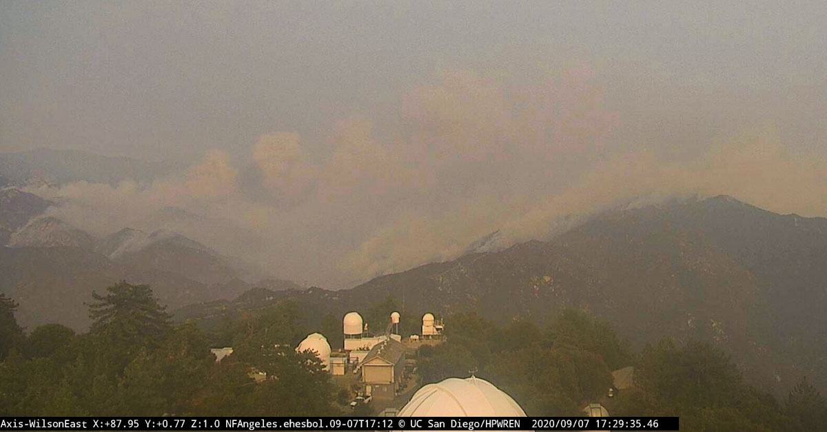
Smoke in the area Monday afternoon likely made it difficult to operate firefighting aircraft, including air tankers and helicopters.

Bobcat Fire
The Bobcat Fire. Looking east from Mt. Wilson at 5:29 p.m. PDT September 7, 2020. The iconic observatories can be seen in the foreground.

In an action that has not occurred in recent memory, based on fire and weather conditions the U.S. Forest Service ordered the closure of seven National Forests in California: Angeles, San Bernardino, Cleveland, Los Padres, Inyo, Sequoia, Sierra, and Stanislaus.