Study found hazardous air quality conditions at fire camps in Oregon and California

Smoke exposure levels at the Creek Fire ranged from hazardous to unhealthy for 30 days

(From Bill: Wildland firefighters and people who live in areas where long-term fires are common, such as Northern California and the Northwest, know that smoke can persist for days or weeks and can cause or aggravate respiratory and other medical issues. But knowing it exists and having peer reviewed quantifiable data proving it is hazardous to health, are two different things. Science like this could lead to changes that may benefit firefighters and the general public.)


In September and October the Centers for Disease Control and Prevention (CDC) deployed two staff members to serve as air resource advisors at wildfires in Oregon and California.

Air resource advisors were fully integrated into the wildfire incident management teams to provide insights into understanding and predicting smoke exposure levels. The individuals interacted with stakeholders, including air quality regulators, fire personnel, public health practitioners, and community residents. A primary aspect of this engagement was to forecast smoke levels for areas immediately affected by fires and generate a daily smoke outlook to keep stakeholders informed about prevailing smoke levels. 2020 is the first year during which the CDC worked with the Interagency Wildland Fire Air Quality Response Program and deployed staff members as air resource advisors for wildfire incidents.

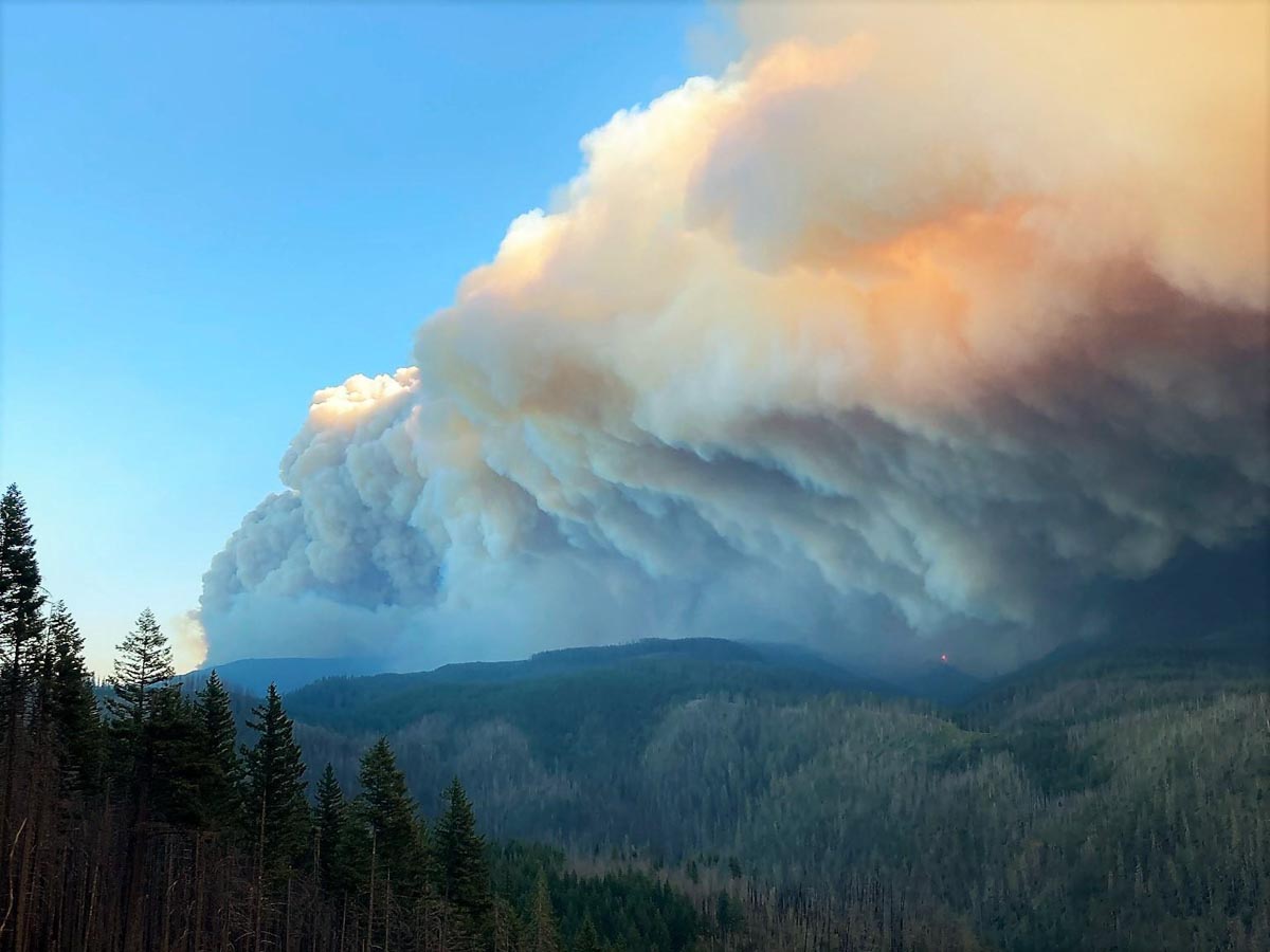
From August 31 to September 14, 2020, one CDC staff member supported wildfires in central Oregon’s Cascade Range east of Sisters, which included the Beachie Creek, Holiday Farm, Lionshead, and Riverside fires. Strong east winds across the Cascade Mountains resulted in more than 560,000 acres of fire growth from September 7 through 10.

satellite photo fires smoke Washington, Oregon, and California
GOES-17 photo of smoke from wildfires in Washington, Oregon, and California at 5:56 p.m. PDT Sept. 8, 2020. The photo was taken during a very strong wind event.

Another CDC staff member was deployed to the Creek Fire from September 20 to October 5, 2020. This fire near North Fork, California started September 4 and grew to 193,000 acres during its first week; as of December 3, 2020, the fire had burned 379,895 acres.
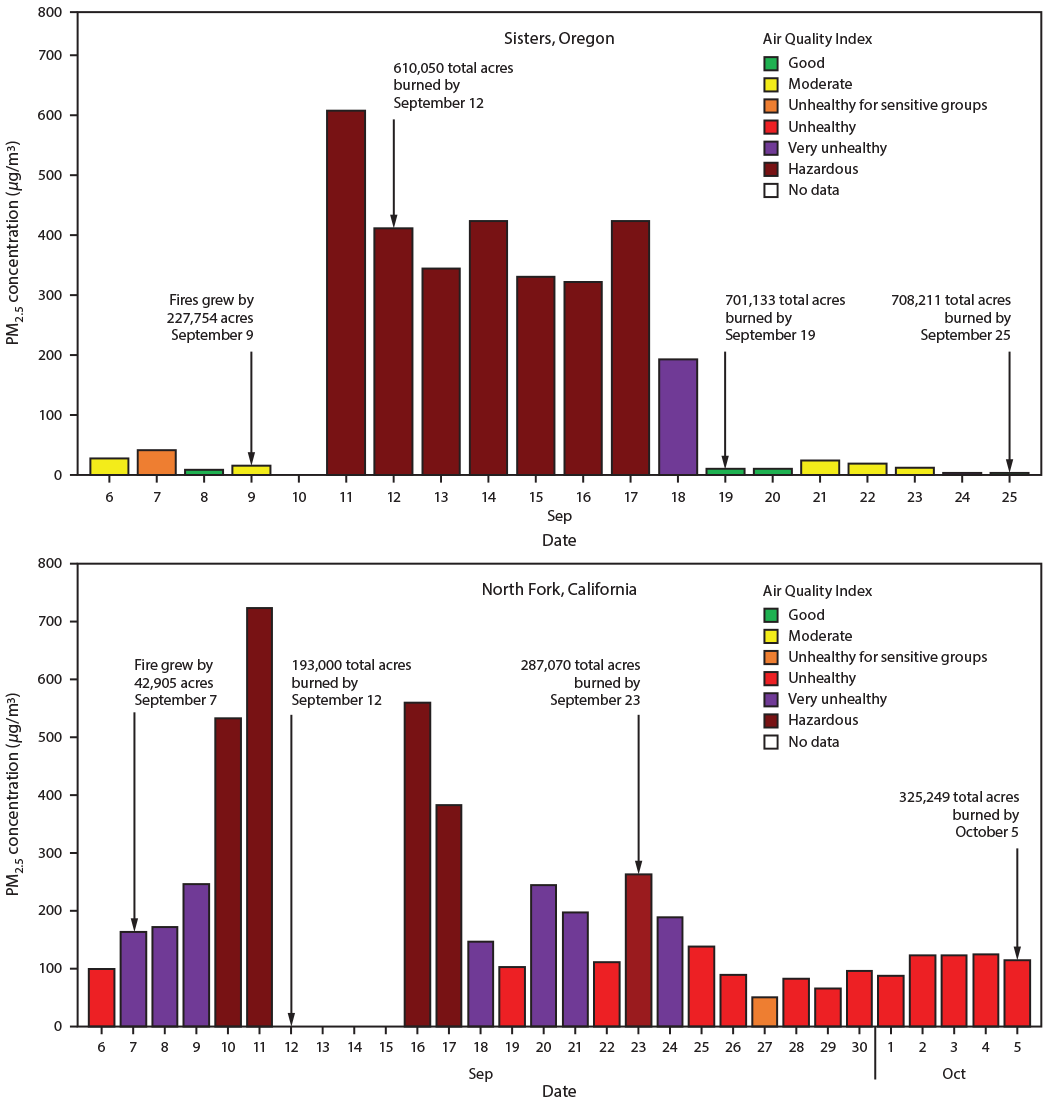
Air quality study, fire camps, 2020
Abbreviation: PM2.5 = particles with aerodynamic diameters ≤2.5 μm.
       * Sensitive groups include persons aged ≤18 years; adults aged ≥65 years; pregnant women; persons with chronic health conditions such as heart or lung disease, including asthma and diabetes; outdoor workers; persons experiencing homelessness, and those with limited access to medical care. (https://www.cdc.gov/air/wildfire-smoke/default.htm).
       † Fire camps typically offer logistical support to the wildfire suppression operation by providing firefighters and incident personnel sleeping locations (camping), morning and evening meals, workspaces, and administrative services.
       § The monitoring instrument in North Fork, California, recorded errors and did not report data during September 12–15, 2020.
       ¶ Start date of Creek Fire in California was September 4. Start dates of fires in Oregon were as follows. Lionshead was August 16; Beachie Creek was August 16; Holiday Farm was September 7; Riverside was September 8.

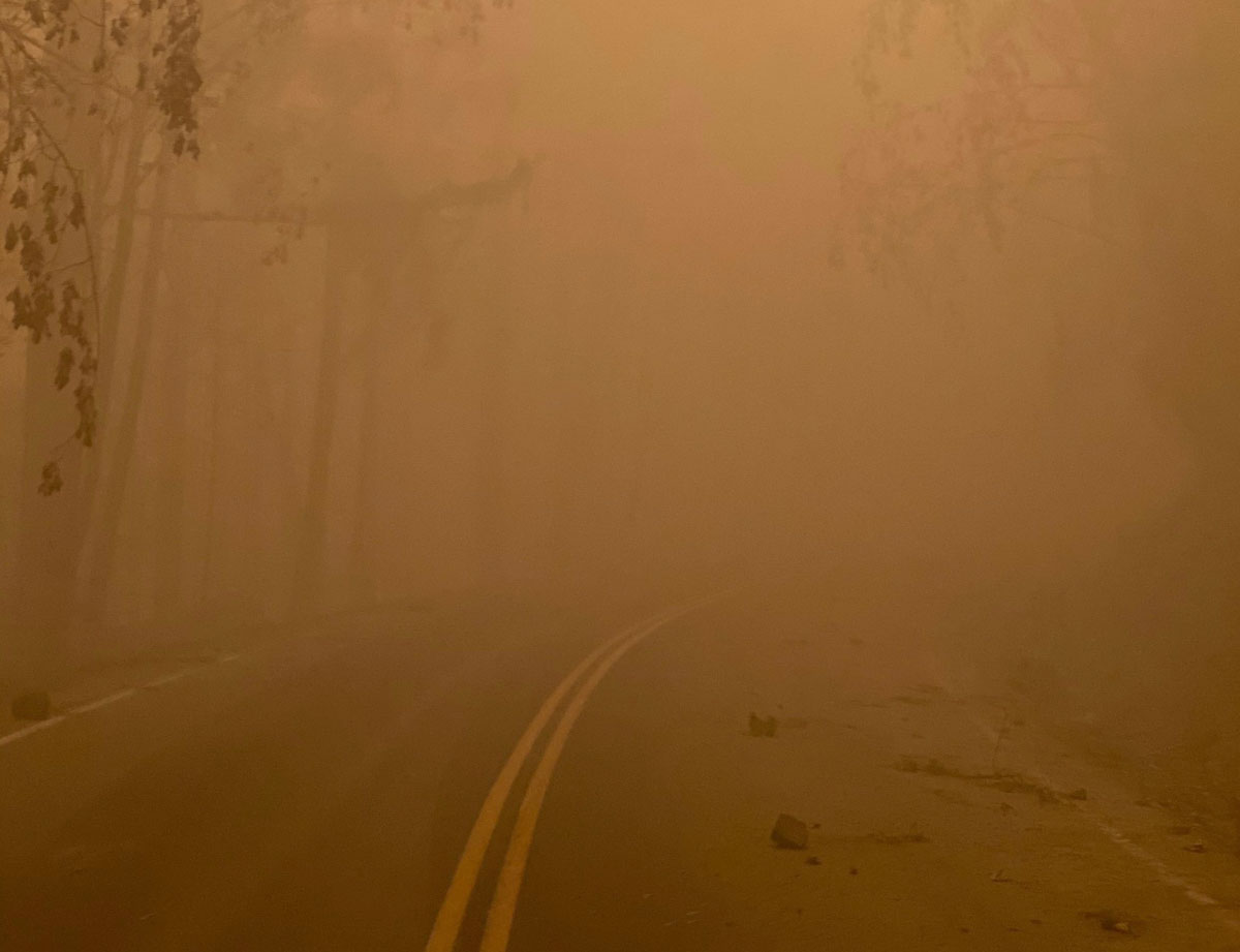
During these two deployments, several public health concerns came to light. Of note, although smoke from wildfires drifted long distances and affected downwind communities, the brunt of poor air quality was observed in communities adjacent to wildfire incidents. For example, communities near the fires in California and Oregon experienced high concentrations of PM2.5, as measured by air quality monitors, resulting in “Unhealthy” to “Hazardous” conditions, as defined by the U.S. Environmental Protection Agency Air Quality Index.

Fire personnel who camped and rested between work shifts at nearby fire camps (North Fork, California and Sisters, Oregon) were also exposed to poor air quality levels. These fire camp exposures contribute to higher overall cumulative smoke exposure and, along with other occupational risk factors such as fatigue and stress, could limit recovery that is much needed for fire personnel while away from the active fire perimeter. In addition, environmental hazards such as extreme heat and higher concentrations of ambient carbon monoxide were prevalent during days with heavy smoke and after extreme fire growth days. These hazards added a layer of complexity to fire response efforts and might have limited fire personnel recovery between work shifts.


From: Navarro K, Vaidyanathan A.  — Notes from the Field: Understanding Smoke Exposure in Communities and Fire Camps Affected by Wildfires— California and Oregon, 2020. MMWR Morb Mortal Wkly Rep 2020;69:1873–1875. DOI: http://dx.doi.org/10.15585/mmwr.mm6949a4

Thanks and a tip of the hat go out to Bob.

Now that the extreme weather has moderated, firefighters beginning to make progress on fires in northwest Oregon

Map of fires in northwest Oregon, September 13, 2020 Riverside Beachie Creek Lionshead
Map of fires in northwest Oregon, September 13, 2020.

Lionshead Fire

Of the three very large fires south of Portland, Oregon the 138,718-acre Lionshead has been the most active in the last 24 hours, with most of the growth occurring on the northeast and southeast sides. Crews continue to secure and protect property and conduct damage assessments as fire activity, smoke, and other hazards allow. Wildfires have not burned in the area for many decades, which has resulted in heavy layers of fuel on the ground that firefighters must work through to construct fireline and mop up, a very laborious and time-consuming process.

Resources assigned to the fire include 51 hand crews, 62 engines, and 10 helicopters for a total of 1,482 personnel.

Air quality on the Lionshead Fire
Air quality on the Lionshead Fire, Sept 11, 2020. InciWeb photo.

Riverside Fire

On the Riverside Fire dozers completed a line around spot fires on the west side to help secure the areas closest to the communities of Estacada and Molalla. On Sunday crews were working on the north side above the North Fork Reservoir, looking at opportunities to move towards the east. Firefighters are using two unmanned aerial systems (UAS, or drones) to assess fire conditions from the air. Helicopters are flying when visibility allows.  The blaze has burned 53 structures at last count, and 133,799 acres, and is still a mile away from the Beachie Creek Fire. Resources assigned to the fire include 8 hand crews, 11 engines, and 3 helicopters for a total of 315 personnel.

“You’ll start in the coming days to see some lines showing containment” on the Riverside fire said Alan Sinclair, incident commander for the Type 1 incident management team. “We’re having a little bit more favorable weather and things are coming together.”

Riverside Fire
Riverside Fire, from La Dee Flats September 9, 2020. InciWeb photo.

Beachie Creek Fire

Fog slowed activity of the fire and firefighters on the 188,374-acre Beachie Creek Fire Sunday. After it dissipated firefighters resumed work on the perimeter and accessing damage to structures. Crews and heavy equipment are tying in the control lines on the west and northwest sides. The Beachie Creek and the Riverside Fires remain about one mile apart. Resources assigned to the fire include 11 hand crews, 45 engines, and 7 helicopters for a total of 563 personnel.

Three Area Command Teams (ACT) were mobilized Thursday to assist local units in suppressing the fires in the western states. One of them, led by Area Commander Joe Stutler, will be coordinating the efforts in northwest Oregon. The other two will be California.

Oregon fires have burned about a million acres

An Area Command Team has been mobilized to assist local units in the state

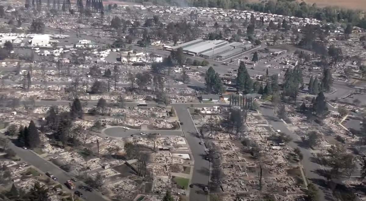
structures burned Almeda Fire Phoenix Talent Oregon
Devastation from the Almeda Drive Fire in the area of Phoenix and Talent in southern Oregon. Screenshot from video shot by Jackson County on September 8, 2020.

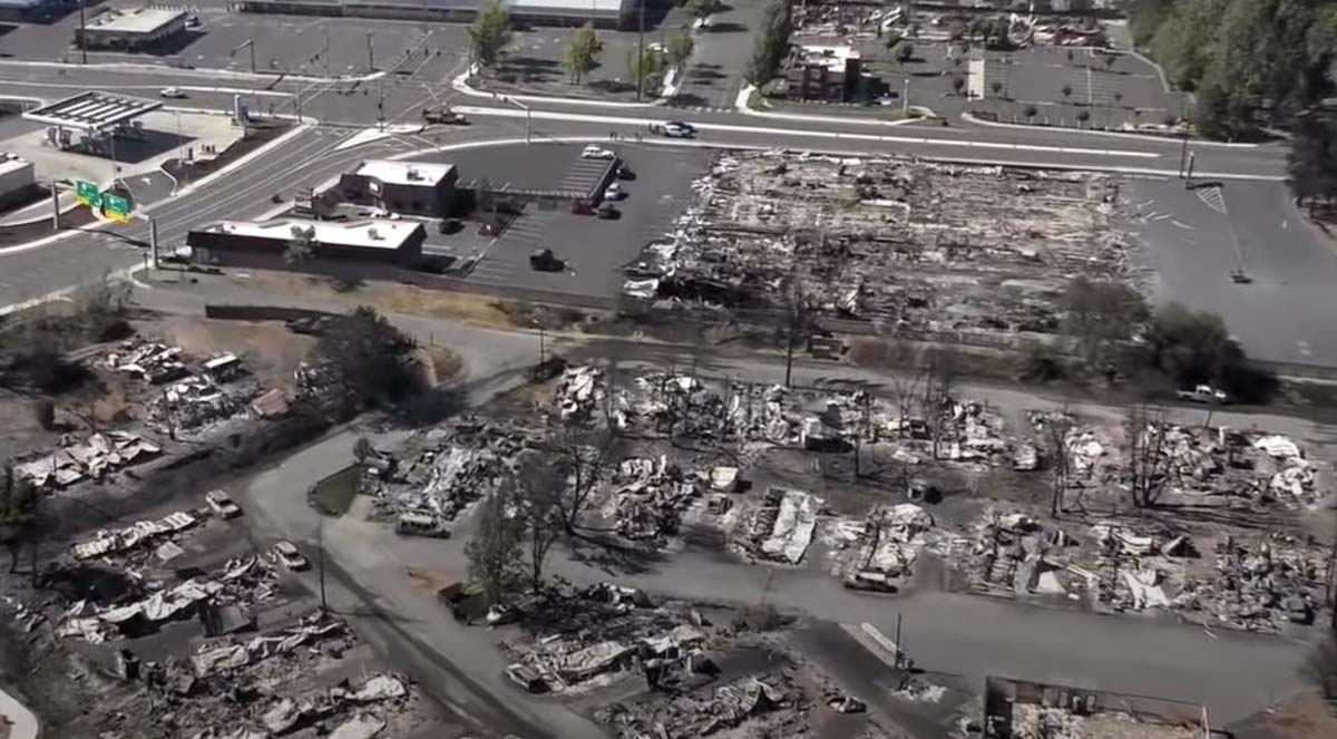
It could take some time to count all of the structures that have burned in western Oregon. What is known so far about the huge fires that have burned approximately a million acres in the state is the deaths of seven people have been documented according to state officials. Dozens more, they said, are unaccounted for, but many of those could be safe and are having difficulty communicating with friends and relatives.

The number of people that have evacuated has been fluctuating wildly. The Oregonian reported that the state in a news release Thursday night said an “estimated 500,000 Oregonians have been evacuated and that number continues to grow.” The half-million figure received widespread attention, but after an analysis by the newspaper determined that number could not be accurate, Gov. Kate Brown acknowledged Friday the true number to be far lower, about 40,000. She explained that the higher figure included everyone in some category of evacuation, including “Be Set,” and “Be Ready.”

Map heat wildfires western U.S.
Map of heat detected on wildfires in the western U.S. by satellites September 12, 2020.

The weather next week is expected to be cooler, with decreasing winds and a slight chance of rain on Tuesday and Thursday. This should slow the spread of the blazes and enable firefighters to shift from evacuations to constructing fireline on the perimeters. Up until now, a very, very small percentage of the edges of the fires have containment line.

Doug Grafe, chief of fire protection at the Oregon Department of Forestry, said eight of the large fires “will be on our landscape until the winter rains fall. Those fires represent close to 1 million acres … We will see smoke and we will have firefighters on those fires up until the heavy rains.”

Three Area Command Teams (ACT) were mobilized Thursday to assist local units in suppressing the fires in the western states. One of them, led by Area Commander Joe Stutler, will be coordinating the efforts in northwest Oregon. The other two will be California.

Typically an ACT is used to oversee the management of large incidents or those to which multiple Incident Management Teams have been assigned. They can take some of the workload off the local administrative unit when they have multiple incidents going at the same time. Your typical Forest or Park is not usually staffed to supervise two or more Incident Management Teams fighting fire in their area. An ACT can provide decision support to Multi-Agency Coordination Groups for allocating scarce resources and help mitigate the span of control for the local Agency Administrator. They also ensure that incidents are properly managed, coordinate team transitions, and evaluate Incident Management Teams.

structures burned Almeda Fire Phoenix Talent Oregon
Devastation from the Almeda Drive Fire in the area of Phoenix and Talent in southern Oregon. Screenshot from video shot by Jackson County on September 8, 2020.
Satellite photo smoke wildfires
Satellite photo showing smoke from wildfires at 5:17 p.m. PDT September 11, 2020.

Why did the Oregon fires in the Siege of ’20 spread so quickly?

Using a rule of thumb to predict how fast a wildfire will spread

September 10, 2020 | 9:42 p.m. PDT

Hot-Dry-Windy Index
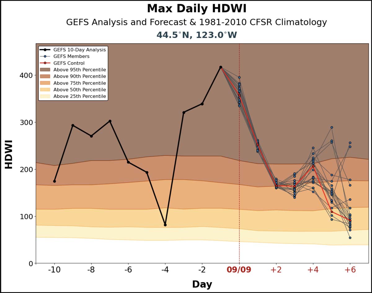
Hot-Dry-Windy Index for Oregon’s Willamette Valley, calculated for September 9, 2020. Day -2 is the actual HDWI for September 7, the day of the wind event in Oregon.

People may wonder why all of a sudden there were numerous very large fires in Oregon this week during what I am calling the Siege of ’20.

To a degree it didn’t exactly happen suddenly; some of the fires had been burning for weeks. Two of the largest, the Beachie Creek and Lionshead Fires, started from lightning on August 16.

The fires in Oregon were all heavily influenced by a historic extreme wind event on Monday, September 7 that brought 25 to 50 mph winds to many areas. Power lines and trees were toppled and any existing fires or just a spark could escalate into a raging fire quickly. Four fires east of Interstate 5 from Portland south to Eugene are each now larger than 100,000 acres. Just one 100,000-acre fire in Oregon is rare, but to have four at once is unprecedented in recent decades.

These fires and others in Oregon, California, and Colorado are crying out for firefighters, engines, helicopters, and air tankers but the fire suppression infrastructure available falls far short of the present need. This means that after the wind subsides, putting the blazes out quickly is not realistic. But when fires are moving with a strong wind, nothing can be done to stop them. Wednesday in southern California thousands of residents were under evacuation warnings due to the Bobcat Fire that was threatening seven high density communities in the wildland-urban interface of the Los Angeles area. Firefighters were only able to get access to one water-dropping helicopter, and for just part of the day. Normally there would have been a dozen helicopters assisting firefighters. 

Drought Index September 1, 2020
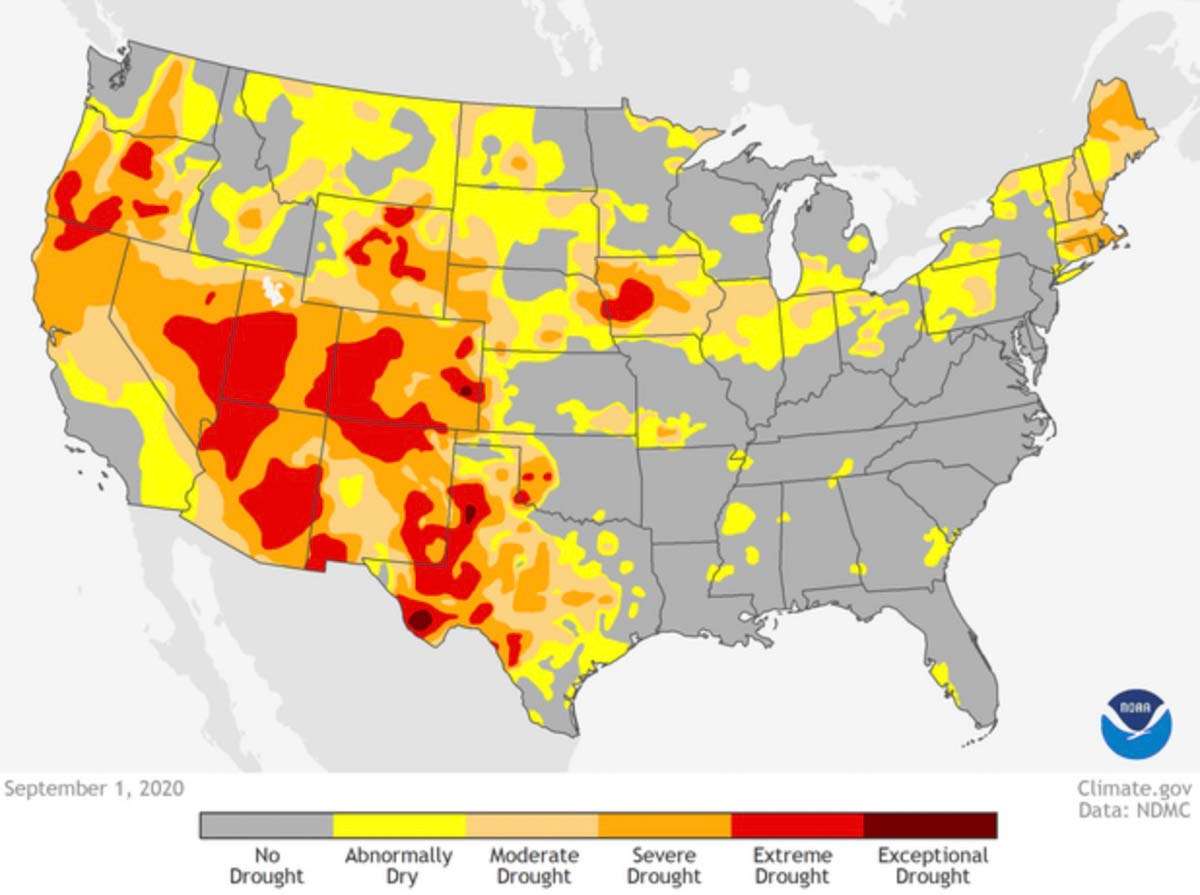
Drought Index September 1, 2020.

It was not just the extreme wind in Oregon and the shortage of firefighting resources that caused the fires to grow so quickly. Much of the state is in severe to extreme drought along with Nevada, Arizona, and Colorado. The northern two-thirds of California is in moderate to extreme drought and there has been little rain in many of these areas during the last two months. This results in the moisture content of the vegetation (or fuel) being low, making it more receptive to igniting and burning more quickly and intensely than if conditions were closer to average.

When fires are burning in vegetation that has not been visited by fire for decades, the amount of biomass and dead material that has accumulated increases the intensity of a fire as well as its resistance to control — literally adding fuel to the (next) fire. The areas where the four megafires are burning in the Cascade Mountain Range east of Interstate 5 have virtually no recorded history of fires.

The three components that dictate how a wildfire burns are weather, fuel (vegetation), and topography. There is one subcategory of weather that outranks all of the other factors for the amount of influence it has on how rapidly a fire moves — wind. Sophisticated models run on computers can calculate the projected rate of spread of a vegetation fire, or you could use the rule of thumb which works surprisingly well when you have dry fuels and strong winds. That “rule” says, the rate of spread of a fire is roughly equal to 10 percent of the average wind speed measured in an open area. Researchers have studied this. But keep in mind there are MANY variables that affect the spread of a fire, so this thumb rule is just a wild-ass guess, but it can be a starting point to get an idea of how fast a fire can move when it’s windy.

Using the rule of thumb on the fires that spread exponentially on September 7 in Oregon, if there was an average wind speed of 25 mph, that would spread a fire at about 2.5 miles each hour.

Here are more facts about the conditions that contributed to the Siege of ’20.

The Hot-Dry-Windy Index (HDW) on September 7 (see chart above) was well above the 95th percentile. It was much hotter, drier, and windy than average for the date and location, which means the conditions favored the rapid spread of fires. The HDW is very simple and only considers the atmospheric factors of heat, moisture, and wind. To be more precise, it is a multiplication of the maximum wind speed and maximum vapor pressure deficit (VPD) in the lowest 50 or so millibars in the atmosphere. The products, displayed as charts, show the index for the preceding 10 days and the forecast for the next 7 days.

100-hour Time Lag Fuels
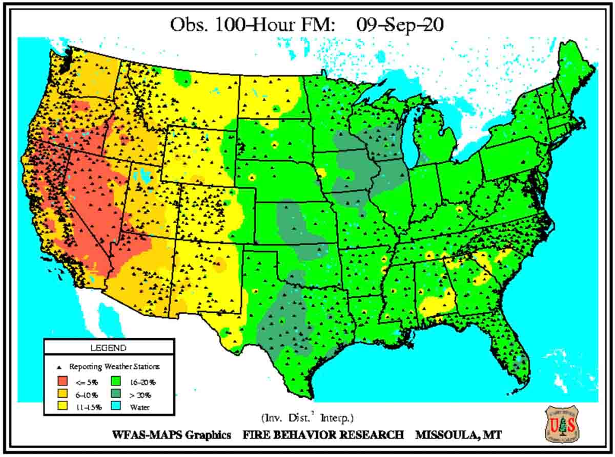
Weather observations, 100-hour Time Lag Fuels, September 9, 2020.

Dead vegetation absorbs moisture from humid air, or dries out when the humidity is low, and this affects the rate of spread of a wildfire. The moisture content of the dead vegetation in Oregon this week, the 100-hour time lag fuel (1″ to 3″ in diameter), has been low; less than 10 percent, and in some areas, below 5 percent. The lower the fuel moisture, the faster a fire spreads. Kiln-dried lumber is usually at about 12 percent.

If you read these 800 words, congratulations! Send us a check for $50 and and you’ll receive a Continuing Education Credit. (kidding)

Wildfires have burned over 800 square miles in Oregon

Four fires east of Interstate 5, from Portland south to Eugene, are each larger than 100,000 acres.

map fires Oregon Portland
Map showing heat detected by satellites within the last 24 hours on fires in the Portland-Eugene area, Sept 10, 2020.

At least 50 fires have burned over 800 square miles in Oregon, and again on Wednesday, dry, breezy weather kept them growing.  Governor Kate Brown said that during this fire siege the state will likely experience the greatest loss of property and lives from wildfires in its history. This a result of the confluence of several factors, including drought and lightning, along with hot, dry, and very windy weather.

The Oregon Office of Emergency Management has created an interactive website to help provide information about evacuations statewide.

The Beachie Creek Fire 17 miles east of Salem started August 16. On September 6 it was 469 acres but the historic wind storm the next day caused it to grow overnight to 131,000 acres. On September 9 it was mapped at 182,000 acres and was 19 miles east of Salem. Fire personnel had to evacuate their incident command post after electrical lines and transformers were destroyed during the wind event. An update from the incident management team on September 9 said “mass evacuations are being planned”. The east side of the Beachie Creek Fire has merged with the Lionshead Fire. The fire organization has a Facebook page with evacuation information.

The 109,223-acre Lionshead Fire started August 16 on the Confederated Tribes of Warm Springs Reservation 14 miles west of the Warm Springs community and has spread to the Willamette National Forest merging into the east side of the Beachie Creek Fire. It is actively growing on the west side of the Cascades. Long range spotting contributed to the fire spreading for 12 miles reaching areas near Breitenbush and Detroit Lake. The fire also crossed highway 22 in multiple places.  More information can be found on Facebook.

The Holiday Farm Fire, also known as the McKenzie Fire, has burned 144,694 acres about 14 miles east of Eugene. Evacuations are in effect; the Lane County government and  Linn County Sheriff’s office has more information. On Wednesday fire behavior and weather conditions were still treacherous and kept firefighters from accessing many areas, but they were able to protect some structures by burning out around them to remove flammable vegetation. Winds on Thursday are expected to shift and begin blowing out of the west and relative humidity is expected to be in the low teens.  These weather conditions may contribute to another day of very active fire behavior.

The 120,000-acre Riverside Fire is southeast of both Oregon City and Portland. Most of the spread in the last 24 hours was on the southwest and northwest sides. The blaze moved four miles down the Clackamas River corridor towards the communities of Estacada and Springwater. Crews worked overnight to continue point protection efforts on homes and other critical infrastructure in that area and along Highway 211. On Thursday firefighters hope to take advantage of predicted lighter winds during the afternoon to conduct critical air operations. However, changing wind directions throughout the day could spur additional fire growth in multiple directions. Thursday morning fire officials estimated it was approximately two air miles from the community of Estacada, Oregon. The Clackamas County Sheriff’s office has information about evacuations that are in effect.

The Echo Mountain Complex has burned 2,297 acres south and east of Otis at the intersection of Highways 101 and 18. Evacuations are in effect. It is burning on both the north and south sides of 18. The Oregon Department of Forestry reports that local firefighters and ODF personnel have been out in force around the clock on the fire lines, but outside help is very limited due to the large number of fires across the state. Matt Thomas of ODF said Wednesday there has been no containment yet, and that may not happen for an extended period of time. More information is on the ODF’s West Oregon District Facebook Page.

Strong winds spread numerous wildfires in Oregon and Washington

An unprecedented number of fires and acres have burned in recent days

September 8, 2020 | 9:23 p.m. PDT

satellite photo fires smoke Washington, Oregon, and California
GOES-17 photo of smoke from wildfires in Washington, Oregon, and California at 5:56 p.m. PDT Sept. 8, 2020.

The number of wildfires and acres burning in Washington and Oregon are reaching a level that is close to unprecedented in recent memory.

Tuesday afternoon the western one-quarter of Oregon was inundated with dense smoke from multiple fires south of Portland and mostly east of Interstate 5. Strong winds are turning small fires that were ignited weeks ago in Marion County, Oregon into major incidents as law enforcement officers and firefighters try to stay ahead of the fires evacuating residents in their paths.

map wildfires in Washington and Oregon
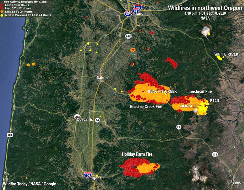
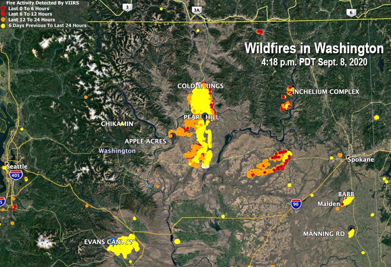
Map showing heat detected by satellites on wildfires in Washington and Oregon at 4:18 p.m. PDT September 8, 2020.

Thousands of Oregonians were under evacuation orders Tuesday. OPG.org reported that officials said they were so focused on protecting lives and property that suppressing the blazes consuming hundreds of thousands of acres would have to wait. “Our number one priority is evacuation and basic life safety,” said Mariana Ruiz-Temple, chief deputy state fire marshal. “This wind event does not give us the opportunity to really get in there and fight fire how we might fight fire in previous events.”

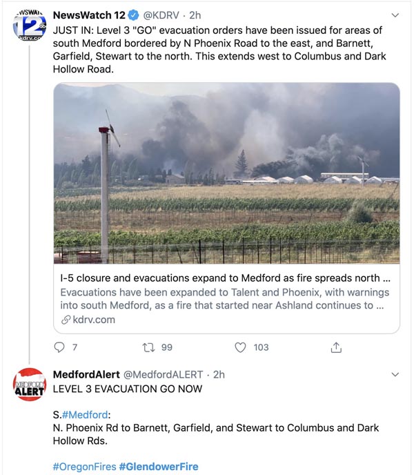
The Glendower Fire started north of Ashland, Oregon then spread northwest along the Interstate 5 corridor into Medford. Much of the city is under evacuation orders and multiple structures have burned. (More information about the Glendower Fire, including a map.)

Glendowner Fire Oregon Medford
Tweet at 7:04 p.m. PDT Sept 8, 2020.

Strong winds accompanying a cold front was the primary force responsible for the rapid spread of the fires, but some of the driest conditions seen in decades led to low moisture content in vegetation that made large quantities of fuel available to quickly ignite.

map wildfires in northwest Oregon
Map showing heat detected by satellites on wildfires in northwest Oregon, south of Portland at 4:18 p.m. PDT September 8, 2020.

The New York Times reported the National Weather Service on Tuesday placed Northwest and southwestern Oregon under an extreme fire danger warning, the first time southern Oregon has been the subject of such a warning, according to the Oregon Climate Office. The Oregon Department of Corrections evacuated 1,450 inmates from three prisons east of Salem.

The New York Times:

Gov. Jay Inslee of Washington said on Tuesday that an estimated 330,000 acres had burned across the state on Monday, more than what burned in each of the last 12 fire seasons. “The devastation is all over our state,” Mr. Inslee said in a news briefing.

One of the smaller fires in Washington, relatively speaking,  wiped out about 80 percent of the structures in Malden, a town of 200 people south of Spokane. Officials said the buildings that burned included the fire station, post office, city hall, and the library.

Three of the largest blazes in Washington are Cold Springs south of Omak (163,000 acres), Pearl Hill east of Brewster (174,000 acres), and Evans Canyon north of Yakima (75,817 acres). The Pearl Hill fire reportedly burned 170,000 acres within 24 hours.

map fires Washington
Map showing heat detected by satellites on wildfires in Washington at 4:18 p.m. PDT September 8, 2020.