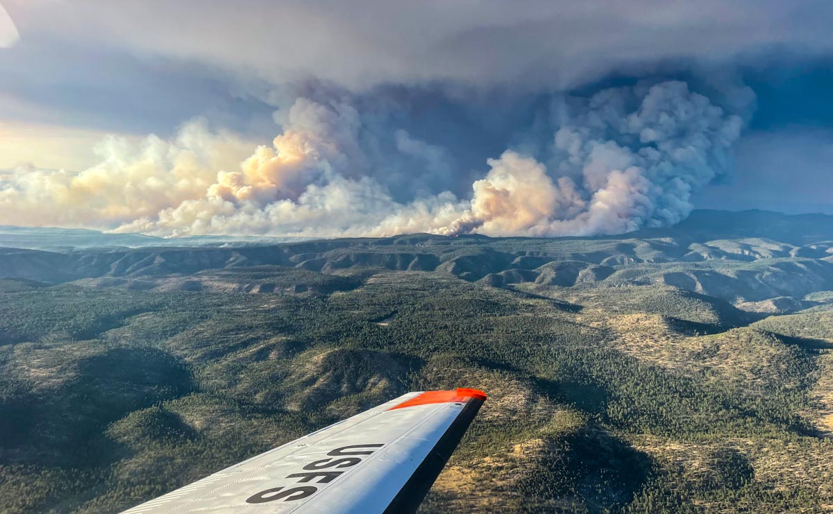
Black Fire in New Mexico, as seen from the USFS Lead Plane. Possibly May 16, 2022.
The Black Fire 31 miles north-northeast of Silver City, New Mexico is very active Monday afternoon, as seen in these photos.
Smoke plume from Black Fire at 3:51 p.m. MDT May 16, 2022. NOAA satellite image.
10:22 a.m. MDT May 16, 2022
Black Fire. Photo from a firefighting aircraft, May 15, 2022.
The Black Fire 31 miles north-northeast of Silver City, New Mexico made an impressive run to the east Sunday. Fire officials said that morning it was 1,174 acres; when it was mapped by an aircraft that night at 9:04 it had grown to 18,762 acres and was 11 miles long. Satellite data at 3:26 Monday morning indicated that it had continued to spread vigorously to the east through the night.
It is burning in timber and tall grass in the Gila National Forest 34 miles west of Interstate 25 and Truth or Consequences.
Black Fire map at 9:04 p.m. May 15, 2022. The fire continued moving east after it was mapped.
The rapid growth of the fire Sunday was due to dry fuels, relative humidity that dropped to 2 percent, and 10 mph winds gusting to 22 out of the west-southwest. The data was recorded at the Gila Center weather station.
The weather forecast for Monday near the fire at 6,800 feet calls for 18 mph winds gusting out of the southwest at 28 mph, 86 degrees, and 4 percent relative humidity — conditions that could lead to additional spread to the northeast.
Black Fire map at 9:04 p.m. May 15, 2022. The fire continued moving east-northeast after it was mapped.
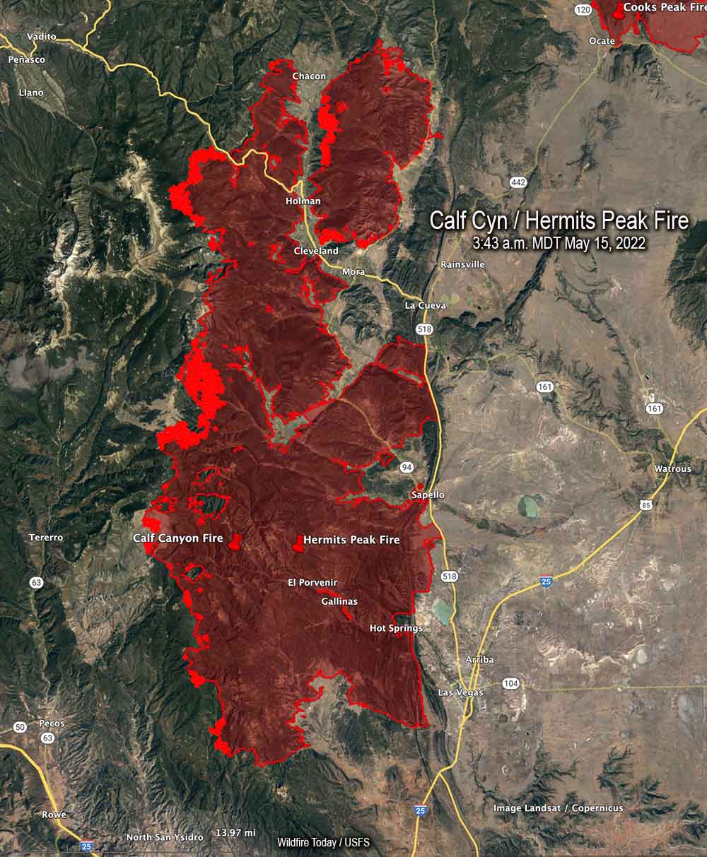
Map of the Calf Canyon / Hermits Peak Fire. The bright red areas represent heat detected by a satellite at 3:43 a.m. May 15, 2022.
The spread of the Calf Canyon / Hermits Peak Fire in Northern New Mexico has slowed in recent days compared to the rapid spread seen early last week during very strong winds and ultra low humidity.
The fire was mapped Saturday evening at 288,942 acres. Most of the activity at that time was on the west flanks, and on the north side near Holman, Chacon, Cleveland, and Mora. Crews are working to keep it away from structures and are putting in additional firelines. The perimeter on the east side between Las Vegas and La Cueva has been secure for several days.
Three Incident Management Teams are assigned. The Southwest Incident Management Team 3 (SWIMT3) has assumed command of the southern half of the fire. The SWIMT 1 took management of the northern half, and the California IMT 2 will work to the north on a bigger-picture strategic plan for control, identifying additional locations where containment lines may be constructed.
The weather forecast for Sunday is west to southwest winds 15 to 20 mph, with gusts to 25 on the north and central zones. Temperatures will range from the upper 60’s to mid-80’s depending on the elevation, with a minimum relative humidity 7 to 11 percent. Even though the wind speeds are not extreme the fire will remain active, with critically dry fuels and near-record high temperatures.
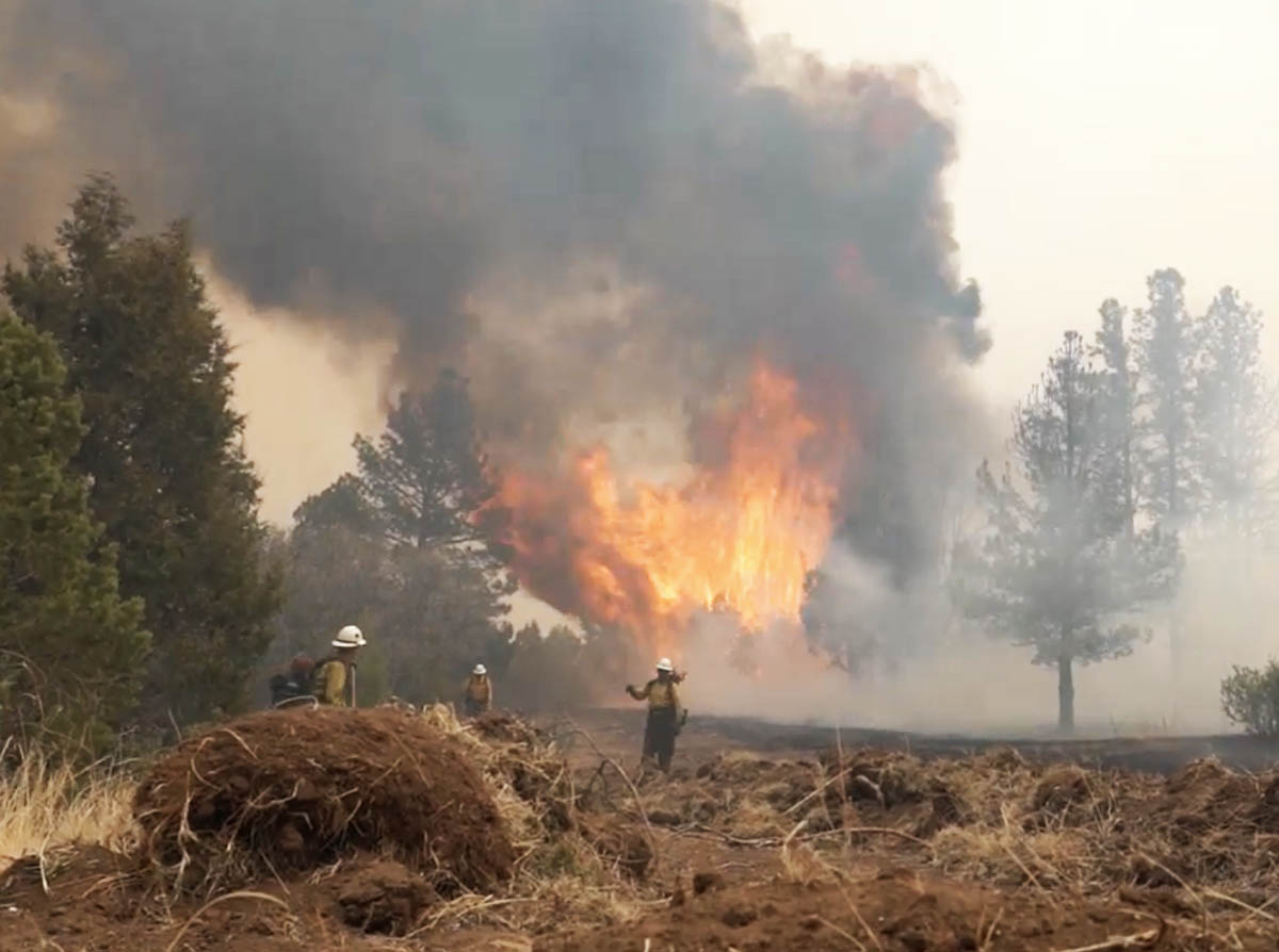
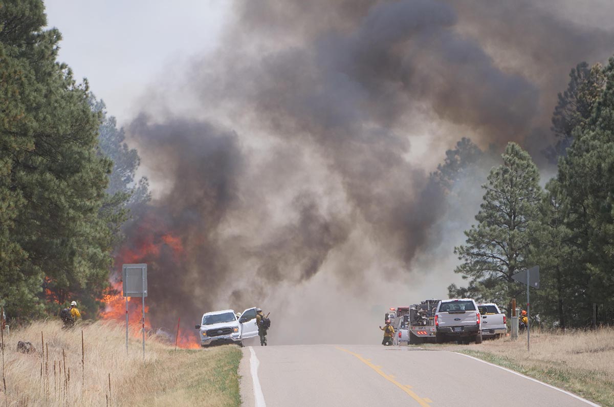
Firefighters on the Calf Canyon – Hermits Peak Fire, near Highway 434, posted by Santa Fe National Forest May 12, 2022.
There is very little fire history out in front of the Calf Canyon – Hermits Peak Fire in Northern New Mexico
9:09 p.m. MDT May 13, 2022
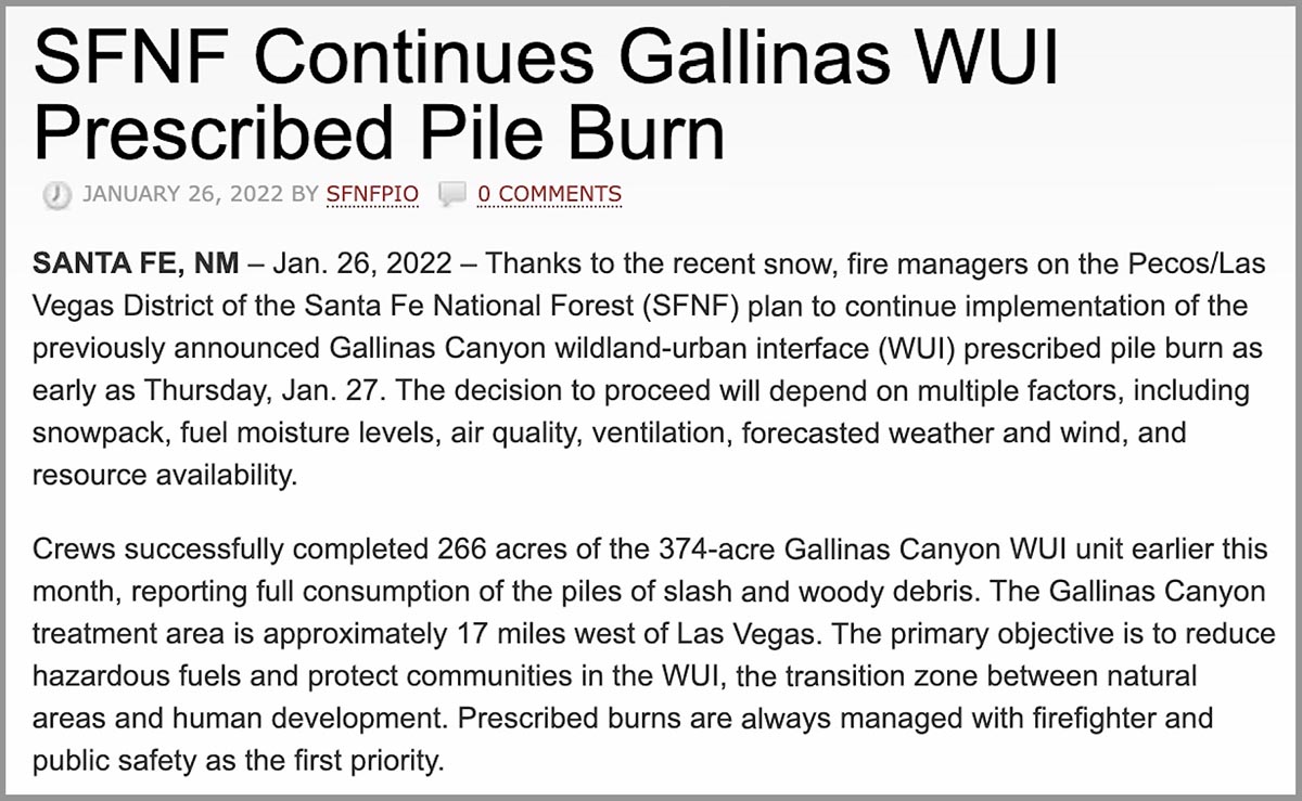
About three months before the Calf Canyon Fire was reported April 19, 2022, employees of the Santa Fe National Forest ignited hundreds of acres of debris piles which were created during fuels treatment projects. The piles were “approximately 17 miles west of Las Vegas,” according to a notice posted at the New Mexico Fire Information website on January 26, 2022. (See below) The name of the project was Gallinas Canyon wildland-urban interface (WUI) prescribed pile burn. In January prior to the notice crews had already completed 266 acres of the 374-acre unit and planned to continue burning more piles “as early as January 27.”
Fires are usually named after a geographical feature near the point of origin. Calf Canyon Road intersects with Forest Road 263 which is in Gallinas Canyon.
On September 27, 2012 a 300-acre hazardous fuels reduction mechanical thinning project was finished just north of Calf Canyon Road, which likely left hundreds of piles to burn later.
This project and Calf Canyon Road are broadly within the general area where the Calf Canyon Fire started. There have also been other fuels treatment projects in that area over the last 10 years.
To see all articles on Wildfire Today about the Calf Canyon and Hermits Peak Fires, including the most recent, click here.
The US Forest Service has already identified an escaped prescribed fire as the cause of the Hermits Peak Fire, but lists the cause of the Calf Canyon Fire as under investigation.
Wildfires, prescribed fires, and pile burns are known to have smoldered for months, sometimes under snow and through an entire winter, before being discovered months later when smoke becomes visible. The burn piles were at approximately 8,000 feet, so the snow reported in the notice may have kept the vegetation cold and wet for a couple of months if the pile burning was completed in February. We are not saying that is what caused the Calf Canyon Fire, but investigators have no doubt evaluated that possibility and ruled it in or out.
Three days after the Calf Canyon Fire was reported strong winds and low humidities combined to caused it to merge with the Hermits Peak Fire and spread 10 miles to the northeast through dry vegetation in a 24-hour period.
What is next for the Calf Canyon / Hermits Peak Fire?
Fire history map, Calf Canyon – Hermits Peak Fire May 12, 2022.
While the Calf Canyon / Hermits Peak Fire has been churning through more than 270,000 acres on its march to the north, at least 90 percent of those acres have burned in areas with no recorded history of previous fires in the national database, going back decades. If that spread to the north and north-northeast continues there is limited significant fire scars in the records out ahead that will slow the fire. (Update May 14, 2022: The NIFC database does not include two fires north of the Calf Canyon / Hermits Peak Fire; the 2020 Luna Fire (10,100 acres) and the 2018 Sardinas Canyon Fire (2,300 acres), according to the link provided in a comment by SE.)
The overall length of the fire is 45 miles as of Thursday night May 12. From the origins they ran north for 32 miles, and south for 13.
There are also no large completed fuel treatment projects in the national database north of the fire that could serve as barriers, except for several near US Highway 64 west of Angel Fire near Valle Escondido 14 miles away. But there are other fuels treatment projects at what is now the southeast corner of the fire in the Barillas Peak area. It has just started to burn into the 2,534-acre “Wildfire Commissary 2015” fire use fire, but it is possible that without too much trouble it could work its way around it, another smaller fire use incident, and a 600-acre prescribed fire conducted in 2004.
At the end of the day on May 12 the north end of the fire was 14 miles from US 64, 19 miles from Taos, 11 miles from the Cooks Peak Fire, and 25 miles from the Philmont Scout Ranch.
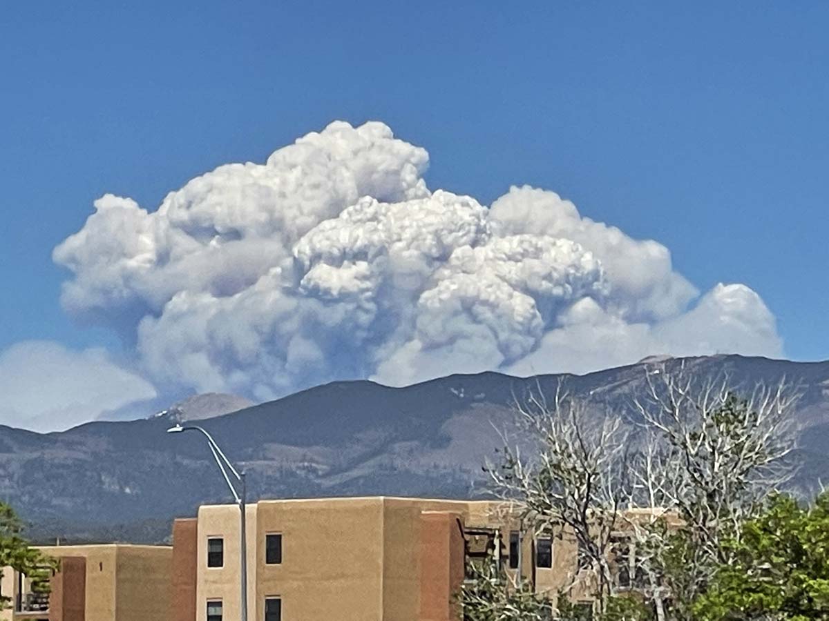
Calf Canyon – Hermits Peak Fire in northern New Mexico, May 10, 2022. Seen from Santa Fe. Photo by Allen Olson.
Most of the growth of the Calf Canyon – Hermits Peak Fire Wednesday was on the north end where it spread for one to three miles further north and northeast. As of Wednesday night at 10:39 it remained west of Highway 434. It increased by about 22,000 acres Wednesday to bring the total up to 259,810 acres.
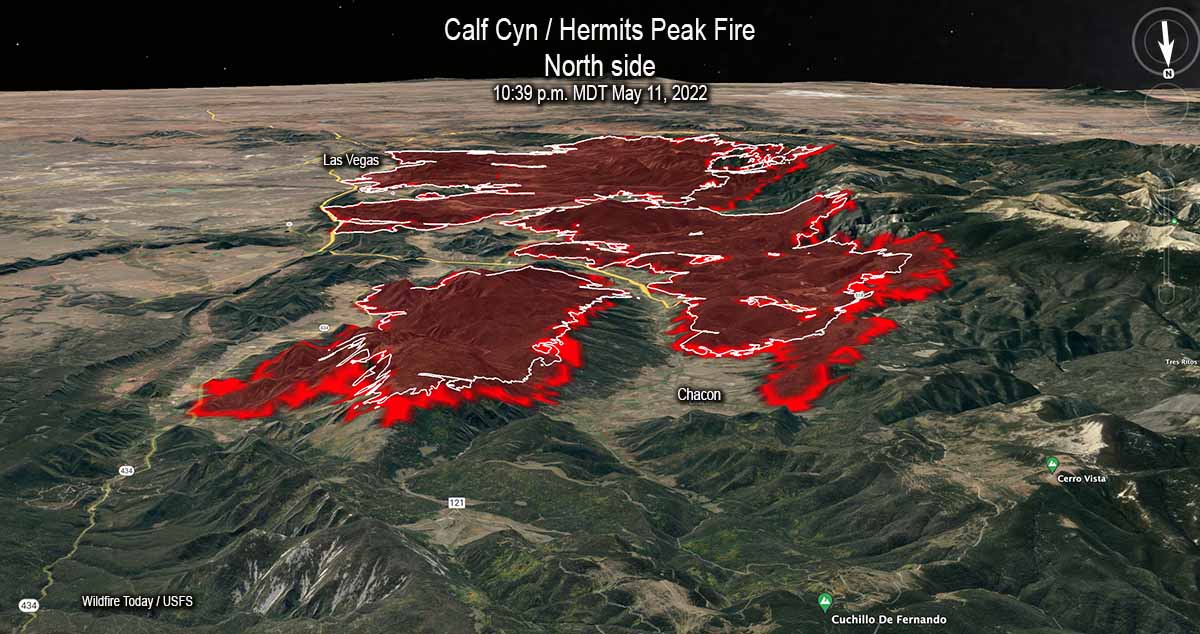
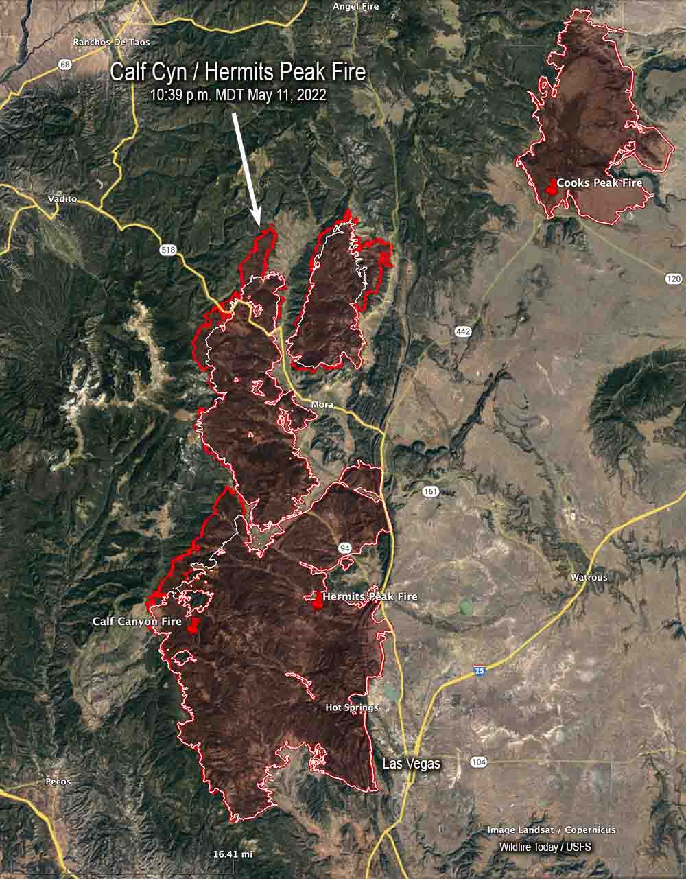
3-D Map of the Calf Canyon / Hermits Peak Fire, looking south. The red line was the perimeter at 10:39 p.m. MDT May 11, 2022. The white line was the perimeter about 24 hours before.Map of the Calf Canyon / Hermits Peak Fire. The red line was the perimeter at 10:39 p.m. MDT May 11, 2022. The white line was the perimeter about 24 hours before.Firefighters hold the Calf Canyon -Hermits Peak Fire at Highway 434, May 10, 2022. Inciweb.
At briefing Thursday morning at 8:30 fire officials said one firefighter working on the Coastal Fire in Orange County, California was injured and transported to a hospital. The evacuation orders are still in place, affecting about 900 homes. The Orange County Sheriff’s office has current information about evacuations.
The estimate of homes destroyed is still at least 20, said Orange County Fire Authority Chief Brian Fennessy. The fire has burned 199 acres.
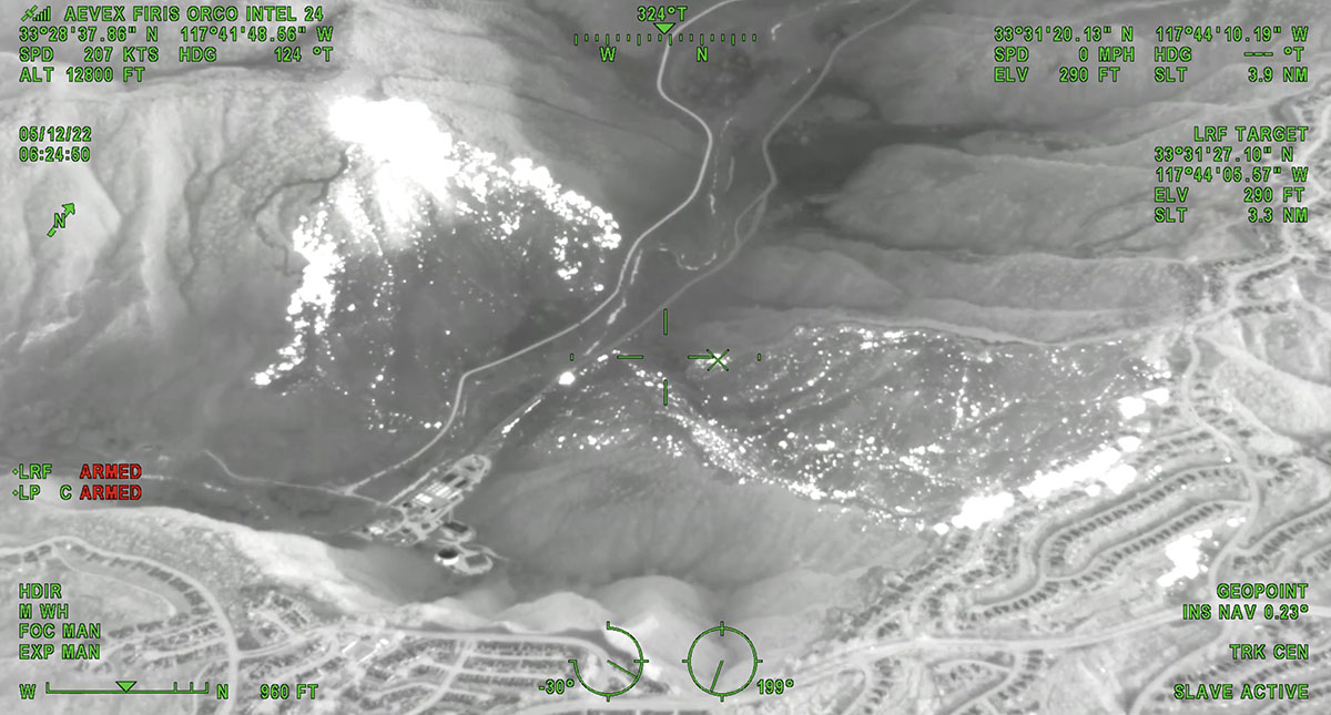
The white areas represent heat on the Coastal Fire detected by FIRIS, 6:24 a.m. May 12, 2022.
10 News reported that Southern California Edison sent a letter to the Public Utilities Commission regarding “circuit activity occurring close in time to the reported time” of the fire, according to the company’s spokesperson David Song.
“We submitted an initial Electric Safety Incident Report to the California Public Utilities Commission,” Mr. Song said. “SCE is required to submit an ESIR to the CPUC on certain types of incidents. … Our information reflects circuit activity occurring close in time to the reported time of the fire. …The submission of this report to the CPUC is intended to put them on notice of an incident so that it can conduct its own investigation.”
Coastal Fire, Orange County, CA, May 11, 2022. ABC7.
Updated at 4:50 a.m. PDT May 12, 2022
Map of the Coastal Fire, 9:57 p.m. May 11, 2022. FIRIS.
Below is a thermal image of the Coastal Fire at 11:13 p.m. May 11. The white areas represent heat.
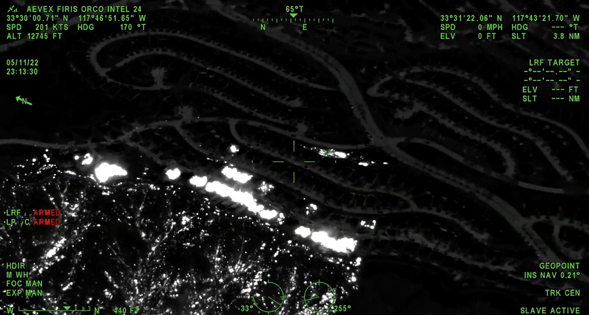
Thermal image of Coastal Fire, 11:13 p.m. May 11, 2022. FIRIS.
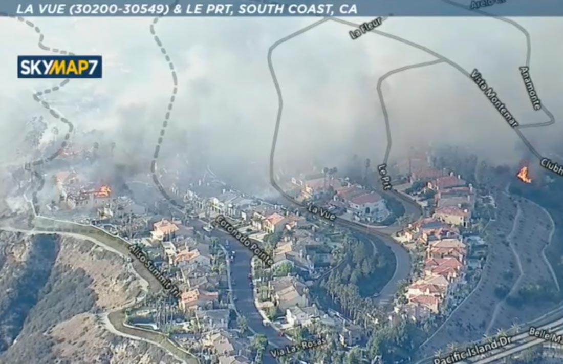
OCFA’s FIRIS Intel 24 on the Costal Incident. Second video of the incident showing the impacted structures along Aliso canyon trail and Coronado point road with the spot fires on top by the club house. Fire is holding at 195 acres. pic.twitter.com/NBMPorYRgD
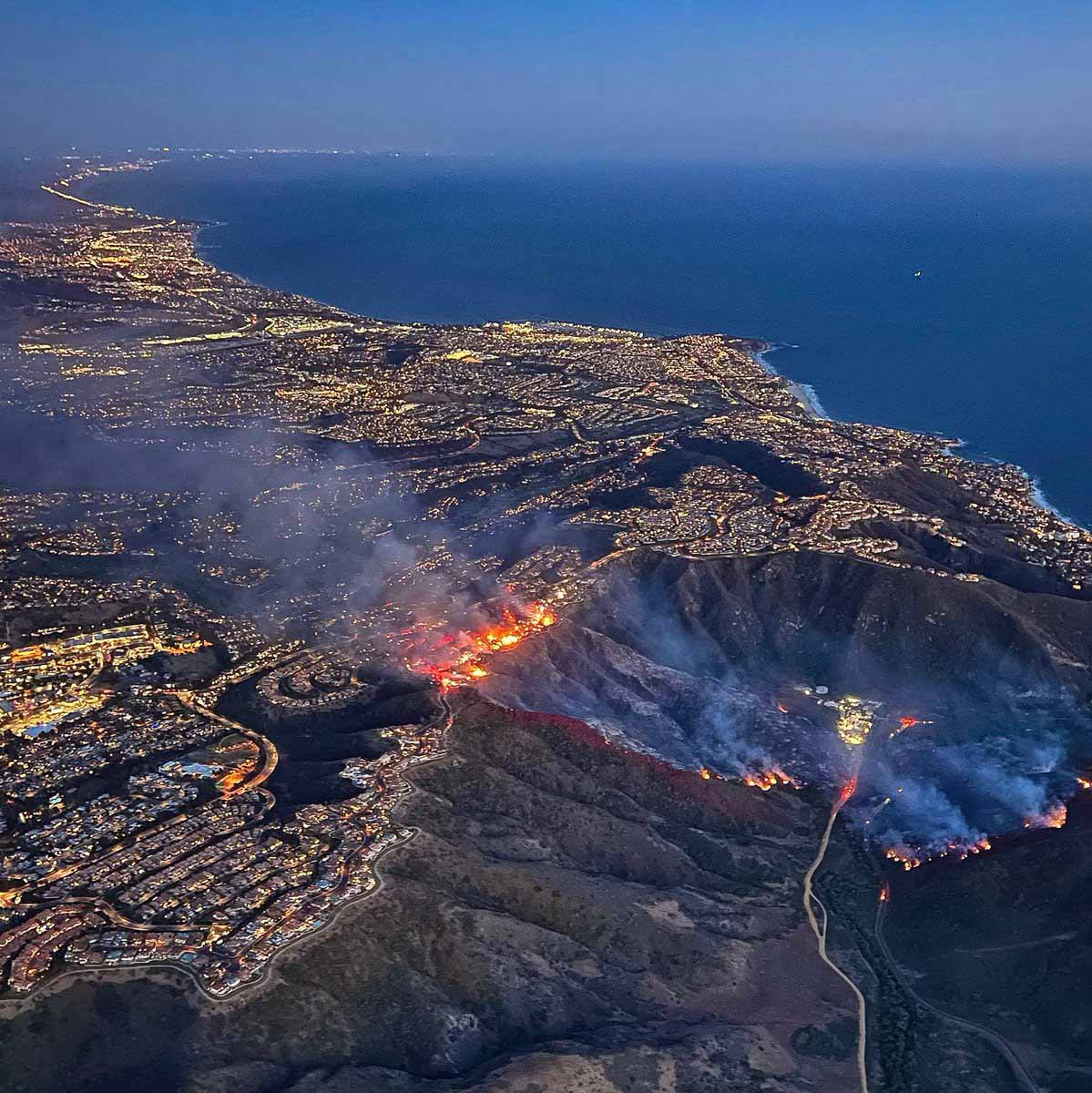
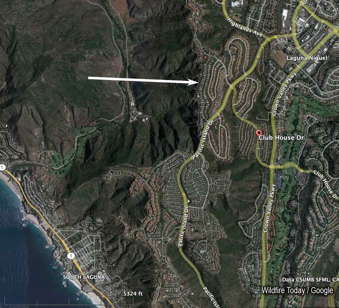
A brush fire in the Laguna Niguel community of Orange County in Southern California spread into homes Wednesday. It was named “Coastal Fire.”
Brian Fennessy, Chief of the Orange County Fire Authority, said at 7:54 p.m. that the fire had burned about 200 acres and he was aware of approximately 20 homes that were destroyed or damaged. The Chief said some of the homes appeared to have been ignited not by direct flame impingement, but from the ember shower, possibly passing through unscreened attic vents.
Image from ABC7 showing the Coastal Fire at 6:10 p.m. May 11, 2022. Looking north.
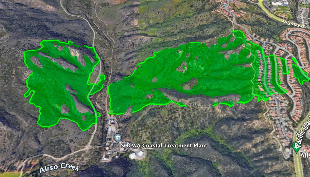
The fire started at about 2:45 p.m. Wednesday approximately a mile east of the coast, west of Aliso Creek, and was pushed by a moderately strong wind out of the west. It burned downhill to the creek, crossed it near a water treatment plant and ran uphill another half mile to rows of large, densely packed homes. By 6:20 p.m. the fire had crossed Pacific Island Drive near Clubhouse Drive.
There was a firebreak below the first structures that were in the path of the fire. It appeared to have prevented flames from the burning brush from directly impacting the homes, but the ember shower and then house to house spread did much of the damage in the community. As homes burned, radiant heat may have ignited the nearby neighboring structures. More embers were generated as each house went up in flames.
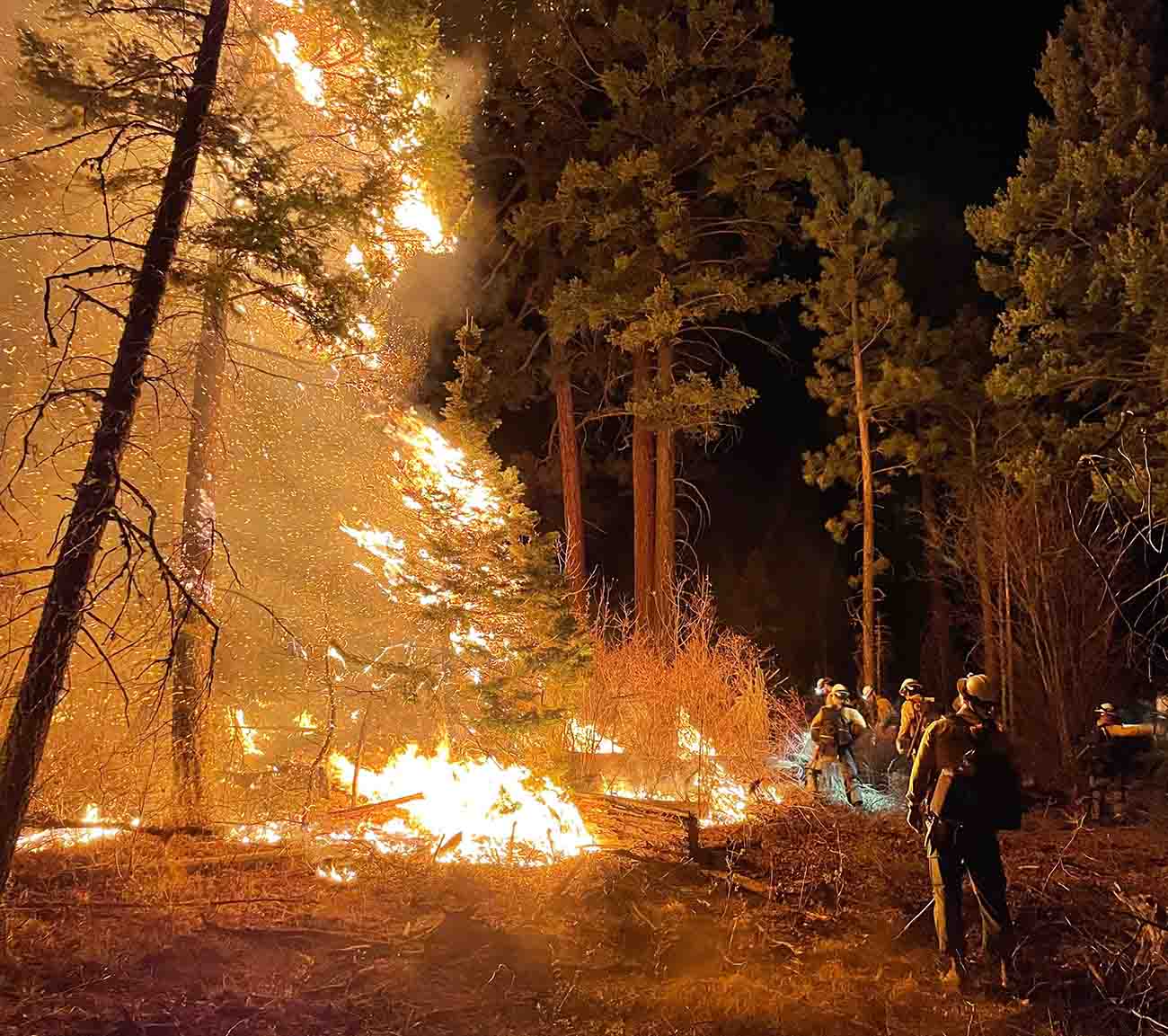
Lone Peak Hotshots conduct a burning operation on the Cerro Pelado Fire in Northern New Mexico, May 10, 2022. Inciweb.
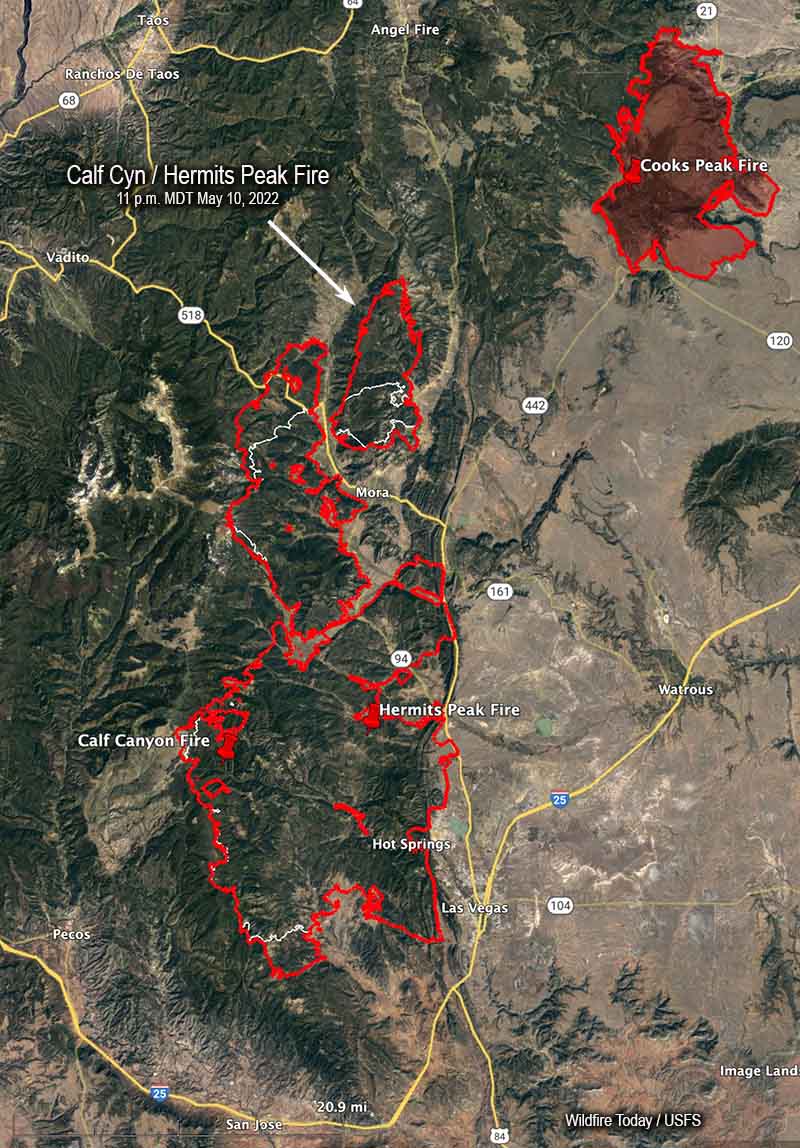
Calf Canyon / Hermits Peak Fire
The Calf Canyon / Hermits Peak Fire made large runs on the north side Tuesday. The area that spotted over Highway 518 a couple of days ago east of Holman spread six miles farther north. Another slopover occurred Tuesday northwest of Holman and ran four miles to the north. When the fire was mapped at 11 p.m. Tuesday the fire had not spread east of the 434 road.
Map of the Calf Canyon / Hermits Peak Fire. The red line was the perimeter at 11 p.m. MDT May 10, 2022. The white line was the perimeter about 24 hours before.
On the south end east of Barillas peak, an area that has been very active recently, it moved another two miles to the south.
Tuesday afternoon I briefly checked an aircraft tracking website and quite a few aircraft working the fire, thanks to a decrease in wind speeds and turbulence. At that time there were two large air tankers (MD-87s), one very large air tanker (DC-10), four scooping air tankers, at least two helicopters, as well as a lead plane and an air attack.
The blaze has now burned 236,939 acres, an increase of about 33,000 acres in 24 hours, and is now 13 miles southwest of the Cooks Peak Fire.
Cerro Pelado Fire
The map produced by an aircraft Tuesday night found incremental differences in the fire perimeter, but no large additional runs. Most of the changes were due to firefighters conducting tactical burning operations to tie in the fire’s edge to roads or other firelines.
The fire has burned 42,491 acres.
8:08 a.m. MDT May 10, 2022
Map of the Calf Canyon Hermits Peak Fire. The red line was the perimeter at 10:24 p.m. MDT May 9, 2022. The white line was the perimeter about 24 hours before. The orange areas represent intense heat when the fire was mapped.
The Calf Canyon / Hermits Peak Fire near Los Vegas, NM grew substantially in two areas Monday and had burned a total of 203,920 acres by evening. On the north side, the spot fire east of Highway 581 that was 200 acres Sunday night spread east for more than 5 miles and burned about 8,000 acres by Monday night. When the fire was mapped at 10:24 p.m. Monday firefighters were holding it at the 434 road.
Calf Canyon – Hermits Peak Fire, Division Bravo at 2 a.m. May 10, 2022. Cory Carlson.
On the southwest side 9 miles west of Las Vegas near the A18A road the blaze spread for another mile and a half to the south. Operations Section Chief Todd Abel said Monday evening that the fire in that area was still within contingency firelines that have been constructed further south. Hand crews and engines are in the area improving lines and protecting structures.
To see all articles on Wildfire Today about the Calf Canyon / Hermits Peak Fire, including the most recent, click here.
On Monday there were scattered areas on the west side of the fire that were very active late in the afternoon.
The very strong wind prevented air tankers from working Monday, but Mr. Abel was gratified that a small Air Attack plane was able to find an altitude without too much turbulence and was able to reconnoiter and provide information to personnel on the ground. At one point we saw on an aircraft tracking site that the aircraft was orbiting at 20,000 feet, much higher than their usual operating altitude.
The Cerro Pelado Fire 7 miles southwest of Los Alamos was active Monday on the northeast and southeast sides. It was mapped Monday night at 42,491 acres, an increase of about 1,500 acres, and still had not crossed Highway 4.
Map of the Cerro Pelado Fire. The red line was the perimeter at 10:24 p.m. MDT May 9, 2022. The white line was the perimeter about 24 hours before. The orange areas represent intense heat when the fire was mapped.
Nearly all of New Mexico is under a Red Flag Warning Tuesday due to strong winds and low humidity.