Calf Canyon and Hermits Peak fires burn together, spread northeast for 10 miles

 Updated 8:53 a.m. MDT April 24, 2022

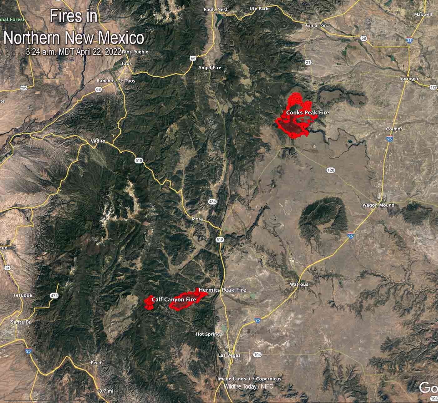
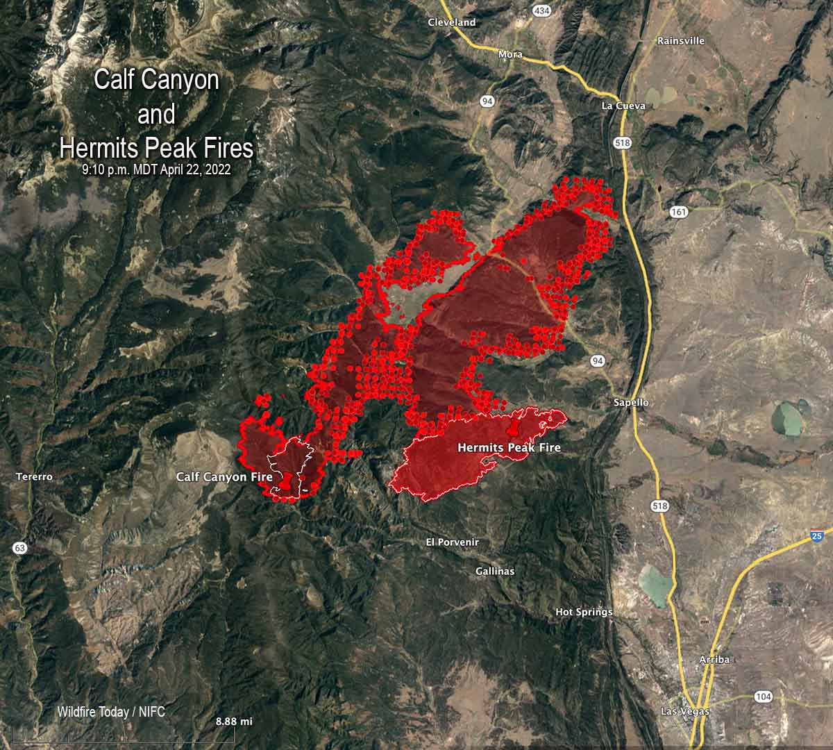
Calf Canyon/Hermits Peak Fire

Map Calf Canyon Fire
Map of the Calf Canyon Fire showing the perimeter in red at 10:45 p.m. MDT April 23, 2022. The white line was the perimeter about 24 hours before. The red dots represent heat detected by a satellite at 2:45 a.m. MDT April 24.

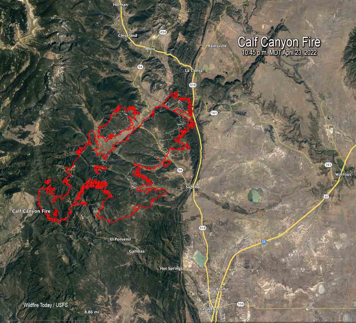
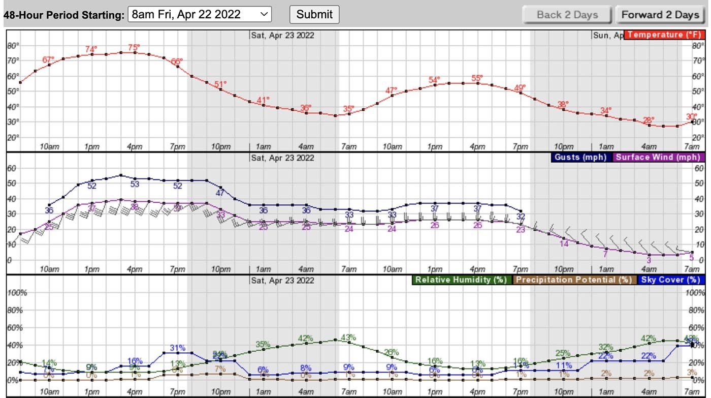
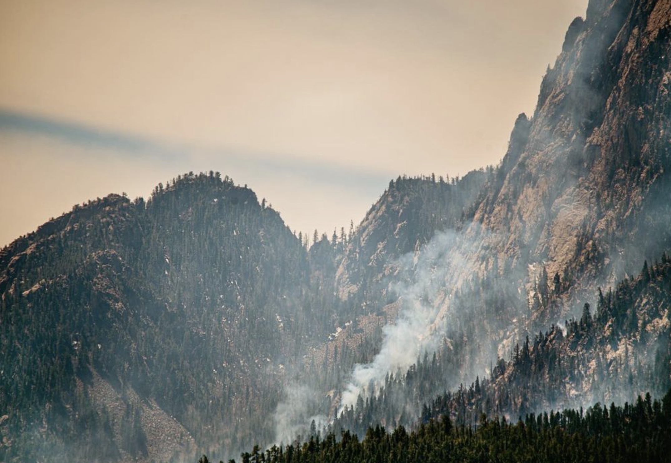
As the wind speeds decreased from the gale force conditions seen Friday, firefighters on the Calf Canyon and Hermits Peak fires that burned together were able to re-engage Saturday. The blazes are about 10 miles north of Las Vegas, New Mexico.

Crews are working on structure protection out ahead of the fire, removing fuel near homes in order to reduce their vulnerability. Dozers are putting in fire line where the terrain permits and the seven hand crews are working in steeper, less rocky areas.

Click to see all articles on Wildfire Today, including the most recent, about the Calf Canyon, Hermits Peak, and Cooks Peak fires.

Even though the fires have merged they are still being treated separately in reports. The combined size determined by a mapping flight at 10:45 p.m. Saturday was 54,004 acres.

“We don’t have enough resources to do everything we want to do at one time so we have to prioritize the resources we have at the right location,” said Incident Commander Carl Schwope in a briefing Saturday evening.

Hermits Peak Fire April 18, 2022
Hermits Peak Fire April 18, 2022 before it merged with the Calf Canyon Fire. By @jennalunaphoto

Reports filed Friday night showed that only seven hand crews were assigned and only one of those was a higher qualified Type 1 crew. A total of 526 personnel were on the fire.

The Incident Management Team that is handling both incidents has ordered “hundreds” of resources, but those orders can only be filled if the personnel and equipment are available.

As of Saturday evening the fire had not crossed the 518 road near the junction of road 161, but it was close and the fire was active in that area.

The Hermits Peak Fire was caused by a prescribed fire that escaped on the Santa Fe National Forest at 4:30 p.m. April 6, 2022. No cause has been released for the Calf Canyon Fire first reported on April 19.
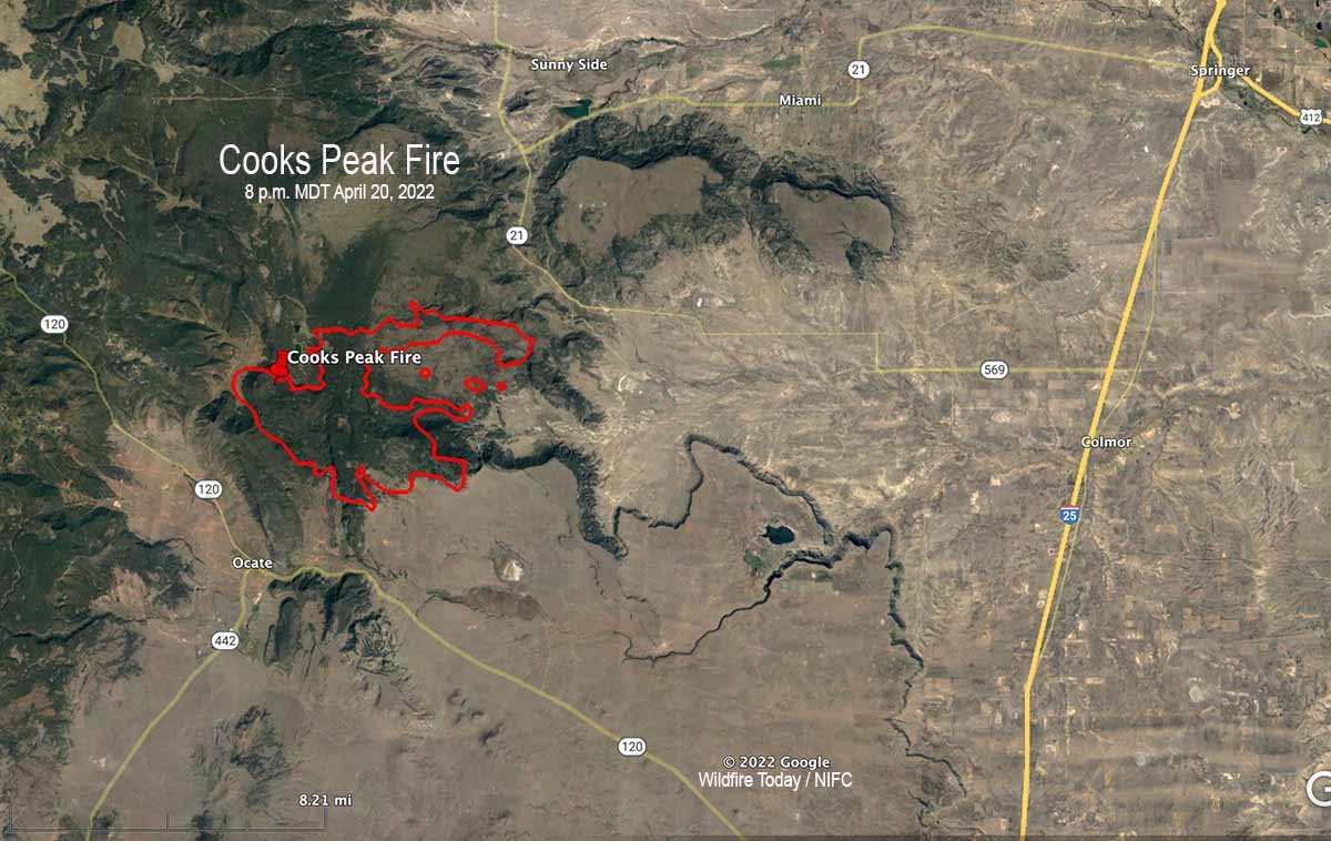
Cooks Peak Fire

The Cooks Peak Fire nine miles south of Cimarron, NM was less active than the Calf Canyon Fire, but its spread was also slowed by a decrease in winds. A mapping flight Saturday night determined it had grown to 51,982 acres.

Map Cooks Peak Fire 130 a.m. MDT April 24, 2022
Map of the Cooks Peak Fire showing the perimeter in red at 1:30 a.m. MDT April 24, 2022. The white line was the perimeter about 24 hours before. The red dots represent heat detected by a satellite at 2:45 a.m. MDT April 24.

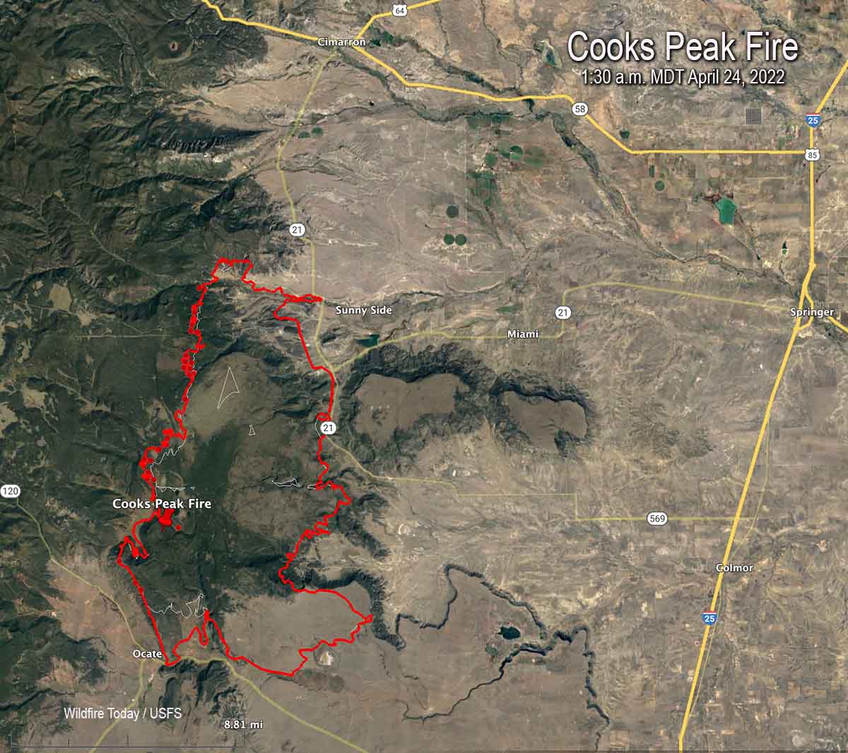
Reports submitted Friday evening showed there were only nine hand crews assigned, with one being a highest qualified Type 1 crew.  A total of 383 personnel were on the fire.


8:26 a.m. MDT April 23, 2022

map Calf Canyon & Hermits Peak Fires
Map of the Calf Canyon & Hermits Peak Fires. The red lines were mapped by an aircraft at 9:10 p.m. MDT April 22, 2022. The white lines were the perimeters about 24 hours before. The red dots represent heat detected by a satellite as late as 3:07 a.m.

Strong winds and low humidities combined to cause two fires to merge and spread 10 miles through dry vegetation in Northern New Mexico Friday. A third fire was also very active. Those fires have now burned a total of approximately 88,000 acres.

Continue reading “Calf Canyon and Hermits Peak fires burn together, spread northeast for 10 miles”

Wildfires in New Mexico have potential to spread significantly Friday during wind event

Extreme fire weather predicted with wind gusts more than 50 mph

Updated 4:14 p.m. MDT April 22, 2022

Satellite photo, New Mexico Fires 336 p.m. MDT April 22, 2022
Satellite photo, showing smoke from the Cooks Peak and Calf Canyon Fires in New Mexico at 3:36 p.m. MDT April 22, 2022. NOAA.

Additional evacuations have been ordered for the Calf Canyon and the nearby Hermits Peak Fires in Northern New Mexico. They were posted at 1 p.m. April 22 by San Miguel and mora Counties in New Mexico. A map is available on Facebook but it is almost undecipherable. Below is a list of the areas affected.

Calf fire evacuations, 1 p.m. MDT April 22, 2022

The satellite photo above shows a large plume of smoke from the Calf Canyon Fire which was blowing northeast over the Cooks Fire when the photo was taken at 3:36 p.m. MDT Friday. It appears that pyrocumulus was forming over the Cooks Peak Fire, indicating extreme fire behavior.

Click to see all articles on Wildfire Today, including the most recent, about the Calf Canyon, Hermits Peak, and Cooks Peak fires.

At 3:04 p.m. MT Friday the Bartley weather station north of the Calf Fire recorded 17 mph winds gusting from the south at 35 mph. The relative humidity was 11 percent.

Smoke maps are posted in another article on Wildfire Today.


9 a.m. MDT April 22, 2022

Map of fires in Northern New Mexico April 22, 2022
Map of fires in Northern New Mexico, 3:24 a.m. MDT April 22, 2022.

The critical and extreme fire weather predicted for areas in New Mexico and Colorado on Friday will affect the three existing wildfires in Northern New Mexico on Friday and Saturday.

The Calf Canyon and Hermits Peak Fires are 24 and 27 miles, respectively, east of Santa Fe, and are northwest of Las Vegas, NM.

The Calf Canyon Fire was very active Thursday, creating a large smoke plume as it spread primarily north and northeast. It was listed at 2,877 acres Thursday night.

The Hermits Peak Fire has been fairly quiet in recent days and is nearing containment. The strong winds will test the fire lines on the 7,573-acre blaze.

The 21,000-acre Cooks Peak Fire 13 miles south of Cimarron was also very active Thursday as it grew to the north and northeast.

The Storm Prediction Center’s forecast for Northeast New Mexico and Eastern Colorado on Friday is for “5-15 percent minimum RH. At the same time, 30-40 mph sustained south-southwesterly surface winds (with widespread gusts of 50-60 mph) will overspread critically dry fuels.” There is a chance for scattered thunderstorms with lightning and little or no rain.

The specific forecast for the Calf Canyon Fire calls for southwest winds of 46 mph gusting up to 64 mph with relative humidity in the teens and 20s. It will also be very windy on Saturday. Conditions on the Cooks Peak Fire will be similar, but with the humidity dropping into the single digits.

The southwest winds on Friday will shift to come out of the west-southwest Friday night, then from the west on Saturday. The speeds will decrease Friday night and Saturday, but will still be sustained in the mid-20s with gusts in the 30s.

These dangerous conditions will be conducive to significant spreading of the Cooks Peak and Calf Canyon Fires to the northeast and east.

Forecast weather Cooks Peak Fire
Forecast for the area near the Cooks Peak Fire. NWS.

Cooks Peak Fire grows to 21,000 acres

16 miles south of Cimarron, New Mexico

3-D Map of the Cooks Peak Fire, 8 p.m. MDT April 20, 2022
3-D Map of the Cooks Peak Fire, 8 p.m. MDT April 20, 2022.

The Cooks Peak Fire in Northeast New Mexico 16 miles south of Cimarron has been very active Thursday afternoon, with reports of pyrocumulus clouds topping the large smoke plume blowing off to the east-northeast.

Click to see all articles on Wildfire Today, including the most recent, about the Calf Canyon, Hermits Peak, and Cooks Peak fires.

The blaze was reported at 4:15 p.m on April 17, 2022. Several ranches are under evacuation orders. The Type 3 Incident Management Team said on Thursday that the fire has burned 21,200 acres.

Cooks Peak Fire. Satellite photo at 3:46 p.m. MDT April 21, 2022.

Resources assigned include 6 hand crews, 11 fire engines, and no helicopters for a total of 198 personnel.

There are no reports of structures burning.

Based on reports of the fire activity on Thursday and the satellite photo of the large smoke plume, the perimeter is most likely significantly different from the one below, mapped Wednesday evening. It likely spread further to the east-northeast.

Map of the Cooks Peak Fire, 8 p.m. MDT April 20, 2022
Map of the Cooks Peak Fire, 8 p.m. MDT April 20, 2022.

Almost all of New Mexico is under a Red Flag Warning Thursday, with a prediction for 20 to 25 mph winds gusting out of the southwest to 60 mph, with 5 to 10 percent relative humidity. The forecast for Friday calls for stronger winds, from the southwest at 40 mph gusting to 57 mph. It will also be very windy on Saturday.

Tunnel Fire in Northern Arizona grows to 20,000+ acres

Strong winds have spread the fire for 12 miles to the northeast

Updated 10:46 a.m. MDT April 21, 2022

From the staff at Sunset Crater Volcano National Monument, which was overrun by the Tunnel Fire.

“April 20

“All Sunset Crater Volcano and Wupatki staff are accounted for and safe. We were also able to successfully evacuate all culturally important items from the visitor center. For those who worried, the Kabotie painting, corn rock, Qa’na Katsina doll, and other items are safe.

“As of 4:45 this morning, the visitor center remains unharmed, as well. However, active fires continue to burn nearby. Sadly, Sunset Crater Volcano National Monument has burned in its entirety. The park is closed, and we do not have any estimated timeline for reopening.”

Sunset Crater Volcano National Monument
File photo of Sunset Crater Volcano National Monument, May 20, 2017.

In the map below, the Monument is inside the yellow border.


7:57 a.m. MDT April 21, 2022

3-D Map Tunnel Fire at 12:30 a.m. MDT April 21, 2022
Map of the Tunnel Fire. Looking southwest at 12:30 a.m. MDT April 21, 2022.

The Tunnel Fire five miles north of the Flagstaff suburbs grew by about 3,000 acres Wednesday to bring the size up to more than 20,500 acres.

To see all articles on Wildfire Today about the Tunnel Fire, including the most recent, click here.

The fire started during the afternoon of April 17 west of Highway 89. Pushed by strong winds it spread rapidly to the northeast, crossed the highway, burned through Sunset Crater Volcano National Monument, crossed major electrical transmission lines, and early Thursday morning was about 10 miles east of Highway 89 approximately two miles from burning out of the Coconino National Forest.

Map Tunnel Fire 12:30 a.m. MDT April 21, 2022
Map of the Tunnel Fire at 12:30 a.m. MDT April 21, 2022. The brown shaded areas represent intense heat at the time the fire was mapped.

On Wednesday crews worked to keep the fire out of the Timberline Estates and Wupatki Trail subdivisions. They encountered natural gas leaking from foundations of burned structures, which slowed suppression activities. On Tuesday fire officials said 24 structures had burned. The number was not broken down by residences or outbuildings.

Strong winds on Wednesday again limited the ability of aircraft to safely and effectively support firefighters on the ground. Conditions are expected to become windier Thursday and Friday. A Red Flag Warning is in effect Thursday until 8 p.m. MST due to predicted gusts of 40 to 50 mph and 10 to 15 percent relative humidity.

Tunnel Fire, April 19, 2022
Tunnel Fire, April 19, 2022, as seen from O’Leary Lookout in Northern Arizona. USFS photo.

A National Type 1 Incident Management Team was ordered Tuesday. The 76 personnel with the team will begin arriving Thursday, with plans to assume command from the Type 3 IMT Friday morning.

Firefighting resources on scene include three dozers, 24 fire engines, and one Type 3 helicopter, for a total of 260 personnel.

U.S. Highway 89 is still closed from milepost 425 (Campbell Road) to milepost 445 and will likely remain closed for the next several days due to firefighting operations.

Information about evacuations, structures that have burned, and when people might be able to return is handled by Coconino County, which is posting updates online.

Satellite photo fires in Arizona, 6:31 p.m. MDT April 20, 2022
Satellite photo showing smoke from fires in Arizona, 6:31 p.m. MDT April 20, 2022.

Forest Service releases Eicks Fire smokejumper fatality report

Tim Hart passed away June 2, 2021

Eicks Fire, resources dispatched
Eicks Fire, resources dispatched. (from the report)

On May 24, 2021, Smokejumper Tim Hart was severely injured while parachuting in to the Eicks Fire in southern New Mexico and passed away on June 2. Today the US Forest Service released a “Learning Review — Technical Report”. Until now the only information officially released about the accident was that he suffered a hard landing in rocky terrain at the fire.

The 55-page report gets heavily, necessarily, into smokejumper technical information and jargon, but does a pretty good job of explaining so it is fairly easy for non-jumpers to understand.

The fire was in a very remote area on private land in the boot heel of New Mexico seven miles north of the US-Mexico border. Ground resources on initial attack included a couple of engines that were hours away and eight smokejumpers dispatched from Silver City, NM.

This is how the report describes the moment the hard landing occurred:

With Jumpers 4 and 5 on the ground, attention focused on Tim. He was still 200 yards southeast of the jumpspot and three-quarters of the way up the boulder-strewn ridge south of the bowl. He was flying up drainage 200 to 300 feet above the drainage bottom, hands positioned at quarter-brakes to full run. Those who could see the flight remember him flying in this direction for one to three seconds before the canopy turned 90 degrees to the left towards the center of the drainage. The cause of the 90-degree turn is unknown, as no one witnessed a left toggle input initiating the turn. At approximately 200 feet [above ground level] the canopy increased in speed and “came out of the air super-fast, like he got caught in a burble.” The Jumper in Charge (JIC) turned to Jumper 2, who had a streamer held high as a wind indicator for the other Jumpers, and exclaimed, “Are you seeing this right now?” Tim’s hands were on the toggles, and the JIC thought, “You need to turn, anywhere but where you are on final,” and waited for a turn at the last second. The JIC said he had “never seen an angle of attack on a Ram-Air like that before.” The JIC and Jumper 2, without another word, began running towards where Tim was going to land, calling to him without hearing a response. Tim had landed on the side of the drainage, uphill into “rocks the size of garbage pails.”

Thankfully, four of the seven jumpers assisting Tim were EMTs. He had a head/neck injury, was unconscious, had a weak pulse, and other injuries. The jumpers on the ground called for the trauma bag to be dropped from the jump plane. The EMTs stabilized his head and neck, administered oxygen, and splinted what was described as “secondary injuries.” Within 15 minutes of the patient being ready for transport and the landing zone being established, a medivac helicopter arrived on scene. He was extracted from the site one hour and 15 minutes after the injury.

Tim passed away nine days later.

The report describes how increasingly turbulent winds on the lee side of a ridge resulted in very complex wind patterns at the jump spot. Two subject matter experts, W. Kitto and M. Gerdes, wrote in Appendix D:

The accident pilot flew into an area where the conditions were not only challenging, but most likely intolerable (turbulence in excess of the parachute’s limitations), i.e. any pilot of any skill level on any similar equipment would likely have been unable to prevent a hard landing, due to rotor. Mechanical rotor turbulence alone or combined with thermal turbulence can easily create “unflyable” conditions.

From the report:

“Tim began as a smokejumper rookie in 2016 and was trained on the Forest Service Ram-Air parachute system. He was beginning his sixth season as a smokejumper, with a record of 95 jumps (73 proficiency and 21 fire). In 2021, he was on his third stint as a Silver City, NM, Smokejumper detailer. Tim had two previous fire jumps out of Silver City, one each in 2018 and 2019 on the Gila National Forest. Over that same time period, he had three proficiency jumps out of Silver City, all at the Fort Bayard practice jumpspot, the most recent on May 22, 2021.”

Tim Hart
Tim Hart. USFS photo.

Thanks and a tip of the hat go out to Ben.

Tunnel Fire spreads across Hwy. 89 north of Flagstaff, AZ

A Type 1 Incident Management Team has been ordered

Updated 4:09 p.m. MDT April 20, 2022

The National Weather Service has issued a Red Flag Warning for northern Arizona from 11 a.m. until 8 p.m. MST, for 15 to 25 mph winds gusting to 35 and 11 percent relative humidity.

To see all articles about the Tunnel Fire on Wildfire Today, including the most recent, click here.


Updated 11:20 a.m. MDT April 20, 2022

map Tunnel Fire 4 a.m. April 20, 2022
Map of the Tunnel Fire 4 a.m. April 20, 2022. The green line designates the “go”, evacuate now area. The yellow line is the “set”, be prepared to evacuate area.

The Tunnel Fire north of Flagstaff was mapped at approximately 16,625 acres at 4 a.m. Wednesday. The map above shows the go-now evacuation areas in green which affect about 750 homes.

Tuesday afternoon and night the fire burned through the Sunset Crater Volcano National Monument and kept going toward the northeast for another three to four miles. At 4 a.m. Wednesday it was about three miles from burning out of the Coconino National Forest.

The Arizona Department of Transportation reports that US Highway 89 is closed in both directions. There has been no update on the number of structures destroyed since Tuesday when it was announced that 24 had burned. The number was not broken down by residences or outbuildings.

Tunnel Fire, April 19, 2022
Tunnel Fire, April 19, 2022.

The winds on Wednesday are predicted to be less extreme than on Tuesday. The National Weather Service forecast calls for 20 mph winds gusting out of the southwest at 25 mph, with 17 percent relative humidity under clear skies. The wind speeds will increase on Thursday, 23 mph gusting to 35, still out of the southwest and 18 percent relative humidity. Then on Friday the speeds increase to 29 mph gusting to 45 mph from the southwest, but with higher humidity — 30 percent —  and a chance for 0.01 inch of rain Friday afternoon.

The Incident Management Team was apparently too busy Tuesday evening to submit the routine Incident Status Summary report, therefore limiting the amount of specific information available. A Type 1 IMT, Northwest Team 3 with Incident Commander Johnson, has been ordered.


10:13 p.m. MDT April 19, 2022

Map Tunnel Fire, 6:21 p.m. MDT April 19, 2022
Map of the Tunnel Fire, 6:21 p.m. MDT April 19, 2022.

The Tunnel Fire four miles north of the Flagstaff suburbs was very active Tuesday afternoon, spreading across Highway 89 into Sunset Crater Volcano National Monument. Authorities with the Coconino National Forest estimated that by late in the afternoon on Tuesday it had grown to about 6,000 acres.

It was reported at 4:22 p.m. on Sunday April 17 (however some sources say it was on April 18). The cause is under investigation. Coconino County has the official evacuation information.

Tunnel Fire, April 19,2022
Tunnel Fire looking north from Lunar Dr. just south of Silver Saddle, April 19, 2022. Photo by Deborah Lee Soltesz.

Strong southwest winds that pushed the fire to the northeast are predicted to continue through Tuesday night at 30 mph gusting at 40 to 54 mph while the relative humidity remains below 30 percent. On Wednesday the winds will still be out of the southwest, but will decrease to 10 to 20 mph with gusts up to 30 mph while the relative humidity drops to 17 percent. With that forecast the fire will likely remain very active Tuesday night moving northeast.

The Forest Service said Tuesday night that 24 structures had burned.

Firefighting resources assigned include five handcrews, 15 engines, and three dozers. Air tankers were ordered Tuesday afternoon but had to be grounded due to very strong winds.

A Type 1 Incident Management Team has been ordered.