Firefighters battling wildfire east of Hutchinson, Kansas

About 32 miles northwest of Wichita

Updated at 1:37 p.m. CT Feb. 9, 2022

The Hutchinson Fire Department said in a news release Wednesday morning that the fire east of the city, now named the Albright Fire, was about 90 percent contained.

Pushed by strong winds, the fire which started south of Buhler ran south for about two miles from 30th Avenue to 4th Avenue. Firefighters worked Tuesday night and by morning all roads had reopened but burnout operations may cause temporary closures of some streets.

Fire Marshal Michael Cain has been investigating the fire to determine the cause, which is still believed to be embers from some of the 75 brush piles that were ignited on private land last Thursday when snow was on the ground. Warmer weather melted the snow rapidly and at least one of the piles spread Tuesday during the strong winds as the humidity dropped to 13 percent.

Damages to property and the total number of acres burned was still being determined Wednesday morning.


Updated at 12:37 a.m. CST Feb. 9, 2022

The winds that had been gusting at more than 30 mph slowed after 6 p.m. on Tuesday making it much easier for firefighters to begin to get a handle on a large wildfire a few miles east of Hutchinson, Kansas. Combined with relative humidity that dipped as low as 13 percent the strong winds resulted in the fire spreading south for nearly two miles from where it started just south of 30th Avenue near Buhler Road.

From the Hutchnews:

“By the time we got there, it was already running north to south,” Fire Chief Steve Beer said. “Numerous departments were called in to help with structure protection. We started an early evacuation of two or three dozen homes. We got everyone safely evacuated who wanted to leave.”

The evacuation was primarily in homes along Fourth Avenue, Beer said. It wasn’t a mandatory evacuation, so not everyone left.

“The fire didn’t move that fast,” Beer said. “But when it got in the cedars it would throw flames 50 feet into the air. It’s pretty impressive to watch. We’re thankful, it was not as bad as it could have been. The key to this area is to do back-burns. Once we did get ahead of it with enough resources, we got a handle on it.”

Fire officials said the likely cause was embers from woodpiles that were burned over the weekend.

As the weather conditions moderated, by 7 p.m. Tuesday some firefighting resources were being released and residents were expected to be back in their homes later in the evening.

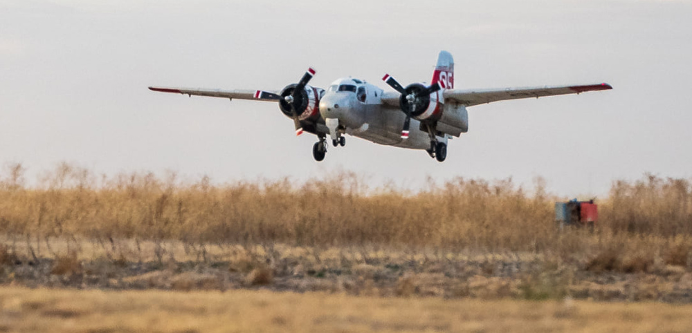
Chief Beer said the S-2 air tanker aided firefighters by attacking the blaze in areas that were difficult for them to access due to sandy soils and cedar trees.


Originally published at 5:44 p.m. CST Feb. 8, 2022

Hutchinson Fire map
The map shows red squares that represent the approximate locations of heat at a fire detected east of Hutchinson, Kansas by the GOES-16 satellite at 2:40 p.m. CT Feb. 8, 2022.

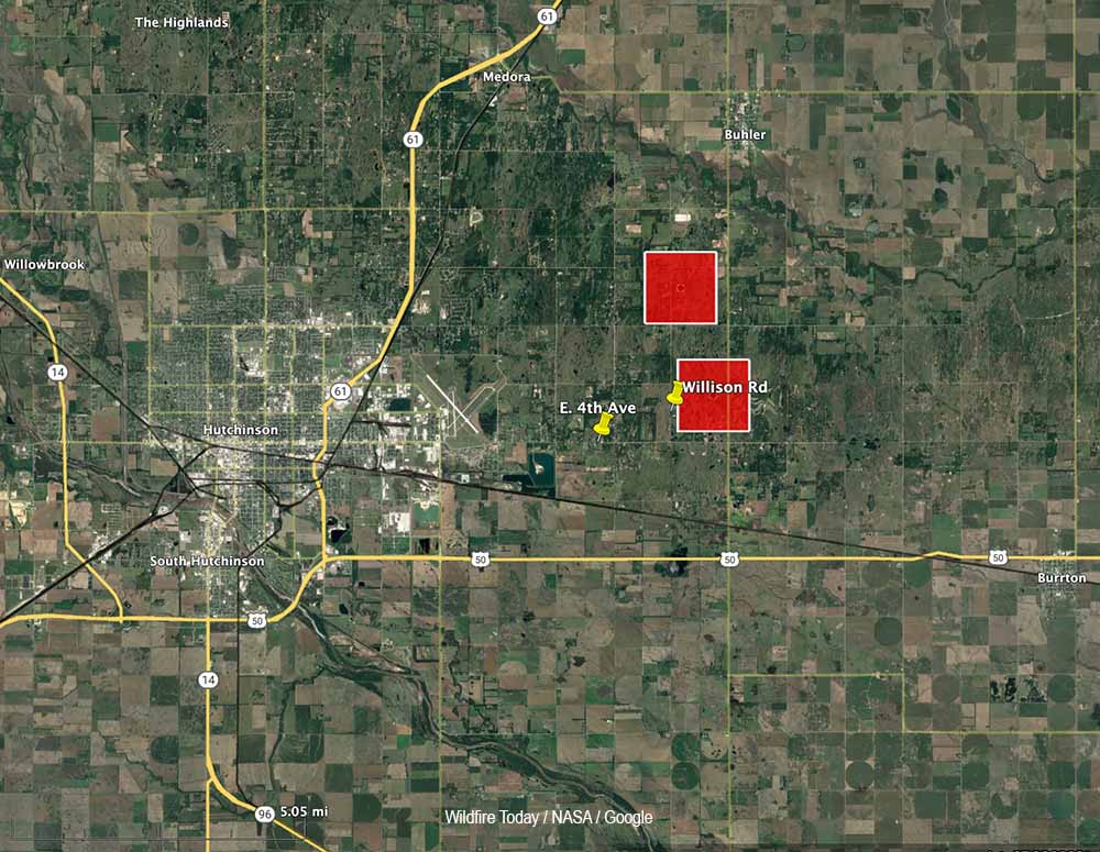
Firefighters are working to contain a large wildfire about three miles east of Hutchinson, Kansas. Strong winds out of the north gusting to 36 mph are pushing the blaze to the south.

Crews are working to save structures near the intersection of East 4th Avenue and Williston Road.

The area is under a Red Flag Warning for high fire danger due to the powerful winds. The relative humidity was measured at 13 percent in Hutchinson at 4:52 p.m. The National Weather Service expects the wind speeds to decrease after sundown.

The fire is approximately three miles east of Hutchinson, about 2 miles south of Buhler, and 32 air miles northwest of Wichita.

Air tanker 95, a privately owned S-2, was dispatched to the fire. It is operated by Ag Air Service out of Nikerson, Kansas.

Air Tanker 95, an S-2
Air Tanker 95, an S-2. Kansas Forest Service photo.

Thanks and a tip of the hat go out to Matt.

Coal underground may have been burning for 150 years near where the Marshall Fire started northwest of Denver

Coal mine at Marshall, Colorado, 1884 until 1936
Coal mine at Marshall, Colorado, 1884 until 1936. 9News

A television station in Denver, 9News, has found that in the general area where investigators are narrowing down the origin and cause of the Marshall Fire northwest of Denver an underground coal seam has been burning since the 1870s.

In December, 2005 after a portion of the burning seam emerged on the surface and started a vegetation fire the Office of Surface Mining advised the City of Boulder, which owns the land, “It would be prudent for the City of Boulder to remove any vegetation from surface cracks, as well as begin a long term maintenance and monitoring program for the area.” In 2005 the spread of the fire was stopped quickly.

The City hauled in 275 tons of gravel with the intention of least insulating the fire from the surface. But these underground fires have a habit of creeping their way back up and too often ignite fires. They are next to impossible to extinguish.

9News reported that the M. P. Fox mine in the area operated from 1884 until 1936.

Pushed by winds gusting at 60 to 100 mph, the Marshall Fire spread rapidly as it destroyed more than 1,000 homes. Most were in the city of Louisville and the town of Superior.

The 9News video below has more details.

On a different topic, but related to the Marshall Fire, we learn in the next video that 17 of the houses that were in the burned area but survived have been sold.

Thanks and a tip of the hat go out to Gerald.

Officials are investigating smoldering coal mine as cause of Marshall Fire

The rapidly spreading blaze destroyed more than 1,000 homes northwest of Denver December 30

Marshall fire possible origin area

Investigators are looking at an old coal mine as the possible cause of the Marshall Fire northwest of Denver, Colorado. Decades ago miners were extracting coal from an area near the location where the Marshall Fire started December 30, 2021. The remaining coal has been burning for years even though dozens of tons of fill were hauled in with the intention of stopping the burning, or at least insulating the fire from the surface. But these underground fires have a habit of creeping their way back to the surface and too often ignite a vegetation fire.

The old mine near the intersection of Highway 93 and Marshall Drive near the town of Marshall is one of 38 active underground coal fires in Colorado. In 2002 a burning underground coal seam ignited vegetation near Glenwood Springs, Colorado which burned 29 homes and more than 12,000 acres.

Wildfire Today had an article in 2008 about an 8-year-old boy who suffered burns on his foot when he walked into an area of Golden Hills park in Colorado Springs, Colorado that was covered in coal dust. Left over from coal mining operations about 80 years earlier, the dust was on fire, smoldering, and it melted the boy’s plastic shoe and gave him second degree burns. If the boy had not “discovered” the fire, it would have spread into nearby vegetation. The cause of the fire was unknown.

Pushed by winds gusting at 60 to 100 mph, the Marshall Fire spread rapidly last month as it destroyed more than 1,000 homes. Most were in the city of Louisville and the town of Superior.

Wildfire north of Big Sur prompts evacuations

The fire named “Colorado” has burned about 700 acres near Highway 1 near the California coast

Updated at 7:11 p.m. PT Jan. 22, 2022

Colorado Fire
Smoke drifts away from the Colorado Fire as the sun sets. Photographed by the Keig/Yankee Point camera looking south at 5:24 p.m. Jan. 22, 2022.

The Colorado Fire north of Big Sur, California was mapped at 683 acres by the Fire Integrated Real-Time Intelligence System (FIRIS) aircraft at about 5 p.m. Saturday. This is less than half of the earlier 1,500-acre estimate by the California Department of Forestry and Fire Protection. Fires look larger at night and the terrain at the fire scene is very rugged and difficult to map from the ground.

Colorado Fire map
Colorado Fire, 3-D map, approximate location, looking east at 5:24 p.m. PT Jan. 22, 2022.
Colorado Fire vicinity map
Colorado Fire vicinity map 5:24 p.m. Jan. 22, 2022. Showing part of the footprint of the 2016 Soberanes Fire.

A satellite overflight at 1:22 p.m. local time showed that the fire had spread on the south side near Rocky Creek and on the northwest side southeast of Notleys Landing south of Palo Colorado Road. There has been no indication that the fire has crossed Highway 1, reached the coast, or made any large runs on Saturday afternoon. The fire cameras in the area did not pick up any large smoke columns.


1:04 p.m. PT, Jan. 22, 2022

Colorado Fire, 3-D map
Colorado Fire, 3-D map showing the APPROXIMATE perimeter at about 4:20 a.m. PT Jan. 22, 2022. Looking north.

A wind-driven wildfire that broke out Friday afternoon north of Big Sur, California has prompted evacuations. The fire just east of the Pacific Coast Highway has forced residents to leave their homes and officials to close a portion of the iconic highway.

The blaze started near Palo Colorado Canyon Road which led firefighters who usually name a fire after a local landmark, to call it the “Colorado Fire.” (A name which will likely result in confusion.)

Colorado Fire vicinity map
Colorado Fire vicinity map ~420 a.m. PT Jan. 22, 2022.

Monterey County has created a map showing evacuations in effect.

The incident is nine air miles north-northwest of Big Sur and seven air miles south of Carmel Highlands.

At 8:19 a.m. on Saturday the California Department of Forestry and Fire Protection said it had burned about 1,500 acres, but that figure is subject to change. At 12:30 p.m. PT there were several CAL FIRE S-2T air tankers flying near the fire.

The Colorado Fire was pushed Friday evening by very strong winds out of the northeast, measured at 41 mph gusting to 52 mph at 5 p.m. at the Old Coast Tower weather station east of Point Sur. The relative humidity was 21 percent. This caused the fire to spread west and southwest, cresting the ridge east of the Pacific Ocean; then the wind shifted. After 9 p.m. it decreased to 10 mph from the south and southeast. Around dawn on Saturday it shifted again, from the north and northwest at 5 to 8 mph. Overnight the humidity rose to 60 percent but dropped to about 30 percent at 11 a.m.

Colorado Fire map
Colorado Fire map at about 4:20 a.m. PT Jan. 22, 2022.
Colorado Fire, Jan. 22, 2022
Colorado Fire, Jan. 22, 2022. CAL FIRE photo by David Hudson.

Thanks and a tip of the hat go out to Pat.

Firefighter killed, one injured in South Australia

They were working on the Coles Fire northwest of Coonawarra

Map Coles Fire
Map showing the location of heat detected on the Coles Fire at 1605 UTC Jan. 20, 2022 in South Australia.

One firefighter working on the Coles Fire in South Australia has been killed and another hospitalized, the state’s Country Fire Service announced on Friday. The agency said “they were involved in a falling tree incident.”

In a news release the Country Fire Services said, “Family and other personnel have been informed and are being offered support at this time. The seriously injured CFS member has been taken to hospital for further treatment. The safety and wellbeing of our people is our highest priority and our thoughts are with our CFS family at this time.”

From The Guardian:

One firefighter has died and another has been seriously injured after a tree collapsed on a fire truck battling an out-of-control bushfire in South Australia’s south-east.

The incident occurred at the firefront at Coles, near Lucindale, where the blaze was running uncontrolled through bluegum plantations, scrub and grassland, a spokeswoman for the state’s Country Fire Service said.

The Coles Fire, first reported January 19, has burned 3,835 ha (9,476 a) about 28 km (17 miles) west-northwest of Coonawarra in southeast South Australia.

Data from the U.S. National Interagency Fire Center in 2016 showed that in the United States hazardous trees was the fifth leading cause of wildland firefighter fatalities, behind medical, aircraft accidents, vehicle accidents, and entrapments.

Our sincere condolences go out to the family, friends, and co-workers of the two firefighters.

Thanks and a tip of the hat go out to Tom.

Escaped prescribed fire prompts evacuations southeast of Austin, Texas

The County Judge responsible for fire suppression in Bastrop County, said, “None of us can predict the weather more than 15 minutes ahead of time.”

Updated at 9:13 a.m. CT Jan. 20, 2022

Map, Rolling Pines Fire Jan. 19, 2022
Map showing the location of the Rolling Pines Fire, 1:37 a.m. CT Jan. 19, 2022.

Maps of the Rolling Pines Fire near Bastrop 28 miles southeast of Austin, Texas.

Map, Rolling Pines Fire Jan. 19,2022

At least one large air tanker was used on the fire, including the RJ85 seen above.


Originally published at 9:03 p.m. Jan. 19, 2022

Rolling Pines Fire
Rolling Pines Fire, Jan. 18, 2022. Mario V.

A prescribed fire in Bastrop State Park 28 miles southeast of Austin, Texas escaped on Tuesday. County Judge Paul Pape said 250 families were required to evacuate as the fire that was intended to burn 150 acres grew to 783 acres by Wednesday morning. At 6 p.m. Wednesday some of those residents were allowed to return to their homes. The fire was named “Rolling Pines Fire.” There were no reports of injuries or any residences that burned.

At 10:30 a.m. on Tuesday Texas Parks and Wildlife Department initiated the prescribed fire at the State Park. Shortly after noon spot fires occurred outside the area that was intended to be burned, according to Carter Smith, Executive Director of Texas Parks and Wildlife.

Texas is one of a few states that designate a county judge or sheriff, rather than fire professionals, to be *responsible for suppression of wildfires outside of incorporated cities. In Texas, judges take on that role. In a news conference County Judge Paul Pape said he is responsible for emergency response in Bastrop county.

Judge Paul Pape
Basrop County Judge Paul Pape. KXAN.

Judge Pape was asked by a reporter in a news conference Tuesday why on a day when local fire departments were advising residents to not do any outdoor burning due to strong winds, the state park decided to conduct the prescribed fire. He deferred the question to Carter Smith, Executive Director of Texas Parks and Wildlife, who said, “It is my understanding that we were well within the prescription of the weather parameters that were called for in the plan.”

Judge Pape said, “Based on everything they knew this morning, it was an appropriate day to burn. None of us can predict the weather more than 15 minutes ahead of time, and sometimes things happen we just don’t anticipate. I’m not going to be critical of the efforts to protect our citizens from wildfire by using prescribed burns. I think it’s a great tool and one that we need to continue to encourage people to use.”

A weather station near Bastrop, BTRT2, at 12:08 p.m. on Tuesday January 18 recorded sustained wind speeds of 16 mph with gusts up to 25 mph out of the south-southwest while the relative humidity was 53 percent. During the next four hours the RH dropped to 40 percent with south winds of 13 mph gusting to 23 mph. The 10-hour time lag fuel moisture during that time dropped from 11 percent to 8 percent.

With gusts over 20 mph it can be very difficult to keep a prescribed fire contained.

*In Colorado and Wyoming the County Sheriffs have responsibility for suppression of fires outside incorporated cities.

Thanks and a tip of the hat go out to Matt.