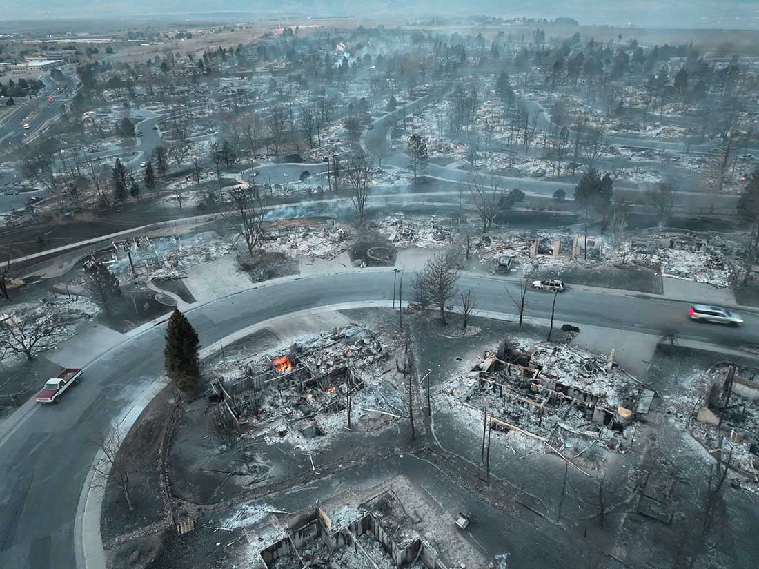
Early Friday morning, about 20 hours after the Marshall Fire ignited, a drone operated by Twitter user WxChasing/Brandon Clement flew over subdivisions that were devastated by the December 30 fire. It found block after block of ash piles, some still smoldering. In many scenes there was scarcely a structure still standing. (Scroll down to see the video.)
All of the reasons why some houses did not burn even though dozens around them were consumed could not be determined from the video, but there was one common feature — the survivors were more distant from the neighboring homes. Many houses in the subdivisions were only 10 to 20 feet apart based on archived imagery in Google Earth.
The fire was driven by very strong winds gusting at 60 to 100 mph, extremely dry conditions after months of drought, and relative humidity in the mid-20s. These are the very worst fire conditions. The weather paired with the nearly back to back structures led to the fire spreading through a continuous human-made fuel bed. When one house burned the convective and radiant heat easily ignited its neighbor, which ignited its neighbor, etc.
The fire in the vegetation and structures lofted burning materials far downwind, creating distant spot fires in the home ignition zone on bone dry lawns, mulch beds around ornamental plants, and on structures. It is unknown at this point how many had been designed and built to be fire resistant, such as the characteristics of the roof, vents, siding, doors, windows, foundation, fences, eaves, and decks. A FEMA publication (13 MB) has excellent detailed recommendations. Headwaters Economics found that the cost of building a fire-resistant home is about the same as a standard home. Local building codes could regulate these features. But if the lot size is so small that residences are only 10 to 20 feet apart, if one becomes fully involved, the neighbors also burn, especially during windy conditions.
So far we have listed some factors that affect the vulnerably of structures during a wildland-urban interface fire: home spacing and lot size, the envelope of the structure itself, fire codes, and the home ignition zone. Others are:
Safety zones where residents can shelter in place;
Road and driveway width, wide enough for large fire trucks;
Turnarounds at the end of roads;
Signage, and;
Emergency water supply.
The video below of the Marshall Fire devastation was shot by WxChasing/Brandon Clement at first light on December 31, 2021, the day after the fire started. Not long after, snow began falling. The National Weather Service in nearby Boulder recorded an accumulation of eight inches.
The fire destroyed hundreds of homes southeast of Boulder, Colorado
Updated at 3:47 p.m. MST Dec. 31, 2021
Photo from a traffic camera in Boulder, CO at 3:44 p.m. Friday. Credit: city of Boulder.
Judging from the photo above taken in Boulder, Colorado at 3:44 p.m. the weather forecast was correct. Forecasters are predicting an additional six inches or so through noon Saturday in the area of the Marshall Fire.
Updated 12:40 p.m. MST Dec. 31, 2021
Boulder County Sheriff Joe Pelle said in a briefing Friday morning that there have been no reports of fatalities on the 6,025-acre Marshall Fire southeast of Boulder, Colorado. That could change as crews assess the impacts of the fire, but if the number remains at zero, it would be very remarkable considering the rapid spread of the blaze which allowed some residents only minutes to escape. It is also a testament to the amazing job done by firefighters and law enforcement to make the necessary notifications, which no doubt saved lives.
Friday morning there is very little remaining fire activity, other than smoldering remains of destroyed structures. Firefighters do not expect the perimeter to grow, especially in light of the snow in the forecast.
The one person reported as missing has been found.
There are 1,778 homes within the perimeter of the fire, but not all of them were affected by the fire, which burned in a mosaic pattern. Some entire subdivisions were “totally gone,” the Sheriff said, including the the Sagamore subdivision just west of Superior and the Old Town Superior area. Dozens more burned homes are west of Superior in the Marshall area, and on the south side of Louisville.
Governor Jared Polis and the Sheriff said Friday that there could be as many as 500 to 1,000 homes that were destroyed. That could be an increase from the estimated 580 figure released by the Sheriff Thursday evening. There were also a number of commercial properties damaged or destroyed.
As entire subdivisions were wiped out, many household plumbing systems were also damaged or destroyed, which led to water gushing from the remains of structures. This depleted the water available at fire hydrants which became a challenge for firefighters. Louisville residents were advised to either boil their water or use bottled water for drinking, making ice, and other uses because the city changed its water distribution to untreated water in its efforts to make water available to firefighters. Other communities with boil water advisories include Superior, Louisville, San Souci Mobile Home Park, East Boulder County Water District, and the Eldorado Artesian Spring water users.
President Biden has approved a disaster declaration which will be finalized Friday. This will expedite approvals of assistance for home owners and small businesses that suffered losses.
Sheriff Pelle said the wind blew down power lines near the point of origin of the fire, but the specific cause has not been confirmed.
On Friday about 200 people were staying in emergency shelters.
The Incident Commander said the strategy during the first few hours was not to attempt to suppress the fire, but the priority was life safety, notifying residents and implementation of the evacuation. With 50 to 100 mph winds, suppression would have been futile. Later when the evacuation was complete and the wind speeds had decreased, they were able to begin working on the flanks.
The Sheriff said “a federal incident commander” will be relieving the IC that has been running the fire since Thursday morning. This sounds like an interagency incident management team (IMT) has been ordered. The National Situation Report dated 7:30 Friday morning lists no fires in Colorado or the assignment of any IMTs. This is an oversight at the National Interagency Fire Center, which is no doubt working with a skeleton staff during the holidays.
The map of the fire was updated late Friday morning, increasing the size by 20 acres, bringing the total up to 6,025. The tweaks were minor and involved a few changes in the perimeter south of Marshall Lake and on the east side near the intersection of Dillon Road and S. 96th Street.
Overnight mapping Thursday night found that the Marshall Fire southeast of Boulder, Colorado had burned about 6,000 acres. The fire started at 10:30 Thursday morning and was pushed by wind that in some areas gusted up to 100 mph while the relative humidity was in the 20s. Tens of thousands of residents have been under evacuation orders. At least 580 homes, a shopping center, and a hotel burned. That number will increase in the coming days as authorities are able to access the area.
Evacuation areas, Marshall Fire. Map accessed at 6:30 a.m. Dec. 31, 2021. More details.
All patients were evacuated from the Avista Adventist Hospital in Louisville. The Good Samaritan Medical Center in Lafayette transferred about 54 of their most critical patients to other facilities.
No deaths have been reported, but at 5 p.m. Thursday Boulder County Sheriff Joe Pelle said, “Due to the magnitude of this fire, the intensity of this fire, and its presence in such a heavily populated area we would not be surprised if there are fatalities.”
Thursday afternoon the Target shopping complex and the Element Hotel in Superior were burning.
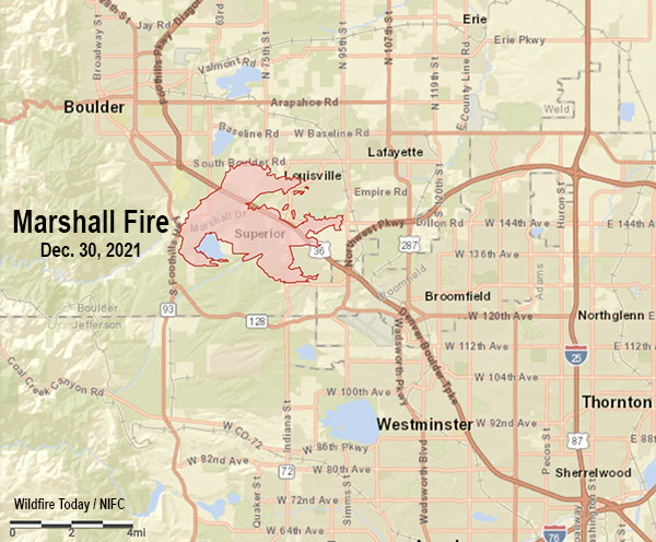
Vicinity Map, Marshall Fire, Dec. 30, 2021.
Fire officials said the cause of the fire was likely downed power lines during the extreme winds.
The weather has changed for the better, as least from a firefighting viewpoint. The 50 to 100 mph winds with low humidities are being replaced Friday morning with temperatures around freezing and a 40 percent chance of snow. By 11 a.m. that chance will increase to 76 percent, then 96 percent by sunset. Snow accumulations are predicted to be 0.6 inch during the day on Friday, with another 5 inches overnight and into Saturday morning. The wind Friday will be out of the north switching to the east at 7 to 9 mph gusting in the afternoon to 16 mph. We don’t often include wind chill in our articles about ongoing wildfires, but that will be a factor today, 250 dropping to 17o by 5 p.m.
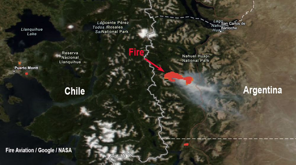
Large fires are currently burning in Colorado and Argentina
While 580 homes are burning in the Marshall Fire near Boulder Colorado, 6,000 miles to the south firefighters are battling numerous wildfires in Argentina. This is not common.
The video below is from the Associated press.
A helicopter under contract to the government of Argentina crashed Wednesday, Dec. 29 while working on a wildfire in the Patagonia region of the country according to local press reports. The two on board, a pilot and a mechanic, were killed.
At least 580 homes have burned in the Marshall Fire
Updated at 8:23 p.m. MST Dec. 30, 2021
Map showing heat on the Marshall Fire detected by satellites at 2:05 p.m. MST Dec. 30, 2021.
To see all articles on Wildfire Today about the Marshall Fire, including the most recent, click here.
Evacuation Map for the Marshall Fire, accessed at 8 p.m. Dec. 30, 2021. Boulder County. More details.
The Element Hotel in Superior, CO burned:
Structures burn, including an Element Hotel, as a wind-driven wildfire forced evacuation of the Superior suburb of Boulder, Colorado. Photo by Trevor Hughes/USA TODAY NETWORK pic.twitter.com/3Te1fwEkMc
At a 5 p.m. briefing Boulder County Sheriff Joe Pelle said he was not aware of any fatalities that had occurred at that point on the Marshall Fire, which has burned approximately 1,600 acres southeast of Boulder, Colorado. One officer has been injured. (see maps below)
“However,” he said, “I would like to emphasize that due to the magnitude of this fire, the intensity of this fire, and its presence in such a heavily populated area we would not be surprised if there are fatalities.”
The Sheriff listed the numbers of structures that had burned at the time of the briefing. The numbers, totaling about 580, are approximate:
370 homes in the Sagamore subdivision just west of Superior,
210 homes in the Old Town Superior area,
The Target shopping complex in Superior was on fire,
The Element Hotel in Superior was “fully engulfed”.
Sheriff Pelle said the Middle Fork Fire 5 miles north of Boulder near Highway 36 was reported at about 10:30 Thursday morning. The spread has been stopped.
The Marshall Fire, still vigorously spreading, started just after 11 a.m. Thursday.
Three evacuation centers are available: North Boulder Recreation Center, Longmont Senior Center, and the YMCA in Lafayette. Cots are on their way and authorities are arranging for meals. Large animals should be taken to Jefferson County Fairgrounds, 15200 W. 6th Ave., Golden, CO 80401. The Boulder County Fairgrounds was reported to be full Thursday afternoon.
Weather Forecast
The forecast for the fire area Thursday night is for partly cloudy skies with a low around 27. The wind speeds will be decreasing through the night, with a south-southeast wind 19 to 24 mph becoming southwest 10 to 15 mph after midnight. Winds could gust as high as 37 mph.
On Friday snow is expected after 11 a.m. The temperature will rise to 34 by noon, then fall to around 27 during the remainder of the day. The wind will be west-southwest at 7 to 11 mph becoming east-northeast in the morning. Winds could gust as high as 18 mph. The chance of precipitation is 80%. New snow accumulations of 1 to 3 inches are possible.
The National Weather Service posted this list of maximum wind gusts in Boulder County today.
Highest wind gusts reported in Boulder County, Dec. 30, 2021. (Each line is a separate weather station.)
Updated at 4:42 p.m. MST Dec. 30, 2021
Map showing heat detected by satellites on the Marshall Fire, 2:05 p.m. MST Dec. 30, 2021.
We now have a better map of the Marshall Fire (above), based on heat detected by satellites at 2:05 p.m. MST December 30.
Marshall Fire evacuation information. Boulder County. 4 p.m. Dec. 30, 2021.Marshall Fire, posted at 4:29 p.m. Dec. 30, 2021 by @KyleClark.Marshall Fire, posted at 1 p.m. Dec. 30, 2021 by @BouldeJeff.
A helicopter under contract to the government of Argentina crashed Wednesday, Dec. 29 while working on a wildfire in the Patagonia region of the country according to local press reports. The two on board, a pilot and a mechanic, were killed.
The Bell 412 helicopter went down near Quillen, a lake in Neuquen province.
More than 200 personnel are assigned to the fire which has burned 9,900 acres (4,000 hectares) in or near Nahuel Huapi National Park.
The Federal Council of the Environment (Cofema) of Argentina and the Argentine Ministry of the Environment have declared an emergency throughout Argentina for the last 12 months due to drought and the risk of fires.
We send our sincere condolences to the family, friends, and co-workers of the two firefighters.
Air Tanker 861 (N803NZ) drops on the Oak Fire Dec. 27, 2021. Still image from West Metro Fire video.
Monday afternoon December 27 a fire southwest of Denver burned 152 acres and prompted evacuations.
The Oak Fire was reported around 2 p.m. southwest of Columbine, southwest of the C470 highway which was temporarily closed. West Metro Fire said it started near the C470/Kipling intersection west of the Westerly Apartments in an open space area with several trails and heavy foot traffic. The specific cause is still under investigation. The evacuations were cancelled Monday evening.
Oak Fire, on the southwest side of Denver, Dec. 27, 2021. Photo by West Metro Fire.
A single engine air tanker from CO Fire Aviation was mobilized from Fort Morgan, Colorado, flown by the company’s Chief Pilot Chris Doyle. It took off at 3:46 p.m. and 20 minutes later landed at Northern Colorado Regional Airport NCRA near Fort Collins to get a load of plain water which took about 10 minutes. It then made the 19-minute flight south to the fire where it quickly sized it up, dropped the water just before sunset, and returned to NCRA.
Flight path of Air Tanker 861 (N803NZ) while working the Oak Fire Dec. 27, 2021. FlightAware.
The fire was driven by strong winds. Buckley Air Force Base on the east side of Denver recorded 22 to 28 mph out of the south with gusts to 35 while the relative humidity was in the high 20s with the temperature in the high 30s. However it was cooler on the other side of the city at a higher elevation near the fire, judging from the ice photographed on the air tanker’s landing gear.
Ice on the landing gear of Air Tanker 861 after dropping water on the Oak Fire, Dec. 27, 2021. Photo by Chief Pilot Chris Doyle.
Firefighters always get a lot of satisfaction conducting a mobile attack, as seen in the videos below. An engine drives near the edge of the fire while one or two firefighters operate nozzles while walking, sometimes one in front of the engine and another picking up what’s left behind the truck. Or a second engine could followup, making sure all the heat near the edge is extinguished.
The #OakFire has slowed somewhat, but it’s still being driven by strong winds. There are no air resources available in the region. Neighboring fire districts are assisting on the ground. Two buildings at the Westerly Apts have been evacuated. 1/2 pic.twitter.com/XwmpxkR8cW