Do we need a new paradigm for protecting iconic groves of remaining giant sequoias?

Can we prevent the annual loss of 10 percent of the giant sequoias

Firefighter on the Windy Fire burning giant sequoia tree
Firefighter on the Windy Fire applies water on a burning giant sequoia tree. Photo uploaded to InciWeb Oct. 11, 2021.

In 2020, 10 to 14 percent of all giant sequoias across the tree’s natural range in the Sierra Nevada that were at least four feet diameter were killed in the Castle Fire when a substantial proportion of all sequoia groves touched by the fire burned with unprecedented severity.

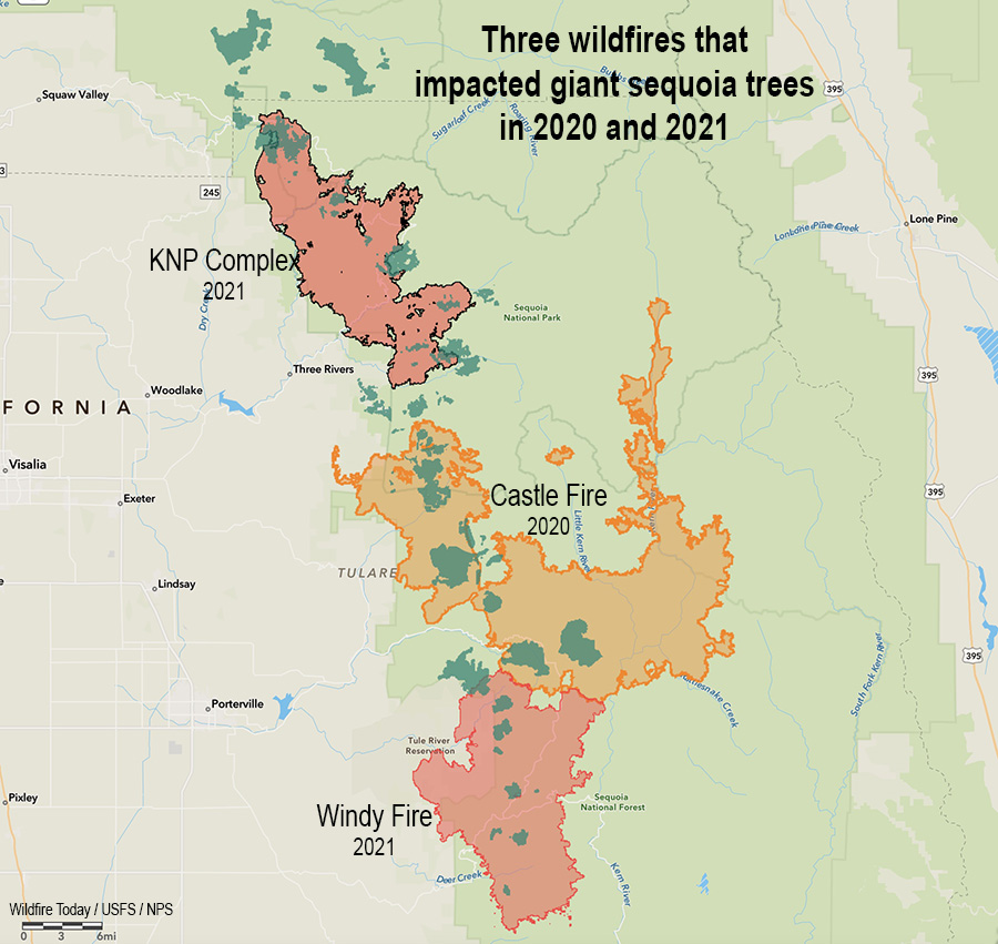
There are two fires currently burning which are destroying more of these iconic beasts of trees, the KNP Complex just north of the Castle Fire, and the Windy Fire which has spread into the south side of the Castle Fire. These three fires were primarily in the Sequoia and Kings Canyon National Parks and the Sequoia National Forest.

Three Fires, giant sequoia trees
Three fires in two years that killed giant sequoia trees. The green areas represent groves of giant sequoias.

According to a very preliminary estimate by the KNP Complex incident management team which was later removed from Facebook, “hundreds” of the iconic trees may have been killed in one day, October 4, in the Redwood Mountain Grove, the largest giant sequoia grove on Earth.

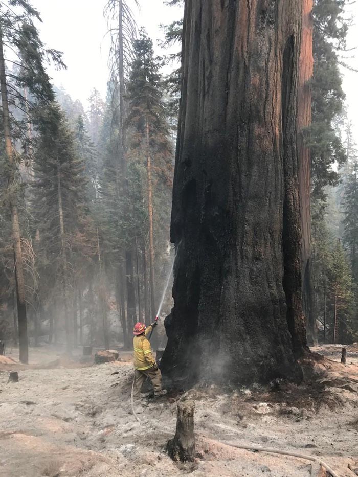
Under normal conditions giant sequoia trees can live for more than 3,000 years, which is 38 times the life expectancy of a human in the United States. The multi-year drought and higher temperatures have led to extremely dry fuel moistures which is causing wildfires in California and other areas to burn with unusual intensity, making even some of the giant sequoias with bark up to a foot thick susceptible to wildfires burning under these conditions.

KNP Complex of fires. Giant sequoias
KNP Complex of fires. Giant sequoias in the Giant Forest, posted Sept. 19, 2021. InciWeb.

It will take a few years for the final death toll to be determined in the Castle Fire, but a report released June 25, 2021 estimating the mortality found that areas which burned with high intensity, which was 30 percent of the Castle Fire grove areas, killed many giant sequoias. Below are the mortality and survival numbers from the report for the Alder Creek Grove, which shows 97.3 percent mortality in high fire severity areas, and 55.1 percent in moderate severity locations.

Giant Sequoia mortality, Alder Creek Grove, Castle Fire, 2020. NPS.

The early data for the 2020 Castle Fire translates to an estimated loss of 7,500 to 10,600 large sequoias (those with trunk diameters of four feet or more).

It could be many months or up to a year before a complete inventory determines the additional giant sequoia mortality from the fires in 2021, the Windy Fire and KNP Complex.

On October 12 the US Forest Service reported that in the Windy Fire all but four mature giant sequoias were killed in one of the smaller groves, Starvation Creek, which according to earlier information had about 30 mature sequoias. Three other groves, the FS said, had less severe damage, and four still have not been evaluated and may not be until Spring or Summer of 2022. This information only applies to the Sequoia National Forest and Giant Sequoia National Monument, and does not include the Sequoia and Kings Canyon National Parks and the KNP Complex.

Probably millions of trees are killed every year in wildfires. Should we care that 10,000 or so extremely large ones were wiped out in 2020, with trunk diameters that exceed 20 feet, that can be more than 300 feet in height and live more than 3,000 years?

These big trees are a link with our past. They represent the fact that some living things can thrive for a very long time if no one comes along to totally screw things up.

What can be done?

Fix the climate? It won’t happen quickly. The reality is that even if all of the industrialized nations overnight adopted climate-friendly policies and practices, it could be decades before CO2 and other climate gasses would decrease to the point where the climate would begin to return to pre-1850 conditions.

Harden the giant sequoia groves? Reducing the ground and ladder fuels beneath the huge trees can make them more resistant to fire. The Sequoia and Kings Canyon National Parks have been treating many of the groves with prescribed fire since the 1960s. The Sequoia National Forest also has an active prescribed fire program. But the federal agencies have not had the funding and personnel to conduct thinning and prescribed fire projects in all of the groves. And California air quality regulations and residents who complain about smoke from prescribed fires restrict the windows for when the burns can take place.

Rethink the way limited firefighting resources are allocated to going fires? In a September 23, 2021 public briefing, one of the Operations Section Chiefs on these fires explained that he did not have enough hand crews and other resources to be able to work on all of the high priority areas on his fire at the same time, and was forced to shift them around based on fire activity. It sounded like Whack-A-Mole. This was due at least in part to the numerous ongoing fires, which were competing for the same resources. Other fires had similar shortages and unfilled resource orders.

We asked Rebecca Paterson, a Public Affairs Specialist for Sequoia and Kings Canyon National Parks, if all of the resource requests or orders placed by the incident management team had been filled would there have been less giant sequoia mortality?

“It would be impossible for us to determine what could have been and we do not want to speculate,” Ms. Paterson replied.

The role of Multi-Agency Coordinating Groups in allocating scarce firefighting resources

We also asked Ms Paterson, “Beyond placing resource requests and orders, was anything else done in an attempt to procure additional resources? Such as conversations by high-ranking NPS and USFS personnel with regional and national level entities or the National Multi-Agency Coordinating Group (NMAC)?”

Ms. Paterson: “The NPS representative to the National Multiagency Coordinating Group was aware of the competing resource needs across multiple geographic areas during Preparedness Level 4 and had daily contact with the Southern California Geographic Area as their NMAC liaison. NMAC makes resource allocations to geographic areas not specific incidents. The geographic areas then assign resources to incidents. We do not know what conversations may have occurred within the United States Forest Service.”

The Operating Plan for the NMAC sets the priorities for the group when allocating resources:

  1. Protection of human life.
  2. Maintain initial attack capability.
  3. Protect communities and community infrastructure, other property and improvements, and natural and cultural resources.

The 2021 Multi-Agency  Coordination System Procedure Guide for FIRESCOPE California uses a point system for establishing priorities for resource allocation among incidents. The maximum score is 60 for each fire. Only up to 5 points can be attributed to “Natural Resources (Threatened and Endangered Species Habitat, Watershed, Forest Health, Soils, Air Shed, etc.).” Up to 15 points can be assigned to structures and infrastructure.

It is probably safe to assume that when multiple large fires are burning most of the priorities for allocating scarce resources are decided by individuals with a history of on the ground firefighting. They may or may not have a bias toward assigning fire personnel to protect buildings, rather than fires where 3,000-year old trees 300 feet tall and 20 feet in diameter are being destroyed.

Today, the last giant sequoias on Earth live on land the size of Cleveland (48,000 acres) in about 73 groves scattered along the western slopes of the Sierra Nevada. The northernmost grow in Placer County in Tahoe National Forest, and the southernmost groves are in Giant Sequoia National Monument. They need a great amount of water and depend on the Sierra snowpack that accumulates over the winter months and soaks into the ground when it melts. Years of drought, declining snowpack, and increasingly intense wildfires are putting the species at greater risk.

If these massive plants were able to already live for thousands of years, it is irresponsible to not ramp up our efforts to protect them when human-caused climate change is suddenly leading to the destruction of large segments of their populations, 10 to 14 percent last year alone.

As we get deeper into the bowels of climate change it is going to be increasingly difficult to maintain the status of all living things on the planet, except for cockroaches, Keith Richards, and Clint Eastwood.

The Bottom Line

Since only approximately 100,000 of these mammoth trees are left that are larger than four feet in diameter, government employees allocating firefighting resources need to strongly consider their value to the nation and the world, and that some of them have been living for thousands of years. It is disheartening to see hundreds of them destroyed in a matter of hours, especially if due in part to sending resources, instead, to in some cases protect structures that have not been hardened to FireSafe standards or constructed under reasonable county and city building codes.

We need to continue to manage the fuels beneath these big trees, and redouble the prescribed fire programs around them that began in the 1960s. Congress and the President need to increase the fuel management funding for Sequoia and Kings Canyon National Parks, Sequoia National Forest, and Giant Sequoia National Monument to make this possible.

flames fire giant sequoia Windy
Flames spread around a large tree on the Windy Fire. Mike McMillan, BIA. Uploaded to InciWeb Sept. 22, 2021.

Prescribed fire escapes near Watsonville, CA, evacuations ordered

Mapped at 83 acres Saturday morning

9:17 p.m. PDT Oct. 16, 2021

At 6:17 p.m. Saturday CAL FIRE revised the reported size of the Estrada Fire, increasing it from 83 acres to 148, saying the new number was the result of “accurate ground truthing and mapping.”

Firefighters will again work through the night Saturday to establish strong control lines.


11:09 a.m. PDT Oct. 16, 2021

Estrada Fire map
Estrada Fire map. The red dots represent heat detected by a satellite at 2 a.m. PDT Oct. 16, 2021.

A prescribed fire intended to treat 20 acres grew out of control Friday, prompting evacuations in Central California.

The project was initiated by the California Department of Forestry and Fire Protection near the intersection of Hazel Dell and Hidden Canyon Road six miles northeast of Watsonville, California. After escaping the planned burn unit boundary it spread quickly, growing to 83 acres by Friday evening, when CAL FIRE said aircraft had established a line of fire retardant around the perimeter.

“Ninety-nine percent of the time these things go off without a hitch,” said Ian Larkin, CAL FIRE Chief for the San Mateo Santa Cruz unit. “No problems, they don’t get out of control, they don’t jump our containment line…The reason we did this yesterday was we had a prescription level of good weather, it was in prescription, and it was an ideal situation for us to be able to get good consumption of the fuel, and we just had this mishap. It was about 80 to 100 feet of tying it all in and we had a spot take off across the line.”

At 7:17 Saturday morning CAL FIRE said crews made significant progress overnight.

Estrada Fire
Estrada Fire, seen by the Mt. Madonna camera at 4:10 p.m. Oct. 15, 2021, looking southeast.

Evacuation orders were still in effect at 10:48 a.m. PDT October 16. (Evacuation map)

The video below, at 0:50, shows a fire whirl that is persistent, in spite of the water being applied from a fire hose.

Thanks and a tip of the hat go out to Pat.

Smoke from Alisal Fire triggers air quality advisory for Southern California

The smoke will worsen Thursday afternoon and evening

Wildfire smoke forecast, Southern California
Wildfire smoke forecast for 7 p.m. Oct. 14, 2021. NOAA.

Residents along the Southern California coast are seeing the effects of the Alisal Fire in the air they are breathing. On Thursday the South Coast Air Quality Management District issued a special air quality advisory for smoke that will be worsening during the afternoon.

Heavier concentrations of the smoke are expected to move into the counties of Orange, Riverside, San Bernardino, and L.A. Thursday afternoon and evening.

The Alisal Fire has burned more than 16,000 acres 19 miles west of Santa Barbara.

More evacuations ordered for the Alisal Fire in Southern California

The blaze has grown to 16,801 acres

Alisal Fire map, 9:30 p.m. PDT Oct. 13, 2021
Alisal Fire vicinity map. The red line was the perimeter at 9:30 p.m. PDT Oct. 13, 2021. The white line was the perimeter about 24 hours earlier. Scroll down to see a more detailed map.

On Wednesday the Alisal Fire, 11 miles west of Goleta, California spread two miles further west and one mile to the east. On the east side it is still spreading through the five year old footprint of the Sherpa Fire.

Air tankers took advantage of decreasing winds Wednesday to apply retardant on the north side, reinforcing the West Camino Cielo road out to Gaviota on the west side. Crews conducted a firing operation along the road later in the afternoon.

Alisal Fire, retardant applied
Looking east at the Alisal Fire; retardant applied on the north side of the fire near West Camino Cielo road Oct. 13, 2021. Air Attack photo.

Additional evacuations were ordered Wednesday night for the area west of Arroyo Hondo to the intersection of Hwy. 101 and Hwy. 1, including Vista Del Mar School and Gaviota Beach. The ranch formerly owned by President Ronald Reagan, known as the Western White House, is also under evacuation orders. (More information about evacuations.)

To see all articles on Wildfire Today about the Alisal Fire, including the most recent, click HERE.

Thursday morning fire officials said the fire had burned 16,801 acres. Resources assigned to the fire Wednesday evening included 31 hand crews, 143 engines, and 8 helicopters for a total of 1,306 personnel, an increase of 541. Management of the fire has transitioned to a California Type 1 Incident Management team led by Jerry McGgowan.

Alisal Fire map, 9:30 p.m. PDT Oct. 13, 2021
Alisal Fire map. The red line was the perimeter at 9:30 p.m. PDT Oct. 13, 2021. The white line was the perimeter about 24 hours earlier. The red dots represent heat detected by a satellite at 1:48 a.m. PDT Oct. 14, 2021.

On Thursday firefighters are going to be faced with wind directions shifting about every six hours. Southwest winds are likely to develop in the morning, which may turn southeasterly in the early afternoon, before becoming northwesterly Wednesday evening. The relative humidity will be in the low 20s, but will rise to the mid-50s Wednesday night. Light and mostly onshore winds are in the forecast for Friday.

Alisal Fire
Alisal Fire, seen from Santa Ynez Peak, looking west-southwest at 7:04 a.m. PDT Oct. 14, 2021.
Alisal Fire map, 9:30 p.m. PDT Oct. 13, 2021
Alisal Fire map, 3-D looking east. The red line was the perimeter at 9:30 p.m. PDT Oct. 13, 2021. The white line was the perimeter about 24 hours earlier.
Alisal Fire map, 9:30 p.m. PDT Oct. 13, 2021
Alisal Fire map, 3-D looking west. The red line was the perimeter at 9:30 p.m. PDT Oct. 13, 2021. The white line was the perimeter about 24 hours earlier.

Below is a timelapse video of the Alisal Fire — about five hours compressed into 30 seconds. It was shot by the AlertWildfire camera on Santa Ynez Peak, looking west-southwest, from 2:20 p.m until 7 p.m., October 13, 2021.

Charred landscape at the Alisal Fire
Charred landscape at the Alisal Fire, off Refugio Road, Oct. 13, 2021

In Congressional hearing Forest Service Chief Randy Moore recommended improved pay for federal wildland firefighters

He was asked about the Tamarack Fire which was not aggressively attacked for 13 days

2:27 p.m. PDT Oct. 13, 2021

USFS Chief Randy Moore
USFS Chief Randy Moore during Sept. 29, 2021 Congressional hearing.

In a Congressional committee hearing September 29 the new Chief of the U.S. Forest Service hit a lot of the right notes in his testimony. It was before the House of Representatives Agriculture Committee’s Subcommittee on Conservation and Forestry. The hearing was titled, “The 2021 Wildland Fire Year: Responding to and mitigating threats to communities.”

In his prepared statement, Chief Randy Moore, apparently standing in front of a real or virtual photo of Mt. Shasta topped by lenticular clouds, said “America’s forests are in a state of emergency and it’s time to treat them like one.”

He spoke for several minutes about issues related to the status of federal wildland firefighters. Here is an excerpt:

“We must maintain a stable resilient firefighting force. That starts with taking care of our brave men and women who fight fires.

“They deserve better work/life balance and benefits. They deserve a supportive workplace in return for the grueling hard work they do. At a time of increased stress, suicide, and depression they also need counseling and support services to prevent tragedy. They deserve better pay, above all. Federal wages for firefighters have not kept pace with states.

“We must also modernize our wildland fire management system. This includes improving the use of technology. It also includes upgrading our models and systems for decision making and strengthening our cooperative relationships.

“We will never hire enough firefighters, we will never buy enough engines or aircraft to fight these fires. We must actively treat forests. That’s what it takes to turn this situation around. We must shift from small scale treatments to strategic science-based treatments across boundaries. It must start with those places most critically at risk. We must treat 20 million acres over 10 years. Done right in the right places, treatments make a difference.”

Later the committee went on to talk more about firefighter pay, filling positions that are now occupied by detailers, aggressive forest management,  timber harvesting, and other issues.

An interesting but very brief discussion occurred at 1:41:08 (see the video above) when Representative Doug LaMalfa of California’s 1st Congressional District (Oroville) asked the Chief about a report of difficulties in the working relationship between the Forest Service and CAL FIRE that surfaced during the Caldor Fire west of South Lake Tahoe according to 60 Minutes September 26, 2021.

“I think I have different information than you do, Congressman,” the Chief said. “I am not aware of any problems between the Forest Service and CAL FIRE. As I indicated earlier that relationship is really solid. So, I am not aware of anything that might be going on.”

Earlier Representative LaMalfa tried to get the Chief to say the Forest Service is committed to aggressive initial attack on new fires, but the Chief preferred to use the term “aggressive forest management.” (He later said that they already do aggressive initial attack.)

Representative LaMalfa asked about the Tamarack Fire near Markleeville, CA which started as a single tree on July 4, 2021 and was monitored but not suppressed for 13 days while it was very small until it suddenly grew very large. It burned at least 15 structures and more than 67,000 acres as it ran from California into Nevada jumping Highway 395 and prompting the evacuation of 2,000 people.

In the hearing Chief Moore said that after the fire started the Forest Service “spiked out a small crew to monitor” the fire. If that was the case, they apparently took no action, because the USFS reported on July 10 that it was 0.25 acre, they were not going to insert crews due to safety concerns, and it “posed no threat to the public, infrastructure, or resource values.”

In describing the situation, the Chief said that when the Tamarack Fire started on July 4 there were 100 large wildland fires and 27,000 fire personnel had been deployed. “We would have loved to have had enough crews to put on that fire,” the Chief said. “What we should be talking about is a very active forest management program. There will always be situations where you can second guess decisions that were made.”

The national Situation Report from July 5, 2021 shows that there were only 33 large uncontained fires at the time and 7,652 personnel had been mobilized. On July 22 the incident management team working on the Tamarack Fire reported that 1,200 personnel were assigned to the fire.

Alisal Fire burns to the ocean, then spreads east

14,500 acres Wednesday morning, 12 miles west of Goleta, California

8:12 a.m. PDT Oct. 13, 2021

Alisal Fire map
Alisal Fire map 9:45 p.m. Oct. 12, 2021. The red line was the perimeter at 9:45 p.m. PDT Oct. 12, 2021. The white line was the perimeter at 4:12 a.m. Oct. 12. The red dots represent heat detected by satellites at 2:56 a.m. PDT Oct. 13.

Wednesday morning the Santa Barbara County Fire Department said the Alisal Fire 12 miles northwest of Goleta, California has burned 14,500 acres, an increase of 1,100 acres over the figure released Tuesday evening. The growth over the last 24 hours has been on all sides, with the exception, of course, where the fire was stopped by the Pacific Ocean on the south.

The east side of the fire has burned into Sherpa Fire of 2016. During the 9:45 p.m. mapping flight Tuesday the strong winds and low fuel moisture helped it to spread two miles into the five-year-old footprint.

To see all articles on Wildfire Today about the Alisal Fire, including the most recent, click HERE.

Highway 101, the Pacific Railroad, and Amtrak lines remain closed and evacuations are still in effect. (More information about evacuations.)

On Wednesday fire officials expect to have working on the fire 5 air tankers, 6 helicopters, and a total of 1,300 personnel.

Alisal Fire map, 9:45 p.m. Oct. 12, 2021.
Alisal Fire map, 3-D, 9:45 p.m. Oct. 12, 2021. The red line was the perimeter at 9:45 p.m. PDT Oct. 12, 2021. The white line was the perimeter at 4:12 a.m. Oct. 12.

The spot weather forecast produced for the incident calls for 5-10 mph northeast winds Wednesday morning, becoming south to southwest at 5 to 10 mph by noon, then changing to come out of the northwest after 6 p.m. at 15 to 20 mph with gusts to 35. The humidity will be in the upper teens until it begins to rise in the afternoon. The standard NWS local forecast for the area is a little different.

Alisal Fire map
Alisal Fire map, east side, 9:45 p.m. Oct. 12, 2021. The red line was the perimeter at 9:45 p.m. PDT Oct. 12, 2021. The white line was the perimeter at 4:12 a.m. Oct. 12. The red dots represent heat detected by satellites at 2:56 a.m. PDT Oct. 13.

Firefighters expect to have winds on Wednesday that will allow the use of fixed and rotor wing aircraft at least part of the day.

Firefighters on the Alisal Fire
Firefighters on the Alisal Fire, Oct. 12, 2021. SBCFD photo.

7:09 p.m. PDT Oct. 12, 2021

Alisal Fire
Alisal Fire, seen from Santa Ynez Peak, looking southwest at 5:25 p.m. Oct. 12, 2021.

The wind slowed a bit late in the afternoon Tuesday, enough to allow fixed wing air tankers to work the Alisal Fire. At one point there were three over the fire and another four at the Santa Maria Airport 31 miles to the northwest. Helicopters have also been dropping water.

Most of the air tanker activity was on the west side, which corresponds with heat detected in that area by a satellite at 2:55 p.m. PDT. A weather station on Alisal Road recorded winds coming from the north-northwest, north, and north-northeast gusting around 20 mph hour between noon and 4:20 p.m. This could have caused more growth to the west.

The 2:55 p.m. satellite data showed significant growth on both the east and west sides Tuesday.

Fire officials said Tuesday evening the fire had burned 13,400 acres, almost double the last update.

Continue reading “Alisal Fire burns to the ocean, then spreads east”