KEYT reported that the Alisal Fire burned approximately 3,000 acres by 7:30 p.m.
7:02 p.m. PDT Oct. 11, 2021
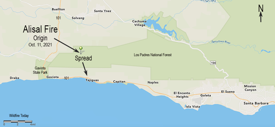
Map showing the origin location and initial spread of the Alisal Fire, October 11, 2021.
Within a few hours after it started at about 2:30 p.m. PDT Monday, very strong winds pushed the Alisal Fire three miles downhill from a ridgetop to the Pacific Ocean at Refugio State Beach west of Santa Barbara, California. Winds out of the north-northwest at 20 to 30 mph gusting to 50 drove it to Highway 101 by 5:30 p.m.
To see all articles on Wildfire Today about the Alisal Fire, including the most recent, click HERE.
Alisal Fire 3-D map, Oct. 11, 2021, looking north.
The wind was so strong that air tankers and even a mapping plane were unable to work on the fire during the initial hours.
Alisal Fire at Hwy. 101 at 5:43 p.m. Oct. 11, 2021. Via OurAirSBC
Monday afternoon the Alisal Fire was 25 miles west-northwest of Santa Barbara and 5 miles northeast of Gaviota.
Highway 101 is closed in the area and evacuations are in effect. An interactive evacuation map is available at https://arcg.is/1zO4m8. Enter your address at the top right field to determine if your area is under an Evacuation Order.
Alisal Fire, soon after it started. By Los Padres NF Air Attack. Oct. 11, 2021.
The relative humidity was surprisingly high Monday afternoon, ranging from 30 to 50 percent. The weather forecast for the fire area is for the wind to continue to be from the northwest until 10 p.m. Tuesday. The speed until 11 p.m. Monday is predicted to be 37 gusting to 49 mph, then decreasing at 2 a.m. Tuesday to 18 gusting to 24 until 10 p.m. Tuesday, after which it should drop to 5 mph out of the north. The relative humidity will peak at 71 percent at 8 p.m. Monday then steadily drop, reaching 19 percent by 2 p.m. Tuesday.
This predicted wind direction should cause the fire to spread more to the east than to the west.
Alisal Fire, looking southeast from the Refugio1 camera at 6:45 p.m. Oct. 11, 2021.Alisal Fire. Satellite photo at 5:17 p.m. PDT Oct. 11, 2021.
The blaze in Northern California destroyed 18,804 structures, most of which were in Paradise
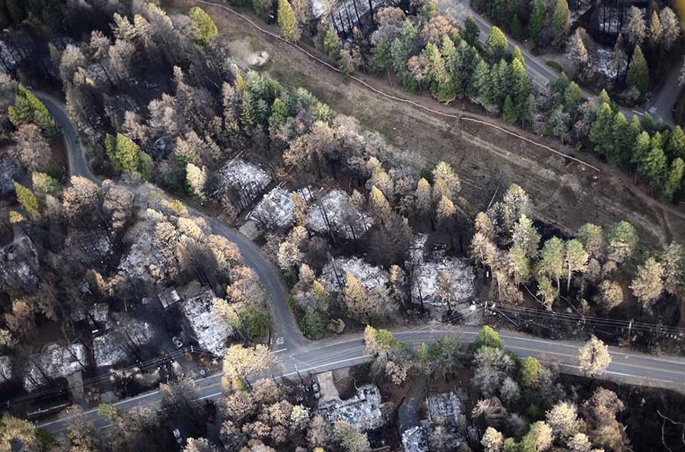
Aerial image showing a portion of Magalia just NW of Paradise, illustrating a gradient of fire damage to overstory vegetation with distance from destroyed homes. At least in some areas, burning homes may have influenced the effects to overstory vegetation more so than burning overstory vegetation influenced the outcome to homes. Photo: Owen Bettis, Deer Creek Resources.
In a paper published October 4, 2021, researchers analyzed the structures that were destroyed and those that survived the Camp Fire that ran through the city of Paradise, California in 2018. They considered at least four primary characteristics of structures:
Were they built before or after the adoption in 2008 of Chapter 7A of the California Building Code which requires certain fire resistance measures, including exterior construction materials used for roof coverings, vents, exterior walls, and decks and applies to new construction of residential and commercial buildings in designated fire hazard severity zones.
Distance to nearest destroyed structure.
Number of structures destroyed within 100 meters.
Pre-fire overstory tree canopy within 100 meters
They found that the last three criteria were the strongest predictors of survival. Homes more than 18 meters from a destroyed structure and with less than 53 percent pre-fire overstory canopy within 30 to 100 meters survived at a substantially higher rate than homes in closer proximity to a destroyed structure or in areas with higher pre-fire overstory canopy. Most fire damage to surviving homes appeared to result from radiant heat from nearby burning structures or flame impingement from the ignition of near-home combustible materials. The researchers concluded that building and vegetation modifications are possible that would substantially improve outcomes. Among those include improvements to windows and siding in closest proximity to neighboring structures, treatment of wildland fuels, and eliminating near-home combustibles, especially within 1.5 meters of the structure.
The authors noted that while 7a includes requirements not found in many building codes, a few others are more complete incorporating multiple construction classes based on anticipated radiant heat, flame, and ember exposure levels. For example Chapter 7A does not consider the interaction between components such as siding, window, and the under-eave area on an exterior wall.
There is an opportunity for much needed improvement in both current building codes and how we live in wildfire prone WUI areas.
Below is the complete Conclusion section from the research.
Conclusions
The results of this study support the idea that both proximities to neighboring burning structures and surrounding vegetation influence home survival with wildfire. Denser developments, built to the highest standards, may protect subdivisions against direct flame impingement of a vegetation fire, but density becomes a detriment once buildings ignite and burn.
Recent examples of losses in areas of higher density housing include the wind-driven 2017 Tubbs Fire in northern California, where house-to-house spread resulted in the loss of over 1400 homes in the Coffey Park neighborhood (Keeley and Syphard 2019), and the wind-driven 2020 Almeda Fire in southern Oregon, which destroyed nearly 2800 structures, many in denser areas in the towns of Talent and Phoenix (Cohen and Strohmaier 2020). Once fire becomes an urban conflagration, proximity to nearby burned structures becomes especially important because occupied structures contain significant quantities of fuel, produce substantial heat when burned, and are a source of additional embers. For density to be protective, home and other structure ignitions would need to be rare.
Fifty-six percent of homes in Paradise built during or after 2008 did not survive, illustrating that much improvement is needed in both current building codes and how we live in wildfire prone WUI areas before proximity to nearby structures becomes a benefit rather than a vulnerability. The threat posed by nearby burning structures as well as our finding of an apparent strong influence of vegetation 30–100 m from the home—a distance that in most cases encompasses multiple adjacent properties—demonstrates that neighbors need to work together to improve the overall ability of homes and communities to resist wildfire exposures.
To maximize survivability, homes need to be designed and maintained to minimize the chance of a direct flame contact, resist ember ignition, and survive extended radiant heat exposure. Our analyses demonstrating the strong influence of nearby burning structures on home survival suggests improvements to resist radiant heat exposures may be warranted in the California Building Code—i.e., increasing the standards for buildings within a certain minimum distance of other structures.
Some possible improvements might include noncombustible siding with rating minimums tied to proximity to other structures, both panes in windows consisting of tempered glass, or installation of deployable non-combustible shutter systems. Additionally, certain options for complying with Chapter 7A are better for resisting radiant heat and flame contact exposures and could minimize fire spread to other components. Whereas the International Code Council’s Wildland Urban Interface Building Code (International Code Council 2017) provides three ignition-resistant construction classes to allow for material restrictions as a function of exposure level, Chapter 7A consists of one level, so is binary in nature in that a building either needs to comply, or it does not. The Australian building code for construction in bushfire prone areas, AS 3959 (Standards Australia 2018), incorporates six different construction classes based on anticipated radiant heat, flame, and ember exposure levels. Interaction between components, for example, siding, window, and the under-eave area on an exterior wall, is not considered.
Our summary of damaged but not destroyed homes in Paradise was in line with other reports showing a high proportion of home ignitions indirectly resulting from embers (Mell et al. 2010). Embers frequently ignited near home combustibles such as woody mulch, fences, and receptive vegetative fuels with flames and/or associated radiant heat then impacting the home itself, supporting awareness of the importance of combustibles within the first 1.5 m (5 ft) of the building on home survival.
A re-interpretation of defensible space fuel modifications is needed to increase the building’s resistance and exposure to embers and direct flame contact, especially in the area immediately around a building and under any attached deck or steps. This does not diminish the value of defensible space fuel modifications 9 to 30 m (30 to 100 ft) away from the home, which not only reduces fuel continuity and the probability of direct flame contact to the home, but also provides firefighters a chance to intervene.
While our data show a relationship between home loss and vegetative fuels (high pre-fire overstory canopy cover likely associated with a greater litter and woody fuel abundance, as well as other wildland understory vegetation) that can contribute to fire intensity and ember generation, the WUI fire loss issue has been described as home ignition problem more so than a wildland fire problem (Cohen 2000; Calkin et al. 2014). The damaged home data were in line with this view, with few homes showing evidence of continuity with wildland fuels that would contribute to flame impingement, but numerous homes with near home fuels, both from manmade and natural sources, that led to direct or indirect ember ignitions.
California’s Mediterranean climate will continue to challenge its residents with regular wildfire exposure throughout the state. Whether through modifying the nearby surface and vegetative wildland fuels or the home itself, adapting to wildfire will take time. The good news is that the trend in survival is improving with newer construction practices. However, with 56% of houses built after 2008 still succumbing to the Camp Fire, much room for improvement remains.
Our data suggest it is possible to build (and maintain) buildings that have a high probability of surviving a worst-case scenario type of wildfire, even in fire-prone landscapes such as the Paradise area. Newer homes built after 1972, where the nearest burning structure was >18 m away, and fuels associated with vegetation 30–100 m from the home kept at moderate and lower levels (<53% canopy cover) had a 61% survival rate—an approximately 5-fold improvement over the Paradise housing population as a whole. Survival percentages substantially higher still are potentially possible if all components of risk, including ember generation in nearby wildland fuels, continuity of wildland and other fuels on the property, and home ignitability are sufficiently mitigated.
Citation:
Knapp, E.E., Valachovic, Y.S., Quarles, S.L. et al. Housing arrangement and vegetation factors associated with single-family home survival in the 2018 Camp Fire, California. fire ecol 17, 25 (2021). https://doi.org/10.1186/s42408-021-00117-0
Strong winds and low humidity to begin Sunday night
6:35 p.m. PDT Oct. 10, 2021
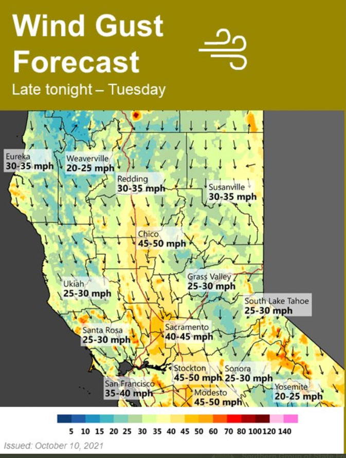
Forecast for wind gusts, Sunday night through Tuesday, Northern California. NWS Sacramento, at 1 p.m. PDT Oct. 10, 2021.
Much of California between Los Angeles and Redding will be under elevated fire danger or Red Flag Warnings Monday and Tuesday. Strong north winds are predicted to begin Sunday night, peak on Monday, and last through Tuesday. Temperatures will not be as high as is seen in typical Santa Ana wind events, but they will be higher than normal and relative humidities will be low.
In the North Bay, for example, winds will develop late Sunday evening from the north at 30 to 40 mph, and will be locally higher near favored gaps, canyons, and in the Valley. Minimum humidity will drop to 10 to 25 percent Monday and slightly lower on Tuesday. Overnight recovery will be 25 to 50 percent.
Any fires that develop could spread rapidly.
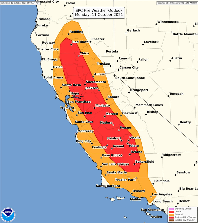
Storm Prediction Center outlook for critical fire weather, Monday, Oct. 11, 2021. Updated at 11:46 a.m. PDT Oct. 10, 2021.
Victoria Prescribed Fire, Black Hills National Forest. South Dakota. USFS photo by Matt Daigle. March, 2021.
In recent weeks there have been discussions online about whether or not fuel reduction projects can aid firefighters by reducing the intensity of wildfires. These rumblings are heard from agenda driven advocacy groups including the John Muir Project.
There is no question that properly executed and followed up fuels treatments — mechanical, or prescribed fires — can modify subsequent fire behavior and reduce a wildfire’s intensity. Despite the attention getting efforts of these groups, this has been a settled issue for a very, very long time. Indigenous people no doubt knew this, and in recent decades wildland firefighters do as well.
Scientists say climate change has made the American West much warmer and drier and will continue to make weather more extreme and wildfires more frequent and destructive, accelerating the need for more large-scale forest treatments.
Critics say forest thinning operations are essentially logging projects in disguise.
Opening up the forest canopy and leaving more distance between trees reduces the natural humidity and cooling shade of dense forests and allows unimpeded winds to push fire faster, said Chad Hanson, forest and fire ecologist with the John Muir Project.
Such reasoning defies the laws of physics, said other experts: Less fuel means less severe fire. Fewer trees means it’s more difficult for fires to leap from treetop to treetop.
In a tweet that linked to the Associated Press article, British Columbia-based fire ecologist Robert W. Gray wrote:
Another case of false equivalency: weight of published, peer-reviewed fact vs one or two counter factuals published in a single journal known for pushing pseudoscience.
During extreme weather and fuel conditions, such as strong winds and very low fuel moisture, fires can spread very quickly with a great deal of resistance to control igniting spot fires a mile ahead, and in some cases may burn rapidly through or jump across fuel reduction sites, possibly igniting structures. This can illustrate the importance of homeowners making structures fire resistant and reducing flammable material in the Home Ignition Zone.
But in less than extreme conditions, a fire that spreads into a recently completed fuels project will slow, be less intense, and will offer less resistance to control. A recent example of this was when the Caldor Fire in Northern California began to reach the South Lake Tahoe area, allowing firefighters to attack the fire more directly. In a live briefing on September 3, 2021 East Side Incident Commander Rocky Opliger complimented the agencies for the fuel treatments that had been accomplished over the years. He said the 150-foot flame lengths dropped to about 15-feet when the fire entered the treated areas. This allowed hand crews and engines to take an aggressive approach to suppress the fire and prevent structure loss. The video of the briefing is on Facebook; Mr. Oplinger’s comments about the fuel treatments begin at 34:10.
“Science” funded by agenda driven advocacy groups that has not been peer-reviewed should always be suspect. Settled science that has been proven for decades or even centuries, should be respected.
Strong winds and low humidity expected Monday and Tuesday in portions of California
Red Flag Warnings and Fire Weather Watches at 10 a.m. PDT October 9, 2021. NWS/Google.
Red Flag Warnings are in effect Saturday for areas in Colorado, Kansas, New Mexico, Texas, and Oklahoma for warm, dry, windy weather. The relative humidity could be as low as 14 percent, wind gusts to 45 mph, and temperatures in the 80s; however, these numbers could vary over this large area.
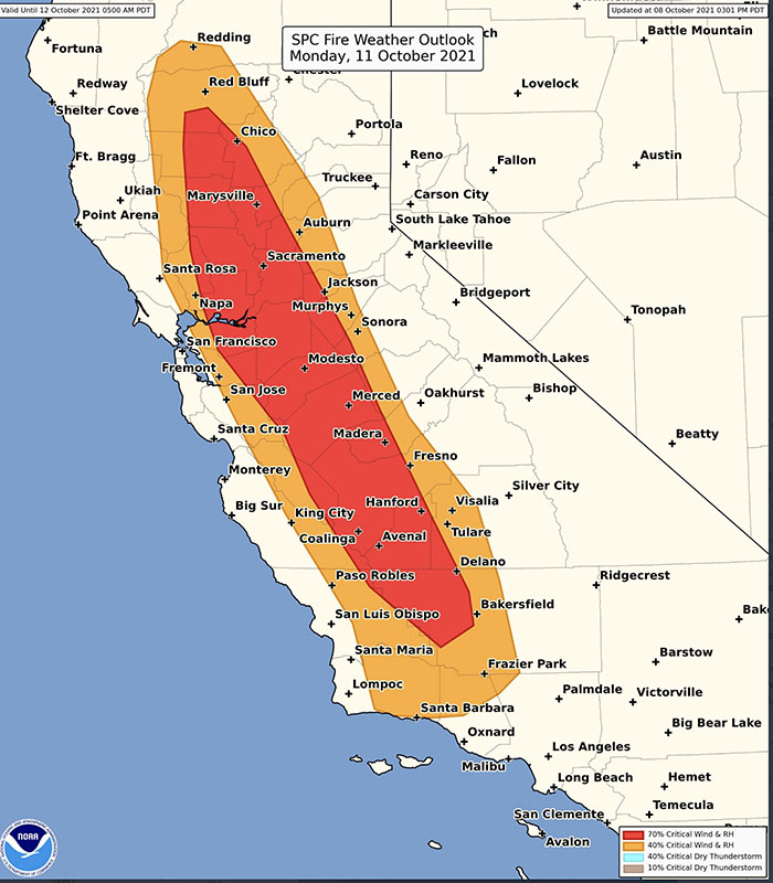
Critical fire weather for California, Monday Oct. 11, 2021.
Fire Weather Watches have been posted in California for critical fire weather. North wind gusts of 35 to 50 mph, locally higher, will develop late Sunday night and continue into Tuesday across the Central Valley and Coast Range. Strongest winds are expected along the west side of the Valley and in the Delta on Monday. North to northeast wind gusts of 30 to 40 mph, locally higher near favored gaps and canyons, will develop Monday and continue Tuesday over the foothills and mountains. The humidity will be in the 15 to 25 percent range Monday, and slightly lower Tuesday.
These weather conditions could cause wildfires to spread rapidly.
The map below shows the precipitation in California and Nevada during the 72-hour period that ended at 9 a.m. PDT October 9, 2021.
Precipitation in the 72-hour period ending at 9 a.m. PDT Oct. 9, 2021. NOAA.
Illustration of ignition of a backfire, from the US Forest Service video below.
The U.S. Forest Service has released a video — the second in the Forest News: California National Forests series. In this episode the agency examines how fuel treatment areas on National Forest System lands changed the intensity of the Caldor Fire and provided opportunities for community defense. The blaze burned more than 221,000 acres near South Lake Tahoe in August and September.
The video was written, directed, and narrated by Joe Flannery, the Acting Regional Fire Communications Team Lead in the Forest Service’s California region.