Falling tree on KNP Complex injures four firefighters

Incident Management Team said hundreds of giant sequoia trees have likely been killed in the fire, then revised their statement

11:47 a.m. PDT Oct. 8, 2021

KNP Complex of fires map, north side
KNP Complex of fires map, north side, at 9:35 p.m. Oct. 6, 2021. The green areas represent groves of giant sequoia trees. The dark red areas showed extreme heat during the mapping flight.

Four firefighters were injured by a falling tree Thursday afternoon on the KNP Complex of fires in Southern California. The Sequoia and Kings Canyon National Parks announced Thursday night that the tree struck the firefighters who were then brought to a helispot and flown to area hospitals. The injuries were serious, the Park Service said, but the personnel were all in “stable condition.” Friday morning the agency said all four had been released from the hospitals. One is an employee with CAL FIRE and three are with the California Conservation Corps.

KNP Complex of fires map, south side
KNP Complex of fires map at 9:35 p.m. Oct. 6, 2021. The green areas represent groves of giant sequoia trees. The dark red areas showed extreme heat during the mapping flight.

Tuesday, October 5, the Sequoia and Kings Canyon National Parks wrote on Facebook that hundreds of giant sequoias may have been killed in the KNP Complex of fires:

Regarding the trees, there are some groves in the park that we suspect burned at high enough intensity to result in sequoia mortality, possibly for significant numbers of trees (hundreds). However, we are currently focused on prioritization and treatment of groves that are threatened and outside the current fire footprint, as well as mopping up trees that need it. It is not safe right now, nor is it our current priority to fully assess groves that have burned. These groves will be fully assessed from the ground by resource managers when it is possible, but that will be after the fire is basically out cold and conditions allow them to get in there – likely in 2022.

On Friday morning, October 8, that October 5 statement was edited, removing the estimate of trees that may have been killed, and softening the language about assessment of giant sequoia mortality not being a priority.

We suspect that some groves in the park burned at high enough intensity to cause tree mortality. We don’t know yet the extent of the fire behavior or tree mortality. We will gain what knowledge we can with aerial reconnaissance, as smoke conditions allow. These groves will be fully assessed from the ground by resource managers when it is possible, but that will be after the fire is basically out cold and conditions allow them to get in there – likely 2022.

Dozens of media outlets reported on the “hundreds” number before it was removed.

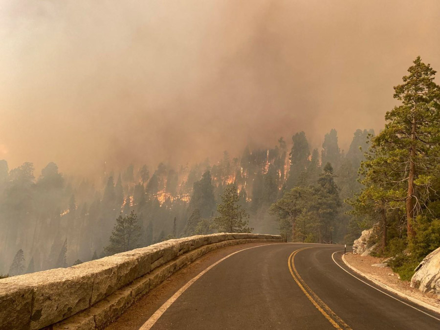
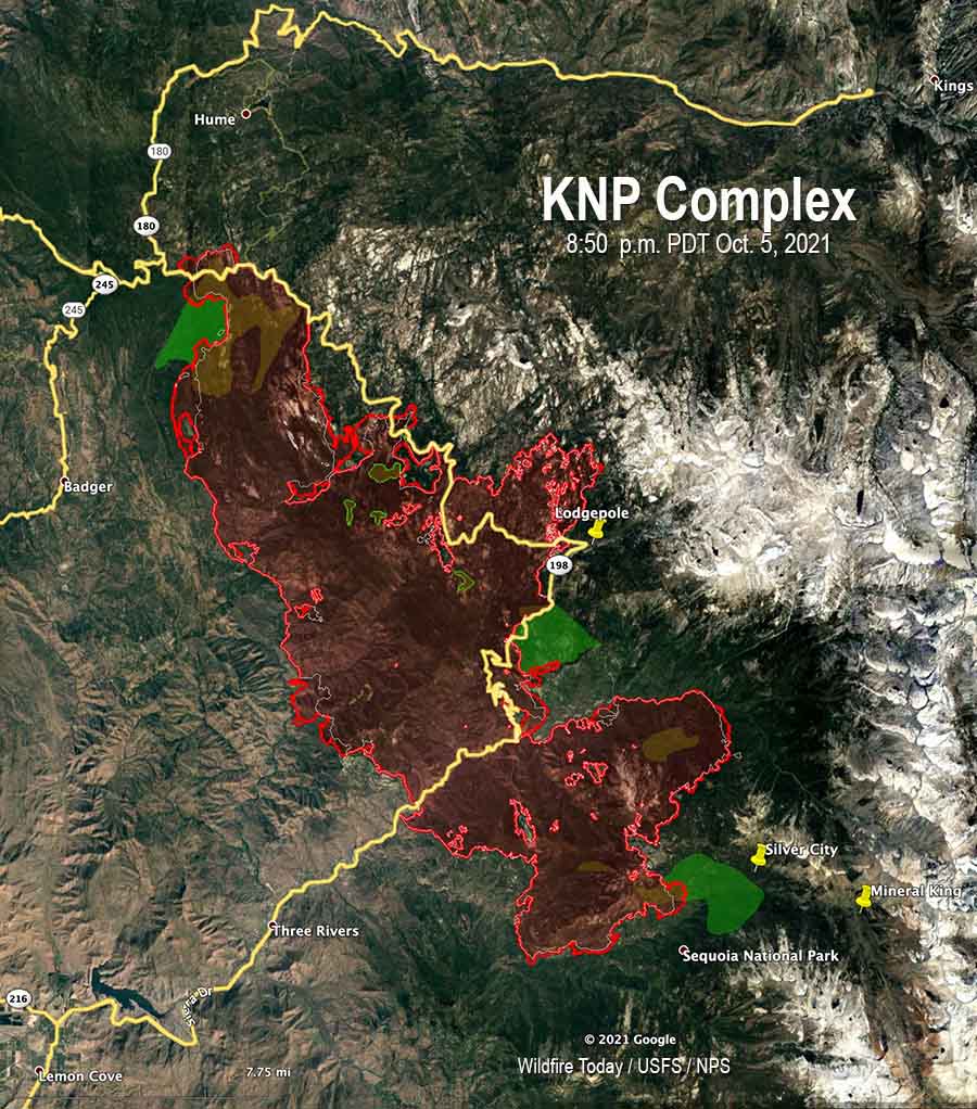
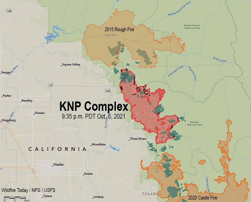
The huge 85,952-acre fire has been divided into two zones and will be managed by two Type 1 Incident Management Teams. California Interagency Incident Management Team 2 (CIIMT2) assumed command of the North Zone Thursday at 6 pm. while the Southwest Area Incident Management Team 2 remains in command of the South Zone.

KNP Complex of fires map, south side
KNP Complex of fires map, south side, at 9:35 p.m. Oct. 6, 2021. The green areas represent groves of giant sequoia trees. The dark red areas showed extreme heat during the mapping flight.

Friday morning several weather stations in the general vicinity of the KNP Complex recorded less than 0.05 inch of precipitation by 10:15 a.m. PDT. More is in the forecast during the day on Friday possibly amounting to a wetting rain of a quarter of an inch or more over the northern portions of the fire. Lesser amounts of 0.10 to 0.15 inch are likely to the south in the Mineral King and Case Mountain areas.  This is not expected to be enough to put out the fire, but it is likely to slow it down for at least several days. The forecast for Saturday and Sunday is for high temperatures in the 40s and 50s depending on the elevation, with very high humidities lowering into the 30s by Sunday. There is another chance for rain on Monday along with humidity in the 50s and 60s. Tuesday and Wednesday will be sunny with humidities of 25  to 40 percent. The wind will be generally moderate throughout this period.

All this adds up to reduced growth through Tuesday, providing opportunities for firefighters to construct direct firelines.

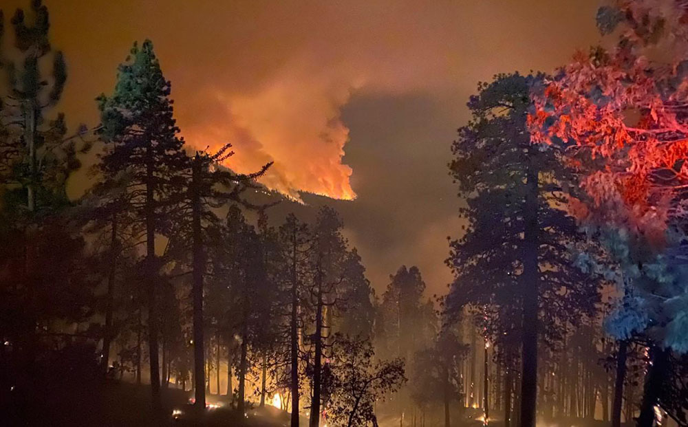
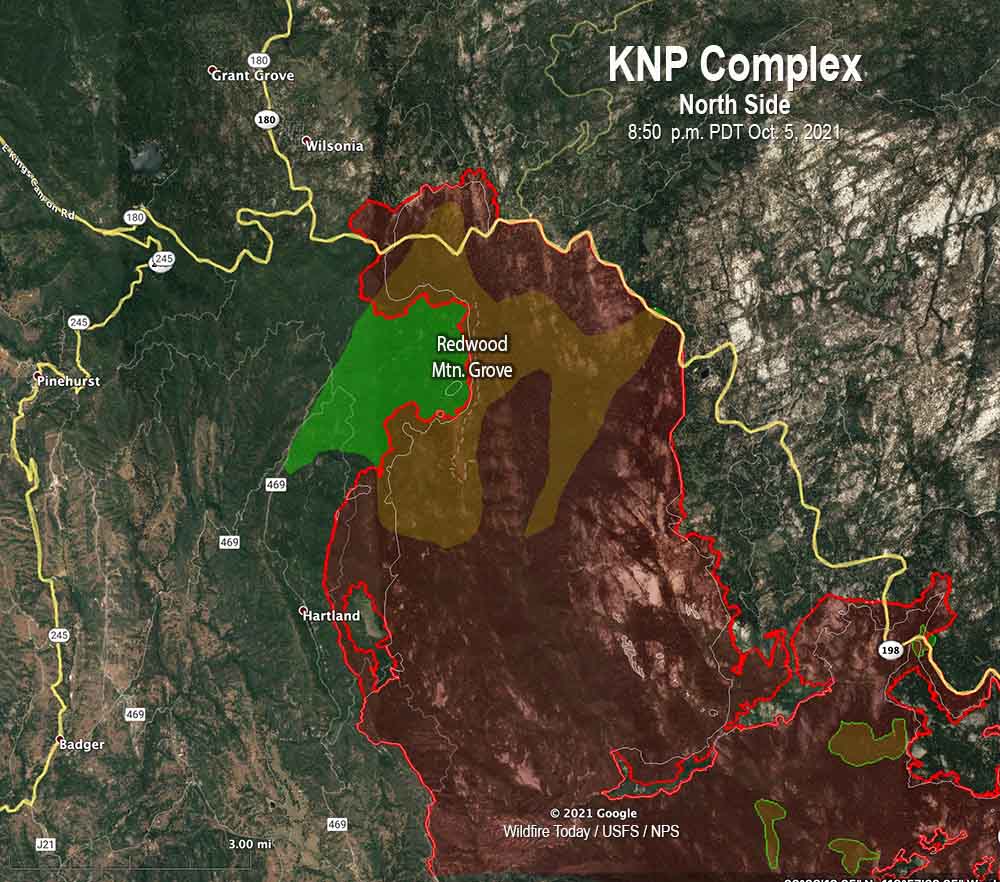
On the north zone Friday the primary focus will be the area where the fire crossed the Generals Highway south of Grant Grove. Thursday night a tactical firing operation from Park Ridge to Redwood Canyon secured that portion of the line. An indirect line is being constructed around Stony Creek Lodge to the Generals Highway. Increased humidity and shading of fuels by clouds will decrease fire behavior Friday and provide more opportunities to build direct line.

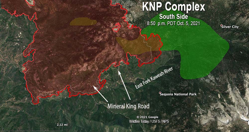
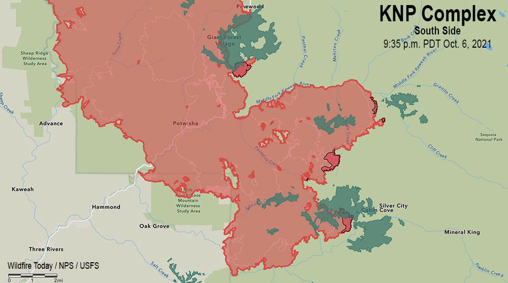
On the south zone, heavy equipment and crews are implementing structure protection actions around Case Mountain Grove, Silver City, and Mineral King. Fire spread south of Mineral King Road is being reduced with line construction and hose lays in place.

Evacuation ORDERS and WARNINGS are still in place.

Fire crosses Generals Highway on the KNP Complex of Fires
Fire crosses Generals Highway on the KNP Complex of Fires. Posted Oct. 6, 2021. InciWeb.

A study evaluated the cultural safety of indigenous wildland firefighters in Canada

From a recently completed study in Canada:


Funded by Natural Resources Canada, a project provided preliminary data on cultural safety and occupational health and safety that is necessary to improve the understanding of Indigenous perspectives on wildland firefighting and wildland fire operations across what is now called Canada.

Wildland firefighting is a unique occupation. For decades, Indigenous (First Nations, Métis, and Inuit) firefighters and fire operations staff have been engaged in wildland fire suppression activities, formally and informally. They are increasingly being called upon by their communities and the broader wildfire management agency community in Canada to engage and deploy in various wildfire suppression and related duties. In the past decade, we have seen an increase in wildfire activity and the number of communities put at risk or impacted by high-intensity wildfire events. Due to the nature of this work, Indigenous Peoples engaged in wildland fire suppression activities routinely work in hazardous situations and stressful environments – impacting their physical, mental, and spiritual/cultural well-being.

Giving Voice to Cultural Safety of Indigenous Wildland Firefighters in Canada was a multidisciplinary, collaborative team-based project.

From January – July 2021, the Turtle Island Consulting Services Inc. (TICS Inc.) Project Team explored the following set of questions:

  • What are Indigenous wildland firefighters’ and wildland fire operations staff’s experiences regarding accident/injury rates, sickness presenteeism/absenteeism, chronic illness, close calls, racism/ discrimination/harassment?
  • What is currently working on the fireline and fire operation centres to promote cultural safety of Indigenous wildland firefighting personnel?
  • What are the priority needs/issues and recommendations for enhancing cultural safety for Indigenous wildland firefighting personnel?

The TICS Inc. Project Team developed an online survey and virtual circles were conducted specifically for individuals who self-identified as Indigenous and worked in wildland firefighting and/or fire operations for at least one fire season in Canada. These participant selection criteria supported the sharing of Indigenous Peoples’ voices in culturally safe spaces to help (i) increase the understanding of their jobs, (ii) enhance overall satisfaction from a cross-cultural perspective during this important work, and (iii) aid in making the future of wildland firefighting more enjoyable, safer, and culturally inviting.

For more information about Project findings, please view the following reports.


The Executive Summary is immediately below. Farther down you can click to download it or view it online .

[pdf-embedder url=”https://wildfiretoday.com/wp-content/uploads/2021/10/Summary-Giving-Voice-to-Cultural-Safety-of-Indigenous-Wildland-updated-Oct-2021.pdf” title=”Giving Voice to Cultural Safety of Indigenous Wildland Firefighters in Canada”]

Thanks and a tip of the hat go out to Marty.

Smoke from California wildfires increases doctor visits and blocks sun from crops

Study shows N95 masks can reduce hospital visits for smoke inhalation by up to 40 percent

Smoke on the Monument Fire
Smoke on the Monument Fire, Sept. 18, 2021. Photo by NRIMT2-FBAN.

Recent articles on MSN.com pointed out three different wildfire smoke related issues.

Smoke in California’s Central Valley increased doctor visits (Oct. 3 2021)

Dr. Praveen Buddiga, a local allergy and immunology specialist, says he saw an increase in patient visits on Friday due to the smoke sitting in the Valley.

“Today I’ve been seeing a lot of patients with cough, congestion, difficulty breathing and this is directly related to the air,” said Dr. Buddiga.

Dr. Buddiga said many of his patients have difficulty breathing, which is not surprising considering the smoke is even visible in satellite images taken from space.

Some masks can protect against wildfire smoke (Sept. 30, 2021)

Researchers found that N95 masks often used for protection from COVID-19, are effective in reducing the inhalation of wildfire smoke particles, and could reduce hospital visits for wildfire smoke inhalation by up to 40 percent. They found that surgical masks, primarily designed to keep sneeze and cough droplets from emerging in the air, do not not protect the wearer against a dangerous environment. Cloth masks used alone are also ineffective. While surgical masks by themselves were ineffective, combining them with a cloth mask to compensate for the surgical mask’s loose fit was about as effective as an N95 as long as the seal around mouth and nose was good.

Wildfire smoke is blocking Central Valley crops from the sun (Oct. 6, 2021)

…This smoke could cause some damage to the raisin and almond crops that are still drying out in the fields.

“Those two crops specifically need mother nature, as in the sun, to dry those crops out in the field, and that drying time is essentially eliminated right now with the smoke layer that we have,” said Ryan Jacobsen, CEO of the Fresno County Farm Bureau, “We’re just not seeing it, we aren’t seeing any drying taking place and that becomes very problematic especially for raisins because if they don’t dry they’re going to sit there and rot in the field. So, we’re hoping that this weather change we’re going to see take place in the next couple of days hopefully blows this smoke out of there and returns the sun to help us finish off this crop year.”

Jacobsen says the Farm Bureau’s other priority is the health and safety of farmworkers. For their protection, the bureau has been providing N95 respirators to agricultural employers.

Thanks and a tip of the hat go out to Jim.

USFS approves new fire retardant product to be applied from the ground

PHOS-CHEK FORTIFY
PHOS-CHEK FORTIFY being applied from an ATV. Perimeter Solutions photo.

The US Forest Service has given approval to a new formulation of fire retardant specifically designed to be applied from the ground. Perimeter Solutions, the maker of PHOS-CHEK long term fire retardant, has added PHOS-CHEK FORTIFY to its inventory of products, saying that “it is the only highly-durable fire retardant that has been approved by USDA Forest Service for preventative application on U.S. federal lands.”

FORTIFY is based on a hydrogel platform and polymer technology to provide enhanced durability to weathering as well as adherence to vegetation. It can be applied on flammable vegetation and cellulosic material early in the fire season before a wildfire approaches and provides ongoing protection, remaining effective until a significant rain event of one inch or more. Unlike retardant dropped from aircraft, which is colored to help pilots track where the retardant is dropped during active wildfires, the durable FORTIFY fire retardant is uncolored and is precision applied from the ground.

Perimeter Solutions says the product was developed in 2018 and over the past three years utilities, railroads, insurance companies, homeowners, and other industries have adopted it as a solution to prevent wildfire ignitions and proactively protect their property from wildfires.

PHOS-CHEK FORTIFY
PHOS-CHEK FORTIFY being applied from a water tender. Perimeter Solutions photo.

Firefighters on the KNP Complex of fires working to contain slop overs across Generals Highway

The fire in Sequoia National Park has burned more than 81,000 acres in California

8:03 a.m. PDT Oct. 6, 2021

KNP Complex of fires, near Eshom
KNP Complex of fires, near Eshom Campground, Oct. 4, 2021. InciWeb.

On the KNP Complex of fires in Sequoia National Park in Southern California, the smoke, which has limited the use of firefighting aircraft for days or weeks, cleared by mid-morning Tuesday more than it had in recent days which allowed the use of some aviation resources both on the north and south ends of the fire. An increase in relative humidity has slowed the spread for the last two days, allowing firefighters to construct direct fire line near the fire’s edge where conditions permit.

The blaze was mapped Tuesday evening at 81,473 acres, an increase of more than 20,000 acres in the previous 48 hours.

KNP Complex map, 8:50 p.m. Oct. 5, 2021. The white line was the perimeter on the evening of Oct. 4. The green areas are the APPROXIMATE locations of groves of giant sequoia trees.

Approximately 550 acres have burned north of Generals Highway one mile southeast of the community of Wilsonia. Tuesday evening Operations Section Chief Chad Rice said hand crews and dozers are constructing line around that large slop over, tying in to old fire lines, fuel treatments, and roads where they exist. That should be complete “in a few shifts,” Mr. Rice said.

A large number of firefighters are working in Grant Grove and Wilsonia to make them easier to defend if the fire spreads into those areas.

KNP Complex map, north side
KNP Complex map, north side, 8:50 p.m. Oct. 5, 2021. The white line was the perimeter on the evening of Oct. 4. The green areas are the APPROXIMATE locations of groves of giant sequoia trees.

The incident management team has not released information about the mortality of the giant sequoias in the Redwood Mountain Grove after the fire spread rapidly through the area on October 4. It is the largest grove on Earth of the trees and contains the world’s tallest giant sequoia, 312 feet (95 meters). The huge trees with bark up to a foot thick are normally fire resistant and can live for more than 3,000 years old if climate change was not creating multi-year droughts and extremely low fuel moistures. Last year the Castle Fire, just to the south, destroyed an estimated 7,500 to 10,600 large sequoias with trunk diameters of more than four feet, which was 10 to 14 percent of all large sequoias across the tree’s natural range in the Sierra Nevada.

Near Stony Creek Lodge and Cabin Creek on the northeast side of the fire there is a 200-acre slop over across Generals Highway that firefighters are working on.

On the south side, the fire has crossed Mineral King Road in several places, which in that steep topography raises the level of difficulty in stopping the spread in that area. It has not yet crossed the East Fork of the Kaweah River, but Operations Section Chief Chad Rice said he expects it will cross to the south side. The terrain, fuels, fire behavior, and the one-lane road so far have made it unsafe for fire crews to work in some locations on the south edge of the fire, Mr. Rice said. For several hours on Tuesday a boulder the size of a car rolled down onto the road, blocking it until the boulder could be removed.

KNP Complex map, south side
KNP Complex map, south side, 8:50 p.m. Oct. 5, 2021. The white line was the perimeter on the evening of Oct. 4. The green areas are the APPROXIMATE locations of groves of giant sequoia trees.

There are no reports of any residences being destroyed. Resources assigned to the fire include 38 hand crews, 111 fire engines, and 16 helicopters for a total of 1,866 personnel.

Evacuation details are available on a map and at the  Tulare County Sheriff’s Facebook Page.

Lightning started two fires on September 9, the Paradise and Colony Fires, which later merged to become the KNP Complex of fires. It is burning in the Sequoia and Kings Canyon National Park and Sequoia National Forest and is being managed as a full suppression fire.

Harry R. “Punky” McClellan, 1940 – 2021

A leader in fire prevention

Punky McClellan passed away on September 27, 2021 in Ojai California.  He had retired from the Sierra National Forest some 30 years ago. He began his FS career on the Los Padres National Forest working on an Engine and as a patrolman on the Ojai and San Marcos Ranger Districts.  He transferred to the Sequoia National Forest Hume Lake RD as the Fire Management Officer and then to the Sierra National Forest as the Assistant Forest Fire Management Officer.

Punky worked on many national level fire management assignments including the Safety First Program in the early 1970s which led to such things as minimum engine staffing, training and qualifications standards, firefighter safety equipment such as Nomex and fire shelters, etc. The project ultimately led to Congress assigning the Forest Service with the development of the ICS system for all California fire agencies and eventually to national implementation.

While on the Sierra Punky was funded and assigned a national office position to manage the National Fire Prevention Program.  He developed and distributed program materials for the Wildfire Strikes Home Initiative, developed training and guidelines for Fire Prevention Planning, and probably most memorable was the development of high visibility fire prevention education programs with professional sports teams and celebrities.  Radio and television public service announcements using the celebrities and athletes were produced and thousands of fire prevention education materials were developed and distributed. In 1987 he organized a National Smokey Bear Day Event at every Major League baseball stadium.

After retirement Punky continued with his passion for fire management through his company THE FIREHOUSE.  Working with NFPA and local jurisdictions he developed an urban fire safety program and set of characters called the Preventor Program and developed a wildland set of characters for the Fire Education Team Program managed by the Department of Interior. He managed the training and mobilization of National Interagency Fire Prevention Teams.  He authored several books including “REMEMBER ONLY YOU” – A History of Outdoor Forest Fire Prevention Advertising and THE FRONT LINE – A Look at Some of America’s Historic Firehouses.  He was active internationally with work in Russia, Mexico and Canada.

Punky is the only person to have received all three National Fire Prevention Awards – Bronze, Silver and Golden Smokeys.  He was a recipient of the Secretary of Agriculture’s Superior Service Award, as well.

Plans are underway to build a memorial statue and scholarship fund on Punky’s behalf.  A Gofund Me account is being established but in the interim donations toward that effort can be forwarded to Riley McClellan at 2660 Alamos Avenue Clovis, CA  93611.

Danny Jones
Three Forests Interpretive Assn.
30330 Watts Valley Rd
Tollhouse, CA   93667
(559) 855-8419