A 911 caller said the suspect was attempting to steal a helicopter
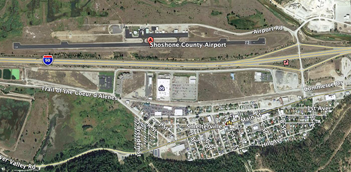
Map, Shoshone County Airport. Wildfire Today / Google Earth.
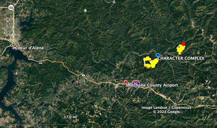
On Saturday July 17, wildland firefighters at the Shoshone County Airport in Smelterville, Idaho 30 miles southeast of Coeur d’Alene, encountered a dangerous situation that is not covered in the dozens of training courses they take.
From the Shoshone County Sheriff’s Office:
At approximately 5:52pm, Shoshone County Sheriff’s Office (SCSO) dispatch received a 911 call reporting an armed subject approaching fire personnel in their helicopter at the Shoshone County Airport in Smelterville Idaho. A second 911 caller reported the subject was attempting to steal a helicopter.
At the airport during this incident, there were between 30 to 70 fire fighter personnel present on scene due to the local active fires.
At approximately 5:57pm, a SCSO Deputy arrived on scene and quickly located the armed suspect (Oregon resident). The suspect then discharged a handgun several times into the ground and air as fire fighter personnel were fleeing the immediate area. The SCSO Deputy ordered the suspect to drop the weapon, he complied soon after and was taken into custody with the assistance of a 2nd SCSO Deputy and an Idaho State Police Trooper without further incident. Several other SCSO units and other law enforcement agencies arrived shortly after.
For clarification, NO law enforcement officers discharged a firearm and no one was injured during this incident.
The investigation is ongoing and no further information will be released at this time.
End of Shoshone County Sheriff’s Office report.
In the video below, the narrator says he’s at the Kellogg, Idaho airport. Kellogg is immediately east of Smelterville.
Vicinity map, Shoshone County Airport. Google Earth.
There are at least five large significant wildfires currently burning in Washington and Oregon. Here is a quick and dirty summary. The acreages were as of Saturday evening, but all were putting up large smoke plumes Sunday easily seen from a satellite.
Working north to south, starting in Washington:
Cub Creek 2 Fire
4,690 acres, 5 miles north of Winthrop, Washington. Numerous residences are threatened. Evacuations are in effect, including for pack animals, mules from the Okanogan-Wenatchee National Forest who were relocated to their winter pasture.
pack mules on the Oka-Wen
The north flank of the Cub Creek 2 remains unchecked. Retardant from very large air tankers, water scooping planes, and helicopters with buckets are providing support to firefighters in all locations of the fire. It is burning north pushed by diurnal winds during the day and smoke pushed down south during the late evening and morning.
Cedar Creek Fire
4,080 acres, 12 air miles northwest of Winthrop, Washington, very close to Highway 20. The western perimeter of the fire has burned onto a ridgeline with sparse fuels, slowing the spread. On the southern portion of the fire, growth has been minimal as it burns in subalpine areas with minimal vegetation. The northeastern portion remains the most active.
Summit Trail Fire
2,031 acres, 17 miles west of Inchelium. It has only been burning for three days. On Saturday crews continued to build direct fire line. There was fire growth on the north-northwest side of the fire, and crews scouted Upper Ridge Creek Road, developing a plan to prep and hold the fire along the road.
Due to limited resources the fire continued to spread Saturday to the northeast at a moderate rate of spread, but that pace increased Sunday.
And in Oregon:
Jack Fire
16,764 acres, on both sides of Highway 138, 9 miles northwest of Clearwater. South of Highway 138, firefighters continue burnout operations to build primary line on the west and southwest flanks. On the southeast side, crews will continue to use heavy machinery to clear and brush out roads used as control lines.
Bootleg Fire
298,662 acres, 30 miles northeast of Klamath Falls. The Bootleg Fire continued to push further into Lake County for a distance of five miles on the north side and ten on the east side. It remains about four to five miles north of Highway 140. It was extremely active again on Sunday, as can be seen in the satellite photo above.
In Southern Oregon, 30 miles northeast of Klamath Falls
1:51 p.m. PDT July 18, 2021
Map of the Bootleg Fire. The white line was the perimeter at the end of the day on July 17. The yellow line was the perimeter about 48 hours before. (A technical glitch caused them to be offset a little.) The red areas represent heat detected by a satellite at 4:12 a.m. PDT July 18, 2021.
The Bootleg Fire in Southern Oregon which is primarily in Klamath County continues to push further into Lake County for a distance of five miles on the north side and ten on the east side. It remains about four to five miles north of Highway 140.
The additional growth on Saturday brought the size up to more than 298,000 acres.
(To see all articles on Wildfire Today about the Bootleg Fire, including the most recent, click HERE.)
Hot, dry, and windy weather conditions played a significant role in fire behavior Saturday. The fire crossed Sam’s Cabin Road and the 27 Road to the north. It is held from Preacher Flats to Mitchell Monument and is pushing further east, approaching the 28 road. Firefighters were able to construct dozer line and execute a burnout to minimize the fire growth overnight. One of Sunday’s priorities will be to attempt hold these areas to prevent further spread.
Firefighter on the Bootleg Fire. Photo by PIO J. Michael Johnson. InciWeb July 17, 2021.
Other priorities include constructing direct fireline and building contingency lines north of the fire in the Sycan Marsh and along the 28 Road to the south. These contingency lines may be used if the fire continues to march towards the communities of Paisley, Summer Lake, and Silver Lake.
Feller Buncher and its Operator, July 17, 2021. InciWeb.
The weather forecast for Sunday in the Beatty, Oregon area calls for 91 degrees, 8 percent relative humidity, and 11 to 17 mph winds gusting out of the southwest at 26 mph for a couple of hours in the late afternoon. Monday the conditions will be similar, but with a much more serious wind component. For about 11 hours the wind will be from the southwest at 13 mph gusting at 20 mph, and changing directions three times — at dawn, 11 a.m., and 10 p.m.
Early photo of the Bootleg Fire, around July 6, 2021. InciWeb.
The fire has burned about 23,000 acres near Woodfords and Markleeville in Northern California
Updated 10:38 a.m. PDT July 19, 2021
Tamarack Fire map. The white line was the estimated perimeter Sunday afternoon, July 18. The yellow line was the perimeter at 6:30 p.m. PDT July 17. The red dots represent heat detected by a satellite at 3:06 a.m. PDT July 19, 2012.
The Incident Management Team said Monday morning the approximate size of the Tamarack Fire near Markleeville, California is 23,078 acres.
The weather over the fire was not extreme Sunday and Sunday night, but the fire remained active into the night in spite of the relative humidity rising into the 40s after 5 p.m. Clouds in the afternoon and during the night prevented a mapping flight after sunset. The aircraft uses infrared technology that can “see” through smoke, but not clouds.
The perimeters on the eastern side of the fire on these maps is an estimate.
To see all articles on Wildfire Today about the Tamarack Fire, including the most recent, click HERE.
During a satellite overflight Monday at 3:06 a.m. a hole in the clouds permitted it to sense a great deal of heat on the northeast section of the fire in a surprising location, but some other areas on the fire may have been blocked by clouds. This satellite data should be considered unverified until it can be ground truthed or confirmed with a mapping flight. The wind direction overnight was quite variable, perhaps affected by passing thunderstorms, and could be the explanation for spread directions not previously seen.
It appears, from the incomplete information about the fire’s perimeter, that a portion of the northeast side of the Tamarack Fire has bumped into the East Fork Fire which burned just a couple of weeks ago. (see the map above)
The Incident Meteorologist assigned to the fire reported rain reaching the ground late in the afternoon Sunday, and the Hawkins Peak camera showed raindrops on the lens. We checked several weather stations around the fire and could not find any that recorded precipitation. A very small amount of rain in isolated locations will not have any significant long term effect.
Tamarack Fire map. Estimated perimeter at 3 p.m. PDT July 18, 2021.
The map above shows completed fire line around much of Markleeville — the black line in the center of the fire. It was constructed by dozers and hand crews who later burned out from the lines, robbing the fire of fuel as it approached. It is likely that these efforts by firefighters prevented some structures from being consumed.
In spite of their efforts, the National Situation Report indicates that 10 structures have been destroyed. A damage assessment team has been ordered and will determine exactly how many structures have been destroyed or damaged.
Firefighters are working to limit fire spread north towards Highway 88 and Carson Canyon. Monday, as resources become available, they will begin line construction at Highway 89 moving to the southwest.
Residents can sign up for evacuation notifications by clicking on a link at https://alpinecountyca.gov/204/Sheriff. However, we checked it again at 8:25 a.m. Monday and the site was still down.
The Incident Management Team reported Monday morning the following areas “are under evacuation:” Markleeville, Grover Hot Springs and campground area, Shay Creek, Marklee Village, Alpine Village, Woodfords, East Fork Resort, and the community of Hung A Lel Ti.
There is a 60 percent chance of wetting rain Monday in the fire area, with a possibility of flooding in drainages, and debris flows on steep terrain.
Resources assigned to the fire Sunday evening included 18 hand crews, 62 engines, and 6 helicopters for a total of 796 personnel.
A Type 1 Incident Management Team, Rocky Mountain Team 1 (Incident Commander – Dallas), will be in-briefed Monday and will assume command from Great Basin Team 3 (IC-Bollier) Tuesday.
9:26 a.m. PDT July, 18, 2021
Map of the Tamarack Fire. The yellow line was the approximate perimeter at 3:42 a.m. PDT July 17, 2021. The white line was the perimeter at 6:30 p.m. PDT July 17. The red dots represent heat detected by a satellite at 3:24 a.m. PDT July 18.
The Tamarack Fire in Northern California crossed Highway 89 Saturday, burning past Markleeville prompting additional evacuations of Woodfords and Alpine Village. The fire crossed the East Fork of the Carson River near the East Fork Resort and moved into lighter fuels which aided in the growth to the north and northeast during the afternoon hours, spreading approximately three to five miles in 24 hours.
Saturday at 5 p.m. the Incident Management Team reported that the fire had burned an estimated 21,000 acres, and that mandatory evacuations were in place for the following areas: Grover Hot Springs, Shay Creek, Marklee Village, Markleeville, Carson River Resort, Poor Boy Road area, Wolf Creek Campground, Silver Creek Campground, Sierra Pines, Upper and Lower Manzanita, Crystal Springs, Alpine Village, Diamond Valley Road and Hung-a-lel-ti.
Residents can sign up for evacuation notifications by clicking on a link at https://alpinecountyca.gov/204/Sheriff. However, we checked it at 8:50 a.m. Sunday and the site was down.
The number of reported structures destroyed remains at two. The fire continues to impact Markleeville and the surrounding areas. Firefighters are actively suppressing the fire where they can safely do so utilizing a variety of tactics and natural barriers.
In the photo below taken at 9:15 a.m. Sunday, the Tamarack Fire appears to already be creating pyrocumulus clouds. This is not common a few hours after sunrise.
Dan Steffensen. Photo courtesy of Red Lodge Fire Rescue.
Red Lodge Fire Rescue has released information about a firefighter who suffered serious burns while battling the Harris Fire near Joliet, Montana 25 miles northeast of Red Lodge, MT on July 16. Dan Steffensen was on a two-person engine crew when strong winds suddenly shifted in his direction. He attempted to reach safety, but was overrun by the fast moving fire and injured. Due to the severity of his burns, Mr. Steffensen was admitted to the University of Utah Burn Center in Salt Lake City in serious condition. His family and firefighting colleagues are traveling to be with him.
The other person on the engine was Scott Wilson, who was not injured. He acted quickly to make the notifications and assist in getting emergency medical care for his partner.
From Red Lodge Fire Rescue:
Dan has been a firefighter with Red Lodge Fire since 2015. In 2017 Dan was selected as volunteer “Firefighter of the Year” and works on the fuel mitigation/Initial Attack crew where in the summers he works to reduce hazardous fuels around homes and responds to emerging wildland fires. He is a nationally qualified wildland firefighter and has fought fires in Montana, Oregon, California and other western states as an engine boss and water tender operator.
Those wanting to help support Mr. Steffensen and his family can donate via the GoFundMe page which has been set up for his benefit.
L to R, Dan Steffensen and Scott Wilson. Photo courtesy of Red Lodge Fire Rescue.
If you’re thinking the town of Red Lodge, Montana sounds familiar, the Robertson Draw Fire just south of the community burned over 27,000 acres in June.
Evacuations are in effect and structures have burned south of Woodfords, California
Updated at 5:03 p.m. PDT July 17, 2021
Tamarack Fire map, showing heat detected by a satellite as late as 2:12 p.m. PDT July 17, 2021.
We have a new map for the Tamarack Fire showing data from a satellite overflight at 2:12 p.m. PDT July 17.
To see all articles on Wildfire Today about the Tamarack Fire, including the most recent, click HERE.
Updated at 3:48 p.m. PDT July 17, 2021
Tamarack Fire as seen from the North Moc camera looking northeast at 3:05 p.m. July 17, 2021.
The Tamarack Fire, like many of the other recent wildfires in California and Oregon is cranking Saturday afternoon. Photographer Craig Philpott has video of it moving east at a rapid rate of spread across Highway 89 north of Markleeville, south of Airport Road .
An update from Alpine County at 3:13 p.m. Saturday said 7,000 acres have burned and 2 structures were destroyed. Aerial firefighting is limited by dense smoke. Also:
Mandatory evacuations are in place for the following areas: Grover Hot Springs, Shay Creek, MarkleeVillage, Markleeville, Carson River Resort, & Poor Boy Road area, Wolf Creek Campground, Silver Creek Campground, ADDITIONALLY Sierra Pines, Upper and Lower Manzanita, Crystal Springs, Alpine Village, Diamond Valley Road and Hung-a-lel-ti are now under mandatory evacuations. “The Mesa” is under a voluntary evacuation but conditions are changing fast. Please stay out of these areas to allow emergency personnel to do their jobs.
It is my understanding that this time of year in this part of California fires are often pushed to the northeast. Out ahead of the Tamarack Fire in that direction there is not much recent history of fires. Under the present conditions of dry fuels, high temperatures, and low humidity, those 30+ year old fire footprints from the 1980s are not likely to provide much of a barrier.
Fire history, Tamarack Fire area.
The image below shows the track of an Air Attack aircraft which supervises other aerial firefighting aircraft and provides real time situational awareness about the fire to personnel on the ground. Presumably the fire, or at least the most dense smoke, is inside the U-shaped flight path.
An at 3:18 p.m. PDT July 17, 2021. FlightRadar24
9:07 a.m. PDT July 17, 2021
Tamarack Fire, showing heat detected by a satellite at 3:42 a.m. PDT July 17, 2021.
The Tamarack Fire spread for about five miles Friday after it had been in a monitoring status for 13 days while it was very small. It moved northeast and according to heat sensing data from satellites very early Saturday morning appeared to have come very close to the community of Markleeville and Highway 89.
The Alpine County Sheriff’s Office reported at about 8 a.m. Saturday that the fire was 6,600 acres, three structures had burned, and, “This is a serious situation. Please get out when advised to.” They also advised to not rely on Facebook for evacuation notifications.
The Humboldt-Toiyabe National Forest updated InciWeb at 8 a.m. Saturday:
Highway 89, 88 and 4 are closed in the fire area. Evacuations are in place for Markleeville, Grover’s Hot Springs Park and Campground, Shay Creek, Markleeville Village and East Fork Resort. Residents can sign up for evacuation notifications at https://alpinecountyca.gov/204/Sheriff. Evacuees can report to Alpine County School in Paynesville.
According to satellite data at 3:42 a.m. PDT July 17, 2021, the fire was very close to Markleeville, 5 miles south of Woodfords, and 18 miles south of South Lake Tahoe.
Tamarack Fire as seen from Hawkins Peak, looking southeast at 8:38 a.m. PDT July 17, 2021.
Below is a still image of a Forest Service Facebook post with a video of the fire when it was a quarter acre on July 10, six days after it started. “Fire poses no threat to the public, infrastructure, or resource values,” they wrote.
The satellite photo below taken at 6:41 p.m. PDT July 16 shows a large smoke plume created by the Tamarack Fire.