Map of the Dry Gulch Fire and Snake River Complex of fires. The red areas represent heat detected by a satellite at 2:54 a.m. MDT July 12, 2021.
Wildfires are still very active where three states meet, Washington, Oregon, and Idaho.
Dry Gulch
Nearly all of the spread of the fire over the last two days has been on the southwest side. A mapping flight Sunday night found that it had grown to 55,050 acres, but has moved no closer to Lewiston, Idaho and is still 10 miles southwest of the city. The Dry Gulch Fire merged with the Lick Creek Fire on July 8 and they are now treated as one — Dry Gulch.
On Sunday evacuation warnings ( Level 2, get set) were in effect, but no actual evacuation orders (Level 3, leave now). (Very Brief Editorial: We need a national system of evacuation criteria that is uniform across the country, makes sense, and does not require training or explanation!)
Dry Gulch Fire, July 9, 2021. InciWeb photo
The Dry Gulch Fire has been managed by a Type 2 Incident Management Team, but a Type 1 Team will assume command Monday, July 12.
Resources assigned on Sunday evening included 14 hand crews, no helicopters, 52 fire engines, and 4 dozers for a total of 536 personnel.
Snake River Complex
The 54,407-acre fire 12 miles south of Lewiston, Idaho is being managed by a Type 2 Incident Management Team. It is comprised of three fires that burned together, Shovel Creek, Captain John Creek, and Hoover Ridge. The growth over the last two days has been closer to each other as well as to the east and the south. It is bordered on the west side by the Snake River. The greatest spread Sunday was on the south side where the Shovel Creek Fire came close to the Salmon River. The east side of the Hoover Ridge Fire is being held by the Salmon River.
Approximately 438 residences are threatened.
From the Incident Management Team Sunday evening:
On the north end of the fire, resources continue to protect values at risk including primary structures and infrastructure around Waha Lake and Red Bird road. Tactics include a combination of indirect line followed up with burning in Madden Creek and around to the south. In the Craig Mountain area, resources are completing indirect fireline to the north. The Hoover Ridge fire resources continue to secure the northeast corner down to the Salmon River. Resources are still using a point protection strategy to burn around and secure values at risk in both the Salmon and Snake Rivers.
Resources assigned Sunday evening included 3 hand crews, no helicopters, and 6 fire engines for a total of 170 personnel.
Dixie Fire
The 15,323-acre Dixie Fire just east of Dixie, Idaho is not being completely suppressed by the Nez Perce-Clearwater National Forest. It is being managed by a Type 1 Incident Management Team. Resources that are 15% monitoring, 30% confining, 35% point protecting, and 20% suppressing the fire include 8 hand crews, 16 fire engines, and 4 helicopters for a total of 522 personnel. The same team is managing the nearby 898-acre Jumbo Fire. (map)
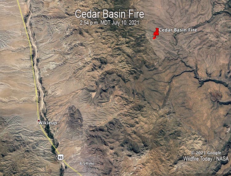
The incident occurred at about noon during initial attack efforts on the Cedar Basin Fire, which is 14 miles east of Wikieup in northwestern Arizona.
Pilot Matthew Miller, 48, and Air Tactical Group Supervisor Jeff Piechura, 62, were on board a Beechcraft King Air C-90 aircraft conducting visual reconnaissance and aviation command and control over the fire. Mr. Miller was a fire pilot with Falcon Executive Aviation, Inc. contracted by the U.S. Forest Service. Mr. Piechura was an employee with the Coronado National Forest. Their remains have been recovered from the accident site.
Often eyewitness accounts are wrong.
But, the Arizona Republic interviewed a woman who saw the aircraft from her home coming down at a “steep angle” and then “slam into the ground.” An hour later she and her husband drove to an area near the crash. They said Bureau of Land Management employees told them they they witnessed a wing fall off the plane in the air before it crashed.
We are aware of four other wildland fire related aircraft crashes in North America this year in a 46-day period, for a total of 7 fatalities:
A helicopter went into Lake Shastina July 7 while working on the Lava Fire in Northern California. The pilot swam away.
Four were killed in the May 25 crash of a helicopter at Leesburg, Florida.
In 2020 during a 49-day period that began July 7 there were six crashes of firefighting aircraft — three helicopters and three air tankers. In addition, three members of the crew of a C-130 from the U.S. died when their air tanker crashed January 23, 2020 while fighting a bushfire in New South Wales, Australia.
The article was edited to show that there were no reported serious injuries in the June 15 helicopter crash.
By Sunday night it had burned more than 153,000 acres
Updated at 8:10 p.m. PDT July 12, 2021
Bootleg Fire map. The white line was the perimeter at 9:16 p.m. PDT July 11, 2021. The red areas represent heat detected by a satellite at 2:12 p.m. PDT July 12, 2021.
After three days of explosive growth, a smoke inversion moderated fire activity Sunday on the Bootleg Fire and allowed fire crews to construct and improve fire control lines. However that changed on Monday. By 2 p.m. a strong west wind had pushed the fire one to four miles further east, and it continued that direction into the late afternoon. (see the map above)
Due to the size and complexity the fire will be managed using two zones. This will allow the two primary incident management teams to better manage the fire and limit travel for firefighters. ODF Incident Management Team 1 assumed command of the fire’s south part, or Zone 1, Monday. Pacific Northwest Team 10 manages the north part, or Zone 2. The Oregon Office of State Fire Marshal’s Green Team continues to protect structures.
(To see all articles on Wildfire Today about the Bootleg Fire, including the most recent, click HERE.)
Part of the fire has burned across a major interstate power line, a corridor of three parallel 500 kV lines that connect to power grids in Oregon and California. But the northeast part of the fire was still burning intensely Monday afternoon near the lines. Since there was concern with the lines having been de-energized combined with very high temperatures requiring more air conditioning in homes, a statewide FlexAlert was issued in California for Monday from 4-9 p.m. This meant there was a possibility of power shutoffs due to an inadequate supply of electricity.
Evacuations Level 3 (GO NOW) in effect at 3 p.m. PDT July 12, 2021:
Klamath County, north of the town of Beatty. East side of Godowa Springs Road north of the OC and E Trail to the Klamath County Line.
Klamath County, near the town of Sprague River. Upper tableland area north of Oregon Pines Rd need to leave immediately.
If you look closely at the smoke from the Bootleg Fire in the satellite image below, you may notice that the white pyrocumulus cloud above the smoke plume rose to such a high elevation that it cast a shadow as the sun got low in the sky at 7:01 p.m. local time.
Satellite photo, wildfires in the West, at 7:01 p.m. PDT July 12, 2021. NASA.
Updated at 2:20 p.m. PDT July 11, 2021
Map of the Bootleg Fire at 11 p.m. PDT July 10, 2021.
Saturday the Bootleg fire in Southern Oregon grew to Megafire status, crushing the 100,000-acre threshold. After advancing for four miles to both the east and north it was mapped Saturday night at 143,607 acres, an increase of more than 53,000 acres in about 24 hours.
It is now 4 miles north of Beatty and Highway 140, 27 miles northeast of Klamath Falls, and 20 miles east of Chiloquin.
On Saturday, firefighters, emergency managers, and other public safety officials faced the fifth day in a row of extreme, intense fire behavior as hot, dry, windy weather persisted.
Those conditions escalated Saturday afternoon, resulting in an immediate, life-threatening risk to area residents, visitors, firefighters and other emergency responders.
Due to public safety concerns and the immediate threat to life, the Klamath County Sheriff’s Office took the rare step of citing or arresting those who remained in or were trying to re-enter the Level 3 (leave now) evacuation areas.
Conditions were so extreme Saturday that firefighters needed to disengage and move to predetermined safety zones. Fire managers evaluated conditions and looked for opportunities to reengage firefighters safely.
Wildland and structure protection Incident Commanders Al Lawson and Lance Lightly stated “Our first priority is to provide for firefighter and public safety. Removing our personnel from these conditions is always our guidance under such extreme conditions.”
“Today marks the 20th anniversary of the Thirtymile Fire, where four firefighters tragically lost their lives,” said Lawson. “The fire behavior we are seeing on the Bootleg Fire is among the most extreme you can find and firefighters are seeing conditions they have never seen before. We understand the frustration of the community as the fire continues to grow. We also need to ensure our firefighters are able to engage safely so that they can return home at the end of this assignment to their families.”
The fire has burned across a major interstate power line. It is actually a corridor of three parallel 500 kV lines that connect to power grids in Oregon and California. (see map above)
“The fire was moving in and through the powerlines,” said Gayne Sears, a public information officer with the Bootleg Fire, told Oregon Public Broadcasting Saturday afternoon. “The companies made decisions, or there was enough fire and smoke that the lines did go down some, but they’ve been working very carefully with the firefighters to re-energize in safe manners.”
Sears said she didn’t know whether they were currently online. (More information about this critical power line and the fire.)
Saturday evening the 143,607-acre fire was being managed by a Type 2 Incident Management Team and an Oregon State Fire Marshal team that was assisting with structure protection, but on Sunday two Type 1 Incident Management Teams were mobilizing.
Resources assigned Sunday include 19 hand crews, 10 helicopters 6 dozers, 83 fire engines, and 25 water tenders for a total of 926 personnel.
The fire area is under a heat advisory through Tuesday. The weather forecast for Beatty, Oregon on Sunday calls for a high of 85 degrees, 8 to 10 mph winds out of the west, and a relative humidity of 11 percent. On Monday the prediction is for 94 degrees, northwest winds gusting to 20 mph, and 10 percent RH.
Satellite photo showing smoke from wildfires at 8:26 a.m. PDT July 10, 2021.
The Sugar Fire grew by more than 25,000 acres Saturday
8:31 a.m. PDT July 11, 2021
Map of the Sugar Fire, part of the Beckwourth Complex. The white line was the perimeter at 2:03 a.m. PDT July 11, 2021. The yellow line was the perimeter approximately 24 hours before. The red dots represent heat detected by a satellite at 2:18 a.m. PDT July 11, 2021.
The Sugar Fire, the only active fire in the Beckwourth Complex, ran to the east and northeast Saturday, crossing US Highway 395 in at least two places destroying structures in Doyle, California.
Videos shot by Craig Philpott showed multiple structures burning in the small town.
The fire spread northeast for about three miles in 24 hours, growing to more than 82,000 acres.
(To see all articles on Wildfire Today about the Sugar Fire and the Beckwourth Complex, including the most recent, click HERE.)
In a virtual community meeting Saturday night, Incident Commander Rocky Opliger said, “We’re looking at unprecedented early season extreme fire behavior…much earlier than we’ve experienced before.”
Highway 395 was closed at times Saturday north of Highway 70.
The National Weather Service has issued an Excessive Heat Warning for the area through Tuesday. The weather forecast for Doyle, CA Sunday afternoon calls for 104 degrees, strong winds out of the southwest Sunday of 21 mph gusting at 32 mph, and 9 percent relative humidity. The wind will subside Sunday night but will increase Monday afternoon — 22 mph gusting out of the southwest at 34 mph with 9 percent RH.
These conditions will make it a challenge for firefighters to make much progress in suppressing the fire.
Satellite photo showing smoke from fires in California and Oregon at 6:36 p.m. PDT July 10, 2021. NASA GOES-16.
This article was first published on Fire Aviation.
Two aerial firefighters were killed July 10 in the crash of an air attack aircraft associated with a wildfire in Arizona. It occurred on the Cedar Basin Fire which is 14 miles northeast of Wikieup, Arizona and 43 miles southeast of Kingman, Arizona.
Below is the statement released Saturday night July 10.
“The Bureau of Land Management is currently working with other local, state, and federal agencies to respond to a fatal aircraft accident associated with the Cedar Basin Fire near Wikieup, Arizona. The accident occurred around noon today (July 10) and involved an air attack aircraft performing aerial reconnaissance and command and control over the fire. Two crew members were on board and we are sad to report there were no survivors. We will provide additional information pending next of kin notification. Our hearts go out to the families of our brave wildland firefighters.”
The Cedar Basin Fire, a result of thunderstorms, was reported to dispatch July 9 after 6 p.m. That night it was not possible to get a good visual due to darkness. On July 10 a helicopter performed a reconnaissance and discovered an active fire. Later that night the fire had burned about 300 acres.
We send our sincere condolences to the families, friends, and co-workers of the two firefighters.
Map showing the location of the Cedar Basin Fire at 2:54 p.m. MDT July 10, 2021.