Smokejumper Tim Hart passes away

Tim Hart. USFS photo
Tim Hart. USFS photo.

Tim Hart, the smokejumper critically injured May 24 in a hard landing while parachuting into the Eicks Fire in New Mexico has passed away. Tim had been flown via air ambulance to a hospital in El Paso, Texas where he has been treated for the last 11 days.

The U.S. Forest Service announced the fatality today in an email sent by Laurel Beth McClean, Executive Assistant to FS Chief Vicki Christiansen, on behalf of the Chief.

“I am deeply saddened to share with you that Tim Hart, a smokejumper from the West Yellowstone Smokejumper Base in Montana, passed away last night as a result of injuries he sustained when jumping on the Eiks Fire in New Mexico on May 24.

“Tim grew up in Illinois and lived with his wife in Cody, Wyoming.  During his firefighting career Tim was an Engine Crew Member on the Coconino, Fremont-Winema, and Shoshone National Forests.  He was a Lead Firefighter on the Ashville and Ruby Mountain (with the BLM) Hotshot Crews.  He moved to Grangeville, Idaho as a Rookie Smokejumper in 2016.   In 2019, he transitioned to West Yellowstone and the Custer Gallatin National Forest first as a Squad Leader and then as a Spotter.   His life touched many people across the Forest Service and the wildland fire community.  He will be greatly missed.

“My heart goes out to Tim’s family, friends and colleagues, and I ask all of you to keep them in your thoughts and prayers.  And, please continue to look out for each other.  I draw my strength, every day, from the compassion and dedication each of you exhibit in service to our nation.  During times of great loss, as we and our partners have experienced over the past week, we pause to reflect on the lives we have lost and the void that can never be filled – and we hold on to, and sustain each other.”


Condolences Mailing Address:

c/o Shoshone National Forest
808 Meadow Lane Ave., Cody, WY 82414

Shoshone National Forest will ensure families receive all condolences.

Tim Hart. USFS photo
Tim Hart. USFS photo.

We send out our sincere condolences to Mr. Hart’s family, friends, and co-workers.
Wildfire in Columbia River Gorge forced evacuations and closure of Interstate

Another fire, north of Beatty, OR, has burned more than 600 acres

7:49 a.m. PDT June 3, 2021

map fire in the Columbia River Gorge
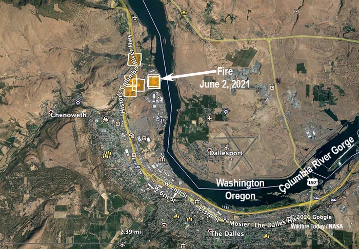
Map showing heat detected on a fire in the Columbia River Gorge June 2, 2021.

A fire in the Columbia River Gorge Wednesday afternoon forced the evacuation of a mobile home park and the temporary closure of Interstate 84 and Highway 30 in northern Oregon.

The fire two miles northwest of The Dalles, Oregon was suppressed by Mid-Columbia Fire and Rescue and the US Forest Service.

Oregon Public Broadcasting reported that the Pine Wood Mobile Manor community, the Columbia River Gorge Discovery Center, and a nearby golf course were evacuated for several hours.

A spokesperson from the USFS said the fire burned about 120 acres.

In 2017 the Eagle Creek Fire burned 48,831 acres in the Columbia River Gorge. Most of the fire was on the Oregon side of the river but a burning ember started a spot fire on the Washington side which was quickly extinguished.  The fire required the extended closure of Interstate 84, forced hundreds to evacuate, and poured smoke into Portland. A judge ordered the teen who started it to pay restitution totaling $36.6 million.

Fire in Columbia River Gorge
Fire in Columbia River Gorge, June 2, 2021. USFS photo.

Another fire 18 miles north of Beatty, Oregon, has burned 679 acres. The Sycan River Fire was being managed by a Type 3 Incident Management Team but the number of personnel assigned has been reduced from 150 to 13.

Firefighters are mopping up the 34-acre Yellow Jacket Fire  4 miles south of Beatty.

Below is a news report on the fire from KOIN 6.

Thanks and a tip of the hat go out to Fred.

NIFC’s forecast for wildfire potential this summer

It is influenced by the fact that more than 87% of the West is now categorized in drought.

Drought year to year

The forecast for wildland fire potential issued June 1 by the National Interagency Fire Center for June through September predicts wildfire potential will be higher than normal in the Southwest until the monsoons arrive in July. For the rest of the period, fire potential will be increasing in the Great Basin and the Pacific Coast states. From July through September nearly all of the mountainous areas of California, Oregon, and Washington are in the above normal category.

NIFC has modified their prediction for the Northern Rockies to show higher than normal fire potential in August for Idaho, Montana,  and most of Wyoming.

The entire eastern half of the U.S. is not expected to have any areas with above normal potential through September.

The data from NIFC shown here represents the cumulative forecasts of the ten Geographic Area Predictive Services Units and the National Predictive Services Unit.

Below:

  • An excerpt from the NIFC narrative report for the next several months;
  • NIFC’s monthly graphical outlooks;
  • NOAA’s three-month temperature and precipitation forecasts;
  • Drought Monitor;
  • Keetch-Byram Drought Index.

    “The year-to-date acres burned remains well below the 10-year average and significant fire activity was also limited during May. The absence of critical fire weather patterns in areas with very dry fuels helped limit significant fire activity in May. Fuels remain very dry across large swaths of the Southwest, Great Basin, and California with fuel dryness in much of the West two to four weeks ahead of schedule.

“Drought expanded and intensified over the West, especially in California. More than 87% of the West is now categorized in drought and over half the West in the highest two categories of drought. Snowpack set new record lows in parts of the West, including the Sierra, in May.

“Climate outlooks indicate warmer and drier than normal conditions are likely for much of the High Plains and West through summer continuing and exacerbating drought there. Near normal timing and precipitation is likely with the Southwest Monsoon in July, which should help alleviate drought conditions and significant fire activity, at least temporarily.

“Southern Area is likely to have near normal fire potential through the summer with below normal potential across the southern Plains in June. Near normal significant fire potential is also likely for Eastern Area and Alaska through the summer, although elevated periods of activity are possible during short-term drying episodes.

“The Southwest is forecast to have above normal significant fire potential through June before the Southwest Monsoon arrives.

“Above normal significant fire potential will expand northward into the Great Basin and Rocky Mountain Geographic Areas through August with areas closer to the monsoon likely returning to near normal significant fire potential in July and August.

“Central Oregon into southeast Washington is likely to have above normal significant fire potential beginning in June with portions of the Coast Ranges, Sierra, and Cascades in California increasing to above normal in June and July and continuing through September.

“West of the Continental Divide in the Northern Rockies is expected to have above normal significant fire potential in July before spreading across the entire geographic area during August, then likely returning to normal in September.

“Leeside locations of Hawaii are likely to have above normal significant fire potential into September due to heavier fuel loading and forecast warm and dry conditions.”


Wildfire potential Wildfire potential Wildfire potential Wildfire potential

Continue reading “NIFC’s forecast for wildfire potential this summer”

What you can do to prepare for wildfire smoke this summer

Certain type of air cleaners and masks can be helpful

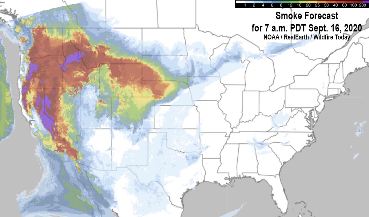
Smoke Forecast for 7 a.m. PDT Sept. 16, 2020
File image — Wildfire smoke Forecast for 7 a.m. PDT Sept. 16, 2020.

In August and September of last year some areas in the western states were under smoke advisories for weeks at a time due to numerous wildfires. If the weather in the coming months is hot, dry, and windy, and with the vegetation being dried by the multi-year drought, there could be multitudinous large fires producing conditions at least as smoky as 2020, or worse.

Smoke can have serious adverse effects on those who have asthma, COPD, heart disease, diabetes, and other chronic conditions or acute infections such as COVID-19.  Older people, pregnant women, and young children can also be at risk.

It is not practical for most of us to move to a different part of the country to find better air quality, but there are some measures that can be taken to reduce the concentration of the tiny smoke particles inside the home that can cause problems when they get into the lungs.

Closing windows will not keep smoke out of a structure. However, if you have a good quality air filtration device, the air inside the house should be better than what is outside with the windows closed. When the smoke is dense, it would be difficult for one portable air cleaner with a HEPA filter to treat the entire home, so if you only have one, put it where you spend the most time, such as the bedroom.

If you have a central air conditioner or heating system, slide-in filters can be purchased that are rated to remove very small particles like smoke and pollen. Filters are rated under various criteria — one is MERV (Minimum Efficiency Reporting Value). The higher the MERV number the better it is at removing the small particles. And medium-efficiency MERV filters in the 8 to 13 range can remove about 90 percent or more of these.

You can also tape a MERV 8 to 13 filter on a box fan and it will do a pretty good job of removing smoke in a small room. Unfortunately not all filter manufacturers use the MERV rating system. The New York Times reports that Filtrete, one of the larger filter companies, said their rating system, MPR, can be translated to MERV. “Filtrete said MPR 1900 is equivalent to MERV 13, MPR 1500 to MERV 12, and MPR 1000 to MERV 11.”

Respirator masks used during the pandemic, such as well-fitting N95, KN95 and KF94 masks, can offer protection when outside. A simple cloth mask can’t filter the PM 2.5 smoke particles.

Apps for smart phones can provide up to date air quality information. Examples include WeatherCAN and AQHI Canada in Canada, and AirNow and SmokeSense in the U.S.

Satellite photo smoke wildfires
File image — Satellite photo showing smoke from wildfires at 5:17 p.m. PDT September 11, 2020.

Labor Day fires of 2020 burned more of the Oregon Cascades than had burned in the previous 36 years combined

An analysis of the Labor Day 2020 wildfires in Oregon determined that the combination of high temperatures, unusually dry fuels, and strong winds occurring at the same time was unprecedented in the area.

2020 Labor Day fires in Oregon
2020 Labor Day fires in Oregon, research published in March 2021 by John T. AbatzoglouDavid E. RuppLarry W. O’NeillMojtaba Sadegh.

That flammable combination led to an unprecedented number of acres burned in the Oregon Cascades, about 11 percent of the mountain range, and more than the previous 36 years combined.

Below is a summary of research published last month titled, “Compound Extremes Drive the Western Oregon Wildfires of September 2020,” by John T. Abatzoglou, David E. Rupp, Larry W. O’Neill, and Mojtaba Sadegh.

“Several very large fires in western Oregon spread rapidly during an unusually strong offshore wind event that commenced on Labor Day in 2020. The Labor Day fires burned more area of the Oregon Cascades than had burned in the previous 36 years combined and very likely exceeded the area burned in any single year for at least the past 120 years. The fires damaged over 4,000 structures, led to several fatalities, placed over 10% of the state’s residents under some level of evacuation advisory, and contributed to the hazardous air quality across the Northwestern United States.

“A compound set of weather-related factors leading up to and during the fires facilitated these extreme fires. Unusually warm conditions with limited precipitation in the 60-days leading up to the fires allowed for fuels to become particularly dry and combustible by early September. Downslope offshore winds materialized during September 7–9, 2020 across the Oregon Cascades bringing exceptionally strong winds and dry air that drove rapid rates of fire spread. While neither of these individual factors was unprecedented, the concurrence of these drivers created conditions unmatched in the observational record.”

The authors called that the “Plain Language Summary.” To drill down even more into Plain Language, the conditions in Oregon were hot, dry, and windy.

The Hot-Dry-Windy Index (HDWI) is a new tool for firefighters to predict weather conditions which can affect the spread of wildfires.

It is described as being very simple and only considers the atmospheric factors of heat, moisture, and wind. To be more precise, it is a multiplication of the maximum wind speed and maximum vapor pressure deficit (VPD) in the lowest 50 or so millibars in the atmosphere. It does not consider fuel moisture.

In preliminary data that had not been peer reviewed when we wrote about it February 20, 2019, the HDWI was far more useful than the Haines Index in predicting the growth of the Chetco Bar Fire which  burned over 191,000 acres in Southwest Oregon in July, 2017.

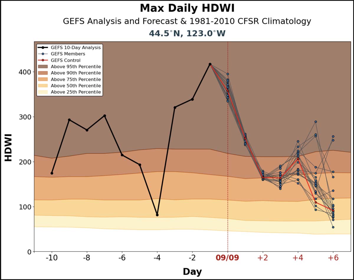
The HDWI for Oregon’s Willamette Valley was far above the 95th percentile September 6-9, 2020. During the 10 days prior to September 9 it was above the 90th percentile on nine days. The strong winds occurred September 7-9, and most of the growth of the Labor Day fires was during that period.

Hot-Dry-Windy Index
Hot-Dry-Windy Index for Oregon’s Willamette Valley for the 10 days prior to September 9, 2020, and projected for September 9-15.
satellite photo fires smoke Washington, Oregon, and California
GOES-17 photo of smoke from wildfires in Washington, Oregon, and California at 5:56 p.m. PDT Sept. 8, 2020. The photo was taken during a very strong wind event.

Thanks and a tip of the hat go out to Bob.

The Dog Fire in Guadalupe Mountains National Park has burned more than 1,800 acres

In Western Texas

8:52 a.m. MDT May 30, 2021

Dog Fire. May 24, 2021
Dog Fire. May 24, 2021. NPS photo.

Growth of the Dog Fire in Guadalupe Mountains National Park in West Texas has slowed in recent days. The lightning-caused fire 72 miles southwest of Carlsbad, New Mexico has burned 1,863 acres since it was reported May 11, 2021.

Map of the Dog Fire
Map of the Dog Fire, May 29, 2021.

Resources assigned to the fire include three hand crews (National Park Service and Texas State Forest Service), four engines (U.S. Forest Service, National Park Service, Bureau of Indian Affairs, and Texas State Forest Service), a mule string, and one Type 3 helicopter (Bureau of Indian Affairs), for a total of 86 personnel.

The National Park Service said their objective is to fully suppress the fire, “using natural and man-made barriers to keep the fire within the upper elevations of the Guadalupe Mountains National Park.”

Sawyer falling fire-damaged tree
Sawyer falling fire-damaged tree on the Dog Fire. NPS photo.
Firefighters cold-trailing
Firefighters cold-trailing on the Dog Fire, May 29, 2021. NPS photo.
Mule string on the Dog Fire
Mule string on the Dog Fire, May 21, 2021. NPS photo.