CAL FIRE reports that two firefighters deployed fire shelters at the Glass Fire September 27, 2020. The individuals were not injured, but several transport support vehicles were damaged.
The fire has burned over 50,000 acres in California’s North Bay near Santa Rosa and Calistoga.
To see all articles on Wildfire Today about the Glass Fire, including the most recent, click here.
Map of the Zogg Fire. The red dots represent heat detected by a satellite at 3 a.m. PDT Sept. 29, 2020. The red line was mapped by a fixed wing aircraft at 1:30 a.m. PDT Sept. 29, 2020.
CAL FIRE reports that the Zogg Fire southwest of Redding, California has killed three people and destroyed 146 structures.
The fire has burned at least 40,317 acres.
To see all articles on Wildfire Today about the Zogg Fire, including the most recent, click here.
Forecast for wildfire smoke at 8 p.m. PDT September 28, 2020.
Above is the forecast for wildfire smoke at 8 p.m. PDT September 28, 2020. Most of the smoke from the California fires is being transported out over the Pacific. Some of the smoke from the Wyoming and Colorado fires has blown south into New Mexico and Arizona.
Structures have burned north of St. Helena and on the east side of Santa Rosa
Updated September 29, 2020 | 4:57 a.m. PDT
3-D map of the Glass Fire. Data from a fixed wing mapping flight at 10:15 p.m. PDT Sept. 28, 2020. Looking northeast.
On Monday the Glass Fire at Santa Rosa, California grew in all directions, even as the strong winds that initially spread the fire slowed. But the high temperature and the low relative humidity combined with low moisture in the vegetation combined to enable significant fire growth.
To see all articles on Wildfire Today about the Glass Fire, including the most recent, click here.
At 7:52 p.m. on Monday CAL FIRE reported the fire had burned 36,236 acres. The information from a 10:15 p.m. mapping flight will probably result in another 11,000 acres being added to the total.
Map of the Glass Fire. Data from a fixed wing mapping flight at 10:15 p.m. PDT Sept. 28, 2020. The white line was the perimeter about 24 hours earlier.Map of the Glass Fire. Data from a fixed wing mapping flight at 10:15 p.m. PDT Sept. 28, 2020. Green lines represent the Tubbs and Nuns Fires of 2017.
Resources assigned to the Glass Fire include 26 hand crews, 80 fire engines, and 3 helicopters for a total of 1,466 personnel.
Updated September 28, 2020 | 5:22 p.m. PDT
The red line was the perimeter of the Glass Fire mapped by a fixed wing aircraft at 10 p.m. PDT Sept. 27, 2020. The red dots represent heat detected by a satellite at 2:48 p.m. PDT Sept. 28, 2020. The red dots could be extreme heat in the smoke column, or fire on the ground.
We have an updated map of the Glass Fire in the North Bay area, above, but it should be taken with a grain of salt. The red line was the perimeter mapped by a fixed wing aircraft at 10 p.m. PDT Sept. 27, 2020. The red dots represent heat detected by a satellite 512 miles overhead at 2:48 p.m. PDT Sept. 28, 2020. The red dots could be extreme heat in the smoke column, or fire on the ground. The fire is burning so intensely that debris and burning embers in the smoke have their own heat signature, confusing the sensor on the satellite. But, we have much more confidence in the mapping from the fixed wing aircraft.
Hopefully we will get another fixed wing map Monday night.
Updated September 28, 2020 | 2:16 p.m. PDT
Note: the map below is not current, but it is the only one we have available based on actual observations, in this case, from a fixed wing mapping aircraft at 10 p.m. PDT September 27, 2020. At that time the fire had burned 11,000 acres.
Glass Fire, mapped by a fixed wing aircraft at 10 p.m. PDT September 27, 2020.
The other maps, below, are derived from sensors on satellites orbiting hundreds of miles above the Earth and can show heat from fire on the ground as well as areas of the smoke column with very intense heat.
We know the Glass Fire has spread beyond the red lines on the map above. It is well established east of Santa Rosa and south of Highway 12 in the Trione-Annadel State Park.
Structures at several wineries have burned and others are threatened.
Glass Fire: This map shows heat detected by a satellite at 2:30 a.m. PDT September 28, 2020. It shows heat from fire on the ground as well as areas of the smoke column with very intense heat. Do not use for making decisions. All locations are approximate.
Strong northeast winds have caused at least two wildfires to burn together, the Glass Fire and Shady Fire. The merged fires then spread rapidly from the Calistoga and St. Helena areas of California’s North Bay, southwest into the eastern side of Santa Rosa. At 6:15 a.m. CAL FIRE reported the blaze had burned 11,000 acres.
At about 5 a.m. what we will call the Glass Fire reached the Skyhawk community on the east side of Santa Rosa north of Highway 12, and by 6 a.m. firefighters were battling it near the intersection of the highway and Oakmont Drive.
The Glass Fire started north of St Helena on the east side of Highway 29. As the northeast winds increased, a fire occurred west of the highway. It was named Shady Fire, but may have been a spot fire from the Glass Fire. The two fires burned together and continued moving southwest toward Santa Rosa.
The fire has burned numerous structures and many more are threatened. This very dangerous fire is moving faster than authorities can make evacuation notifications. If you feel threatened do not wait for official notification.
Mandatory evacuations are in effect. For information:
The fire is being driven by strong, dry winds and fuels that have built up in an area that has not seen fire in many decades. Weather stations overnight recorded humidity in the low teens and wind gusts up to 30 mph near Santa Rosa. Winds are expected to decrease through the day on Monday, but the high temperature will be 99 with the relative humidity in the teens. A Red Flag Warning and a Heat Advisory are both in effect.
Map of the Zogg Fire at 2:05 a.m. PDT Sept. 28, 2020.
A 2 a.m. mapping flight on Monday by a fixed wing aircraft determined that the Zogg Fire had spread south-southwest for about 14 miles and east for about one mile. It had come to within three miles of reaching Highway 36 the south end. The fire was very active at that time. It was first reported near Zogg Mine Road and Jenny Bird Lane, north of Igo.
The overnight flight mapped it at about 27,000 acres.
To see all articles on Wildfire Today about the Zogg Fire, including the most recent, click here.
Evacuations are in effect, including an area west of Redding, according to KRCRTV:
Update as of 7 a.m.: Areas west of Redding are under a mandatory evacuation order for the Zogg Fire. This includes Muletown Road from Placer Road north to Kanaka Lane. Diggins Way from Placer to the North is being evacuated, as well as all roads off Diggins Way and Muletown Road.
Around 4 a.m., the Redding Police Department posted on Facebook that the fire was no immediate threat to Redding.
The north end of the Zogg Fire not far from where it started. Photo from West Peak at 8:33 a.m. PDT Sept. 28, 2020.
The weather forecast predicts for Monday 14 to 16 mph winds out of the north gusting to 24, with relative humidity of 12 percent in the afternoon.
The map shows heat on the Zogg Fire detected by a satellite at 3 p.m. PDT September 27, 2020.
The map above shows heat on the Zogg Fire detected by a satellite at 3 p.m. PDT September 27, 2020. Since then the fire has spread significantly to the south or southwest across Platina Road.
CAL FIRE reported at about 7:35 p.m. Sunday that the Zogg Fire southwest of Redding, California had burned about 7,000 acres.
Updated September 27, 2020 | 7:03 p.m. PDT
Air tankers currently working on the Zogg Fire southwest of Redding, California include four S-2s, three large air tankers, four military C-130 MAFFS, and two super scoopers.
Initiation and rapid development of #ZoggFire shown in 24 fps time-lapse video from #WestPeak1 camera. Time shown from 2:40 pm to 4 pm PDT. Ridge is about 3.8 km WSW from the camera, just north of Igo, California. Smoke first appears on camera at 2:43 pm. Via @jamesinho. pic.twitter.com/y7T74gqKZq
Map showing the location of the Zogg Fire at 3:30 p.m. PDT Sept. 27, 2020.
The Zogg Fire that started southwest of Redding, California at about 2:40 p.m PDT Sunday September 27 spread rapidly to the southwest Sunday afternoon. It was reported about a mile north of Igo, 8 miles west of Highway 273, and five miles south of Whiskeytown Lake.
At 4 p.m. a spot fire was observed near Platina Road and Newscott Lane, about three miles southwest of where the fire was first reported.
By 5:10 p.m. it had burned 1,000 acres, according to CAL FIRE.
Zogg Fire, looking east from West Peak at 3:46 p.m. PDT Sept. 27, 2020. AlertWildfire.
Zogg Fire, looking east from Ducket at 3:32 p.m. PDT Sept. 27, 2020. AlertWildfire.
The National Weather Service has issued a wind warning for the area, for 15 to 25 mph northeast winds gusting to 40 mph, or up to 60 mph in isolated locations.
This article was first published at Fire Aviation September 24, 2020
The Australian Transport Safety Bureau (ATSB) has released an interim report about the January 23, 2020 crash of a C-130, Air Tanker 134, that killed the three crewmembers on board. This follows the preliminary report the agency issued in February, 2020. The aircraft was known as Bomber 134 (B134) in Australia.
“The interim report does not contain findings nor identify safety issues, which will be contained in the final report. However, it does detail the extensive evidence gathered to date, which has helped ATSB investigators develop a detailed picture of this tragic accident’s sequence of events,” said ATSB Chief Commissioner Greg Hood.
Tanker 134 (B134) at Medford, Oregon July 27, 2019. Photo by Tim Crippin.
It was very windy on January 23, with a forecast for the possibility of mountain waves. Before the incident a birddog, similar to a lead plane, and Bomber 137 (B137), formerly Tanker 138, a Boeing 737 that Coulson sold to New South Wales, was tasked to drop on a fire in the Adaminaby area. Based on the weather the birddog pilot declined the assignment. After B137 made a drop on the fire, the crew reported having experienced uncommanded aircraft rolls up to 45° angle of bank (due to wind) and a windshear warning from the aircraft on‑board systems.
After completing the drop, the B137 crew sent a text message to the birddog pilot indicating that the conditions were “horrible down there. Don’t send anybody and we’re not going back.” They also reported to the Cooma FCC that the conditions were unsuitable for firebombing operations. During B137’s return flight to Richmond, the Richmond air base manager requested that they reload the aircraft in Canberra and return to Adaminaby. The Pilot in Command (PIC) replied that they would not be returning to Adaminaby due to the weather conditions.
B134 was dispatched to the fire at Adaminaby. While they were in route, the PIC of B137 called to inform them of the actual conditions, and that B137 would not be returning to Adaminaby.
After arriving at Adaminaby the PIC of B134 contacted the air operations officer at the Cooma FCC by radio and advised them that it was too smoky and windy to complete a retardant drop at that location. The Cooma air operations officer then provided the crew with the location of the Good Good Fire, about 58 km to the east of Adaminaby, with the objective of conducting structure and property protection near Peak View. Again, there was no birddog operating with the air tanker.
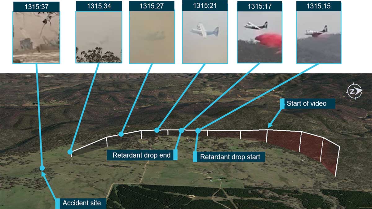
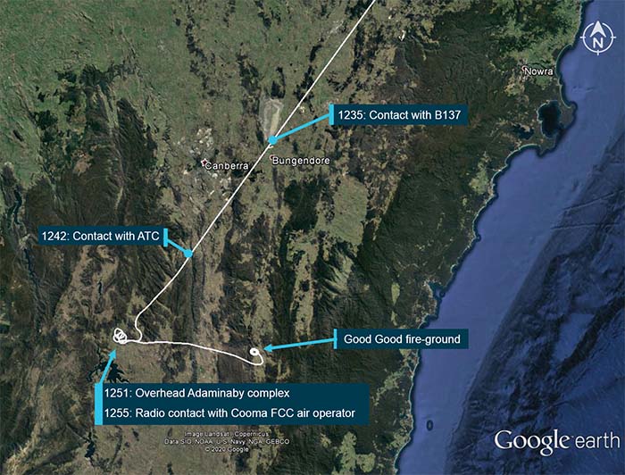
Flight path overview (in white), including the times and locations of where the crew of B134 was in communication with others. From the report.