Power poles treated with fire resistant paint survived the Sheep Fire

Sheep Fire INL smoke fire
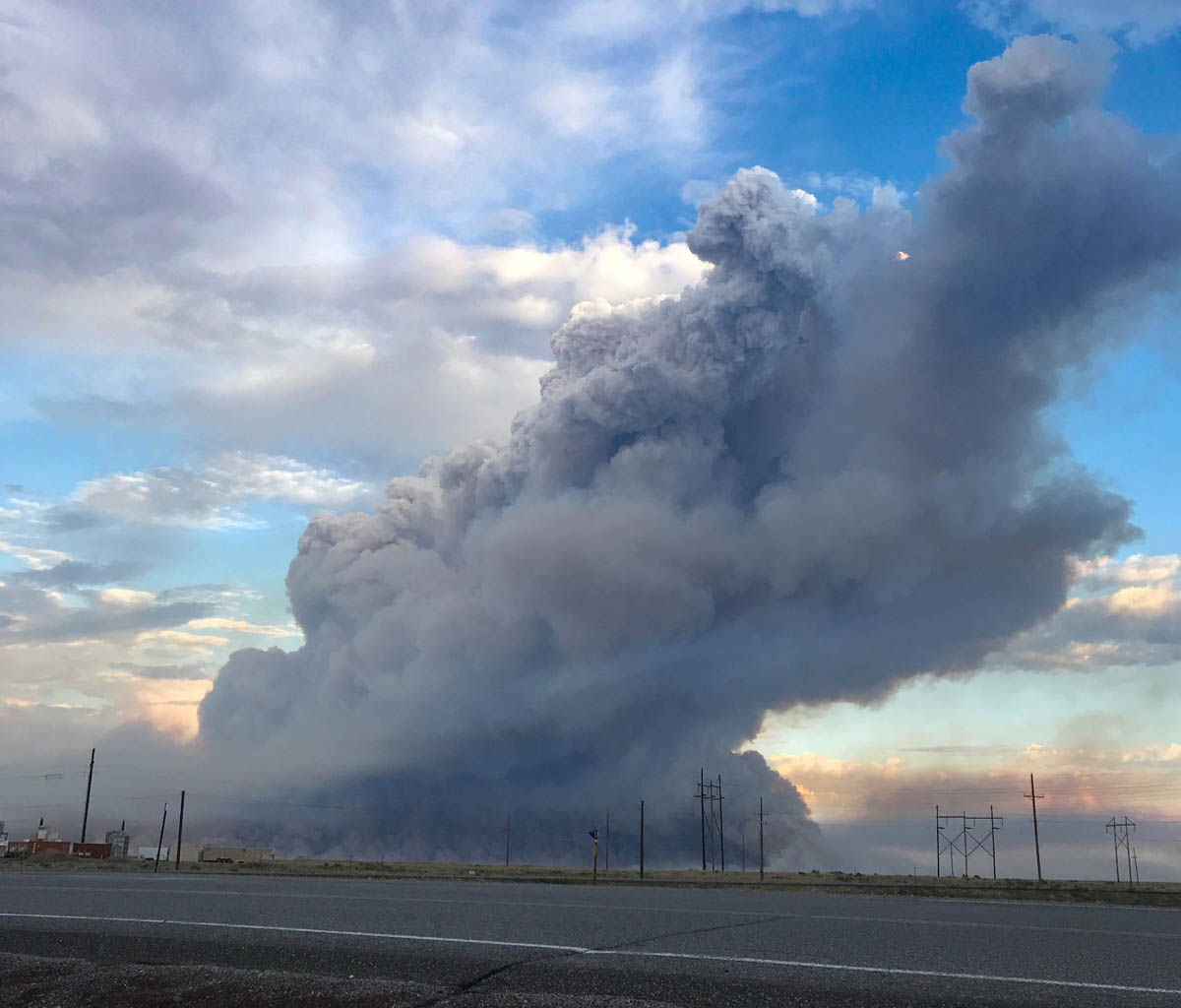
A smoke column over the Sheep Fire in Eastern Idaho, July, 2019. BLM photo.

(From the Bureau of Land Management)

Mitigation efforts reduce impacts of 112,000 acre Sheep Fire

The lightning caused Sheep Fire started on the evening of July 22 on the Idaho National Laboratory (INL) site in eastern Idaho. The area has a history of large, wind-driven wildfires that burn quickly through the grass and sagebrush desert. The Sheep Fire was no exception. It quickly became INL’s largest fire in history consuming over 112,000 acres.
power poles damaged fire wildfire
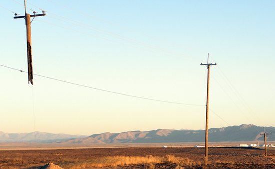
Power pole damaged during the T 17 Fire at the INL in 2011. BLM photo.

Firefighters worked hard—and successfully—to save facilities from the wind-driven fire, but infrastructure losses were incurred.  Transmission lines providing electricity to multiple counties across eastern Idaho are prevalent in the area, and their wooden power poles were particularly at risk. Approximately 61 rights of way for transmission lines cross BLM lands near INL. The INL itself has 4,000 power poles situated in brush and grass fuels.

During the active fire seasons of 2010 and 2011, which burned over 160,000 acres of both BLM and INL lands, power poles often burned, resulting in power outages, public safety issues and unplanned replacement costs. After the 2011 fire season, BLM fire mitigation specialists from the Idaho Falls District met with local power company officials, county officials and the INL. They discussed solutions to the considerable loss of power poles incurred from wildfires. The BLM proposed using a latex-based fire retardant paint on power poles to help protect them from burning.

fire retardant paint damaged wildfire fire
Fire retardant paint applied to power poles. BLM photo.

The INL decided to implement this proposal—having lost almost 60 power poles just in 2011. Although the treatment cost $100 per pole, the INL staff was willing to make that investment due to the high replacement cost of $1,200 to $2,500 per pole. Over the next two years, INL painted 3,000 of its power poles 5 feet up from the ground with the fire retardant paint. INL prioritized power poles receiving the paint based on service area, damage risk and vegetation density.Every pole painted in the latex-based fire retardant paint survived the Sheep Fire. Even poles that had not been repainted since their initial coat in 2012 and 2013 survived.

INL’s mitigation efforts successfully kept power to its grid during the Sheep Fire. While wildfires will continue to threaten infrastructure, Idaho Falls District BLM will continue finding innovative and cost effective partnerships in eastern Idaho to mitigate wildland fire impacts.


UPDATE: The product used by the INL is Osmos Fire-Guard Wood Pole Protection.

Fishhawk Fire grows to over 4,500 acres west of Cody, Wyoming

(UPDATED at 7 p.m. MDT September 4, 2019)

map Fishhawk Fire Cody Yellowstone
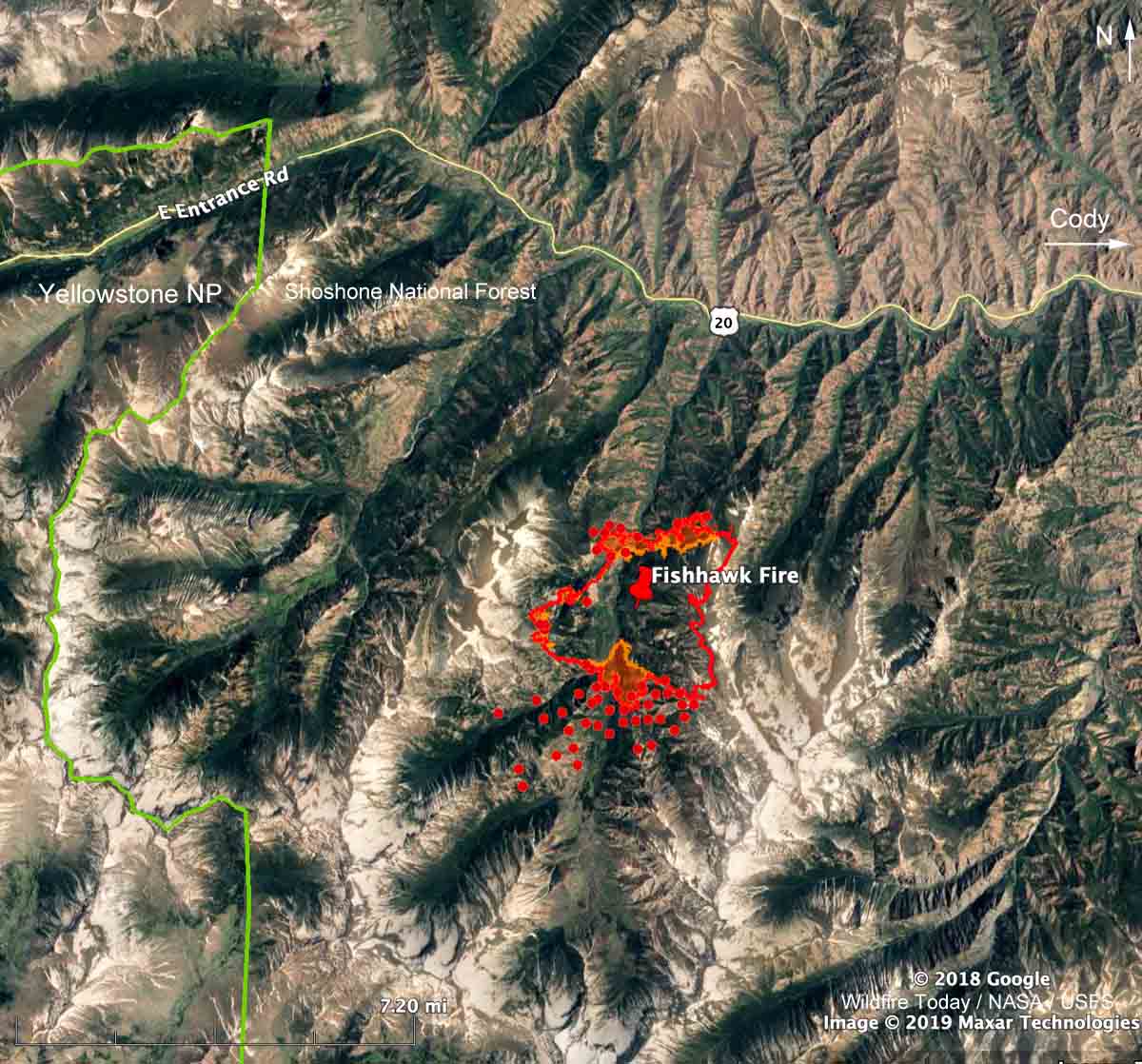
Map showing the location of the Fishhawk Fire. The red line was based on a USFS mapping flight at 8:19 p.m. MDT September 3, 2019. The red dots represent heat detected by a satellite at 2:12 p.m. MDT September 4, 2019.

The red dots on the map above represent heat detected on the Fishhawk Fire by a satellite at 2:12 p.m. MDT September 4, 2019. It is uncertain if they indicate actual surface spread of the fire toward the southwest, or if the heat was detected in an intense convection column in the atmosphere above the fire.

The smoke in the upper atmosphere was blowing off to the east, but perhaps lower level local winds, an up-canyon breeze, could have pushed the smoke and the fire to the south. During the fixed wing mapping flight at 8:19 p.m. on September 3 there was intense fire activity on the south edge of the fire.

(To see all articles on Wildfire Today about the Fishhawk Fire, including the most recent, click here.)

The Fishhawk Fire is 38 miles west of Cody, Wyoming, six miles east of the east entrance to Yellowstone National Park.

Scroll down to see more maps and information.


(UPDATED at 1:42 p.m. MDT September 4, 2019)

map Fishhawk Fire Cody Yellowstone
3-D map showing the location of the Fishhawk Fire at 8:19 p.m. MDT September 3, 2019, looking north.. Based on data collected from a USFS mapping aircraft. The orange shading indicates intense heat.

A mapping flight Tuesday night found that the Fishhawk Fire 38 miles west of Cody, Wyoming spread up to about one-quarter mile in all directions Tuesday except on the east side where it has reached a steep hog-back ridge 10,000 to 11,000 feet above sea level.

A Type 2 Incident Management Team will in-brief Wednesday prior to assuming command of the fire.

The resources assigned to the fire as of Tuesday evening included no hand crews, 3 engines, and 3 helicopters for a total of 29 personnel.

The 4,581-acre fire so far is confined to a north-south drainage that has a similar high elevation ridge on the west side. The fire is not being fully suppressed, so it is possible that firefighters are expecting the 10,000-foot ridges with light fuels to contain the perimeter on the east and west sides.

About 3.5 miles to the north is a highly-traveled highway, 14/16/20, leading from Cody to the east entrance of Yellowstone National Park. If it crosses the highway it would be burning on primarily south-facing slopes which would normally be very conducive to additional fire spread. However it would most likely be burning in the footprint of the 2008 Gunbarrel Fire that burned at least 67,000 acres. The light vegetation in the fire scar would present less resistance to control. Like the Fishhawk Fire, the Gunbarrel Fire was not suppressed. On August 15, 2008 the Shoshone National Forest had a plan for the maximum manageable area to cover 416,000 acres.

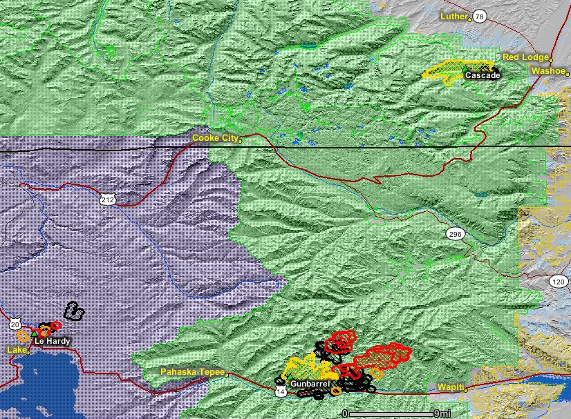
Map of the Gunbarrel Fire
Map of the Gunbarrel Fire (bottom-center) August 3, 2008. At the time it was about 22,000 acres. Map from Wildfire Today. Click to enlarge.

In their long term plans, fire managers on the Fishhawk Fire should plan for extreme winds. On August 28, 2008 the Powell Tribune wrote this about the Gunbarrel Fire :

“The winds are just howling,” Clint Dawson said Wednesday, describing the wind’s rate around the Gunbarrel Fire.

Dawson is the zone fire manager for Shoshone National Forest.

In the valley — in the vicinity of the newly-relocated Gunbarrel Fire camp at Buffalo Bill State Park — the wind was gusting to 40-60 mph in the early afternoon on Wednesday. The new incident command camp is just above the reservoir west of Cody.

An aircraft flying over the fire Wednesday reported winds reaching 115 mph at 11,000 feet, Dawson said.

The fire was spotting on the east side of 12,000-foot high Trout Peak, according to an incident report.

Continue reading “Fishhawk Fire grows to over 4,500 acres west of Cody, Wyoming”

Portions of California expected to see above average wildfire activity

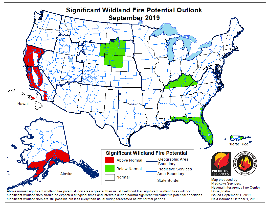
September 2019 wildfire outlook

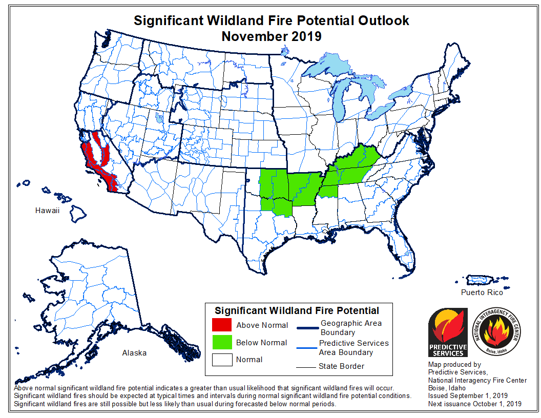
On September 1 the Predictive Services section at the National Interagency Fire Center issued their Wildland Fire Potential Outlook for September through December. The data represents the cumulative forecasts of the ten Geographic Area Predictive Services Units and the National Predictive Services Unit.

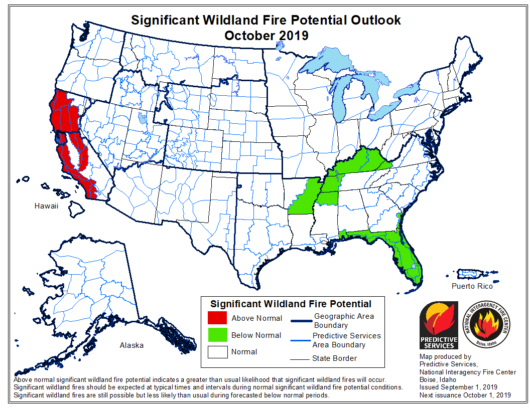
If NIFC’s analysis is correct, California will be one of two states expected to have areas with above average potential for wildfires, and those sections of California will shrink through December until the only areas remaining are the mountains and coasts from Santa Barbara south to the Mexican border. Southern Alaska could also have above normal fire activity in September.

Below:

  • An excerpt from the NIFC narrative report for the next several months;
  • More of NIFC’s monthly graphical outlooks;
  • NOAA’s three-month temperature and precipitation forecasts;
  • Drought Monitor;
  • Vegetation greenness map;
  • Keetch-Byram Drought Index.

From NIFC:

“Due to the recent lack of rainfall, areas of concern have emerged and are expanding to include Texas, California, Nevada, Utah and southwestern Wyoming – all of which have generally seen less than 25% of average precipitation during the past month. Extended periods of dry conditions across New Mexico and the southern Great Plains are also leading to the development and intensification of drought conditions.

“Entering September, warmer and drier than average conditions are expected to occur along the West Coast, which may persist well into fall. However, the passage of periodic wet systems should gradually end the fire season from north to south across the Northern Rockies, Central Rockies and Great Basin. Texas is expected to remain warmer and drier than average, which may, in turn prolong their season well into fall. Warmer and drier than average conditions are expected across the piedmont of the southern Appalachians, but wet antecedent conditions should preclude fire activity there.

“As the fall progresses, fire activity should relent over the Pacific Northwest and eventually Northern California during October. Southern California will likely be the last area to see fire activity conclude in 2019 as offshore winds and dry fuels may keep fire activity going south of Pt. Conception into December. In Alaska, overall warmer and wetter than average conditions are expected until the state enters winter.”


October 2019 wildfire outlook

November 2019 wildfire outlook

Continue reading “Portions of California expected to see above average wildfire activity”

Wildfire activity this summer has been far below average in Western U.S.

Jalama Fire Santa Barbara County
The Jalama Fire burned 1.9 acres September 1 on Jalama Road, six miles from California Hwy. 1 near Lompoc. Santa Barbara County Fire Department photo.

The Predictive Services section at the National Interagency Fire Center confirmed what wildland firefighters across the West already know — so far this has been a really slow fire season.

Here is what NIFC wrote on September 1, 2019:


“National fire activity continued to lag far below average during this past August. The residual effects of the abundant late spring and early summer moisture may be the primary reason behind the discrepancy between this year’s low number of acreage impact and recent busy summers. Simply put, live fuels are not as receptive as usual compared to most Augusts and fire growth has been more moderate through fuel beds dominated by live vegetation.

“A substantial lightning event did occur across the West during August 7-10, which would be enough to lead to a large increase in fire activity during most years. While this lightning event spurred an increase in initial attack shortly afterward, few of new ignitions went on to become large incidents. Temperatures across the West were, on average, 2 to 7 degrees below normal. Conversely, the eastern half of the country experienced above average temperatures, mainly during the first part of August. Out West, the frequency of long-duration heat events were few and mostly limited to 3 to 5 day spans. Precipitation amounts were generally below average across the Continental U.S. except across the northern and central Great Plains.”

Lawsuit filed against Southern California Edison for allegedly causing the Rey Fire

The fire burned over 32,000 acres north of Santa Barbara in 2016

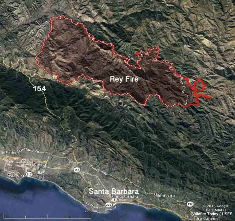
Map Rey Fire August 25 2016
Map of the Rey Fire. The red line was the perimeter at 10 p.m. PDT Aug. 25, 2016. The white line was the perimeter at 10 p.m. PDT Aug. 23.

The federal government has filed a lawsuit against Southern California Edison and two other companies for allegedly allowing the Rey Fire to ignite north of Santa Barbara, California on August 18, 2016. The complaint that was filed in U.S. District Court August 17, 2019 contends that of the 32,606 acres that burned in the fire, 19,752 acres were within the Los Padres National Forest. Also named in the lawsuit were Frontier Communications (a telecommunications company) and Utility Tree Service (a tree trimming company).

The fire started when a tree fell on power and communications lines. The court document states, “SCE and UTS were informed of the potential danger the tree that fell on the subject lines posed, were aware of the danger that said tree might fall on the subject lines before it fell, and failed to take any action to prevent it from falling on the subject lines.”

The filing says Frontier failed to, “…maintain proper vegetation clearance around and below its communication lines, and using a device, including its communication lines and equipment, which may cause a fire and failure to take reasonable precautions to avoid starting and spreading a fire.”

The Government alleges SCE violated the terms of its Special Use Permit for the powerlines by “…failure to prevent damage to the land and property of the United States; to take reasonable precautions to prevent and suppress fires; to construct, maintain and operate its equipment and power lines in a safe and effective working order; and to properly and safely maintain, operate, use and occupy the premises of National Forest System lands.”

On the date the suit was filed, SCE had not paid any of the suppression or rehabilitation costs which amounted to more than $26 million.

In addition to those costs, the Government hopes to recover costs of “wrongful injury to [National Forest] trees, loss of timber and vegetation, loss of habitat and environmental damages, damage to the soil, loss of use, scenic views, and aesthetic values”, in an amount to be determined at a trial by jury.

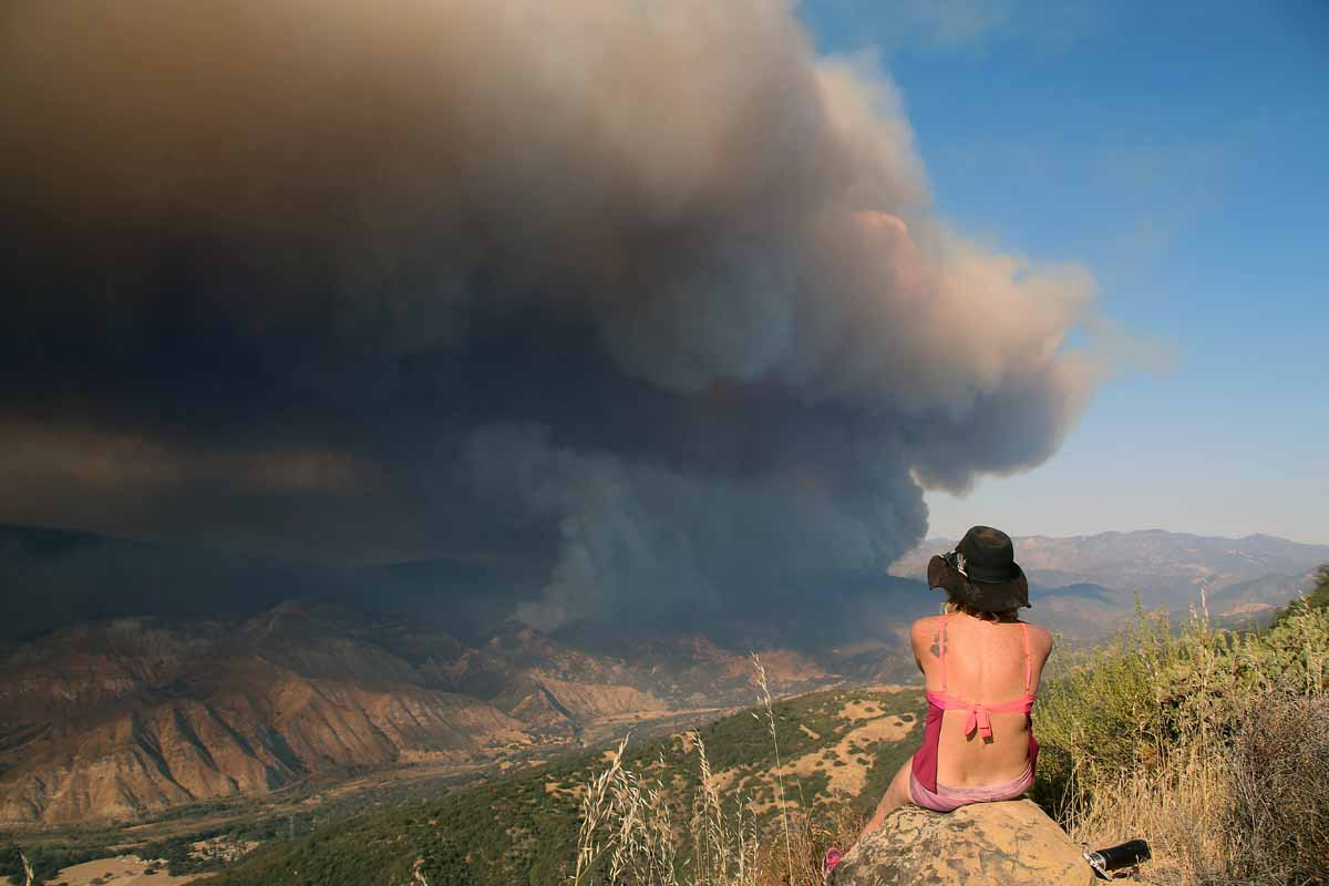
Rey Fire.
Rey Fire, August 21, 2016. Photo by Jeff Zimmerman.


Pedro Mountain Fire burns over 19,000 acres near Pathfinder Reservoir in Wyoming

Pedro Mountain Fire line construction
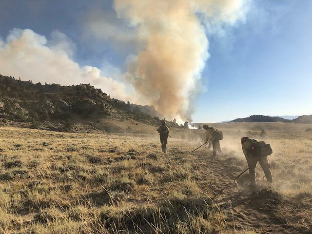
Firefighters construct fireline in preparation for burnout operations on August 28, 2019. Photo by Andrew Maue, Laramie Peak Fire Zone.

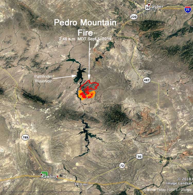
Since the Pedro Mountain Fire started from a lightning strike August 24 it has burned over 19,000 acres in southeast Wyoming. The fire is just east of the Pathfinder Reservoir, 37 miles northeast of Rawlins and 39 miles southwest of Casper. Evacuations are in effect for some areas.

From InciWeb:

Saturday’s Summary
Four hotshot crews, assisted by initial attack crews, completed a large and successful burn operation throughout the southern half of the fire on Saturday. The control line stretched for several miles, including Gooseberry Canyon and areas just west of Carbon County Road 291. This reduced the amount of vegetation in the fire’s path and is a key strategy in the effort to protect homes and property.

Sunday’s Operations
While some crews will continue working in the area of yesterday’s successful efforts in the south, other firefighters and engines will be rerouted to the northeast corner near Rocky Gap, where infrared flights show pockets of heat with the potential to spread to uncontrolled fire line. Fire prediction tools used by the incident management team show the fire has the most potential to spread to the east/northeast in the next 24 hours, based on weather and topography. Addressing these hot spots will limit significant fire growth and assist in closing up the containment line.

Crews are working under red flag warning conditions again today, with temperatures in the 90s, low humidity, and strong winds.

The evacuations and closures listed below remain in effect because firefighters are still engaged in efforts to stop the fire from spreading. With uncontrolled lines, the fire has potential to move to the east and south, putting fire and smoke closer to County Road 291. With well over 400 personnel on the fire, large numbers of crews and apparatus need to move unimpeded throughout the fire zone. The incident management team understands the public’s interest in returning to the area and will begin discussing plans with the Carbon County Sheriff’s Office to allow residents access to their homes and properties in a timely manner as soon as the area is safe from further fire spread and other impacts.

Map location Pedro Mountain Fire
Map showing the location of the Pedro Mountain Fire at 2:48 a.m. MDT September 1, 2019.

Closures / Public Safety
Evacuations are still in place for the following areas: Pedro Mountain Estates, Pedro Mountain Ranch Road, and Cardwell Ranch.

Natrona County Road 407 / Carbon County 291 (also known as Kortes Road) is closed from the intersection of Natrona County 408 (also known as Fremont Canyon) south to Leo/Sage Creek until further notice due to fire operations and public safety. The closure includes all roads west of the above location to Pathfinder Reservoir.