Forest Service plans 75,000-acre fuel treatment project northwest of Wenatchee, Washington

Upper Wenatchee Pilot Project
Upper Wenatchee Pilot Project. USFS map.

The U.S. Forest Service is planning a 75,000-acre project in central Washington intended to restore forest health, reduce wildfire risk, improve wildlife habitat, and improve watershed function on a landscape scale.

The area is northwest of Wenatchee and north of Leavenworth.

The work may include both terrestrial and aquatic components such as prescribed fire, stream improvement, road system work, as well as commercial and non-commercial thinning.

Much of the area within the perimeter of the project does not have a fire history recorded within the last several decades.
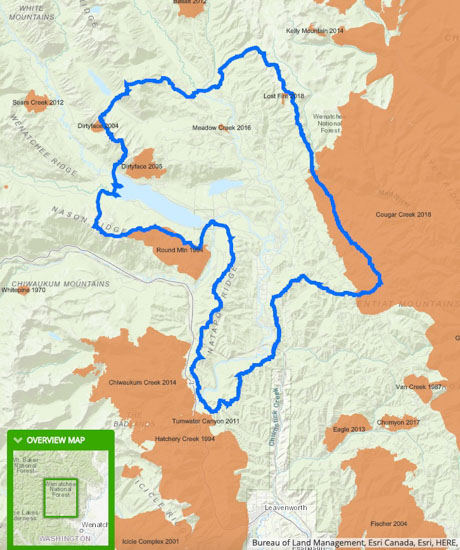
Upper Wenatchee Pilot Project
Upper Wenatchee Pilot Project(in blue), showing wildfire history. USFS map.

“With collaboration and sound science, it is possible to move towards a sustainable landscape that is better for the forest and communities alike” said Wenatchee River District Ranger Jeff Rivera. “We want to hear from you early on about wildlife, fish, fire, roads, and other important considerations for this landscape and the people who use it and live by it.”

Forest Service staff will be on hand to answer questions and share an interactive map at an open house Tuesday March 12, 2019 from 6-7:30 pm at the Lake Wenatchee Recreation Club at 14400 Chiwawa Loop Road Leavenworth, WA. This meeting will also be available via Facebook Live. The 30-day formal scoping comment period began February 25, 2019. A draft Environmental Analysis is expected in the fall of 2019.

More information about the project.

Are stand replacement fires “bad”?

Cranston Fire
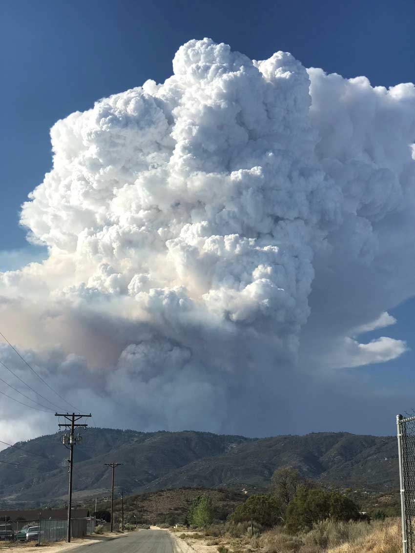
Cranston Fire, July, 2018. InciWeb photo.

The video below, paid for by a grant from the U.S. Forest Service, advocates active management of forests as one of the methods of preventing catastrophic wildfires. Most land managers and members of the public will agree with that very general statement, with exceptions for certain parks and wilderness areas.

The video defines active management as thinning to reduce fuels,  prescribed fires, and “managing natural fires when they start”. It begins with Doug Grafe, Fire Protection Chief of the Oregon Department of Forestry stating,”It’s the public perception that catastrophic stand replacement fires are bad. And they are.”

The interviewer enthusiastically said, “Yes they are”.

Chief Grafe continued, “And they’re not natural.”

At the end of the video the narrator says “fire is complex”.

Agreed. It is too complex to throughly explain in a 96-second film which is apparently intended to shape public opinion about how to manage forests.

Not all stand replacement fires, in which most or all overstory trees are killed, are catastrophic, unnatural, or bad. Fires in lodgepole pine, for example, are either creeping and slow moving or rapidly spreading, intense, stand replacing crown fires occurring at 50 to 300-year intervals.

In addition to prescribed fire, thinning, and fuel management, “active forest management” in recent years has been a dog whistle for increasing logging, used by lobbyists and others that make their living from the timber industry. The president used the term along with “health treatments” in a Presidential Order signed on the Friday before Christmas in which he directed a 37 percent increase in timber harvesting.

The moral of this story is, active forest management in most landscapes has many benefits, but beware of how it is defined.

Fire “is like giving the forest a bath”

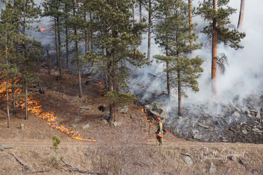
Whaley Prescribed Fire Black Hills of South Dakota
The Whaley Prescribed Fire in the Black Hills of South Dakota, January 13, 2016. Photo by Bill Gabbert.

In this video, Matt Jolly, an ecologist at the U.S. Forest Service’s Rocky Mountain Research Station, talks about the natural and important role of fire in maintaining a healthy ecosystem. He explains that fire “is like giving the forest a bath”.

Kimberly Lightley earns Lead by Example Award

Paul Gleason Lead by Example Award
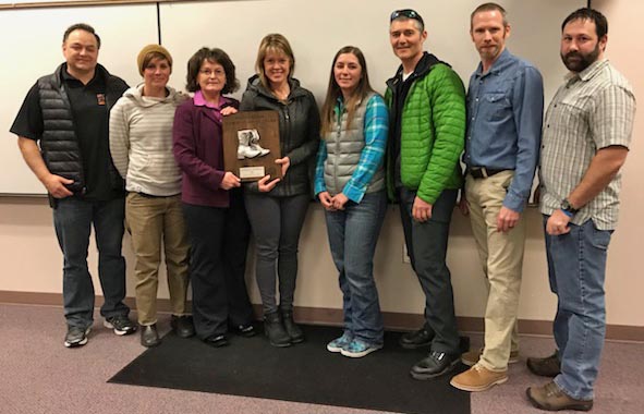
L to R: Ted Mason, Ashleigh D’Antonia, Director Shawna Legarza, Kimberly Lightley, Monica Morrison, John Wood, Jim Shultz, and Mike Ellsworth. USFS photo.

Kimberly Lightley has been selected as one of the recipients for the 2018 Paul Gleason Lead by Example Award. Three individuals and one group from across the wildland fire service have been chosen to receive this national award which was was created by the National Wildfire Coordinating Group Leadership Committee to remember Paul Gleason’s contributions to the wildland fire service. During a career spanning five decades, Mr. Gleason was a dedicated student of fire, a teacher, and a leader. The intent of the award is to recognize individuals or groups who exhibit this same spirit and who exemplify wildland fire leadership values and principles. Ms. Lightley’s work in support of the Wildland Fire Leadership Development Program has been a demonstration of motivation and vision.

Based out of the U.S. Forest Service’s Washington Office as a Critical Incident Specialist, she was recognized for development of the Stress First Aid Program for wildland firefighting. As a survivor of the South Canyon tragedy, her exemplary leadership and bravery to lead and bring to light the insufficiencies in how we care for each other following critical, stressful incidents is commendable. The lessons Ms. Lightley learned from her experience will become a foundation so future employees—regardless of their agency—will not have to navigate the path of healing on their own.

Past recipients of the Paul Gleason Lead by Example Award, since 2003.

Firefighter from Mexico trains with hotshot crew

Mexican firefighter Fulton Hotshots
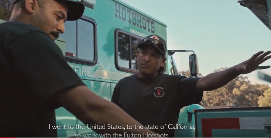
A firefighter from the National Forestry Commission of Mexico trains with the Fulton Hotshots. Screenshot from the video below.

This video features a firefighter with the National Forestry Commission of Mexico (CONAFOR), Fernando Navarro Jiménez, who for several months joined the U.S. Forest Service’s Fulton Hotshots on the Sequoia National Forest in California. It shows the impact of the experience on him and CONAFOR as well as the cooperation between the U.S. Agency for International Development, the USFS, and Mexico.

Researchers demonstrate that it is possible to accurately measure wildfire rate of spread from an orbiting aircraft

measure wildfire rate of spread from aircraft
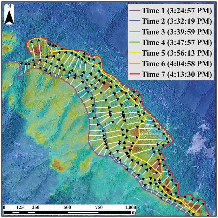
Figure 3. Fire spread sequence for Detwiler Fire. Active fire fronts and fire spread vectors are portrayed for the seven-image sequence on 20 July 2017. The background image is a fusion of NAIP colour (depicting vegetation fuels and topography) with a colour density sliced version of the seventh FireMapper 2.0 image.

Now that federal land management agencies are being forced by an act of Congress to begin providing to fire managers the real time location of fires and firefighting resources, it opens a range of cascading benefits beyond just enhancing their safety and situational awareness.

Fire Behavior Analysts that could continuously observe the fire with infrared video from a manned or unmanned aircraft orbiting above the air tankers could make much more accurate, valuable, and timely Fire Behavior Forecasts. The fire spread computer models could be fine-tuned to be more accurate and their outputs could be displayed on the map along with the locations of firefighters who carry tracking devices, enabling the Operations Section Chief to make better-informed strategic and tactical decisions.

But until recently it was not known if georeferenced infrared imagery from an orbiting aircraft was accurate enough to be used for determining the rate of spread.

The short answer is, yes. A paper published last week indicates that the accuracy is sufficient. (FYI — the document is written for other scientists and not for practitioners.)

Now the question becomes, will the federal land management agencies actually implement the program to track the real-time location of fires and firefighters, or will they slow-walk it into oblivion like the Congressional orders to purchase a new air tanker, convert seven HC-130H Coast Guard aircraft into air tankers, and the repeated requests from the GAO and Inspector General to provide data about the effectiveness of firefighting aircraft?

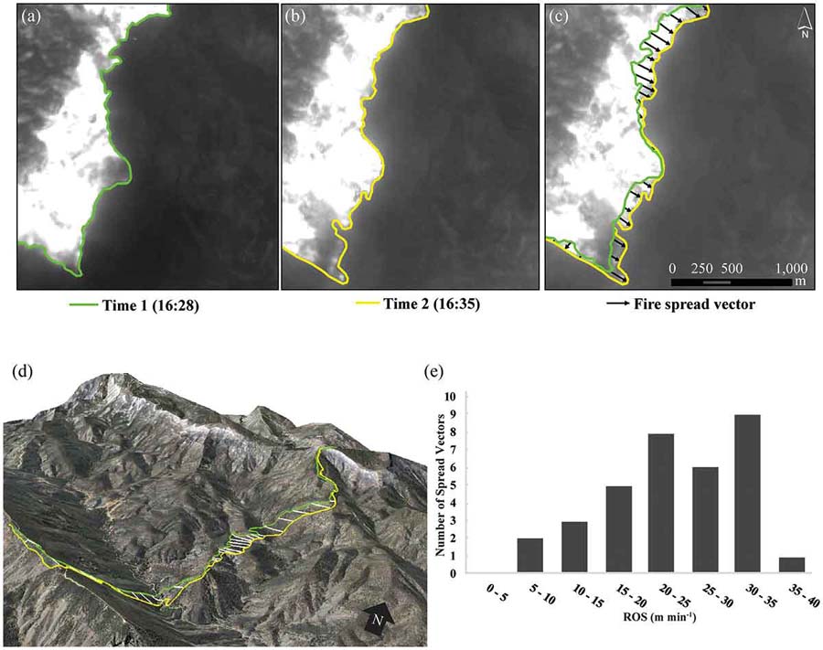
measure wildfire rate of spread from aircraft
Figure 7. Wildfire spread during the Rey Fire on 21 August 2016. (a) Time 1 fire front. (b) Time 2 fire front (7 min later). (c) Fire spread vectors and ROS statistics. (d) 3-D perspective image depicting active fire front and spread vectors. (e) Histogram depicting frequency distribution of ROS estimates for all spread vectors in the two-pass imaging sequence.

Unfortunately even though United States taxpayers funded the research through the U.S. government’s National Science Foundation (grant number G00011220), only some of us will be able to read the fruits of the research since it is not an Open Access document. After it is viewed 50 times free access will be shut off.

Open Access logo
Open Access logo

It is published at Taylor and Francis Online, a private company based in the United Kingdom. So by the time you read this the company may be charging people to read the document. (UPDATE at 7:42 a.m. MST February 21, 2019: General access to the document has been shut off. The company is now charging $50 to view it for 24 hours.)

Not allowing taxpayers to read government funded research unless they pay for it again is reprehensible.

The document is at Taylor and Francis Online: Assessing uncertainty and demonstrating potential for estimating fire rate of spread at landscape scales based on time sequential airborne thermal infrared imaging. By: Douglas Stow, Philip Riggan, Gavin Schag, William Brewer, Robert Tissell, Janice Coen, and Emanuel Storey