This is the prediction for the distribution of wildfire smoke for 6 p.m. MDT July 9, 2018. It is an experimental forecast from NOAA’s Earth System Research Laboratory.
The scientists expect significant smoke impacts Monday in areas of Oregon, Washington, Idaho, and Montana.
Most of the smoke is coming from the Klamathon Fire on the Oregon/California border and the Martin Fire in Northern Nevada.
Above: screenshot from the video of the Martin Fire.
(UPDATED at 8:58 a.m. MDT July 9, 2018)
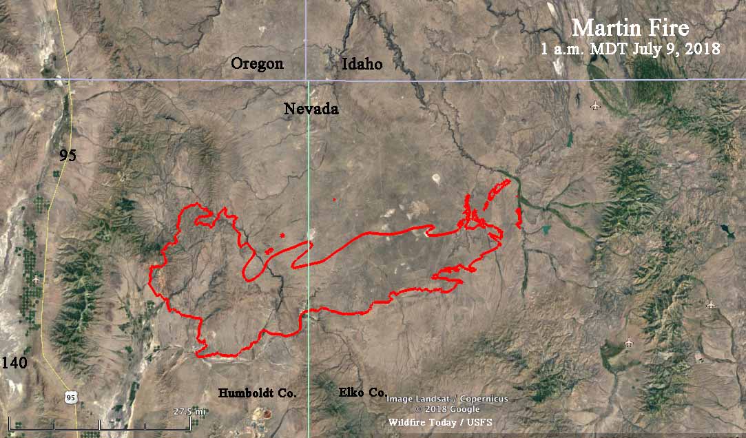
A new map of the rapidly growing Martin Fire in Northern Nevada reveals that it has exploded to 399,429 acres, according to the Incident Management Team. During an overnight fixed wing mapping flight some areas of light vegetation burned and then cooled, again making it difficult to fill in some of the holes where no heat was detected by the sensors.
The Martin Fire is 57 miles long, west to east.
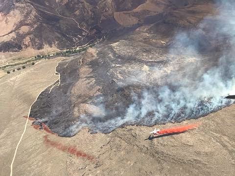
Map showing heat detected on the Martin Fire. The most current data was collected at 1 a.m. MDT July 9, 2018.A DC-10 makes a retardant drop on the Martin Fire. Photo uploaded to InciWeb June 6, 2018.
According to satellite data acquired at 1:54 p.m. MDT Sunday the Martin Fire in Northern Nevada was extremely active at that time. It may have progressed over 20 miles during the previous 24 hours, reaching a total length of approximately 54 miles, west to east. At 1:54 p.m. it was 13 miles west of highway 11/226. Our very, very unofficial guestimate of the size at that time was about 380,000 acres. This is difficult to determine, because much of the vegetation that is burning is light, and can burn and then cool before the next infrared-sensing satellite overflight, occurring about every 12 hours. Our guess involved assuming some of the “unburned” holes had actually burned, but were undetectable by the satellite.
The map below shows approximately the same area as the one farther down dated July 7.
Martin Fire, July 7, 2018.
(UPDATED at 2:21 MDT July 8, 2018)
InciWeb is saying the Martin Fire has burned 164,000 acres but this map puts it at over 239,000 acres.
(Originally published at 1:45 p.m MDT July 8, 2018)
The robotic cameras operated by the Nevada Seismological Lab have scored again, capturing some great time-lapse video of the Martin Fire in Northern Nevada as pyrocumulus clouds are being created. The video was shot from 6 to 7 p.m. on July 7, 2018.
The Martin Fire has burned 164,000 acres according to InciWeb, and on Saturday it spread from Humboldt County into Elko County.
Fire perimeter produced by the Incident Management Team. Text notations by Wildfire Today.
Firefighter suffers severe burns when his engine is burned over
(Originally published at 6:18 a.m. PDT July 8, 2018)
After burning 31 homes and killing one civilian in Hornbrook California, the Klamathon Fire has spread almost a mile across the state line into Oregon. Jefferson Public Radio is reporting that 10 people are missing in Siskiyou County, but the agencies have not provided any details.
Firefighter Brandon Feller suffered severe burns when his engine was burned over. He is being treated at the UC Davis burn center and they expect a full recovery. A GoFundMe account has been created for Mr. Feller.
Map of the Klamathon Fire, July 7, 2018.
Evacuation orders have been issued for the communities of Hornbrook, Hilt, Colestin and Irongate Reservoir. Some locations in Oregon’s Jackson County have also been evacuated.
A wedding had to start early and was cut short when evacuation orders were issued.
My niece about to get married 1 hour early in impromptu shortened ceremony conducted by my husband (without most of the guests) as the #klamathonfire raced down the hill and we were given mandatory evacuation orders. Everyone is safe; we don’t know about the property. pic.twitter.com/Gy12hbNgtM
CAL FIRE reported Saturday that the fire has burned 22,000 acres, but our very unofficial analysis of a Saturday night mapping flight found that it has spread to an estimated 32,000 acres.
Saturday evening the 747 Supertanker made its first retardant drop of the year on the Klamathon Fire after being activated on a Call When Needed contract with CAL FIRE. From the flight tracking, it appeared that it dropped on the far north end of the fire in Oregon, and then returned to Sacramento McClellan Airport.
Firefighters on the 1,000-acre Valley Fire on the San Bernardino National Forest in Southern California are experiencing unusual weather. Extreme heat was on the agenda Friday, and Saturday brought several thunderstorms through the area, resulting in some flooding and debris flows along Valley of The Falls Drive and Highway 38.
The Arrowhead Hotshots, the National Park Service crew that posted these photos on Twitter, wrote Saturday night about conditions on the fire:
From one extreme to the next. Hot, fire, thunderstorms, lots of rain, hail, flash flood.
The Incident Management Team reports that the fire is far from being out:
The higher elevations of the fire have not seen significant rainfall, and continue to burn. The fire is moving north and east, higher into the San Gorgonio Wilderness Area.
The map shows the prediction for the distribution of near-surface wildfire smoke at 6 p.m. MDT July 7, 2018. The states that are the most affected include portions of California, Oregon, Nevada, Idaho, Montana, Wyoming, Utah, Colorado, Nebraska, South Dakota, and North Dakota.
On Saturday there is a slight chance of isolated dry lightning strikes across the eastern San Gabriel Mountains during Red Flag Warning conditions
Above: Photo taken from the back yard of the USFS District Office in Alpine, CA during the West Fire July 6, 2018. USFS photo.
(Originally published at 9:20 a.m. PDT July 7, 2018)
The predictions for record heat in Southern California were accurate Friday as high temperatures soared into the triple digits. In downtown Los Angeles the old record for the date was broken by 10:15 a.m. when it hit the previous mark set in 1992 of 94 degrees. By the end of the day it was 108. The temperature at UCLA reached 111 degrees, the hottest temperature ever recorded there.
Other record-setting daily temperatures Friday in Southern California:
117 – Van Nuys Airport
114 – Burbank Airport
115 – Ramona
118 – Riverside
Firefighters were challenged by not only the heat but dry winds as fires broke out in several areas.
As the temperature reached 109 degrees, U.S. Forest Service firefighters on the Cleveland National Forest found themselves in a structure defense mode at their District Office in Alpine, with the West Fire adjacent to the building’s back yard and the rest of the 400-acre blaze across the street. Live footage shot by a local TV station showed numerous structures were destroyed.
Photo taken from the front yard of the USFS District Office in Alpine, CA during the West Fire. USFS photo.
On the Santa Barbara coast sundowner winds pushed the Holiday Fire through the hills above Goleta, burning 10 to 20 homes according to fire authorities. Even into the night temperatures at the fire scene remained above 100 degrees.
At the Holiday Fire, Santa Barbara County Fire Department firefighters apply water at a home off Fairview Avenue in Goleta. SBFD photo.
The Valley Fire that started Friday has burned at least 1,000 acres near Highway 38 on the San Bernardino National Forest. At last report it was headed into the San Gorgonio Wilderness Area. Mandatory evacuation are in effect for the Forest Falls Community east of the highway. Southern California Incident Management Team 2 will be assuming command.
— San Bernardino National Forest (@SanBernardinoNF) July 7, 2018
Much of Southern California is again under a Red Flag Warning Saturday as the huge high pressure dome lingers over the area, bringing more of the same very high temperatures, 2 to 8 percent relative humidities, and gusty winds.
And just to make the situation more interesting, there is a slight chance of isolated dry lightning strikes across the eastern San Gabriel Mountains along with thunderstorm-driven winds.