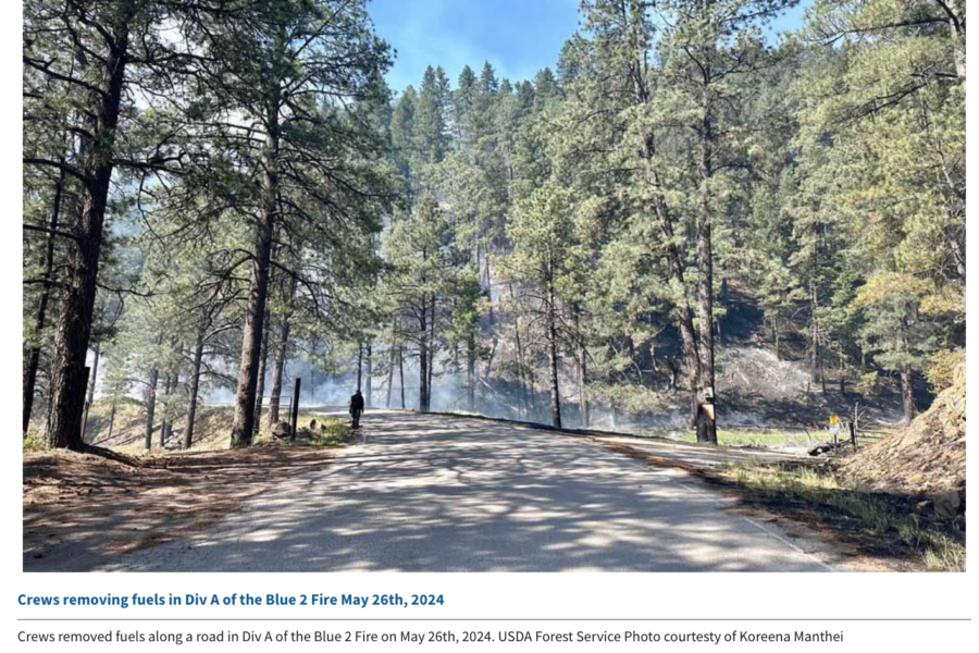
The Lincoln National Forest has issued closure orders for several trails within the White Mountain Wilderness Area on the Smokey Bear Ranger District, and air resources are actively working the 7,200-acre Blue 2 Fire today. The fire has produced more smoke and is still active, even at night, because of high temperatures and dry conditions.
Blue 2 Fire
The western boundary of the restricted area is at the junction of Forest Service Road 107 and Big Bonito trail #36 and the order is intended to protect firefighters and the public on the Blue 2 Fire. The lightning-caused fire’s just a few miles north of Ruidoso and is still at zero containment, burning in timber and understory with 10 crews and 32 engines assigned. Other resources include 6 helicopters, 6 dozers, and 5 watertenders.
According to Ruidoso News, crews are using direct tactics to build line, while aircraft are dropping water and retardant along the firelines. Fire managers are using a feller-buncher in the Ski Run Road area and crews are setting up sprinklers and hoses around local homes for structure protection.
Blue 2 Fire map — click for larger version
Updates are available on the inciweb site, and Lincoln County also has updates online.
Over 7 million acres burned, hundreds of homes destroyed, and tens of thousands of people forced to evacuate. British Columbia’s 2023 season was the most destructive in recorded history. The fires stressed local economies, infrastructure, and local ecology, but also had an unquantifiable impact on the province’s firefighting force, partly caused by the deaths of six wildland firefighters.
“The season has been emotionally challenging and will always be remembered for the tragic loss of six members of B.C.’s wildland firefighting community,” the BC Wildfire Service recently told WildfireToday. “These individuals exhibited remarkable courage, dedication, and selflessness, and their memory will continue to be honoured. Thank you, Devyn Gale, Zak Muise, Kenneth Patrick, Jaxon Billyboy, Blain Sonnenberg, and Damian Dyson for serving and protecting the lands and people of British Columbia.”
BC Wildfire Service
The Service said it’s difficult to zero in on one wildfire as the season’s “most memorable” because of the historic nature of the season. The Service, instead, singled out two instances: the lightning-caused Donnie Creek Fire, and the wildfires that burned between August 15 and 18.
The Donnie Creek Fire was discovered on May 12 near Fort Nelson and became B.C.’s largest fire in recorded history after burning 1.5 million acres. The fire exhibited aggressive growth, taking an 18-mile run just five days after receiving 1.6 inches of rain. The fire also resulted in the Service’s second death of 2023 when 25-year-old Zak Muise was killed after his utility terrain vehicle rolled over a sharp drop in a gravel road while responding to the fire.
Extreme heat and strong winds caused numerous wildfires to exhibit intense fire behavior between August 15 and 18, according to the Service’s season summary page. More than 40 heat records were set during the period, and a following cold front brought strong gusting winds of 25 to 37 mph. Numerous wildfires spread exponentially during the extreme weather patterns, including:
The Kookipi Creek Fire near Boston Bar
The Downton Lake Fire near Gold Bridge
The Casper Creek Fire near Shalalth
The Crater Creek Fire near Keremeos
The McDougall Creek Fire adjacent to West Kelowna
The Bush Creek East and Lower East Adams Lake fires in the Shuswap merged as a result of the extreme weather
The Kookipi Creek Fire 16 kilometers northwest of Boston Bar and 7 kilometers east of Nahatlatch Lake. Elevated winds, following hot, dry conditions have resulted in extreme fire behaviour and further growth to north and east past the Nahatlatch and Fraser rivers. The fire crossed Highway 1, closing the highway in both directions. It is approximately 2000 hectares in size and is a highly vigorous surface and crown fire.
As the 2024 season kicks off, the Service has a single message to share with BC residents: prevention measures must be stepped up.
“The challenge of longer and more intense wildfire seasons in British Columbia cannot be met by one agency, organization, government, or individual acting alone,” the Service said. “This immense challenge requires a whole-of-society approach in which all people, governments, organizations, and others do their part in preventing and preparing for wildfires.”
Residents can take concrete actions to make their homes and community more resilient to wildfire threats, the Service said. Those actions include FireSmarting homes, preparing for potential evacuations, using fire safely on the landscape, and reporting any wildfires or dangerous activity that could cause wildfires.
The Service has undertaken more than 30 cultural and prescribed fire projects this spring and has treated 104,000 acres since 2018 to reduce fuels near communities and other values.
Oklahoma is the testing ground for a new wildfire system that uses local National Weather Service (NWS) forecast offices to quicken alerts sent to nearby communities.
Oklahoma State Forester Mark Goeller explained the system to representatives while testifying at the hearing. He said the software, using NWS data and local emergency management warning systems, significantly reduces fire warning times by predicting a wildfire’s potential spread from the ignition point.
“The fire warning was issued in just six minutes on a recent wildfire occurring in a heavily populated wildland/urban interface area in the Oklahoma City metro,” Goeller said. “Oklahoma is the first state in the nation to use this system. Using our legacy process, it often required approximately 90 minutes to issue the fire warning.”
The Wildfire Analyst software has three core applications, according to Technosylva. The software’s “FireSim” application was the main tool Goeller referred to during the hearing. The application generates real-time fire spread predictions and supports wildfire planning through “what if” scenarios. The software’s other two applications, “FireRisk” and “FireSight,” predict wildfire risk days through forecasts and calculate risk reduction, respectively.
The state’s goal to overhaul its wildfire alert system started after its 2005-06 season when numerous fires burned in Texas and Oklahoma, Goeller said during the hearing. The fires resulted from prolonged drought and strong winds and killed 25 people and 5,000 head of cattle — and destroyed hundreds of homes, according to the Wildland Fire Lessons Learned Center.
Soon after that catastrophic season, the “Southern Great Plains Wildfire Outbreak Group” came together, including members of the Oklahoma Forestry Services, Texas Forest Service, and National Weather Service forecast offices. The partnership spawned from that group eventually led officials to look specifically at how weather dynamics did and could affect the states’ wildfire response.
“The things that I would emphasize as the lessons learned are for other states’ forestry agencies and local emergency management agencies to get to really working closely with their National Weather Service forecast offices,” Goeller said. “Look at the model we apply in Oklahoma, look at the process we went through … the research that went into what affects our weather systems would absolutely be employable in other places.”
Oklahoma is the testing ground for a new wildfire system that uses local National Weather Service (NWS) forecast offices to quicken alerts sent to nearby communities.
The alert system software, called “Wildfire Analyst,” was created by wildfire technology company Technosylva. Its promising results were backed up at a recent U.S. House of Representatives Committee on Science, Space and Technology hearing.
French Jesuit priest Louis Vivier in 1750 described what 70 years later became the state of Missouri, and in his writings he told of Native Americans there setting fires to the prairies. “The trees are almost as thinly scattered as in our public promenades,” he wrote, and “the Savages set fire to the prairies toward the end of the autumn, when the grass is dry; the fire spreads everywhere and destroys most of the young trees.”
Vivier was right about fire being a frequent occurrence in Missouri, as reported in a feature story on KSDK.com. Midwest tribes had been purposely setting fire to the grasslands and prairies for centuries. They recognized the essential role fire played in the prairie ecosystem, and that knowledge, and the practice of managed burns, is being rekindled by the Missouri Prescribed Fire Council, a coalition of landowners and experts attempting to bring the state’s grasslands back to their once-thriving status.
PHOTO: Missouri Prescribed Fire Council
These practices have been recorded nationwide as the philosophy of fire as medicine, according to the National Park Service.
European colonists’ response to the tradition of cultural burning was the implementation of a century-long fire suppression regime. Missouri’s disappearing prairies in part have the resultant lack of fire to blame. Unregulated tree growth, known as woody plant encroachment into tallgrass prairie environments, has progressed throughout the Midwest as areas of saplings develop without needed periodic fire.
Missouri’s Ozark region, for instance, has existed in the “not enough fire” category for much of recent history, causing a drop in biodiversity and the domination of the landscape by oak, hickory, and cedar trees, according to the University of Washington and others.
The Missouri Prescribed Fire Council, though, is trying to reverse that suppression regime and reintroduce managed burns back into the state for the health of its natural environment.
“Almost all of Missouri’s natural plant communities have adapted with fire,” said Wes Buchheit, councilmember and prescribed fire coordinator biologist with Pheasants Forever & Quail Forever. “Fire is a natural tool and prescribed fire is mimicking that natural process in a more controlled setting … you can benefit a lot of different species, plant and animal, with prescribed fire.”
About 93 percent of Missouri’s 44.6 million acres is privately owned, according to the Missouri Department of Conservation. The lack of public land means any substantive prescribed burning must come through community collaboration. In response to multiple recent historic wildfire seasons, a movement of Prescribed Burn Associations (PBAs) has grown nationwide. Many RxFire efforts are led by federal agencies, but these PBAs are instead a collaboration among landowners. The Missouri Prescribed Fire Council is part of that growing movement, and because wildfires haven’t been a prevalent issue for Missourians, private landowners in the state haven’t been as hesitant to participate in prescribed burning as other wildfire-prone states.
Prescribed fires have burned tens of thousands of acres in 95 of Missouri’s 114 counties between 2020 and 2022, council data showed. Of those, just over 1 percent have escaped control, and most burned just 0.1 acres or less, which is on par with national averages. “The only time that folks ever heard about prescribed fire is when there’s an ‘oops,'” says Council Chair Mark Howell. “They don’t hear about the other almost 99 percent of the time that things go perfectly well.”
The Spruce Creek Fire took off on May 14 and is burning on the San Juan National Forest northeast of Dolores, Colorado. The fire’s inside a network of FS roads within an established RxFire burn unit.
Two hotshot crews, two wildland fire modules, and an engine and crew are staffing the fire, along with a Type 3 incident management team.
Lightning ignited the fire Tuesday, and it had burned about 10 acres northeast of Dolores on the Haycamp Mesa by yesterday evening, according to The Journal.
Last month the Dolores Ranger District announced plans to burn 4,577 acres across Haycamp Mesa, and the lightning strike gave them a good start on the fuels reduction project.
Pat Seekins, prescribed fire and fuels program manager for the San Juan, said it’s thus far a low-intensity surface fire, and it’s doing exactly what they need it to do for fuels management in the area. Crews have prepped about 5600 acres. [As of 05/21 the fire’s estimated at 1640 acres; yesterday firefighters used a couple of drones in aerial ignition.]
The Spruce Creek Fire is burning northeast of Dolores on the San Juan National Forest. Crews are using existing roads as containment lines, and hope to continue the 10-acre fire next week into the planned 4500-acre prescribed burn. San Juan National Forest photo
The Durango Herald reported that firing operations should begin Tuesday under the management of a Type 3 IMT and should wrap up by Friday. “This is a great opportunity to further reduce the long-term fire risk in this area,” added Seekins. “It’s early in the fire year and we have the resources available, in terms of engines, hand crews, and helicopters, that will help us keep the fire within pre-identified boundaries.”
San Juan National Forest map
The ponderosa and aspen forest with gambel oak understory has a natural cycle of burning every 10 to 15 years. The Haycamp Mesa, though, has not seen fire in at least 40 years, according to Seekins; he said it’s had very little fire history and really needs fire in there.
July 6, 1994 – Gambel oak on the South Canyon Fire – Storm King Mountain, Colorado
Vegetation on the 1994 South Canyon Fire consisted primarily of Gambel oak, which was more than 50 years old and did not contain much dead material.
It formed a dense, green, continuous closed canopy, 6 to 12 feet tall and appeared to be unaffected by spring frosts.
Visibility within the stand was limited. The surface fuels beneath the canopy consisted of a 3 to 6 inch layer of leaf litter.
The Spruce Creek Fire started in an area that local fire and resource managers have studied for years, according to Dolores District Ranger Nick Mustoe. He says fire managers are securing indirect boundaries along natural features and existing roads to take advantage of favorable weather conditions for managing the fire.
Burning along the northern perimeter 05/20/24 — IMT photo
The strategy of using naturally occurring wildfires for hazardous fuels reduction – a policy that officials refer to as “indirect containment,” as opposed to the more derogatory and incendiary “let it burn” label that detractors have coined – is relatively new in practice on the San Juan, which would need at least 30,000 acres burned annually to catch up with the historic natural fire cycle.
Smoke will be visible to travelers along Colorado Hwy. 184 between Mancos and Dolores, and to residents of Montezuma County throughout next week. Updates will be posted on Inciweb.
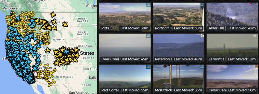
The Oregon Hazards Lab has developed and operates a high-speed camera network that gives fire managers new ways to detect and track wildfires. Cameras are installed atop high peaks or even high-rise buildings with 360-degree views of the surrounding area. Each camera can zoom, rotate, and tilt, allowing users to monitor the landscape, smokes, fire behavior, and weather conditions in real-time, or review later through time-lapse footage. The Oregon camera network is integrated with those operated by collaborators including the University of Nevada in Reno and the University of California at San Diego, with dozens of cameras in Oregon and thousands in the Western states.
The Oregon Hazards Lab network at the University of Oregon has helped put together the largest public-facing camera system in the world.
Doug Toomey, the lab’s director, says, “The cameras are visible during the day, and you can see twenty to forty miles on a clear day. At night they go near infrared, and you can actually see much farther.”
He told KEZI that detecting smoke on the cameras is only the first step. “There’s an operations center where they’re alerted when this camera spots something.”
There are currently 45 wildfire cameras in Oregon, and the Lab plans to operate 75 across the state by late 2025. These cameras help fire managers:
Detect, locate, and confirm ignitions
Quickly scale resources up or down
Monitor fire behavior from ignition to containment
Improve local evacuations and situational awareness
The increased situational awareness available with the cameras means fire managers can confirm 911 calls by reviewing camera footage instead of dispatching personnel or aircraft for reconnaissance. Not only is this safer and less expensive, but it frees up resources that may be needed elsewhere. Fire managers can also monitor prescribed fires, and utility companies can monitor their resources during red flag conditions.
Diane Braun, a former hotshot, said she thinks the cameras would have been a valuable resource when she was on the fireline. “It would have changed the industry,” she says, “from start to finish.” Toomey adds that the cameras play a role before a fire even starts; he says the cameras help to evaluate fuels and weather conditions in the area, including winds, humidity, and other factors before fire crews even arrive.
ALERTWest cameras live feed
The network lets people monitor cameras online. Toomey said he thinks the system can help people watch fire conditions and understand the threats — and even take steps in wildfire prevention. Agencies including the Oregon Department of Forestry have access to the camera system. Jessica Neujahr with ODF said using the cameras helps them not only detect smoke, but also dispatch resources faster and get a preview of the landscape they’re heading into.
==> WATCH LIVE CAMERA FEEDS HERE <==
The detection cameras are powered by ALERTWest, a technology platform from DigitalPath. This platform uses artificial intelligence to enable rapid wildfire detection. AI technology pulls the camera feeds from cloud servers and scans images for ignitions using detection algorithms and then can alert dispatch centers. Dispatchers then confirm the detection before alerting responding agencies. Fire managers in Oregon will begin receiving the automated alerts during the 2024 season.