Texas firefighters need fire department shirts

This message was distributed by Firefighter Close Calls August 30, requesting that it be passed along. If every fire station could send one shirt, that could have an impact.

****
All,
This is a immediate request for unused fire/rescue/EMS department or company t-shirts of any and all sizes to be distributed to Texas Firefighters (and their families) who have suffered property losses. The shirts will provide them with something new to wear after losing so much, and it also allows them to wear the logo of those departments, locals, associations and fire companies that were able to help.

If your fire department, EMS or rescue squad, association or local is able to help, by sending some of YOUR DEPARTMENT T-SHIRTS, please send them to:

Fire Shirts
c/o Texas State Fire Marshals Office
333 Guadalupe Street
Austin, TX 78701

The t-shirts will be provided specifically to firefighters, EMT’s and medics who have suffered losses over the last few days. This is the same that was done for Firefighters impacted by Katrina and it was very helpful and appreciated.

Take Care. be Careful. Pass It On.

BillyG
The Secret List 8/30/2017-1730 Hours
www.FireFighterCloseCalls.com

Satellite photo, wildfires in the Northwest U.S.

Click on the photo a couple of times to see a larger version.

Two wildfires in Washington were very active Tuesday

The Diamond Creek Fire burned across the international border into Canada Tuesday.

Above: Satellite photo showing smoke from fires in the Northwest United States August 29, 2017. The red dots represent heat detected at 3:56 a.m. PDT August 30, 2017.

(Originally published at 8:30 a.m. PDT August 30, 2017)

The Diamond Creek and Norse Peak Fires in Washington were very active Tuesday.

The Diamond Creek Fire in northern Washington that has been burning for five weeks spread across the border into Canada Tuesday. A spokesperson for the fire, Connie Mehmal, said it added another 16,000 acres to bring the size up to almost 49,000 acres, but heavy smoke on the north side in Canada prevented accurate mapping. The fire is not being completely suppressed, but special emphasis is directed toward protecting structures, including the community of Mazama on the south side.

Assigned to the fire are 3 helicopters and 3 fire engines for a total of 53 personnel, Ms. Mehmal said.

Diamond Creek Road
Firefighters on the Diamond Creek Fire chip debris along Ortell Creek Road, August 27, 2017.

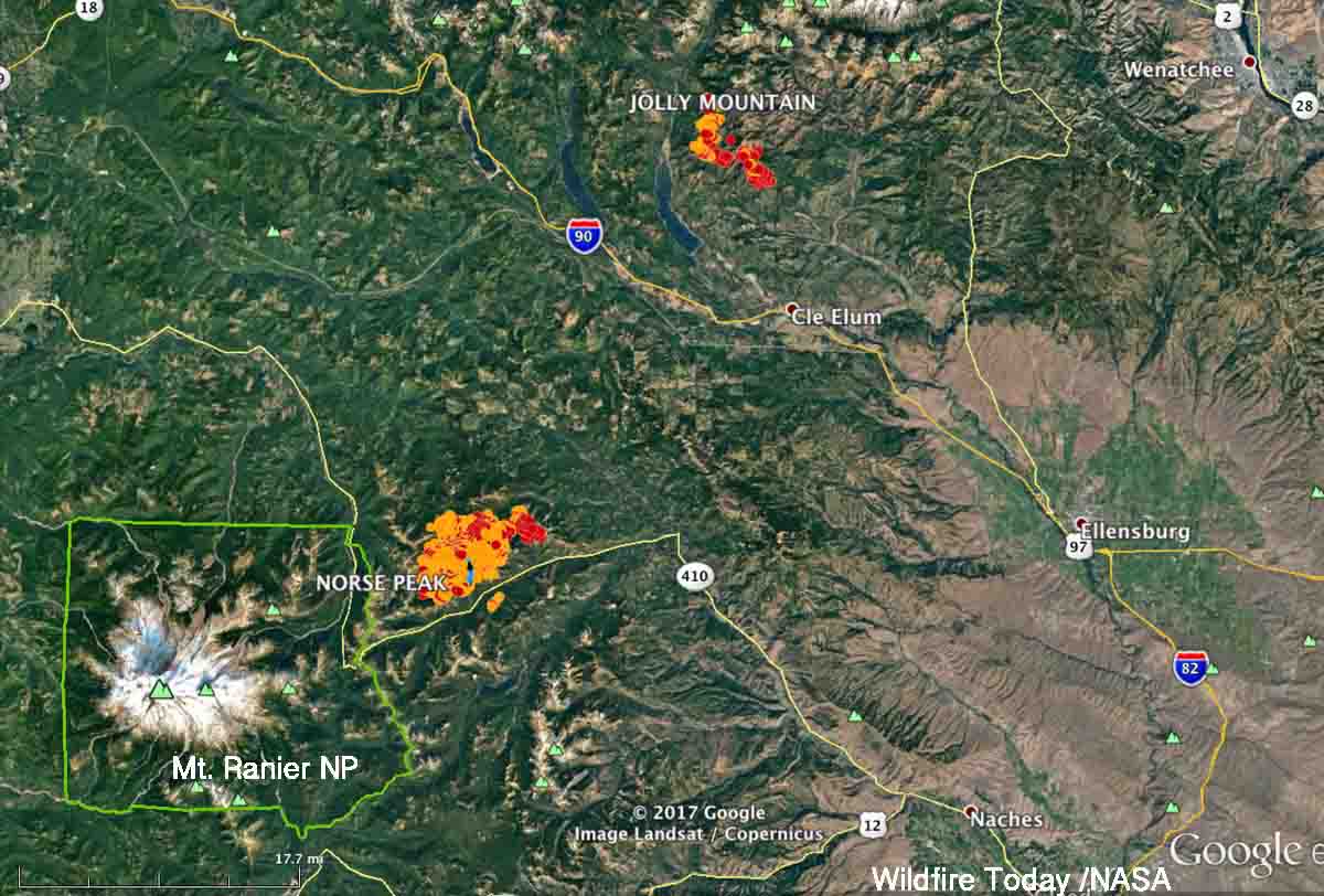
The Norse Peak Fire on the north side of Highway 410 northeast of Mount Rainier National Park grew by more than 9,000 acres Tuesday and has now burned 12,904 acres. Most of the spread was on the north side, pushed by a strong wind out of the south. The fire behavior on Monday and Tuesday was described as “plume dominated” and “extreme running, group torching, and short-range spotting”.

Norse Peak Jolly Mountain fires
Norse Peak and Jolly Mountain Fires, showing heat detected as late as 3:56 a.m. PDT August 30, 2017. The red areas are the most recent.

The strategy on the Norse Peak fire is not to completely suppress it, but to herd it around as necessary to protect private property and structures.

Rice Ridge Fire forces evacuations at Seeley Lake, Montana

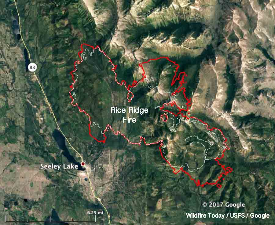
Above: A 3-D map of the Rice Ridge Fire, looking northeast. The red line was the perimeter at 10:30 p.m. MDT August 28, 2017. The white line was the perimeter two days earlier

(Originally published at 9:37 a.m. MDT August 29, 2017)

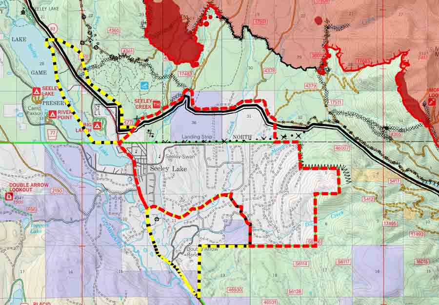
The Rice Ridge Fire made an unexpected southerly surge Monday evening toward the community of Seeley Lake after the wind direction shifted from the south and southwest to come out of the north and northwest. At about 7 p.m. Monday fire officials issued a mandatory evacuation order and three hours later expanded the area to include much of the community.

evacuation map rice ridge fire
Screen grab from a portion of the incident management team map of the Rice Ridge Fire dated August 29, 2017. The red dashed line is labeled “evacuation” while the yellow dashed line is “warning”. The solid red area was the fire at 10:30 p.m. MDT August 28. For the most current evacuation information go to Inciweb.

When the fire was mapped by a fixed wing aircraft at 10:30 p.m. Monday the Rice Ridge Fire had approached to within 1.5 miles of the Seeley Lake Community after a large finger of fire spread from the western flank. Sunday evening the incident management team had written in their evening update:

Containment is up to 22% as crews completed fire line along the west flank of the fire. Firefighters successfully completed small firing operations along the west and southwest edge of the fire that will aid in securing fire line.

The term “contain” or containment percentage means a fire line has been established along a portion of the perimeter. It does not mean the fire is “controlled” or “out”.  A 2-foot wide or 100-foot wide fireline is not guaranteed to stop the fire at that point. Strong winds have been known to blow burning embers and start new spot fires more than a mile away. The incident management team appears to be computing the containment percentage the way it should be done — showing the percentage of the fire perimeter where a fireline is completed and the spread is at least temporarily halted. The fire could continue to spread across the fireline, but it is not thought likely. The unexpected wind shift may have been the unlikely occurrence in this case.  The definition of these and hundreds of other fire management terms are in the National Wildfire Coordinating Group Glossary.

map rice ridge fire
Map of the Rice Ridge Fire. The red line was the perimeter at 10:30 p.m. MDT August 28, 2017. The white line was the perimeter two days earlier

An incursion into the air space over the fire by a drone shut down all firefighting aircraft Sunday evening.

Seeley Lake is closed so that firefighting aircraft can safely access the lake to refill their water buckets or tanks.

The incident management team is not releasing a great deal of information about the fire. It has been almost two weeks since photos were posted on their Inciweb page.