Wildfire potential — August through November

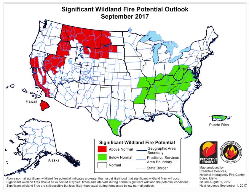
The prediction for August shows enhanced fire potential for the Northern Rockies, Northern Nevada, and much of California and the Northwest.

On August 1 the Predictive Services section at the National Interagency Fire Center issued their Wildland Fire Potential Outlook for August through November. The data represents the cumulative forecasts of the ten Geographic Area Predictive Services Units and the National Predictive Services Unit.

It revises the outlook that was issued for August a month ago, adding to the “Above Normal” category Northern Idaho, the eastern halves of Oregon and Washington, and Western Montana. Many of the August “Above Normal” areas will carry over into September except for the areas in Oregon and Washington.

Below are:

  • the highlights of the NIFC report;
  • NIFC’s graphical outlooks for September through November;
  • Drought Monitor, and;
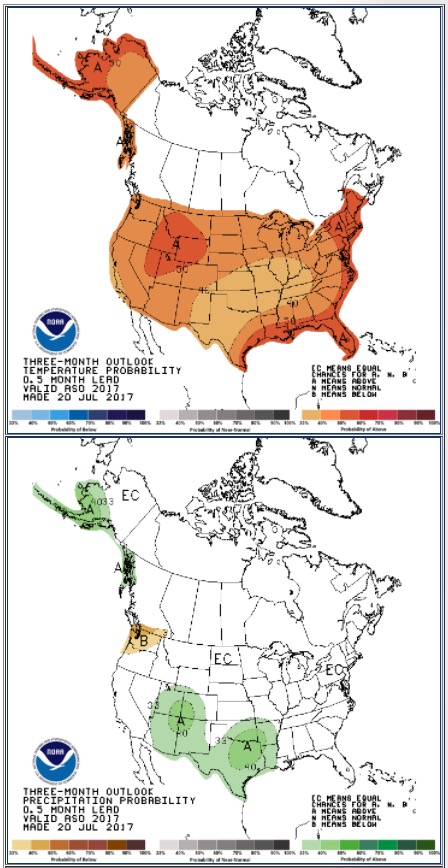
  • NOAA’s long range temperature and precipitation forecasts.

****

The seasonal transition of the western fire season north has occurred. A strong southwestern monsoon has developed over the Southwest and has reduced the significant large fire potential and activity across the Four Corners Region. Significant lightning activity associated with the monsoon has spread north creating numerous incidents across the northern Great Basin, Northern California, Pacific Northwest, and the Northern Rockies. With the fine fuels now fully cured and with larger fuels now receptive, even at the higher elevations, fire activity is increasing as it nears its seasonal peak in August. While the northwestern states have shown a significant upturn in activity, fire activity in Alaska has begun to wane with the arrival of the late summer rains across the Alaskan Interior. The eastern and southeastern states have seen and will continue to experience overall limited activity as the regions remain largely out of season.

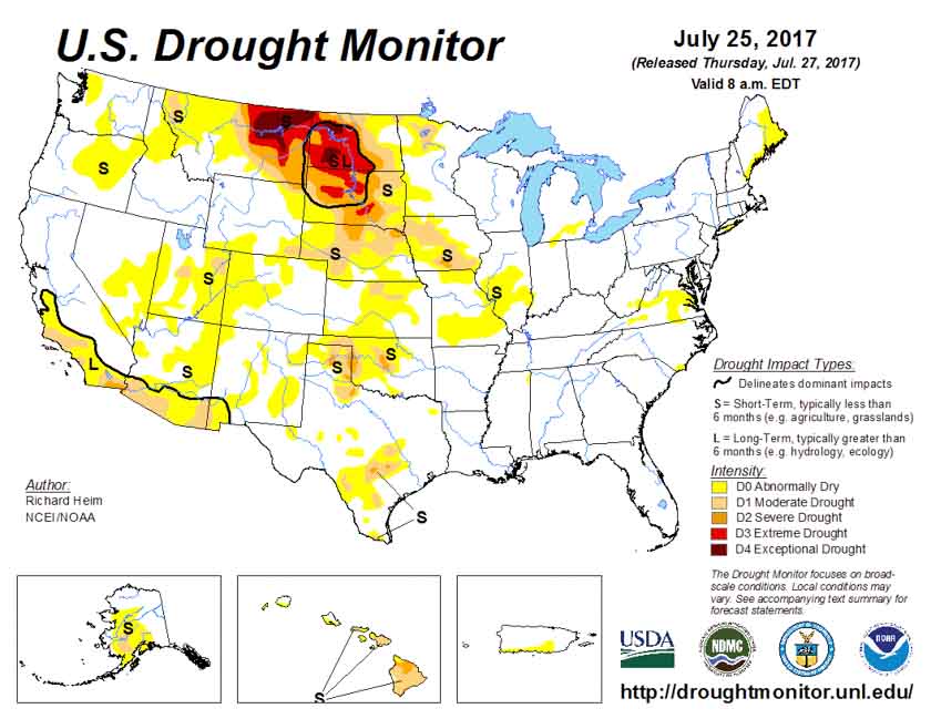
Precipitation received was generally well below average across the western half of the country in July. With the occurrence of three significant heat wave events, fuels dried quickly and became receptive to fire earlier than in most years. By month’s end, the previous winter’s record snowpack and above average spring rainfall was a distant memory. Drought was beginning to reemerge in the Rockies and across portions of the Pacific Northwest. Across the northern Great Plains, the established long term drought conditions continued to worsen. Large fire activity became problematic across eastern Montana, Wyoming and the Dakotas.

Looking forward to the peak of the western fire season in August and September, conditions are expected to remain favorable for the Above Normal significant fire activity to continue. Areas with the greatest potential for significant large fire activity will be the grasses and rangelands of the Pacific Northwest east of the Cascades, the lower and middle elevations across California, most of the Northern Rockies region. The grass and rangelands across the northern Great Basin will also continue to demonstrate Above Normal significant large fire potential and activity.

****

September wildfire potential

October November wildfire potential

****

drought monitor

****

90 day outlook weather

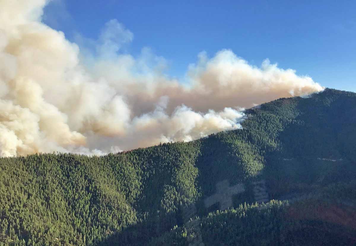
Elephant Hill Fire in British Columbia grows to 194,000 acres

The fire has been burning near Cache Creek, BC since July 6, 2017.

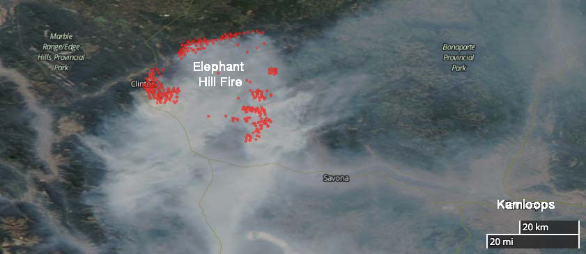
Above: Satellite photo showing the location wildfires in British Columbia and Alberta, July 31, 2017. The red dots represent heat detected by the satellite.

(Originally published at 7:32 p.m. MDT July 31, 2017)

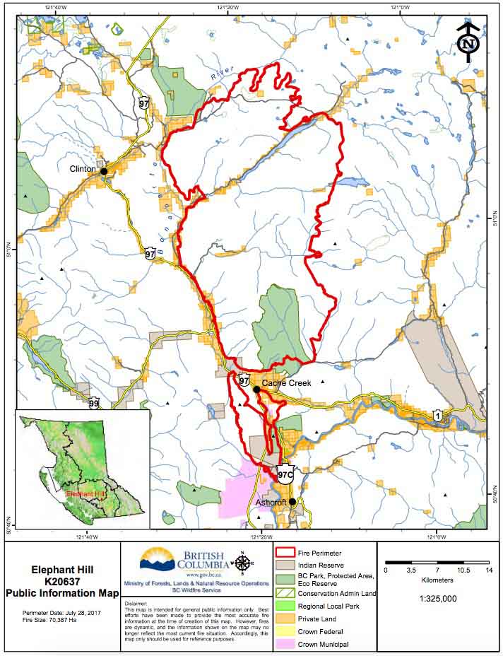
Currently there are many wildfires burning in British Columbia and Alberta. One of them is a megafire just east of Clinton, north and south of Cache Creek, and about 50 miles northwest of Kamloops. I’m not sure if it’s the Mother of All Fires, for this year anyway, but so far it has covered 78,548 hectares (194,096 acres). The BC Wildfire Service says that number is probably low, since the visibility has prevented them from conducting mapping flights for a day or two.

(More recent information about the Elephant Hill Fire and other fires in British Columbia was posted August 2, 2017.)

The recent warmer and drier weather has contributed to increased growth in recent days. On Sunday most of the spread was on the north and west sides.  The objective on the west flank is to remove excess fuel ahead of the fire, keep it south of the Bonaparte River, and slow the aggressive fire behavior. Night shift crews are working from 8 p.m. to 8 a.m. to reinforce firelines.

Structure protection personnel, engines, and equipment are assigned 24 hours a day. They are working across the fire to conduct property assessments, establish sprinkler systems on structures, and protect values where needed.

Elephant Hill Fire map
Satellite photo showing smoke on the Elephant Hill Fire northwest of Kamloops, July 31, 2017. The red dots represent heat detected by the satellite.

The community of Clinton and areas to the northeast including Green Lake have been evacuated.

Resources assigned to the fire include 20 helicopters and 69 pieces of heavy equipment for a total of 359 firefighters.

The map below was current July 28, 2017.

Elephant fire map

Another community evacuated near Sunrise Fire in western Montana

Above: 3-D map of the Sunrise Fire looking west. The red line was the perimeter at 9 p.m. MDT July 30, 2017. The white line was the perimeter two days earlier.

(Originally published at 5:55 p.m. July 31, 2017.)

During the last two days the Sunrise Fire west of Missoula, Montana 6 miles south of Riverbend has continued to work its way down the slopes near the small communities west of the Clark Fork River, moving to within 1.5 to 0.3 miles of the river. As of Sunday night it had burned about 8,200 acres, an increase of 2,700 acres in the last two days.

Another community, Verde Creek, has been added to the evacuation orders that already included Sunrise, Quartz Flats, and Quartz Creek.

The areas of major growth on Saturday and Sunday were on the north and southeast sides.

Sunrise Fire
The Sunrise Fire, July 30, 2017. Photo by Kevin Chaffe.

On the south side, the fire continued to burn into the Quartz Creek drainage; retardant was used to slow its spread downslope. On the north side in Sunrise Creek, the fire made an aggressive uphill run towards Eagle Rock and Verde Saddles.

Hotshot crews conducted controlled burning operations to reduce fuels in the Sunrise and Quartz Flats Communities while helicopters and air tankers were busy on all areas of the fire.

Resources assigned include 14 hand crews, 6 helicopters, 31 engines, 5 dozers, 14 water tenders, 4 skidgens, and 1 masticator for a total of 494 personnel.

All articles about the Sunrise Fire can be found HERE, with the most recent at the top of the page.

Wildfires in Modoc County, California add another 11,000 acres

The Modoc July Complex of fires in northeast California has now covered 50,916 acres.

Above: Cove Fire, July 29, 2017. Uncredited photo on Inciweb.

(Originally published at 11:28 a.m. PDT July 31, 2017)

Two of the wildfires in the Modoc July Complex of fires in northeast California were very active Sunday, adding a combined 11,293 acres to bring the total burned area to 50,916 acres.

The Type 2 Incident Management Team transitioned to a Type 1 Team Monday morning, so we are in the usual dead zone for up to date fire information — yesterday was a time when the previous team does not want to step on the toes of the incoming team and today the new team is still getting their feet on the ground. This transition period can also be a time of heightened danger for firefighters out on the fire.

But the new team provided some additional information after 11 a.m. today, Monday.

map cove fire
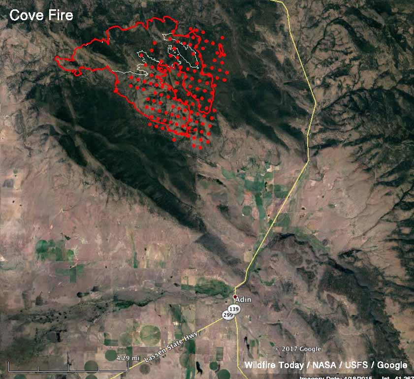
Map of the Cove Fire in Modoc County, California. The red line was the perimeter at 11:30 p.m. PDT July 30. The white line was the perimeter 24 hours before. The red dots represent heat detected by a satellite at 3:19 a.m. PDT July 31, 2017.

But we do know, thanks to overflights of the fires by a satellite and fixed wing aircraft, that the Cove Fire spread aggressively to the east and southeast. It is now about five miles northwest of Adin, a town that had 272 residents in the 2010 census.

Conditions Sunday along the southern edge permitted tactical firing operations from the 40N14 Road to the 40N09 Road to aid in securing the southern edge of the fire. Firefighters also conducted firing operations from the 40N14 Road to the 40N12 Road to strengthen firelines. The northern fireline held overnight with no additional fire spread.

Modoc July Complex of fires california
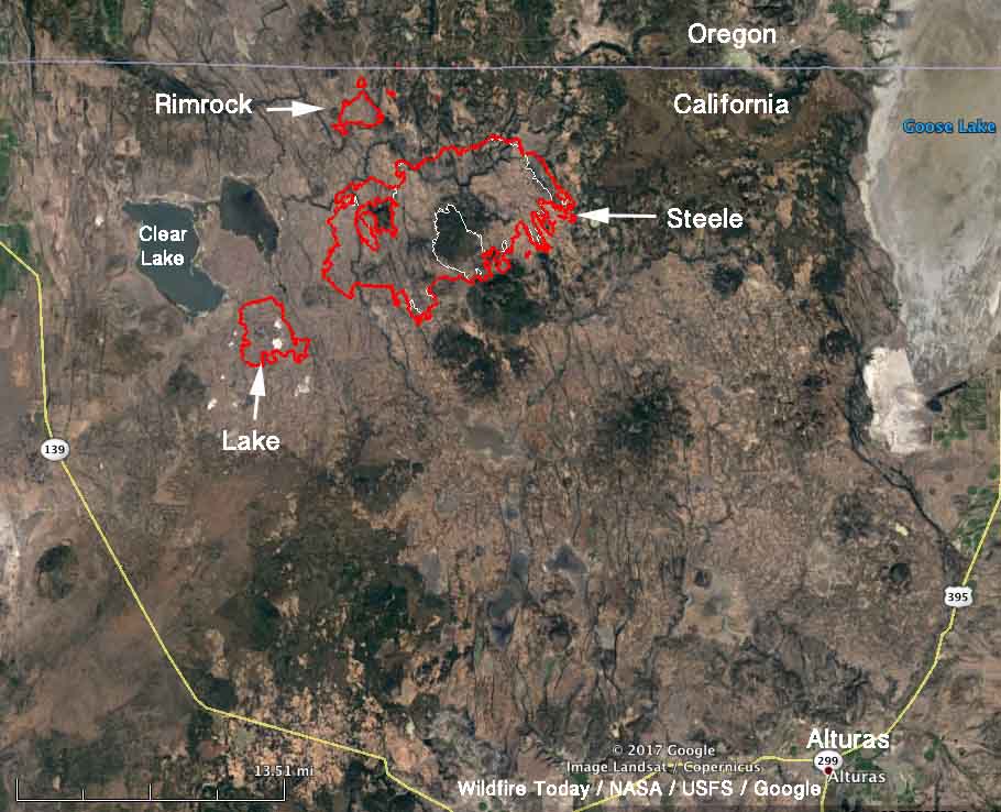
Map of the fires in the north portion of the Modoc July Complex of fires in Modoc County, California. The red line was the perimeter at 11:30 p.m. PDT July 30. The white line was the perimeter 24 hours before.

The other active fire in the Complex was the Steele Fire which also grew on the southeast side but did not spread as much as the Cove Fire farther south. Northeast winds pushed the fire across the 136 Road to the south in an additional location. Crews and dozers contained the 40-acre slopover and by Monday morning had mopped up 50 feet inside the line.

There has been very little growth on the Lake and Rimrock fires.

The weather forecast for Monday through Thursday for Canby, north of the Cove Fire, calls for temperatures around 100 with relative humidities about 10 percent. The wind, at 2 to 6 mph, will be from variable directions during the period. An Excessive Heat Warning is in effect for Tuesday through Thursday.

All of the articles about the Modoc July Complex of fires can be found here, with the most recent at the top. 

Sky lantern sets fire to Olympic venue in Rio

The track and roof of the velodrome used in the 2016 Olympics in Rio de Janeiro were damaged after a sky lantern landed on the facility. Much of the roof was heavily damaged and photos from TV network Globo showed a 20 to 30 meter section of the track had burned. Wood from Siberia was used to construct the track surface which made it one of the last venues in the Rio Olympics to be ready.

Sky lanterns, also known as Chinese lanterns, are plastic or paper bags lofted by the heat created by burning fuel at the bottom. After they are launched the perpetrator has no control and the dangerous devices are carried wherever the wind blows. Too often they get caught on trees, roofs, cell phone towers, or land on the ground when the flames are still active and start damaging fires. They are banned in most U.S. states and many countries, including Brazil.

Some areas enact specific laws or regulations prohibiting sky lanterns, but they are banned in any state or city that adopts the 2015 edition of the International Fire Code.

Thanks and a tip of the hat go out to Andrew.
Typos or errors, report them HERE.