Two reports released on the same day about the escaped prescribed fire near Carson City, NV

Above: Map of the Little Valley Fire at 9:23 p.m. PDT October 14, 2016.

On February 15 two reports were released about the prescribed fire that escaped, burned 2,291 acres, and destroyed 23 homes northwest of Carson City, Nevada on October 14, 2016. The first report about what became the Little Valley Fire included the results of a months-long independent investigation by the Reno Gazette-Journal (RGJ). The other, released a few hours later, was the product of the official investigation requested by the Nevada Division of Forestry (NDF), the agency responsible for conducting the prescribed fire.

Hours before the fire escaped, all eleven firefighters that had been mopping up the prescribed fire left the project and returned to their stations between 1:30 p.m. and 4:45 p.m. on October 13, 2016. During that day there were a number of smokes that received the attention of the firefighters. During the last two hours before the seven-person helitack crew departed they noticed the wind increasing — trees were blowing down and branches were falling.

The RGJ reported on the reason the firefighters were ordered to leave the burn site.

Gene Phillips, NDF forest health specialist and burn boss for the Little Valley Burn, made the decision to pull crews from the burn site after discussing the high wind forecasts for the evening with a burn boss trainee, according to the review.

The decision not to staff the site on the evening of Oct. 13 was made, according to NDF, “based on the limited amount of heat near the control lines, success of the current mop-up effort, and the risk to firefighters working in timber during high winds.”
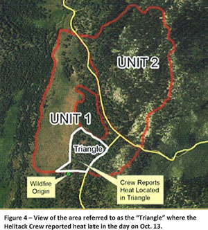
escaped fire map
From the NIMO report.

At 5:38 p.m. the Little Valley weather station recorded sustained winds out of the west at 15 mph with a maximum gust of 39 mph. By 12:38 a.m. on October 14, about the time the fire escaped, the wind was at 19 mph with gusts up to 87 mph. The relative humidity was 32 percent.

A Red Flag Warning for gusty winds and low humidity was in effect from the morning of October 11 through 5 p.m. on October 14. Strong winds persisted until mid-day on October 17.

The NDF’s report was written by the U.S. Forest Service’s Phoenix National Incident Management Organization (NIMO), a team that usually manages fires and other incidents that are often of longer duration than a typical wildfire. The team was supplemented with a Fire Behavior Analyst, a GIS/Fire Behavior Analyst, a Public Information Officer, a Fire Investigator, and others for a total of 10 personnel that were listed in the report.

The NIMO team concluded that the fire escaped when embers from a burning stump hole were blown 34 feet and crossed the fireline at a corner, or “dog leg” in the fire perimeter.

According to the RGJ there was confusion in initially responding to the fire after it escaped at around 12:38 a.m. on October 14:

Response to the fire was delayed, affecting how fast it could be contained: A call at 1:23 a.m. about smoke at the burn site was later dismissed as “unfounded,” causing a TMFPD [Truckee Meadows Fire Protection District] fire engine to return to the station three minutes after it left. After a second call about smoke at the burn site, it took TMFPD more than an hour to get to the site after crews were dispatched, according to 911 transcripts.

Interview with a lead plane pilot about the 747 Supertanker

This article first appeared on Fire Aviation.

On January 24, 2017 the 747 SuperTanker left its base in Colorado Springs, Colorado for an assignment in Chile. It returned on February 13 after dropping on many wildfires in the South American country, making as many as seven sorties in a day each with 19,200 gallons of water enhanced with an additive to help make the water more effective, since long term retardant was not available.

Jamie Tackman
Jamie Tackman

After 17 years as a ground based wildland firefighter, with much as it as a smokejumper, Jamie Tackman transitioned to the air, becoming a lead plane pilot. He has worked off and on with the 747 air tankers since Evergreen converted the first one. Now retired from the U.S. Forest Service, he traveled to Chile to provide lead plane services for the huge aircraft operated by Global SuperTankers. This time he had a different role, or at least a different platform, flying ahead of the air tanker as usual but in an aircraft flown by military pilots.

Bill Gabbert interviewed Jamie, who began by describing the situation. Chile has no infrastructure for supervising, using, or refilling large or very large air tankers and they were unfamiliar with the concept of lead planes. In spite of these challenges the personnel working with the 747 and the other aircraft developed procedures to fight the fires from the air, while the local firefighters improvised a system on the ground for refilling the 747 and the IL-76 with water.

Wildfire threatens Christchurch, New Zealand

Above: @Howesaman took this photo as she flew in to Christchurch from Wellington.

(UPDATED at 9:05 a.m. MST February 16, 2017)

The wildfire at Christchurch, New Zealand was slowed by light rain Thursday night and more precipitation is in the forecast for Friday.

Officials are reporting that 11 Christchurch homes and two outbuildings have been destroyed by the fire and 2,075 ha (5,127 acres) have burned.

Two fires burned together to become the large fire that spread to the suburbs of Christchurch. One was started by an electrical problem and the other originated at a car park. Officials are not speculating as to whether the causes are suspicious.

Approximately 400 homes have been evacuated affecting about 1,000 residents.

****

A large wildfire is burning in the suburbs of Christchurch, New Zealand in the Port Hills area. As of Wednesday morning U.S. time it had blackened 4,571 acres (1,850 Ha), destroyed an uncertain number of homes, and required the evacuation of approximately 1,000 residents.

On February 14 a helicopter pilot, David Steven Askin, was killed while working on the fire.

Below is an excerpt from an article at nzherald.co.nz:

Christchurch mayor Lianne Dalziel has told Newstalk ZB’s Mike Hosking that she was “very worried” for Christchurch.

“We’ve been going through what’s happened overnight, obviously there’s been more evacuations so we’re looking at 450 properties approximately that have been officially evacuated, with police doorknocking and the army in support as well, so it is very serious.”

She said people have been reporting seeing the fire very close to their properties near Port Hills.

“It looks as if up to seven properties have been affected by the fire, it’s difficult to say until light arrives to get a full handle on how many properties that have been destroyed.”

Dalziel said the blaze was a “difficult fire”.

“We had two seperate fires, one that started in the Selwyn district, managed as a significant rural fire, then fire erupted on the city side, ultimately the worst fears were realised and the two fires came together yesterday.

“It is close to areas of population.”

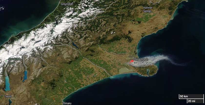
Christchurch Fire map
The red dots on the map of the Christchurch area represent heat detected by a satellite February 15, 2017 U.S. time. Smoke can be seen blowing off toward the east. NASA.

The weather forecast for Christchurch on Thursday (Wednesday U.S. time) predicts cooler temperatures in the high 60s F, relative humidity in the high 40s, and winds out of the east-northeast at 3 to 6 mph in the morning increasing to 16 mph in the afternoon.

In 2011 an earthquake centered 6 miles southeast of Christchurch caused widespread damage in the city and killed 185 people.

Idaho legislature refuses to close loophole in fireworks regulations

The state of Idaho has a ridiculous law regulating the use of fireworks. It prohibits the use of fireworks that fly more than 20 feet into the air, including bottle rockets and aerial displays, that are used for private purposes. However, they can be sold in the state without any problem. The buyer simply has to promise by signing a form that they will not use them in Idaho.

Yesterday House Minority Leader Rep. Mat Erpelding introduced legislation that would close this loophole, making the sale of the illegal fireworks illegal. However within hours on a vote of 9 to 6 it was shot down by the House State Affairs Committee.

Dennis Doan, Chief of the Boise Fire Department, released a statement on Monday:

I would like to thank Rep Erpelding for his leadership on this issue. It was clear by the actions of the committee today they do not care about firefighter safety, or if people’s homes and lives are being destroyed by illegal fireworks every year. The exorbitant cost to taxpayers and local governments, and the fact that six homes in Ada County were burned down last year, was not enough to influence their decision to print a bill which would allow a full hearing and dialogue about this important issue.

The ability to purchase illegal fireworks apparently trumps the right of residents to protect their home from fires. This summer when someone’s home burns down due to aerial fireworks you can blame the House State Affairs Committee.

The 2,500-acre Table Rock Fire in the Boise foothills last June was caused by illegal fireworks, burned a home, and cost taxpayers $341,000, according to Chief Doan.

Arson in the snow

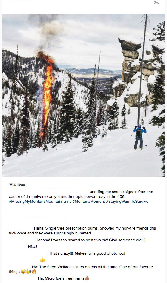
arson in snow
(The instagram names of individuals were removed from the image.)

This is a screen grab of an Instagram photo posted approximately two weeks before today, February 13, 2017.  “406” probably refers to Montana’s area code.

I didn’t know this was a thing. If that is on public land…wrong on so many levels.

Wildfires in Colorado while fire weather warnings affect 7 states

Above: Red Flag Warnings and Fire Weather Watches affect seven states, February 10, 2017.

(UPDATED at 2:57 p.m. MT February 10, 2017)

Evacuations, earlier mostly lifted, have been reinstated for the wildfire west of Longmont, now named the Rogers Fire.

The name of the fire northwest of Boulder is Wagon Wheel Gap Fire.

****

Originally published at 10:07 a.m. MT February 10, 2017.

While Red Flag Warnings and Fire Weather Warnings are in effect in seven states, two fires erupted early Friday morning just outside the warning area in Boulder and Longmont, Colorado.

Before 7 a.m. a grass fire started near the 5000 block of Nelson Road west of Longmont that forced the evacuation of 125 homes. It burned two barns and a haystack before firefighters stopped it at 15 acres.

Just after 8 a.m. a second fire broke out northwest of Boulder near the intersection of Lee Hill Drive and Wagon Wheel Gap Road that required the evacuation of 157 homes. At the last report at 9:10 a.m. it had burned three to five acres.

There is no indication so far that the two fires, 12 miles apart, are related.

The video below shows the fire near Boulder burning in steep terrain.

Strong winds that pushed the fires have also toppled semi-trucks across the state and left 3,960 customers without power in Boulder County.

It is unusual to have wildland fires burn structures and require evacuations only an hour or two after sunrise in mid February. Much of the front range in Colorado has had less snow than usual. When I drove through the area a few days ago there was virtually no snow on the ground near Colorado Springs, Longmont, and Denver, and these are areas above 5,000 feet.

Most of the Red Flag Warnings were issued around 5 a.m. on Friday and will expire at 5 to 6 p.m. local time today, depending on the area.

map fires longmont boulder
Map showing the location of fires near Boulder and Longmont, Colorado.