Scientists hope data collected at prescribed fire will help develop better technologies to detect and monitor fires

Sage multichannel sensing during prescribed fire
Argonne scientists monitor a controlled burn on the Konza prairie in Kansas using the Sage monitoring system. (Image by Rajesh Sankaran/Argonne National Laboratory.)

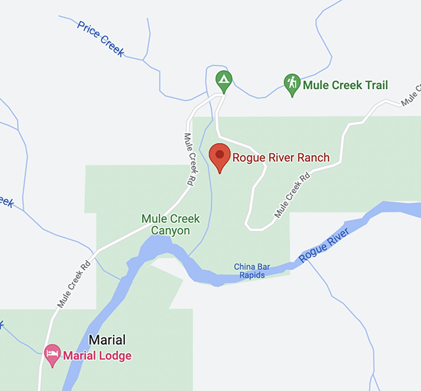
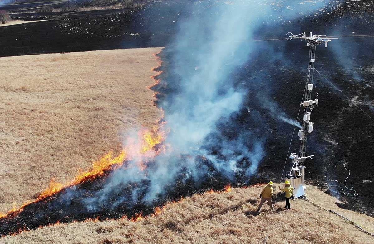
Scientists recently deployed a complex array of sensors during a prescribed fire at the Konza tallgrass prairie in Kansas to collect a vast trove of data. It was immediately processed at the site using advanced computing technologies provided by a new platform called Sage.

Sage offers a one-of-a-kind combination that involves multiple types of sensors with computing ​at the edge”, as well as embedded machine learning algorithms that enable scientists to process the enormous amounts of data generated in the field without having to transfer it all back to the laboratory. Computing ​at the edge” means that data is processed where it is collected, in the field, while machine learning algorithms are computer programs that train themselves how to recognize patterns.

Sage is funded by the National Science Foundation and developed by the Northwestern-Argonne Institute for Science and Engineering (NAISE), a partnership between Northwestern University and the U.S. Department of Energy’s Argonne National Laboratory.

Equipment used to monitor a controlled burn on the Konza prairie in Kansas using the Sage monitoring system. (Image by Rajesh Sankaran/Argonne National Laboratory.)

The advanced cyberinfrastructure deployed in Sage, which allows for on-the-spot detection, monitoring, and analysis of the burned area, could offer scientists and natural resources officials the ability to get ahead of forest fires with quickly analyzed, multi-instrumented data.

When it comes to forest fires, time is absolutely of the essence,” said Argonne computational scientist and NAISE Fellow Rajesh (Raj) Sankaran. ​Often, there’s no time to move data from the field — where high-speed connectivity might be an issue — to the lab. With Sage, we’re getting the pertinent information we need when we need it.”

The prescribed fire in the Konza prairie gave the researchers a large collection of data — almost 60 DVDs worth — full of information about the progression of smoke and fire. This data can be used to educate a machine learning algorithm that can make further determinations of the behavior of other fires in real time.

After the success of the Sage network in Kansas, future plans exist for the network to be deployed in California, Colorado, Illinois, and Texas as part of a network led by the National Ecological Observatory Network (NEON). Eventually, researchers hope to establish a continent-spanning network of smart sensors that could employ Sage technology. ​

NEON is developing a mobile deployment platform that can complement land-based and aquatic sites all over the country,” Sankaran said. ​Sage can play a supportive role in many different environments throughout the United States.”

CNN covers legislation that would increase pay for federal wildland firefighters

Updated at 9:20 a.m. EDT July 31, 2022

The House of Representatives narrowly passed the legislation Friday. Now it goes to the Senate.


12:46 EDT, July 27, 2022

Wildfire Response and Drought Resiliency Act
Rep. Joe Neguse interviewed on CNN July 27, 2022 about the Wildfire Response and Drought Resiliency Act.

In this video from CNN, Brianna Keilar interviews Colorado Rep. Joe Neguse about the Wildfire Response and Drought Resiliency Act, H.R. 5118, which would benefit wildland firefighters. It boosts their pay and benefits, helps the Forest Service fill gaps in fire management staff, and promotes bigger forest management projects to reduce hazardous fuels.

The bill is a conglomeration of half a dozen pieces of legislation,  including the Tim Hart Wildland Firefighter Pay Parity Act (H.R. 5631), all rolled into one. It would require that the minimum basic pay for any Federal wildland firefighter position be no less than the pay for a GS-6 Step 3, which is $42,946 a year ($21.29 an hour).  It would also stipulate that the salary be adjusted annually by not less than the change in the Consumer Price Index.

Suspected arsonist captured and tied to tree by locals

Updated at 12:06 p.m. PDT July 27, 2022

mapJ uly 25 arson fires in Southwest Oregon
General area of the July 25 arson fires in Southwest Oregon.

On Monday a Bureau of Land Management employee reported that a man was walking down a road igniting vegetation fires in a remote area about 25 miles northwest of Grants Pass, Oregon.

From the AP:

Ground crews, assisted by local residents, and three helicopters quickly got the two fires under control, Curry County Sheriff John Ward said.

Meanwhile, three local residents located the suspect walking on the road near the fires and detained him.

“It was reported that the suspect became very combative with the three residents and had to be tied to a tree to subdue him.,” Ward said in a statement. “An ambulance crew was asked to respond due to some injuries that the suspect apparently received from falling down.”

Smith was transported to Three Rivers Hospital in Grants Pass and once he was medically cleared, transported by US Forest Service law enforcement to the Curry County Jail and held on Reckless Burning and two counts of First-Degree Arson. There was also a Detention Warrant in effect out of Lane County for probation violation.

Trennon Ray Smith mug shot
Trennon Ray Smith. Lane County Sheriff’s Office.

Forest Service withdraws decision about 50,566-acre fuel treatment project in New Mexico

Planned on the Santa Fe National Forest

The U.S. Forest Service announced Tuesday that they are withdrawing the draft Decision Notice and Finding of No Significant Impact issued in March for the 50,566-acre Santa Fe Mountains Landscape Resiliency Project. It would involve prescribed fire and vegetation thinning treatments on 36,680 acres east of Santa Fe, New Mexico on a landscape scale. Each year at least 750 acres would have been thinned and up to 4,000 acres would have been treated with prescribed fire during a 15- to 20-year time frame.

Map Santa Fe Mountains Landscape Resiliency Project
Map of the Santa Fe Mountains Landscape Resiliency Project.

On July 12 the Board of County Commissioners of Santa Fe County passed a resolution urging the FS to conduct a full Environmental Impact Statement (EIS) for a planned very large fuel management project. The FS went through the much less complicated Environmental Assessment (EA) process, which included the draft EA, public outreach, and accepting comments, then issued a Finding of No Significant Impact (FONSI) which they felt enabled the implementation of the project.

The statement issued by the Santa Fe National Forest dated July 26, 2022 said, “The SFNF is taking this step to reengage with our partners and community on this very important project to improve forest health in and around Santa Fe…Our intent is to reinitiate the decision and NEPA process for this project after the Chiefs 90-day pause with the publication of a legal notice in the Albuquerque Journal, the newspaper of record. If you previously submitted an objection to the final environmental assessment and draft notice of decision, you will need to resubmit your objection at that time.”

After three prescribed burning projects on the Santa Fe National Forest got out of control since 2018 and had to be converted to wildfires, some of the locals are worried about future projects on the forest.

The current 341,735-acre Calf Canyon / Hermits Peak Fire is the result of two prescribed fires that escaped control earlier this year on the Santa Fe National Forest. One was a broadcast burn that crossed control lines during strong winds. The other originated from slash piles that were ignited in late January that continued burning for months. In mid-April one or more of those piles became very active during strong winds and merged with the other escaped fire on April 22. The fire has destroyed at least 400 homes, forced up to 18,000 people to evacuate their properties, resulted in flooding, and cost more than $248 million in firefighting expenses.

In 2018 another pile burning project on the Santa Fe escaped months after it was ignited and had to be converted to a wildfire. A Facilitated Learning Analysis found that “communication” and “prescribed fire preparation and risk” were common themes.

The notice from the FS is below.

[pdf-embedder url=”https://wildfiretoday.com/wp-content/uploads/2022/07/USFS_withdraws_Decision_Notice.pdf” title=”USFS withdraws Decision Notice Santa Fe National Forest”]


The USFS documents regarding the project can be found here.

Moose Fire grows to 37,264 acres

Northwest of Salmon, Idaho

Moose Fire map 10:18 p.m. MDT July 25, 2022
Moose Fire map. The red line was the perimeter at 10:18 p.m. MDT July 25, 2022. The white line was the perimeter about 48 hours before. The brown areas had extreme heat when the fire was mapped.

Most of the growth on the Salmon Fire 10 miles northwest of Salmon, Idaho has been south of the Salmon River in recent days. It was mapped Monday night at 37,264 acres, a 24-hour growth of more than 1,500 acres.

On the east side, fire activity was high in Bobcat Gulch and the Napoleon Hill area in the late afternoon Monday and through the night. Spot fires occurred one mile south of Napoleon Hill as the fire was pushed by winds out of the north. The south side of the fire generally is holding in place with no new growth in the Moose Creek area. The fire is still spreading on the west side south of the river.

On the south side where the strategy is to “confine”, not “contain”, heavy equipment task forces are constructing and reinforcing indirect fire line six to nine miles south of the fire from Morning Glory west to Leesburg, and further west into Panther Creek, then to the Salmon River.

One of these indirect firelines being constructed is five miles south of the southeast corner of the fire, south of Moose Creek Road.

The photos below were taken July 23 by Mike McMillan for the US Forest Service.

Moose Fire Salmon Idaho
Firefighters on the Moose Fire prepare to defend structures along Hwy 93 corridor, July 23, 2022. Photo by Mike McMillan-USFS
Moose Fire Salmon Idaho
Firefighters on the Moose Fire, July 23, 2022. Photo by Mike McMillan-USFS
Moose Fire Salmon Idaho
Moose Fire backs down a slope, July 23, 2022. Photo by Mike McMillan-USFS


Oak Fire slows, but still spreads into footprint of 2018 Ferguson Fire

CAL FIRE is using one of their new Firehawk helicopters to drop water at night

 7:05 a.m. PDT July 26, 2022

Oak Fire map 7:27 p.m. July 25, 2022
Oak Fire map. The red line was the perimeter at 7:27 p.m. July 25, 2022. The white line was the perimeter about 23 hours before.

Fire officials called Monday a successful day on the Oak Fire northwest of Mariposa, California, saying there was minimal growth. The 1,200 acres added paled in comparison to the rapid spread seen on Friday and Saturday. It was mapped Monday night at 18,017 acres, with most of the increase being on the east side where it is chewing through the four-year old vegetation in the footprint of the 2018 Ferguson Fire. East of Jerseydale it has advanced nearly two miles into the fire scar.

To see all articles on Wildfire Today about the Oak Fire, including the most recent, click HERE.

Helicopters dropped 300,000 gallons of water Monday, including thousands of gallons dropped by one of CAL FIRE’s new night-flying helicopters, H-903, normally based at McClellan near Sacramento. According to tracking data recorded by FlightAware it conducted what appeared to be two fuel cycles working out of the Columbia airport 42 miles northwest of the Oak Fire. Until CAL FIRE recently purchased their 12 new Sikorsky S-70i Firehawk helicopters they were not in the night-flying business. This was one of the first fires CAL FIRE has flown at night.

CAL FIRE H-903, Sikorsky S-70i FireHawk
CAL FIRE H-903, Sikorsky S-70i FireHawk, N483DF, Photo by Dylan Phelps, Sept. 2020.

The damage assessment team has been working for the last two days to identify structures affected by the fire. Monday afternoon their findings to date were released — 21 residences and 34 outbuildings have been destroyed.

Resources on the incident Monday night included 24 helicopters, 302 fire engines, 82 dozers, 68 water tenders, and 61 hand crews for a total of 2,991 personnel.