Alberta fires evacuate thousands

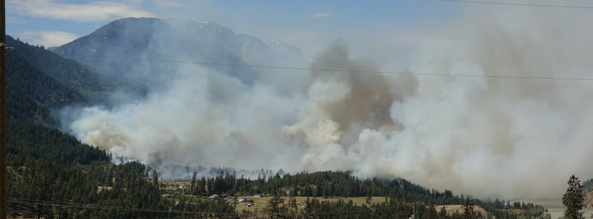
UPDATE 05/06/2023:   Three wildfires burning near the boundary between British Columbia and Alberta have forced evacuation orders and an alert. Two of the fires are in the Peace River region, including the Red Creek Fire, covering 1,550 hectares (3,830 acres) northwest of Fort St. John, B.C., about 1,200 kilometres (745 miles) northeast of Vancouver.

CBC Canada reported that the evacuation order covers 61 homes in the area; Goodlow, B.C., and the surrounding region are also under evacuation orders ahead of the Boundary Lake Fire, which covers an area of 19 square kilometres (~4700 acres).

 Boundary Lake Fire in the Prince George Fire Centre. (B.C. Wildfire Service)
 Boundary Lake Fire in the Prince George Fire Centre. (B.C. Wildfire Service)

Dozens of new wildfires were discovered across Alberta on Thursday amid high temperatures, dangerously dry conditions, and high winds. More than 10,000 people across Alberta are now affected by mandatory evacuation orders, according to a Global News Canada report.

Fire officials updated many Alberta Emergency Alerts throughout the day as the fires grew and threatened more properties.

An evening update from Alberta Wildfire said there were 72 active wildfires across the province — but in the hours after that bulletin, even more fires showed up on the government agency’s live dashboard. As of 11 p.m, it showed 79 fires, with 19 out of control; 25 were caused by humans, five by lightning — and the rest were still under investigation.

CBC Canada reported that one out-of-control fire has forced the evacuation of thousands of people from Drayton Valley and Brazeau County in west-central Alberta.

“Bring important documents, medication, food, water and supplies for at least three days,” town officials told 7,200 residents on its Facebook page late Thursday. “Take pets with you.”

The City of Edmonton has set up a reception centre for evacuees at the Expo

B.C. Wildfire Service mobile app
B.C. Wildfire Service mobile app — find it on the App Store or Google Play.

Centre in Edmonton. Bart Guyon of Brazeau County has been coordinating with the area’s fire chief to ensure county residents have the latest information and are able to evacuate swiftly. “It’s kind of like waking up in the middle of a nightmare,” Guyon said.

“Tactical evacuations are being done. This wildfire primarily affects oil and gas industry, but anyone within the area must evacuate,” the emergency alert said.

The evacuations in Brazeau County and Drayton Valley are the latest developments in a week that has seen a series of wildfires across central and northern Alberta. Many are burning out of control in hot, dry and windy conditions.

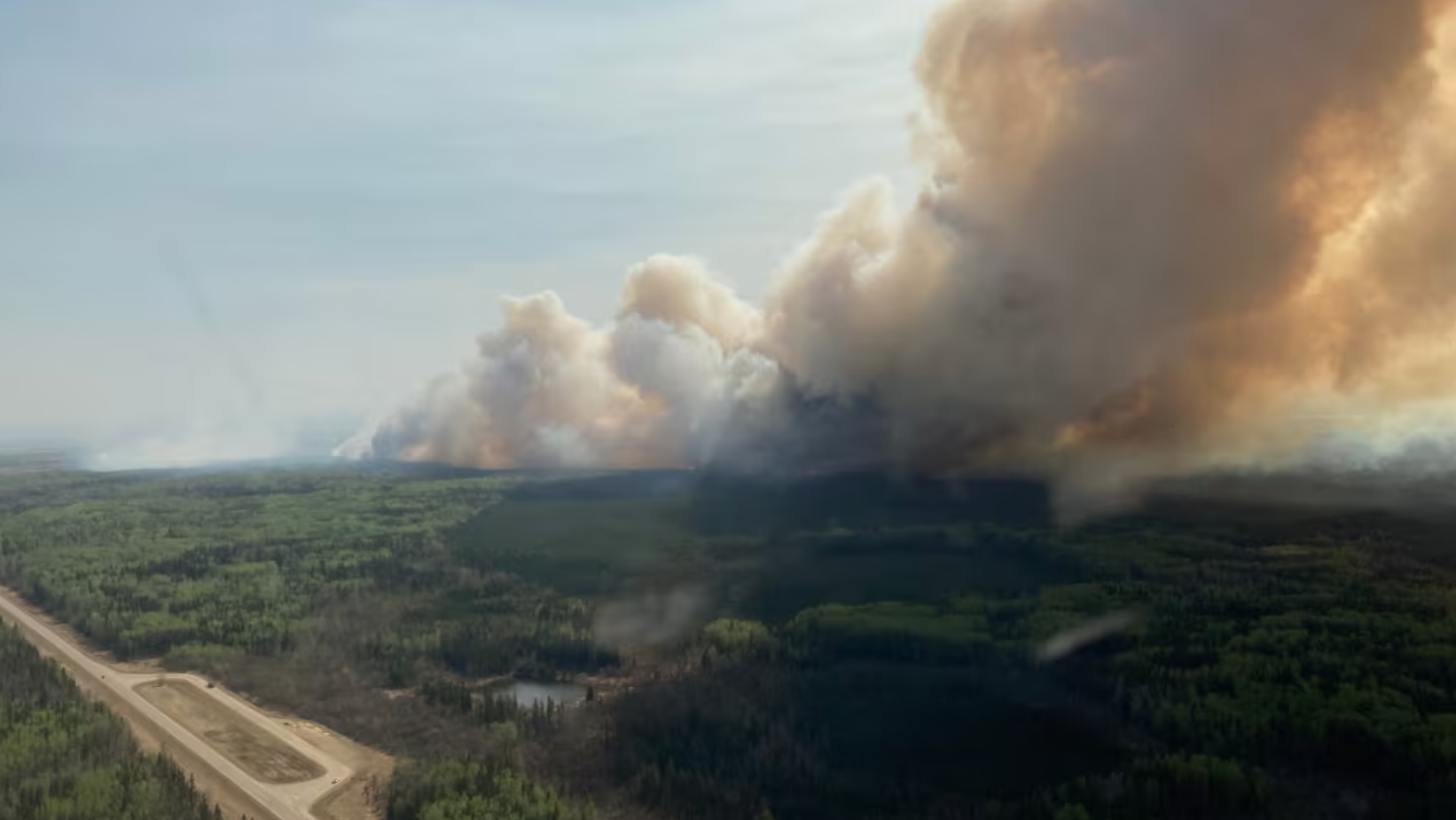
On Thursday, the fire in the Fox Lake area forced thousands of people from their homes. According to an update from Alberta Wildfire on Thursday afternoon, the wildfire covers about 4,400 hectares (~11,000 acres). Alberta Wildfire has forest area updates and fire data online, with maps and annual statistics on its Wildfire Status Dashboard website.

Making a decision about a proposed planned ignition on a wildfire

How it was done on the Connell Ridge Fire in British Columbia

Evaluating a possible planned ignition on the Connell Ridge Fire in British Columbia
Evaluating a possible planned ignition on the Connell Ridge Fire in British Columbia. Photo: BC Wildfire Service.

The British Columbia Wildfire Service (BCWS) has been working to contain the 4,230-acre Connell Ridge Fire 14 miles south of Cranbrook since it was reported August 1. It was likely started by lightning.

Crews had already completed burnouts (or planned ignitions) on the south flank and southeast corner but on August 19 a decision had to be made about whether to conduct an additional burnout on the southwest side. After a test burn, the Incident Management Team decided not to conduct the burnout.

Map of the Connell Ridge Fire, Aug. 21,1 2022
Map of the Connell Ridge Fire, Aug. 21,1 2022. BCWS.

The BCWS created the explanatory article and illustrations, below, about some of the considerations and steps taken as the decision was being made. It is rather extraordinary for a land management agency, at least in the United States, to provide this degree of transparency and detail about how a suppression decision was made. This could serve as an example for others to follow, especially when “big box” strategies are used that result in burning thousands of acres of green vegetation, too often with insufficient thought about ignition tactics, second order results, air quality, and long term fire effects.

The article below uses the term “guard” in the first paragraph which I believe in this context refers to a completed control line intended to stop the spread of the fire.

Information Officers on Type 1 Incident Management Teams should be capable of creating valuable content like this:


August 21, 2022

Test ignitions were conducted on the morning of August 19, 2022 on the Connell Ridge (N10989) wildfire, in anticipation of implementing planned ignition operations on the southwest corner. These test ignitions allow our crews and operational staff to determine if the unburnt fuels between the fire perimeter and the guard will be receptive to burning.

The area that the small-scale ignition was planned for is in steep terrain where the fire has been naturally burning in a patchy manner as the fire finds drier fuels that are able to ignite. This means there is a lot of unburnt, greener fuel within this area, between the free burning fires edge and the established control lines.

Evaluating a possible planned ignition on the Connell Ridge Fire in British Columbia.
Evaluating a possible planned ignition on the Connell Ridge Fire in British Columbia. Photos: BC Wildfire Service.

The purpose of the planned ignition for this area was to remove that unburnt fuel in an intentional way to secure the control line and achieve containment on the southwest ridge of the fire. This unburnt fuel has the potential to burn on it’s own as these greener fuels continue to dry under the hot and dry weather conditions. While the shorter term forecast for the complex shows patches of precipitation, the precipitation will be minimal and is not guaranteed to fall on the fires. With the longer-term forecast returning to a warming and drying trend early next week, these drying green fuels that may not have seen any additional moisture will continue to dry.

Planned ignitions are a very useful tactic in fire suppression and fire management and are often the safer and more efficient operational tactic. It allows us to bring the fire perimeter down to control lines and creates a more uniform and continuous fire edge which is easier for crews to use direct attack methods on and extinguish hot spots to strengthen control lines and achieve containment. This is also more time-efficient and safer for the crews as they have to spend less time chasing hot spots and patches of free burning fire in rough terrain.

Based on test ignitions on August 19 it was determined that the unburnt fuels would not burn in a way that contributes to the strengthening of the existing control line. This means it will take longer to secure this portion of the fire as crews will now need to focus on targeting the patches and hotspots for extinguishment in order to secure this area of the fire.


The Incident Management Team on the Connell Ridge Fire is also working on the Weasel Creek Fire (N11062) and the Cummings Creek Fire (N11051).

Single engine air tanker makes forced landing in British Columbia

Connell Ridge Fire map, August 3, 2022 forced landing air tanker
Connell Ridge Fire map, August 3, 2022

This article was first published at Fire Aviation.

A single engine amphibious air tanker made a forced landing Tuesday while working on a wildfire in British Columbia.

“This evening a Conair 802 Air Tractor Fireboss Skimmer aircraft experienced an engine failure during operations on the Connell Ridge Wildfire, near Cranbrook,” said BC Wildfire Service Executive Director Ian Meier. “The pilot conducted a successful forced landing and was transported to receive medical assessment. Our thoughts are with the pilot involved in this incident as well as their family, friends and colleagues. The BC Wildfire Service is providing all possible assistance to the pilot and Conair.”

Jeff Berry, Director of Business Development with Conair Aerial Firefighting confirmed the pilot was able to walk away unharmed from the aircraft to a helicopter and was transported to Cranbrook for assessment by paramedics.

“His skill and training as an aerial firefighting pilot under challenging circumstances enabled him to execute an exceptional emergency maneuver resulting in a safe outcome,” said Berry. “He was faced with a problem with the engine, he went through his emergency procedures, and put the aircraft down in such a way that he was able to walk away unharmed. Faced with a difficult bunch of decisions in a very, very short period, he did exceptionally well.”

The Connell Ridge Fire 14 miles south Cranbrook, BC has burned approximately 1,235 acres  (500 hectares) since it was discovered August 1, 2022.

File photo of an Air Tractor 802 Fire Boss operated by Conair. Not necessarily the aircraft involved in the incident.

Thanks and a tip of the hat go out to Mike.

Nohomin Creek Fire near Lytton, BC prompts evacuations

At least six home have been destroyed

Updated 6:59 p.m. MDT July 16, 2022

Nohomin Creek Fire July 16, 2022
Nohomin Creek Fire, looking north up the Fraser River towards the Stein Valley. BC Fire Service photo, 3:39 p.m. MDT July 16, 2022.

The British Columbia Fire Service reported at 4:02 p.m. Saturday that the fire activity on the Nohomin Creek Fire northwest of Lytton, BC has been stable today and no major growth was observed. Ground crews and aviation resources are working on the south, east, and north flanks. The western flank  is moving upslope in steep, difficult to access terrain, the agency said.

The Stein Valley Nlaka’pamux Heritage Park is partially closed. Currently, there are no impacts to Highway 1 or Highway 12. The Lytton Ferry is closed in both directions.

There was no update on the size, and it is still reported at 1,500 hectares (3,700 acres).


10:32 a.m. MDT July 16, 2022

Nohomin Creek Fire Lytton, BC
Nohomin Creek Fire Lytton, BC, July 14, 2022. BC Wildfire Service.

The Nohomin Creek Fire on the west side of the Fraser River northwest of Lytton, British Columbia has burned approximately 1,500 hectares (3,700 acres) since it was reported Thursday July 14. Judging from these photos shot that day it spread very rapidly.

Fire officials said Friday that at least six homes have been destroyed, and that number could rise.

The BC Wildfire Service reports that the fire behavior is rank four and rank five, meaning it is crowning, has a moderate to fast rate of spread, and is exhibiting short-range spotting.

Nohomin Creek Fire map Lytton BC
Nohomin Creek Fire map. The red dots represent heat detected by satellites as late as 7 a.m. MDT July 16, 2022.

Winds of 30 to 40 kilometers per hour (19 to 26 miles per hour) are pushing the fire west away from communities, according to the BC Wildfire Service in a Friday evening update. At that time there were no impacts to Highway 1 or Highway 12. The Lytton Ferry is closed in both directions.

The two photos below were taken the day the fire started.

Nohomin Creek Fire Lytton BC
(1) Nohomin Creek Fire across the river from Lytton, BC, July 14, 2022.
Nohomin Creek Fire Lytton, BC
(2) Nohomin Creek Fire across the river from Lytton, BC, at 3 p.m. July 14, 2022.

Evacuations are in effect. Lytton First Nation has the details.

In late June of 2021 the Lytton Creek Fire burned more than 83,700 hectares (206,000 acres) and destroyed 90 percent of the village of Lytton. Two civilians were killed in the fire.

BC Wildfire Service moves to a year-round workforce

The agency employs approximately 1,000 wildland firefighters

BC Wildfire Service 2022 budget
Minister of Finance Selina Robinson presented the 2022 budget for British Columbia on February 22, 2022.

The government of British Columbia intends to move to a year-round workforce for the Wildfire Service in the next fiscal year that begins April 1. In a February 22 presentation Minister of Finance Selina Robinson said, “$145 million in new funding will strengthen B.C.’s emergency management and wildfire services.  The BC Wildfire Service will shift from a reactive to a proactive approach by moving to a year-round workforce that will deliver all pillars of emergency management: prevention and mitigation, preparedness, response and recovery.”

The BC Wildfire Service employs approximately 1,000 wildland firefighters each year.

The new budget will allow improvements of the public alerting system for wildfires and help support people and communities during climate-related events.

An additional $98 million will fund wildfire prevention work and maintain forest service roads used to respond to forest fires.

The budget also includes $210 million to support community climate change preparedness and emergency management, including through the FireSmart program, the Community Emergency Preparedness Fund, and Indigenous-led emergency management priorities. It will support communities and First Nations to build more resilient dikes and map floodplains.

Smoke forecast, 11 pm MDT July 31, 2021

Smoke forecast
Smoke forecast for 11 p.m. MDT July 31, 2021.

For the last couple of days wildfires in Southern British Columbia have been producing large quantities of smoke which has been drifting into Alberta, North-central US, the American Midwest, and points further east. The forecast for Saturday night indicates this trend is continuing.

Clouds have made it difficult for satellites to photograph smoke coming from the Bootleg Fire in Oregon and the Dixie Fire in California.

Satellite photo smoke wildfires British Columbia Montana
Satellite photo showing smoke from fires in BC and Montana at 7:40 p.m. MDT July 30, 2021.