Report released about firefighter fatality — trees were broken off during retardant drop

 Draper City, Utah Battalion Chief Matthew Burchett was killed when a low drop uprooted an 87-foot tall tree that fell on him

Diagram fatality air tanker drop Green Sheet
Diagram from the Green Sheet.

(Originally published on FireAviation, September 14, 2018. Updated at 7:43 MDT September 14, 2018)

The California Department of Forestry and Fire Protection (CAL FIRE) has released what they call a “Green Sheet” report about the fatality and injuries that were caused by falling tree debris resulting from an air tanker’s retardant drop. The accident occurred on the Ranch Fire which was part of the Mendocino Complex of Fires east of Ukiah, California. The report was uploaded to the Wildland Fire Lessons Learned Center on September 13, 2018 exactly one month after the August 13 accident.

A firefighter from Utah, Draper City Battalion Chief Matthew Burchett, was killed when a low drop uprooted an 87-foot tall tree that fell on him. Three other firefighters had different assortments of injuries from sheered-off trees and limbs, including broken ribs, deep muscle contusions, ligament damage to extremities, scratches, and abrasions.

747 supertanker palmer fire
File photo: The 747 SuperTanker drops on the Palmer Fire south of Calimesa and Yucaipa in southern California, September 2, 2017. Photo by Cy Phenice, used with permission.

Standard procedure is for firefighters to leave an area before an air tanker drops. The report said the personnel on that Division were told twice that day to not be under drops — once in a morning Division break-out briefing, and again on the radio before the fatal drop and three others from large air tankers were made in the area. It was not confirmed that all supervisors heard the order on the radio to evacuate the drop area.

One of the “Incidental Issues / Lessons Learned” in the report mentioned that some firefighters like to record video of air tanker drops:

Fireline personnel have used their cell phones to video the aerial retardant drops. The focus on recording the retardant drops on video may distract firefighters. This activity may impair their ability to recognize the hazards and take appropriate evasive action possibly reducing or eliminating injuries.

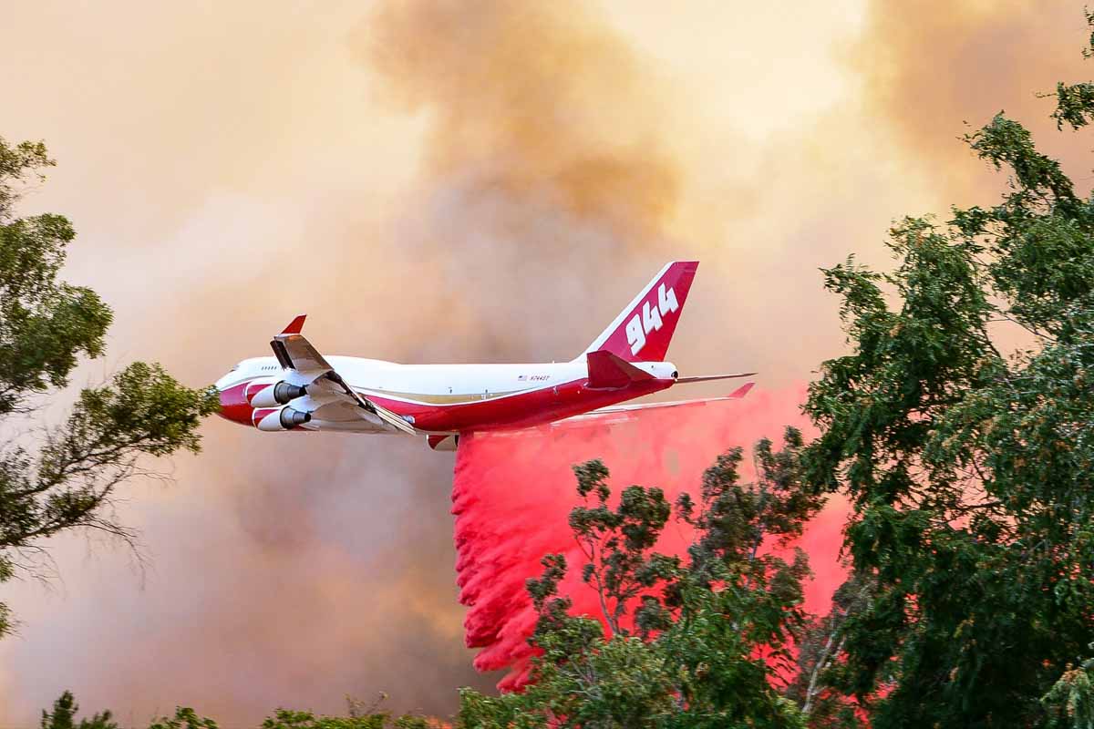
The air tanker that made the drop was T-944, a 747-400 that can carry up to 19,200 gallons. Instead of a more conventional gravity-powered retardant delivery system, the aircraft has pressurized equipment that forces the retardant out of the tanks using compressed air. This is similar to the MAFFS air tankers. When a drop is made from the recommended height the retardant hits the ground as a mist, falling vertically, rather than the larger droplets you see with a gravity tank.

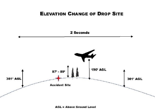
In this case, according to the report, the drop was made from approximately 100 feet above the tree tops. The report stated:

The Aerial Supervision Module (ASM) identified the drop path to the VLAT by use of a smoke trail. The VLAT initiated the retardant drop as identified by the smoke trail. Obscured by heavy vegetation and unknown to the VLAT pilot, a rise in elevation occurred along the flight path. This rise in elevation resulted in the retardant drop only being approximately 100 feet above the treetops at the accident site.

When a drop is made from a very low altitude with any air tanker, the retardant is still moving forward almost as fast as the aircraft, as seen in this drop. If it is still moving forward there will be “shadows” that are free of retardant on the back side of vegetation, reducing the effectiveness of the drop. From a proper height retardant will gradually slow from air resistance, move in an arc and ideally will be falling gently straight down before it hits the ground. Another example of a low drop was on the Liberty Fire in Southern California in 2017 that dislodged dozens of ceramic roofing tiles on a residence and blew out several windows allowing a great deal of retardant to enter the home.

We reached out with some questions to Global Supertanker, the company that operates the 747 Supertanker, and they gave us this statement:

We’re heartbroken for the families, friends and colleagues of Chief Burchett and the other brave firefighters who were injured during their recent work on the Mendocino Complex Fire. As proud members of the wildland firefighting community, we, too, have lost a brother.

On August 13, 2018, Global SuperTanker Services, LLC acted within procedural and operational parameters. The subject drop was initiated at the location requested by the Aerial Supervision Module (ASM) after Global SuperTanker Services, LLC was advised that the line was clear.

The former President and CEO of the company, Jim Wheeler, no longer works there as of September 1, 2018. The company is owned by Alterna Capital Partners LLC, of Wilton, Conn.

(Updated at 7:43 MDT September 14, 2018 to include the statement from Global Supertanker that we received at 7:35 p.m. MDT September 14, 2018)

Dozer operator killed in vehicle accident in California

He was driving to the North Fire on I-80

Tuesday morning September 11 at about 5:45 a.m., Antonio (Tony) Flores 37, an employee of Kent Siller Trucking, was involved in a fatal vehicle accident on Interstate 80 near Blue Canyon, California between Sacramento and Reno. Mr. Flores was assigned to the North Fire as a private contractor operating a bulldozer. He was driving to the incident command post at the Blue Canyon Airport.

Incident Commander Curtis Coots said that the personnel working on the North Fire are deeply saddened by the death of a fellow firefighter. “This has been an extremely tough fire season for our firefighters both physically and emotionally”, Mr. coots said.

Mr. Flores is survived by his wife of 18 years and four children, ranging in ages from 9 to 16 years old. He is a lifelong resident of the Yuba City area.

He has worked for Kent Siller Trucking for more than 20 years as a master mechanic and heavy equipment operator.

The cause of the accident is under investigation by the California Highway Patrol and the Placer County Sheriff-Coroner’s Office.

Since it started September 3 the North Fire has burned 1,120 acres nine miles northeast of Alta, Calif. It has not grown in the last 24 hours and will transition back to the local unit today, September 12.

Our sincere condolences go out to Mr. Flores’ family, friends, and co-workers.

Thanks and a tip of the hat go out to Tom.
Typos or errors, report them HERE.

Delta Fire adds another 6,000 acres

The fire is 24 miles north of Redding, California. Interstate 5 is now open, one lane in each direction

Sikorsky Air-Crane helicopter Delta Fire
A Sikorsky Air-Crane working on the Delta Fire. USFS photo.

(UPDATED at 2:37 p.m. PDT September 10, 2018)

Interstate 5 is now open. Officials reopened the highway Monday morning, with one lane available in each direction through the fire area. The lane restriction is in effect  for 17 miles between Antlers Bridge in Lakehead and Flume Creek Road, south of Dunsmuir, Caltrans said in a statement.


(UPDATED at 8:52 a.m. PDT September 10, 2018)

Firefighters are making progress, slowly, on the 46,150-acre Delta Fire which has forced the closure of Interstate 5 north of Redding, California. Some of the challenges they are facing include very steep, remote terrain and inversions that trap smoke making aerial support difficult or impossible at times.

One of their goals is to contain the spread near the Interstate so that the very important transportation corridor can be reopened. But in addition to that, thousands of hazardous trees near the highway have be evaluated and mitigated and guard rails destroyed by the fire have to be replaced.

On the southeast side of the fire east of the Interstate crews firing out along a dozer line had a setback when the fire spotted across, requiring them to back off and come up with a modified plan. The firing operation along a dozer line on the north side of the fire west of I-5 appears to be going well, but slowly due to unfavorable winds.

map Delta Fire California Interstate 5
Map of the Delta Fire showing the perimeter (in red) at 12:30 a.m. PDT September 10, 2018. The white line was the perimeter about 24 hours before. The red shaded areas represent intense heat detected by the sensor on the fixed wing mapping aircraft. Click to enlarge.

(UPDATED at 9:55 a.m. PDT September 9, 2018)

Daily inversions have been restricting the growth of the Delta Fire 24 miles north of Redding, California. This atmospheric condition can trap smoke, reduce the visibility for aircraft attempting to drop water or retardant on the fire, keep the relative humidity higher than normal, and prevent direct sunlight and strong winds from influencing the fire.

But in spite of the inversion the fire has continued to grow over the last two days along most of the perimeter, adding thousands of acres each day. A mapping flight Saturday night determined that almost 4,000 acres had burned since the previous night bringing the total up to 40,580.

3-D Delta Fire Map
A 3-D map of the Delta Fire looking north, showing the perimeter at 9 p.m. PDT September 8, 2018. Click to enlarge.

Firefighters are conducting at least two large firing operations. One of them is 2 miles west of I-5 on the north side of the fire along a 5-mile long dozer line stretching from the Interstate west up to a 6,500-foot ridge. At 9 p.m. Saturday about three-quarters of a mile had been completed on this project.

(To see the all of the articles on Wildfire Today about the Delta Fire including the most recent, click here: https://wildfiretoday.com/tag/delta-fire/)

The other large firing operation is on the southeast side between I-5 and the Hirz Fire. This is proceeding down a dozer line constructed as a contingency line during the battle to contain the Hirz Fire. The dozer line can be seen in black on the map below and the one above.

A 3-D map of the Delta Fire looking west, showing the perimeter at 9 p.m. PDT September 8, 2018. Click to enlarge.

Two spot fires have been growing slowly on the northwest side of the fire southeast of Pond Lily Lake above 5,000′ elevation. They are most likely low priority to deal with, considering that stopping the spread of the fire along Interstate 5 so it can be reopened has to be near the top of the Things To Do list. There is no word on when this major highway will be open to traffic again. About 45 miles of the Interstate are closed.

Evacuations are still in effect for the communities of Delta, Lamoine, Pollard Flat, Sims and Castella. The Trinity County Sheriff’s Office Facebook page has the most current evacuation information.

Two structures have been destroyed, but officials have not specified if they were residences or out buildings. Approximately 2,132 personnel are assigned to the fire.


(UPDATED at 1:14 a.m. PDT September 8, 2018)

The Delta Fire 24 miles north of Redding, California on Friday added another 12,000 acres moving north, south, east, and west through the Shasta-Trinity National Forest. Overnight mapping determined that the fire has burned almost 37,000 acres.

Shortly after it started on September 5 it crossed and forced the closure of Interstate 5, the main north-south highway in Northern California.   It continued to spread east and has merged with the 46,000-acre Hirz Fire. The two fires now share a two-mile long section of their perimeters. Unless the weather changes, that sharing is likely to increase especially on the southeast side of the Delta Fire north of Lakehead where there is the potential to have another 5 miles of common fire edge.

Delta fire
DO NOT ENTER. InciWeb photo.

Multiple commercial vehicles and several structures have been damaged or destroyed.

Continue reading “Delta Fire adds another 6,000 acres”

Report on dozer rollover on the Carr Fire in Northern California

CAL FIRE has released a “Green Sheet” report on the accident that occurred August 1, 2018

The California Department of Forestry and Fire Protection (CAL FIRE) has released a Green Sheet report about the rollover of a dozer that occurred August 1, 2018 on the Carr Fire west of Redding, California.

Below are excerpts from the 14-page report:

“At approximately 7:00 AM on Tuesday, July 31, 2018, two CWN bulldozers (DOZ1 and DOZ2) were 24 hour resources assigned to Branch III, Division D on the Carr incident. DOZ1’s operator (OP1) had been assigned to the same area on the previous 24-hour operational period (south of HWY 299E on County Line Road) and worked the night shift (7:00 PM to 7:00 AM). OP1 had 4 years of bulldozer operating experience and at least 17 years in the logging industry. OP1 had used the bulldozer extensively in Sonoma and Napa counties in the Fall of 2017.

[…]

“At approximately 12:30 AM, STL1 looked toward DOZ1, located up the spur ridge and observed DOZ1 close to the steeper east aspect of the spur ridge. From STL1’s vantage point, DOZ1 was facing him and appeared to be tilted to the right at approximately 40-45 degrees. STL1 observed DOZ1 attempt to climb back to the center of the spur ridge in reverse. While DOZ1 backed, STL1 further observed the front of DOZ1 abruptly rotated 90 degrees to the left and the front of the dozer lift into the air. DOZ1 then lost traction and slid backwards downhill, at which time STL1 saw DOZ1 roll twice, end over end, before he lost sight of it down the slope. STL1 could hear DOZ1 continue to roll down the slope, and then stop. STL1 went to the edge of the slope where DOZ1 left the ridgetop, and could see DOZ1 approximately 300 feet downslope.

“At approximately 12:32 AM, STL1 notified Branch II (t) of the accident and his intention to proceed to DOZ1 to ascertain injuries and needs. STL1 contacted DOZ2 to cease operations and then proceeded to DOZ1’s location. Branch II Safety Officer and Division C Fireline Medics responded to the accident site. Carr Communications was notified of the accident at 12:34 AM by Branch II (t).

“While walking downslope to DOZ1, STL1 heard the engine speed fluctuating up and down. STL1 found the dozer upright on its tracks with the cab still intact. STL1 observed movement inside the bulldozer cab. DOZ1 appeared to be stable and STL1 boarded the dozer on the uphill (right) side. The right cab door was jammed and would only open a couple of inches. STL1 contacted OP1 and did a quick visual assessment. OP1 suffered injuries to the head but was alert and oriented.

“At approximately 12:35 AM, STL1 updated Branch II (t) of OP1’s condition via radio. Branch II (t) advised STL1 to follow the “Incident Within an Incident” protocol in the Incident Action Plan. OP1 self-extricated through the left cab door. With OP1 sitting on the ground, STL1 performed a thorough secondary patient assessment. A night hoist capable helicopter was requested due to mechanism of injury, patient location, and extended ground transport time to a medical facility. A California National Guard night vision equipped 24-hour helicopter medivac resource, assigned to the incident, responded from Redding Helibase and an Advanced Life Support ground ambulance was dispatched to Hwy 299E and County Line Road (Buckhorn Summit) from their staging area in west Redding.

“Division C Fireline Medics arrived at the accident site at 1:35 AM. Due to a heavy smoke inversion, the helicopter experienced difficulty accessing the accident site and at 2:01 AM, Division C Medics cancelled the helicopter and walked OP1 out to meet the ground ambulance. OP1 was transferred to the ALS ambulance at 2:43 AM and began transport to Mercy Medical Center with a 2-hour estimated time of arrival…”

Carr Fire Dozer Rollover California
The rollover path of the dozer accident on the Carr Fire, August 1, 2018. Image from the CAL FIRE Green Sheet.

Delta Fire, updated information, September 7, 2018

The blaze north of Redding, California has grown to 24,558 acres

Delta Fire Map
Delta Fire. Map by Incident Management Team, released Friday morning, Sept. 7. Click to enlarge.

Fire officials said Friday morning that the Delta Fire 24 miles north of Redding, California has grown to 24,558 acres, an increase of more than 2,000 acres since Thursday.

While the fire is steadily growing, it is moving at a much slower rate than it did the day it started, Wednesday, when it burned over 15,000 acres in the first nine hours.

(To see the all of the articles on Wildfire Today about the Delta Fire including the most recent, click here: https://wildfiretoday.com/tag/delta-fire/)

On Thursday firefighters were working on a firing operation on the east side of the fire that would tie it in with the 46,000-acre Hirz Fire, checking the spread on the east side of Interstate 5 and keep it from moving farther north in that area. At 2:24 a.m Friday a satellite detected a lot of heat in that area, so it is uncertain if they were successful.

The map above was released by the incident management team Friday morning; the date and time of the data used to map the perimeter is unknown. The satellite passing 200 miles above the fire at 2:24 a.m Friday  detected heat one or two miles farther north along both sides of Interstate 5, which is still closed, reaching almost as far north as the off ramp at Fisher (see the map below).

Delta Fire Map
Map of the Delta Fire. The red line was the perimeter mapped by a fixed wing aircraft at 10 p.m. MDT Sept. 5. The yellow line is the APPROXIMATE growth since then based on heat detected by satellites at 2:24 a.m. PDT September 7 (the red dots) and before. Click to enlarge.

There was no overnight mapping by a fixed wing aircraft Thursday night. One of the two U.S. Forest Service infrared scanning planes was down with mechanical difficulties, which could be the reason for the “unable to fill”. It was smoky over the fire during the night but that usually does not prevent imaging the fire, unlike clouds which prevent the infrared light from reaching the sensor on the aircraft. The ability to “see” through smoke is one of the primary attributes of infrared sensing technology. However an intense convection column containing smoke, ash, and burning embers can be confused with heat on the ground.

During the large vegetation fires in southern California in 2003 some of the convection columns were so powerful that the windshields on six air tankers were cracked by chunks of debris that were being hurled into the air (page D-6 in 2003 California Governor’s Blue Ribbon Report; huge 20 Mb file). One pilot saw a four by eight sheet of plywood sail past at 1,500 feet.

Delta Fire north of Redding grows to 22,000 acres

The fire has closed Interstate 5 and is causing evacuations 24 miles north of Redding, California.

Delta Fire, September 5, 2018
Delta Fire, September 5, 2018. InciWeb photo. Click to enlarge.

(UPDATED at 7:15 p.m. PDT September 6, 2018)

The Delta Fire 24 miles north of Redding, California has grown to approximately 22,000 acres according to the latest estimate from fire officials.

(To see the all of the articles on Wildfire Today about the Delta Fire including the most recent, click here: https://wildfiretoday.com/tag/delta-fire/)

Crews have worked to anchor the south end of the fire along Dog Creek. To stop the fire’s northern spread and protect structures firefighters have started a backfiring operation east of Interstate 5 from Pollard Flats to the western side of the Hirz Fire near Salt Creek Road. Many of the contingency firelines on the eastern side of the Hirz Fire may be used in the efforts to control the Delta Fire.

Evacuations are being managed by the Shasta County Sheriff’s Office.

The maps below show the perimeter of the Delta Fire. The red lines were the edge of the fire at 10 p.m. PDT on September 5 as mapped by a fixed wing aircraft. The white lines represent the APPROXIMATE location of additional growth between then and 2:04 p.m. PDT on September 6, based on heat detected by a satellite.

map Delta Fire I-5 California
The red lines were the edge of the fire at 10 p.m. PDT on September 5 as mapped by a fixed wing aircraft. The white lines represent the APPROXIMATE location of additional growth between then and 2:04 p.m. PDT on September 6, based on heat detected by a satellite.
map Delta Fire I-5 California
3-D map. The red lines were the edge of the fire at 10 p.m. PDT on September 5 as mapped by a fixed wing aircraft. The white lines represent the APPROXIMATE location of additional growth between then and 2:04 p.m. PDT on September 6, based on heat detected by a satellite.


(Originally published at 6:17 a.m. PDT September 6, 2018)

The Delta Fire has closed Interstate 5 and is causing evacuations 24 miles north of Redding, California. Nine hours after it was reported at 12:51 p.m. PDT on September 5 a mapping flight found that it had burned 15,294 acres. A heat-detecting satellite four hours later saw an additional 4,000 acres on the northwest and northeast sides of the fire.

map Delta Fire California
The red lines on the map were the perimeters of the Delta Fire and the Hirz Fire at 10 p.m. PDT September 5, 2018. The red dots represent heat detected by a satellite at 2:42 a.m. PDT September 6. The red shaded area was intense heat. Click to enlarge.

Interstate 5, the primary north/south highway in Northern California, is closed from 10 miles north of Redding at Fawndale Road to 3 miles south of Mount Shasta at Mott Road. The fire is burning on both sides of the Interstate along a five-mile stretch.

The Shasta County Sheriff’s Office conducted evacuations on both sides of I-5 north of Lakehead to the Shasta/Siskiyou county line. An evacuation center is at the Mt. Shasta Community Center, 629 Alder St. in Mt. Shasta.

map Delta Fire California
Vicinity map showing the location of the Delta, Hirz, and Carr fires. The red lines were the perimeters at 10 p.m. PDT September 5, 2018. The red dots represent heat detected by a satellite at 2:42 a.m. PDT September 6.

California Interagency Incident Management Team 5 (CIIMT5) is now managing the Delta Fire in addition to the nearby Hirz Fire which was winding down. On Wednesday 466 personnel were demobilized from the 46,000-acre Hirz Fire 2 miles east of the Delta Fire, leaving about 1,400 on the Hirz Fire. The heat detected by a satellite at 2:42 a.m. PDT on Thursday indicates that the two fires may have already merged.

Delta Fire
Delta Fire, September 5, 2018. Photo by Mark Thibideau.

Initially reported as three fires, they merged into one, exhibiting extreme fire behavior with rapid rates of spread up to one mile per hour. Wednesday evening the fire front was more than three miles wide on the northern side with 300-foot flame lengths.