Firefighters battling South Fork Fire east of Wawona, California

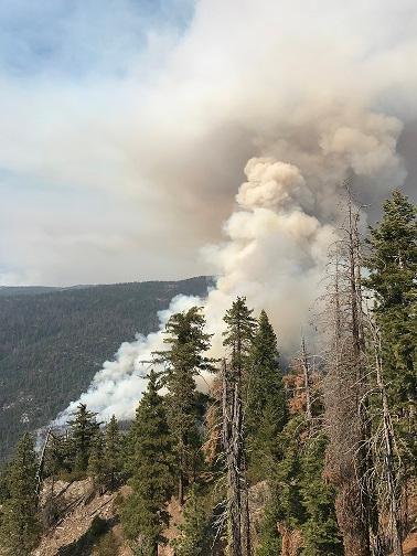
Above: South Fork Fire. Inciweb.

(Originally published at 11:38 a.m. PDT August 15, 2017)

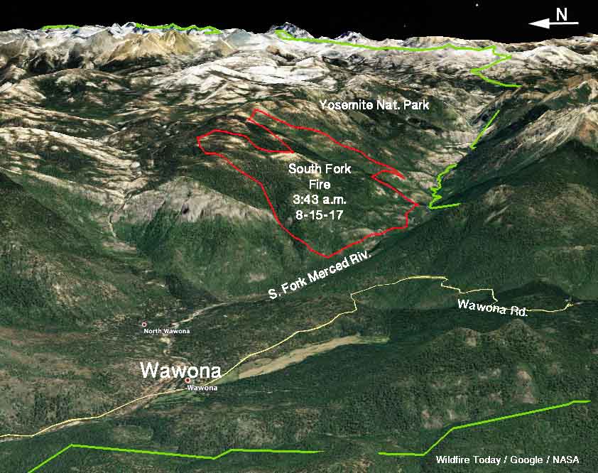
The main priority of firefighters battling the South Fork Fire in Yosemite National Park in California is protecting homes in the North Wawona community 1.7 miles west of the fire along the South Fork of the Merced River.

Not much information is available about the fire 56 hours after it was reported very early Sunday morning, but we know that it is burning above the river on steep, rocky slopes in a forested area with beetle-killed trees. While a fire burning through dead trees sounds scary, after the needles fall off, the trees burn with less intensity and rate of spread than a healthy forest.

According to the South Zone Coordination Center, voluntary evacuations are in effect for Wawona on the east side of Chilnaulna Falls Ridge.

Our very unofficial estimate based on satellite data from 3:43 a.m. PDT Tuesday puts it at approximately 2,000 acres. The last official figure from the Incident Management Team was 1,613 acres at 7 p.m. Monday.
map South Fork Fire
3-D map of the South Fork Fire. Estimated perimeter (in red) based on satellite data from 3:43 a.m. PDT August 15, 2017.

Deron Mills’ Type 2 Incident Management Team is transitioning into the management structure of the fire today, Tuesday.

The weather forecast for the fire area for Tuesday calls for sunny skies, 75 to 80 degrees, relative humidity in the mid-30s, and very light winds on the slopes in the morning increasing to 10 mph on the ridgetops in the afternoon.

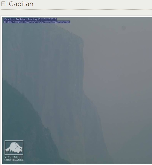
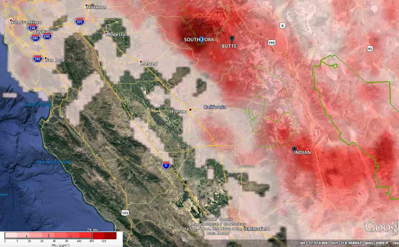
The South Fork Fire and others in California are contributing to unhealthy air quality in many areas.
visibility in Yosemite National Park El Capitan
The visibility in Yosemite National Park at El Capitan, 12:02 p.m. PDT August 15, 2017.
pm25 air quality california wildfire
The forecast for the maximum levels of wildfire particulate matter (PM 2.5) for August 15, 2017 in Central California. Experimental product by U.S. Forest Service/BlueSky.

2 fires in Yosemite National Park, Empire and South Fork

Above: Satellite photo of the South Fork and Empire Fires in Yosemite National Park, August 14, 2017.

(Originally published at 3:40 a.m. PDT August 14, 2017)

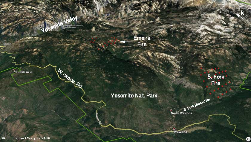
Two large fires are burning in Yosemite National Park. The Empire Fire started two weeks ago and is being monitored but not completely suppressed. It has spread across 1,200 acres one mile south of Bridalveil Campground in Yosemite’s Wilderness.

The first report of the South Fork Fire came in at 2:30 a.m. Sunday, August 13 near the South Fork of the Merced River 2.6 miles east of Wawona.

South Fork Fire
South Fork Fire. Posted on InciWeb August 14, 2017.

It has burned approximately 1,000 acres. Smoke has prevented the use of air tankers at times, but there is a report that all three of the military MAFFS aircraft currently activated have dropped on the fire when the smoke has cleared.

A Type 2 Incident Management Team has been ordered.

South Fork Fire map empire
3-D map of the South Fork and Empire Fires in Yosemite National Park, August 14, 2017.

Eight firefighters injured in northern California vehicle accident

A crew truck from Firestorm Wildland Fire Suppression was involved in the one-vehicle accident.

firestormAt approximately 7:45 a.m. PDT, August 11, 2017, a Firestorm Wildland Fire Suppression Inc. contracted fire crew transport truck assigned to the Parker 2 Fire was involved in a single vehicle accident on Highway 299 near Cedarville, California. Eight firefighters were injured. Five were transported to local medical facilities by ambulance; three were transported by air ambulance. Seven of the firefighters have been treated and released, and one firefighter is still undergoing medical evaluation.

The truck rolled over after the driver tried to avoid hitting a vehicle that had stopped due to deer being in the road.

The Parker 2 Fire has burned almost 8,000 acres on the Modoc National Forest east of Alturas, California.

Thanks and a tip of the hat go out to Rick.
Typos or errors, report them HERE.

400 firefighter hand crews are deployed on fires in the United States

Above: A firefighter ignites a burnout on the Powerline Fire southwest of Pocatello, Idaho. Uncredited Inciweb photo, posted August 6, 2017.

(Originally published at 12:48 p.m. MDT August 6, 2017)

Wildland firefighters are much busier this year than in a typical year. To date, fires have burned 46 percent more acres than the 10-year average — 5,820,802 acres vs. the 3,962,906 average. In some years fire activity in Alaska, where many very large fires are not suppressed, can inflate these numbers, but so far that state can only account for 626,786 acres, not a huge number for Alaska.

400 hand crews, usually comprised of 20 people each, are deployed nationwide, along with 949 fire engines, and 120 helicopters for a total of 16,673 personnel.

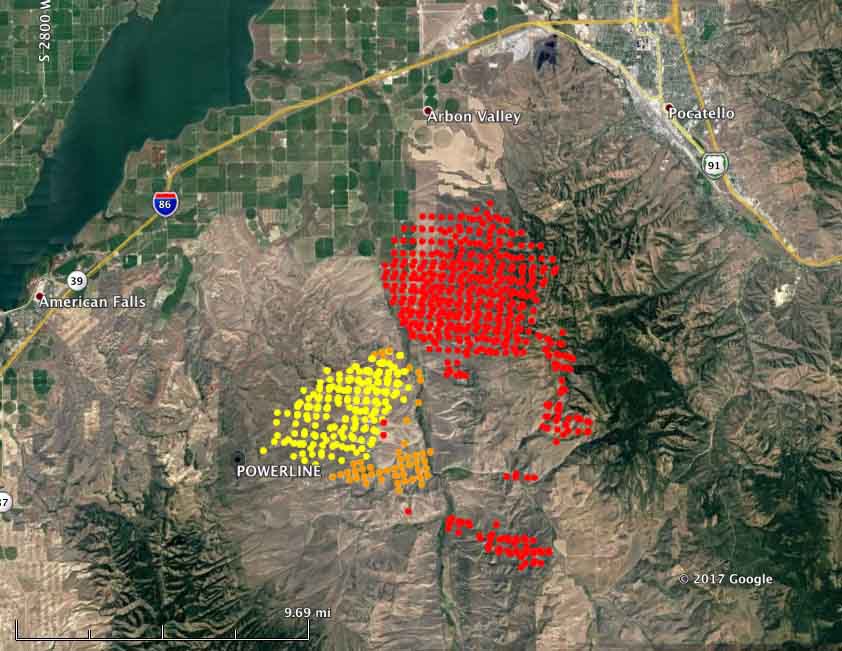
map powerline fire
Map showing heat detected on the Powerline Fire southwest of Pocatello, Idaho by a satellite August 5 and 6, 2016. The red dots are the most current, at 4:04 a.m. MDT August 6. Some areas with light vegetation, such as grass, may have burned and cooled before the satellite overflight and were not detected.

Here are brief descriptions of some of the larger or more prominent fires:

  • Powerline (see the map and photo above): Since it was reported Friday night this fire has spread very rapidly. Saturday it was very active on the northeast and southeast sides. Using satellite data the Incident Management Team estimated early Sunday morning that it had burned over 40,000 acres, but that is a very rough guess. More accurate mapping by fixed wing aircraft will provide better numbers. The satellite information indicated that by 4:04 a.m. Sunday it had spread to within 6 miles of Pocatello, Idaho. It is moving into steeper terrain with heavier fuels, offering more resistance to control and is the #2 priority in the Great Basin Geographic Area according to the national situation report.
  • Mammoth Cave, southwest of Carey, Idaho. Since it started August 4 it has burned three structures and 30,000 acres. It is the number 1 priority in the Great Basin Geographic Area.
  • The Shoestring Fire between Shoshone and Gooding, Idaho has blackened about 12,000 acres since it started August 5. It is the #3 priority in the Great Basin Geographic Area.
  • The Rice Ridge Fire northeast of Seeley Lake, MT is the #1 priority in the Northern Rockies Geographic Area and is threatening over 1,000 structures. It added almost 700 acres on Saturday to bring the total to 7,740.
  • The Sunrise Fire, 12,900 acres, the #2 priority in the Northern Rockies Geographic Area, grew by 600 acres Saturday. It has been burning since July 16, growing every day, adding several hundred acres daily on the east or northeast sides. It is now mapped at 12,900 acres.
  • The Hanover Fire, in a very remote area 15 miles northwest of Riggins, Idaho, was extremely active on Saturday. The Incident Management Team reports that it has burned 4,479 acres.
  • Parker 2, 10 miles east of Alturas, California. It was very active Saturday, adding 5,300 acres, growing to 7,100 acres.
  • Minerva 5, just south of Quincy, California. It has burned 4,088 acres and the voluntary evacuation of the town has been lifted. Firefighters completed a firing operation Saturday night.
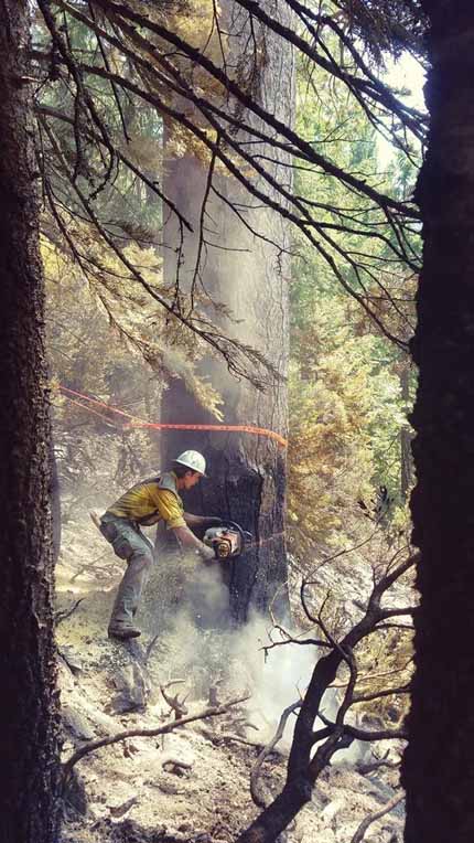
 sawyer Minerva 5 Fire
A sawyer on the Minerva 5 Fire, August 2, 2017. Inciweb photo, uncredited.

Rose Fire near Lake Elsinore, California burns 200 acres

Above:  A firefighter on the Rose Fire near Lake Elsinore, CA, July 31, 2017. Photo by Jeff Zimmerman.

(Originally published at 8:20 p.m. MDT August 5, 2017)

On July 31 firefighters were able to prevent structures from burning as a wildfire burned about 200 acres just northwest of Lake Elsinore in Riverside County, California.

Jeff Zimmerman, who took these photos, said the fire was reportedly started by the use of equipment behind homes in the 100-degree heat. Jeff said heavy air tankers were brought in to help firefighters stop the spread of the fire as it moved up-canyon through heavy chaparral.

For a while homes along several streets in Lake Elsinore were evacuated as well as locations up the hill to the west in the Cleveland National Forest, including the North Main Divide road, El Cariso Campground, and Los Pinos Conservation Camp above El Cariso Village.

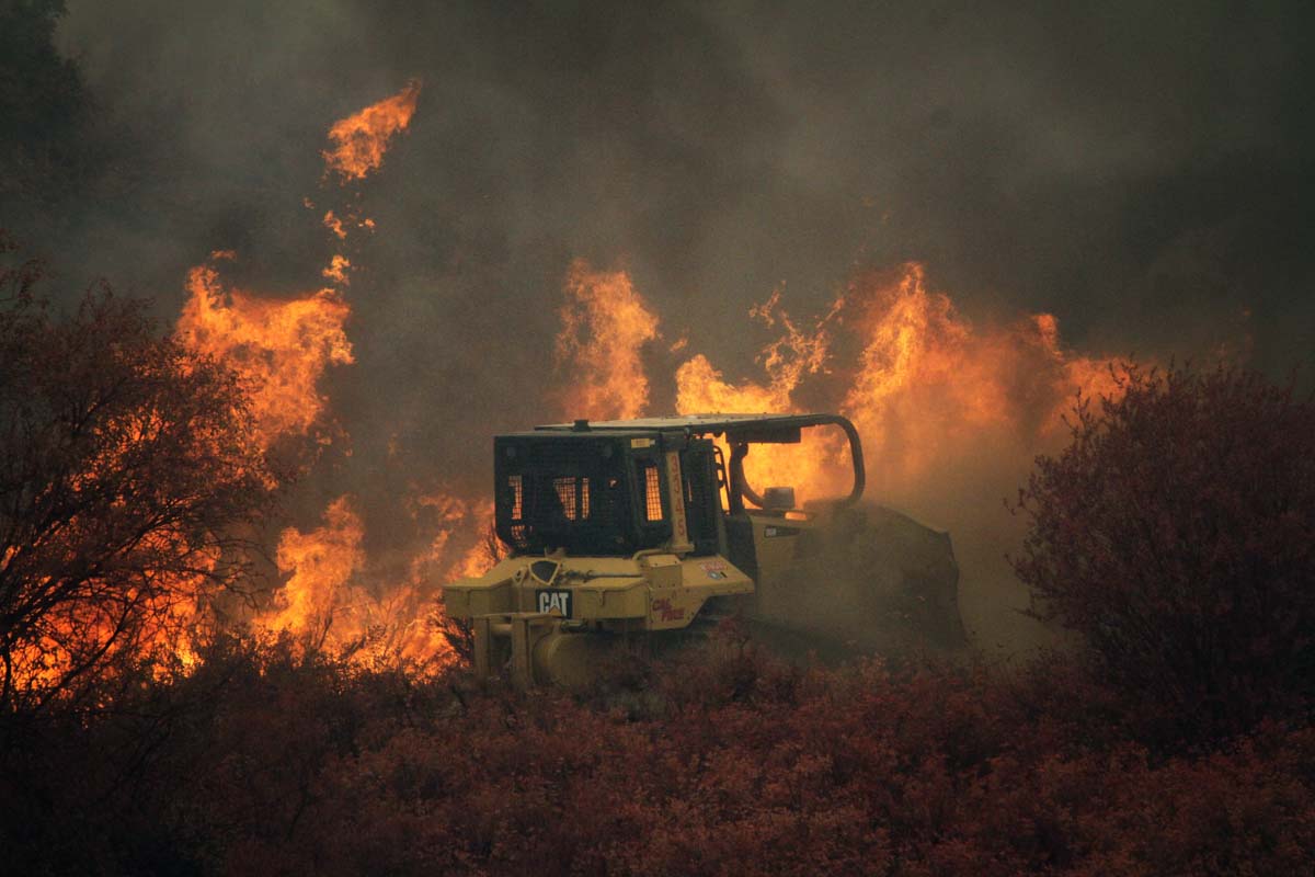
Rose Fire Lake Elsinore CA
A dozer constructs fireline on the Rose Fire near Lake Elsinore, CA, July 31, 2017 Photo by Jeff Zimmerman.
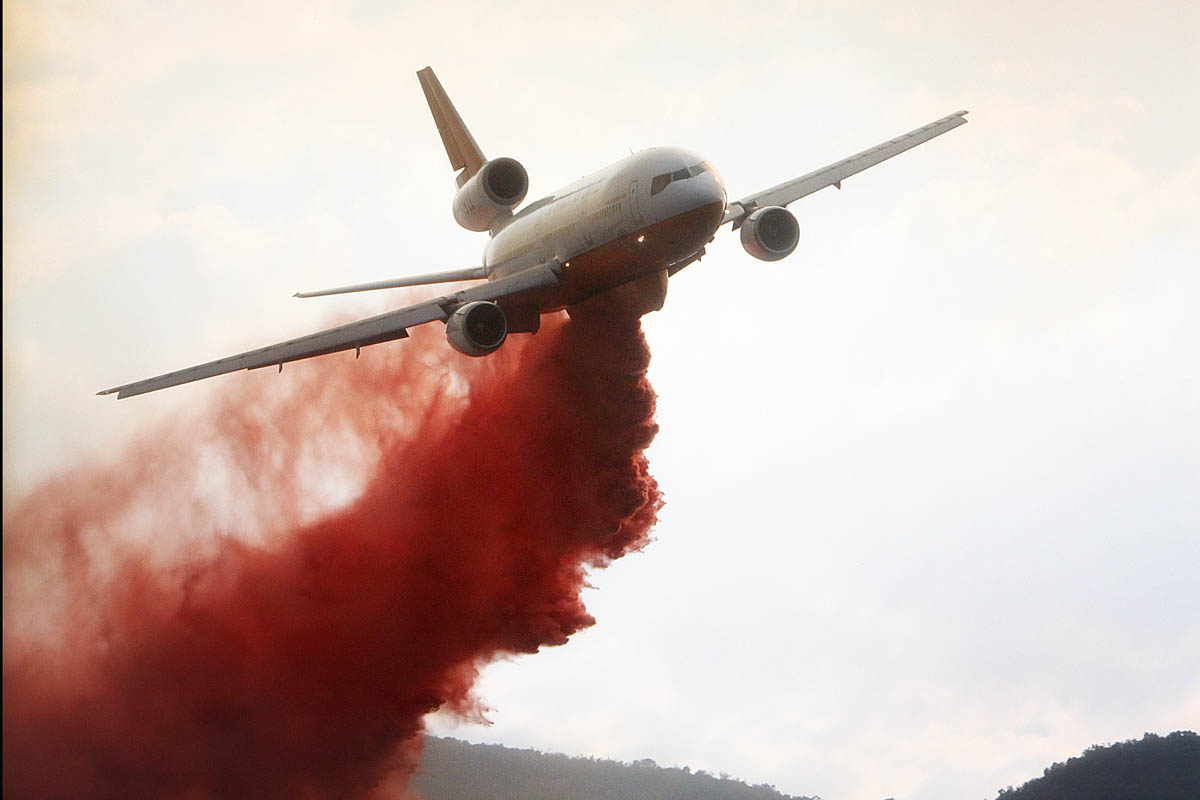
Rose Fire Lake Elsinore CA
A DC-10 drops on the Rose Fire near Lake Elsinore, CA, July 31, 2017 Photo by Jeff Zimmerman.

Continue reading “Rose Fire near Lake Elsinore, California burns 200 acres”